|
| Interstate 70 continues the climb west from Mount Vernon Canyon to Genesee Mountain and Genesee Park. 08/15/13 |
|
| U.S. 40 loops alongside Mount Vernon Creek to the north and west back to Interstate 70 at a diamond interchange (Exit 254) in one mile. 08/15/13 |
|
| A chain station lies just beyond the exchange at Genesee Park. 08/15/13 |
|
| The buffalo herd is located on private property on a hillside rising north of I-70. An overlook lines the freeway at the U.S. 40 westbound entrance ramp from Exit 254. 08/15/13 |
|
| A variety of homes and condominiums populate the neighborhoods accessed via Exit 254, both south along Genesee Trail or Genesee Mountain Road and north of U.S. 40 along Mt. Vernon Country Club Road. 08/15/13 |
|
| A slip ramp (Exit 254) departs underneath the Genesee Park overpass from I-70 westbound for the both buffalo herd overlook and a chain station. 08/15/13 |
|
| Construction of Interstate 70 between Genesee Park and SH 74 in 1972 directly replaced U.S. 40 west. 08/15/13 |
|
| The diamond interchange at Exit 253 is northwest of Genesee Mountain at Chief Hosa. 08/15/13 |
|
| Exit 253 leaves I-70/U.S. 40 west for Moss Road Rock west and Genesee Drive east to the adjacent Chief Hosa Lodge. 08/15/13 |
|
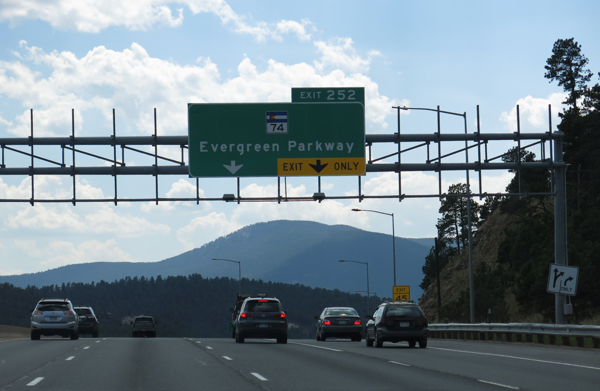
| SH 74 commences a 18.11 mile long loop south to Bergen Park, Evergreen and east to Kittredge and Morrison from Interstate 70 west at Exit 252. 08/15/13 |
|
| An auxiliary lane accompanies Interstate 70 west from Chief Hosa to the wye interchange (Exit 252) with SH 74 (Evergreen Parkway) eastbound. 08/15/13 |
|
| U.S. 40 separates from I-70 at Exit 252. SH 74 winds southwest to Hidden Valley while U.S. 40 converges with I-70 again just west of El Rancho. 08/15/13 |
|
| U.S. 40 stems west from SH 74 (Evergreen Parkway) at the commercialized intersection with Swede Gulch Road. U.S. 40 shifts to the north of I-70 at a nearby half diamond interchange (Exit 251 from I-70 east). 08/15/13 |
|
| Interstate 70 makes a series of S-curves west from El Rancho toward Shaffer and Floyd Hills. 08/15/13 |
|
| Saddleback Mountain rises west of Interstate 70 and north of Beaver Brook Canyon. 08/15/13 |
|
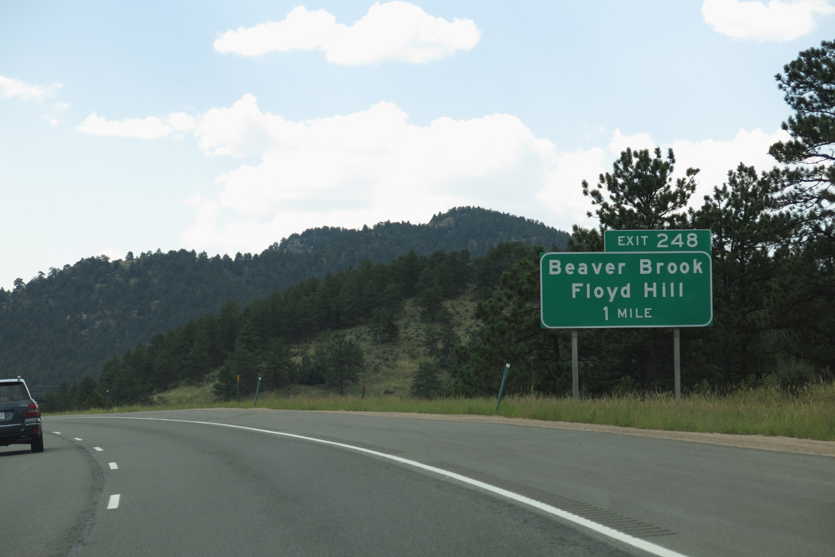
| One mile ahead of Exit 248 for Beaver Brook and Floyd Hill on Interstate 70 west. 08/15/13 |
|
| Exit 248 constitutes a split diamond interchange with CR 65 (Bergen Park Road) to the east, and an access road to the west linking I-70 with parallel U.S. 40, CR 182 (Beaver Brook Canyon Road) and CR 181 (Hyland Drive). 08/15/13 |
|
| Wildlife hazards along Interstate 70 include Moose. 08/15/13 |
|
| Interstate 70 crosses the Clear Creek County line north of Beaver Brook and Shaffer Hill. 08/15/13 |
|
| A lane drop occurs along Interstate 70 westbound at the entrance ramp from Homestead Road / Exit 247. 08/15/13 |
|
| Interstate 70 descends at a 6% grade west from Floyd Hill to Clear Creek Canyon. 08/15/13 |
|
| Interstate 70 and parallel U.S. 40 curve north from Saddleback Mountain to Johnson Gulch. 08/15/13 |
|
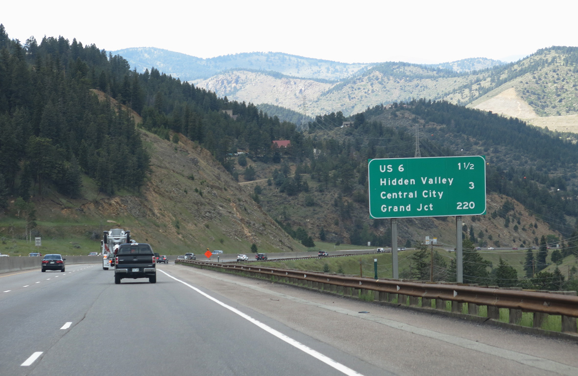
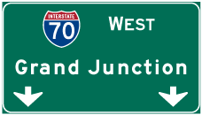
| U.S. 6/40 converge with Interstate 70 at the succeeding exit in 1.5 miles. Grand Junction is 220 miles away. 08/15/13 |
|
| Interstate 70 descends over 500 feet in elevation from west of the Clear Creek County line to Clear Creek. 08/15/13 |
|
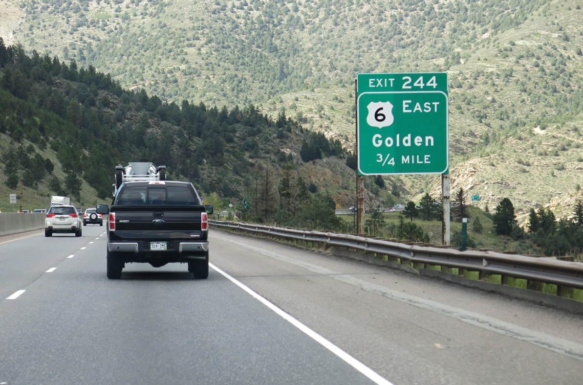
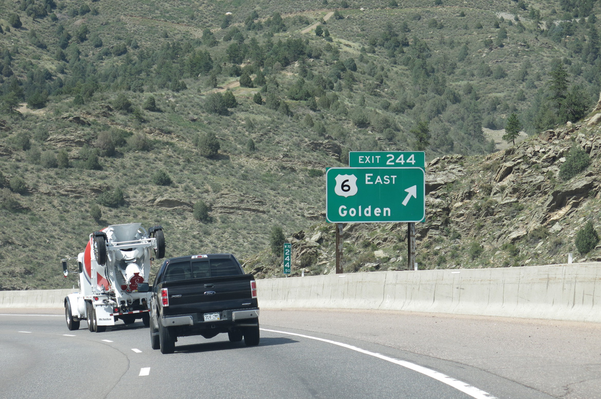
| Segment G of U.S. 6 (Route 00G) runs 27.58 miles west from I-25/U.S. 85-87 and Sixth Avenue Freeway at Lincoln Park in Denver to I-70 at Exit 244. 08/15/13 |
|
| U.S. 6 east through Clear Creek Canyon passes through five tunnels, two of which precede the connection in 2.99 miles with the Peak-to-Peak Highway, SH 119 north to Black Hawk and SH 72 at Nederland. 08/15/13 |
|
| U.S. 6 winds 14.3 miles east through Clear Creek Canyon, from Exit 244 to SH 58 (Golden Freeway) and SH 93 in Golden. 08/15/13 |
|
| U.S. 6/40 overlap 0.67 miles east from Interstate 70 by Walstrum Quarry. 09/01/04 |
|
| Interstate 70 overtakes U.S. 6/40 west from Clear Creek Canyon to Idaho Springs. Left exit ramps connect the two highways just north of Clear Creek. 08/15/13 |
|
| U.S. 40 branches west from I-70/U.S. 6 in ten miles to Empire. Grand Junction is 204 miles further along Interstate 70. 09/01/04 |
|
| Advancing west from Sawmill Gulch, I-70/U.S. 6-40 next meet Central City Parkway north and Idaho Springs Road (CR 314) at Exit 243. 08/15/13 |
|
| Entering the Idaho Springs city limits, Exit 243 departs I-70 west. Providing an alternate route, CR 314 (E Idaho Springs Road) follows old U.S. 6/40 west to the Idaho Springs business loop. 08/15/13 |
|
| Central City Parkway opened north from the diamond interchange at Exit 243 to Central City and Blackhawk on November 19, 2004.1 08/15/13 |
|
| Costing $55 million, the Twin Tunnels project expanded the bores along both directions of Interstate 70 with an tolled Express Lane. Work ran from April 2013 to December 2014.2 08/15/13 |
|
| The Twin Tunnels along Interstate 70 were renamed the Veterans Memorial Tunnels by State Legislation passed in April 2015. 09/01/04 |
|
| The Mountain Express Lane commences westbound from the Veterans Memorial Tunnels to Empire. 12 miles long, the managed lanes opened on July 30, 2021.3 09/01/04 |
|
| The Veterans Memorial Tunnels are 700 feet in length.4 09/01/04 |
|
| CR 314 west becomes Colorado Boulevard through the exchange at Exit 241. Prior to 2016, Colorado Boulevard (old U.S. 6/40 was designated Business Loop I-70. A 0.523 mile section at Exit 241 remains state maintained as Route 070R. 08/15/13 |
|
| Construction from April to Fall 2015 rebuilt the exchange at Exit 241, consolidating separate ramps to connect with Colorado Boulevard at a roundabout.5 Business Loop I-70 formerly ran 2.71 miles across Idaho Springs. 08/15/13 |
|
| I-70 advances along the south side of Idaho Springs to a diamond interchange with SH 103 (13th Avenue). SH 103 is the Mount Evans Scenic Byway. 08/15/13 |
|
| Interstate 70 crosses Clear Creek again north of Flirtation Peak. 08/15/13 |
|
| A 22.41 mile long highway, SH 103 loops back toward Denver via Juniper Pass and Squaw Pass, changing into Clear Creek County Route 103 and Jefferson County Route 66 to SH 74 (Evergreen Parkway) in Wah Keeney Park. 08/15/13 |
|
| SH 103 (Mount Evans Highway) south to Arapaho National Forest links with SH 5, the highest paved road in the United States. SH 5 leads to the summit of Mount Evans (el. 14,264 feet). 09/01/04 |
|
| I-70/U.S. 6-40 run west between Clear Creek and Miner Street to Exit 239. 08/15/13 |
|
| Exit 239 separates from I-70 westbound to Miner Street at 3rd Avenue, two blocks south of Colorado Boulevard (former Business Loop I-70). 08/15/13 |
|
| Colorado Boulevard returns to I-70 at a half diamond interchange with CR 321 (Stanley Road). The westernmost 0.212 miles of Colorado Boulevard are inventoried by CDOT as Route 070K. 08/15/13 |
|
| A modified diamond interchange (Exit 238) joins Interstate 70 west with Falling River Road (CR 275) west of Oro Gulch. 08/15/13 |
|
| County Route 275 follows the Fall River toward the community of Alice, St. Mary's Glacier and Fox Mountain. 08/15/13 |
|
| CR 275 (Fall River Road) spurs 9.39 miles north from I-70 by Bellevue Mountain to Alice Drive by Silver Lake. 08/15/13 |
|
| CR 312 (Stanley Road) follows the south banks of Clear Creek along the old alignment for U.S. 6-40. 08/15/13 |
|
| The Westbound I-70 Mountain Express Lane was constructed from July 2019 to November 2021. When not in use, the Peak Period Shoulder Lane (PPSL) functions as a shoulder.6 08/15/13 |
|
| Continuing west, Interstate 70 passes between Spring Gulch and the northern slopes of Alps Mountain. 08/15/13 |
|
| CR 312/Stanley Road (old U.S. 6/40) reconnects with I-70 at the half diamond interchange at Exit 235 and County Road CR 308). 08/15/13 |
|
| Exit 235 leaves I-70 west for the unincorporated community of Dumont and CR 261 (Mill Creek Road) northwest into Arapaho National Forest. 08/15/13 |
|
| The Dumont Weigh Station lies just off Interstate 70 from the entrance ramp at Exit 234. 08/15/13 |
|
| Paralleling the north side of I-70, CR 308 (County Road) continues the old alignment of U.S. 6/40 west from Dumont to Exit 234 CR 308 intertwines with the freeway west into Lawson. 08/15/13 |
|
| West from Downieville, Interstate 70 runs south of Red Elephant Hill. 08/15/13 |
|
| U.S. 40 parts ways with I-70/U.S. 6 west at Exit 232. U.S. 40 enters the town of Empire nearby, then ascends to Berthoud Pass (el. 11,315 feet), while Interstate 70 advances toward Loveland Pass. 08/15/13 |
|
| I-70 and U.S. 40 are both part of routes to Salt Lake City, Utah. U.S. 40 travels through the remote northwestern corner of Colorado, including Dinosaur National Monument to Vernal, Utah en route to Park City and I-80. U.S. 6 branches northwest from I-70 beyond Green River, Utah to I-15 at Spanish Fork. 08/15/13 |
|
| U.S. 40 west leads to such popular ski resorts as Winter Park and Steamboat Springs. 08/15/13 |
|
| U.S. 40 meets the west end of U.S. 34 at the town of Granby in Grand County. U.S. 34 travels northeast from there to Rocky Mountain National Park. 08/15/13 |
|
| U.S. 40 reaches Winter Park in 26 miles and Granby in 45 miles. U.S. 40 provides a back route into central Wyoming, via northbound SH 125 west of Granby or northbound SH 13 at Craig. 08/15/13 |
Page Updated 01-22-2022.

 West
West


 West
West