| Interstate 80 west |
|
Interstate 80 passes under Nevada 794 (Winnemucca Boulevard) on the approach to Nevada 289 (2nd Street) and downtown Winnemucca. Nevada 289 follows Winnemucca Boulevard east from U.S. 95 (Melarkey Street) to junction Business Loop I-80 & Nevada 794 at 2nd Street. The state route continues east along 2nd Street to Weso. Photo taken 09/09/05. |
|
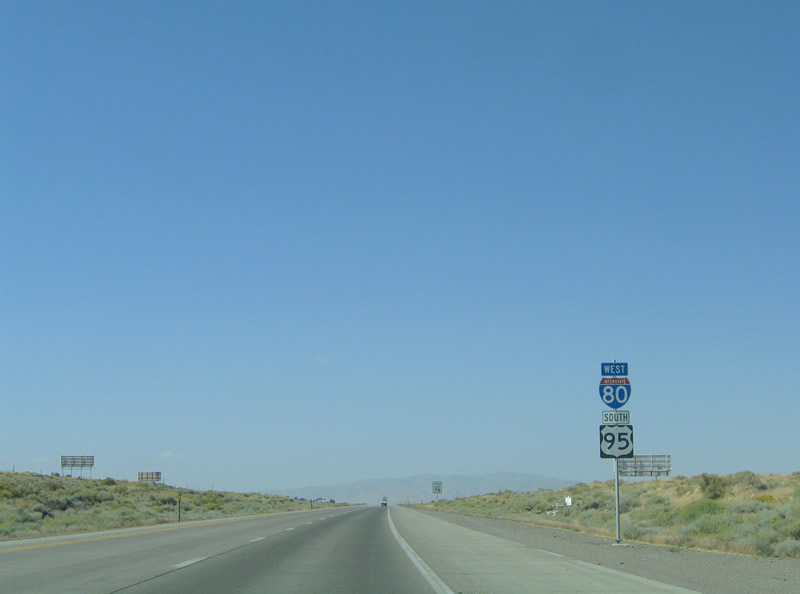
Traffic interests to U.S. 95 northbound for Boise, Idaho and Lakeview, Oregon (via Nevada 140 / Oregon 140 west) should use Exit 178 from Interstate 80 onto Nevada 289 (2nd Street) westbound. Nevada 289 merges with Business Loop I-80 along Winnemucca Boulevard one half mile east of their intersection with U.S. 95 (Melarkey Street) at downtown Winnemucca. From there U.S. 95 turns northward underneath Interstate 80 on the 31-mile drive to Nevada 140 (Winnemucca-to-the-Sea Highway). There is no direct access between Interstate 80 and U.S. 95 north of downtown. Photo taken 09/09/05. |
|
One half mile east of the Exit 178 diamond interchange with Nevada 289 (2nd Street) on Interstate 80 west. Winnemucca represents a service center for the farming and ranching industry of northern Nevada. Like Elko and Battle Mountain to the east, the city also saw a boon in conjunction with the surge of mining activity in the late 20th century. Gold silver, dolomite, and limestone are mined in the area. Photo taken 09/09/05. |
|
Westbound at the Exit 178 off-ramp to Nevada 289 (2nd Street). Nevada 289 spurs 3.138 miles east from downtown Winnemucca to Weso. Weso lies between the Humboldt River and Union Pacific Railroads northeast of town. Photo taken 09/09/05. |
|
Ascending along the Exit 178 ramp to Nevada 289 (2nd Street). A U.S. 95 trailblazer directs traffic onto Nevada 289 westbound for Business Loop I-80 and Winnemucca Boulevard. Nevada 794 ends to the south of the freeway. Photo taken 09/09/05. |
|
Interstate 80 bypasses downtown Winnemucca to the north. The freeway meets U.S. 95 directly at the Exit 176 diamond interchange with Winnemucca Boulevard (Business Loop I-80) outside of downtown. There U.S. 95 southbound joins Interstate 80 for a 93-mile overlap. Photo taken 09/09/05. |
|
U.S. 95 travels 74 miles south from McDermitt near the Oregon state line to downtown Winnemucca. The U.S. highway joins Business Loop I-80 along Winnemucca Boulevard (old U.S. 40) for 1.6 miles. Photo taken 09/09/05. |
|
Interstate 80 westbound at the Winnemucca Downtown West interchange (Exit 176). U.S. 95 northbound & Business Loop I-80 eastbound follow Winnemucca Boulevard into downtown to Nevada 289. Winnemucca Boulevard westbound (old U.S. 40) continues alongside Interstate 80 to Exit 173. Photo taken 09/09/05. |
|
U.S. 95 southbound merges onto Interstate 80 west for the drive to Exit 83 north of Fallon. Pictured here is the first reassurance shield assembly of the overlap. Photo taken 09/09/05. |
|
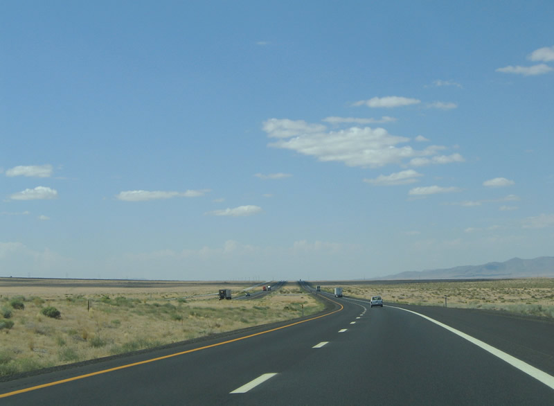
The next town of consequence along Interstate 80 is that of Lovelock, found at Exits 107 and 106. The split with U.S. 95 lies 93 miles ahead. Photo taken 09/09/05. |
|
Business Loop I-80 (Winnemucca Boulevard) returns to Interstate 80 & U.S. 95 at Exit 173. Photo taken 09/09/05. |
|
A diamond interchange joins Business Loop I-80 (Winnemucca Boulevard) with Interstate 80 & U.S. 95 at Exit 173. Old U.S. 40 spurs west from Winnemucca Boulevard along the eastbound side of the freeway via Rose Creek Road. An abandoned truck stop lies at the north side of the interchange. Photo taken 09/09/05. |
|
Use Business Loop I-80 (Winnemucca Boulevard) eastbound for the Airport Industrial Loop. A growing industrial business park resides along Winnemucca Boulevard east of Exit 173. Photo taken 09/09/05. |
|
Interstate 80 west and U.S. 95 south enter the final Winnemucca interchange (Exit 173). Rose Creek Road (old U.S. 40) serves Winnemucca Municipal Airport via its connection with Airport Road to the west of Exit 173. Photo taken 09/09/05. |
|
Pushing westward along Interstate 80 & U.S. 95 between west Winnemucca and Rose Creek. Photo taken 09/09/05. |
|
Rose Creek Road (old U.S. 40) ties into Interstate 80 & U.S. 95 at the Exit 168 diamond interchange at Rose Creek. Rose Creek the western extant of the western suburbs of Winnemucca. Old U.S. 40 remains to the south of the freeway. Photo taken 09/09/05. |
|
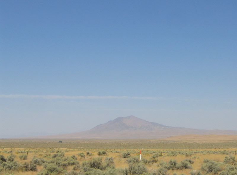
Blue Mountain (el. 7,342) rises along the northern horizon as part of the Eugene Mountains west of Winnemucca. Photo taken 09/09/05. |
|
A short access road links Interstate 80 & U.S. 95 with the parallel Rose Creek Road (old U.S. 40) at Exit 168. Photo taken 09/09/05. |
|
|
Blue Mountain and the Humboldt Range lie in view along Interstate 80 west and U.S. 95 south between Rose Creek and Mill City (Exit 149). Photos taken 09/09/05. |
|
Interstate 80 & U.S. 95 turn more southwesterly at the Pershing County line. Advancing to Mill Creek and Imlay, I-80 passes by Star Peak (el. 9,836) ft). Photo taken 09/09/05. |
|
Approaching the settlement of Cosgrave (Exit 158) on Interstate 80 west and U.S. 95 south. The forthcoming diamond interchange serves an adjacent rest area. Photo taken 09/09/05. |
|
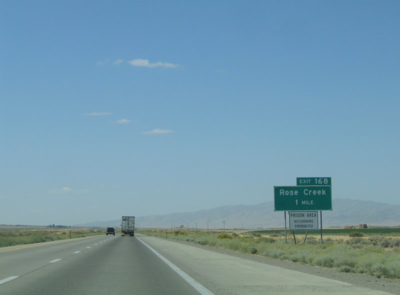
Rest area sign posted along Interstate 80 & U.S. 95 west for Exit 158. The final rest area within Nevada lies 76 miles ahead near Fernley. Photo taken 09/09/05. |
|
Interstate 80 & U.S. 95 intersect local roads at the Cosgrave interchange of Exit 158. Cosgrave and Raspberry Creek exist just northwest along the Union Pacific Railroad line. Old U.S. 40 remains along the eastbound side of the freeway. Photo taken 09/09/05. |
|
Interstate 80 & U.S. 95 travel the Humboldt River valley between the East Range and Eugene Mountains southwest to Mill City and the Humboldt Range. Star Peak remains the focal point of westbound travelers. Photo taken 09/09/05. |
|
The first of two interchanges in the Mill City area (Exit 151) serves Dunglen via old U.S. 40 and Dunglen Road. Old U.S. 40 parallels the westbound side of the freeway between Exits 151 and 138 (Imlay). Dunglen Road spurs southeast from Exit 151 to Barber Canyon Road. Photo taken 09/09/05. |
|
A diamond interchange facilitates the movements between Dunglen Road, Old U.S. 40 (Frontage Road), and Interstate 80 & U.S. 95. Old U.S. 40 travels west to Mill City from Dunglen. Photo taken 09/09/05. |
|
Nevada 400 (Unionville Road) meets I-80/U.S. 95 at Mill City and Exit 149. Nevada 400 serves Unionville, an old mining village founded in the early 1860s. Nevada 400 travels 16.477 miles south through the Buena Vista Valley to Unionville. Photo taken 09/09/05. |
|
Westbound at the Exit 149 diamond interchange with Nevada 400 (Unionville Road) south and Toncston Road north. Old U.S. 40 (Frontage Road) intersects the north-south road at the north side of the exit at Mill City. Toncston Road continues north from Mill City to the site of Tungsten. Photo taken 09/09/05. |
|
Interstate 80 & U.S. 95 curve westward toward the community of Imlay (Exit 145). Imlay represents another mining community and is fueled by the Florida Canyon Gold Mine. The settlement lies at north end of the Humboldt Range and east of the Rye Patch Reservoir. Photo taken 09/09/05. |
|
A short access road joins the adjacent frontage roads (old U.S. 40) with Interstate 80 & U.S. 95 at Imlay. The town itself lies to the north of the freeway. Photo taken 09/09/05. |
|
The only state-named Interstate 80 shield co-signed with U.S. 95 along the 93-mile long overlap, posted after Exit 145. Photo taken 09/09/05. |
|
|
Interstate 80 & U.S. 95 turn southward from Imlay to Rye Patch Dam. The Eugene Mountains lies north of the nearby Rye Patch Reservoir and State Recreation Area. The Humboldt Range lies to the south and east. Photos taken 09/09/05. |
|
Nearing Humboldt (Exit 138) on Interstate 80 west and U.S. 95 south. The rural area is home to the 10,000 acre Humboldt River Ranch subdivision. The private development is home to one to ten acre lots and a small resort consisting of a lodge, cabins, and offices. Photo taken 09/09/05. |
|
A small stand of trees represent the development at the Humboldt diamond interchange with the adjacent frontage roads (old U.S. 40). There are no traveler services at the exit. Photo taken 09/09/05. |
|
Exit 138 departs Interstate 80 west and U.S. 95 south at Humboldt. The Humboldt River Ranch subdivision encompasses much of the Humboldt Range foothills to the east. A 15-acre campsite exists along the Humboldt River to the west. Photo taken 09/09/05. |
|
|
|
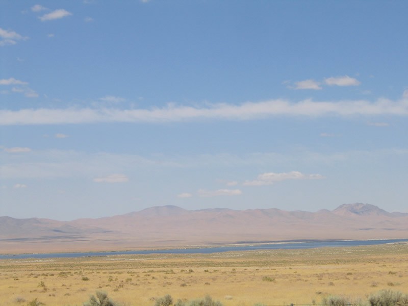
Continuing southward on the drive to Lovelock adjacent to the Rye Patch Reservoir and State Recreational Area. The northern extant of the Trinity Range reaches across the western horizon. Fed by the Humboldt River, the Rye Patch Reservoir supplies water for the Lovelock Irrigation District. The 22-mile long reservoir was built in 1936 and varies in depth depending upon yearly rainfall. The body of water last went bone dry in fall of 1992. Photos taken 09/09/05. |
|
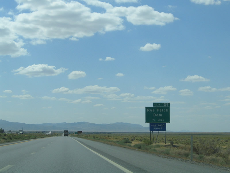
Rye Patch Road (Nevada 401) intersects Interstate 80 & U.S. 95 at Exit 129. The road travels east-west from the Rye Path Dam (el. 4,133 ft) to ranch areas east of the freeway. Photo taken 09/09/05. |
|
One half mile north of the Exit 129 diamond interchange on Interstate 80 west and U.S. 95 south. The Rye Patch Dam itself rises to 72 feet above the riverbed and is 800 feet long. Nevada 401 (Rye Patch Road) travels across the dam within the State Recreation Area. Photo taken 09/09/05. |
|
Nevada 401 (Rye Patch Road) stems 2.256 miles west from the junction into the Rye Patch State Recreation Area. The park provides camping facilities, boat launch sites, swimming, and fishing. Photo taken 09/09/05. |
|
Interstate 80 west and U.S. 95 southbound at the Exit 129 off-ramp to Nevada 401 west, the Rye Patch Dam and the Rye Patch State Recreation Area. The Union Pacific Railroad returns to parallel the freeway from the northwest. Old U.S. 40 meanwhile serves ranching areas well east of the interchange. Photo taken 09/09/05. |
|
|
Interstate 80 & U.S. 95 travel almost due south from Rye Patch Dam to Oreana. The western fringes of the Humboldt Range again come into view along the ten-mile drive between exits. Photos taken 09/09/05. |
|
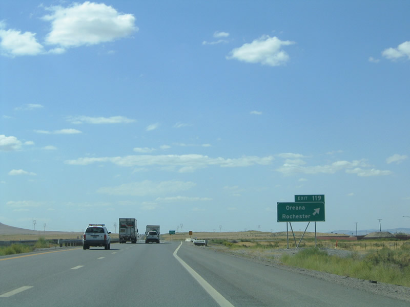
Unionville Road, what was Nevada 400 at Exit 149, returns to Interstate 80 & U.S. 95 at Exit 119. Unionville Road serves Oreana west of the freeway and the site of Rochester in the mountains to the east. Photo taken 09/09/05. |
|
Oreana represents an old mining center along the Humboldt River. The community once produced lead and tungsten, and now represents a settlement of a few homes and warehouses. Unionville Road travels east from the village into the Humboldt Range toward the Coeur Rochester Mine and former village of Rochester. Pictured here is the Exit 119 westbound off-ramp of the diamond interchange. Photo taken 09/09/05. |
|
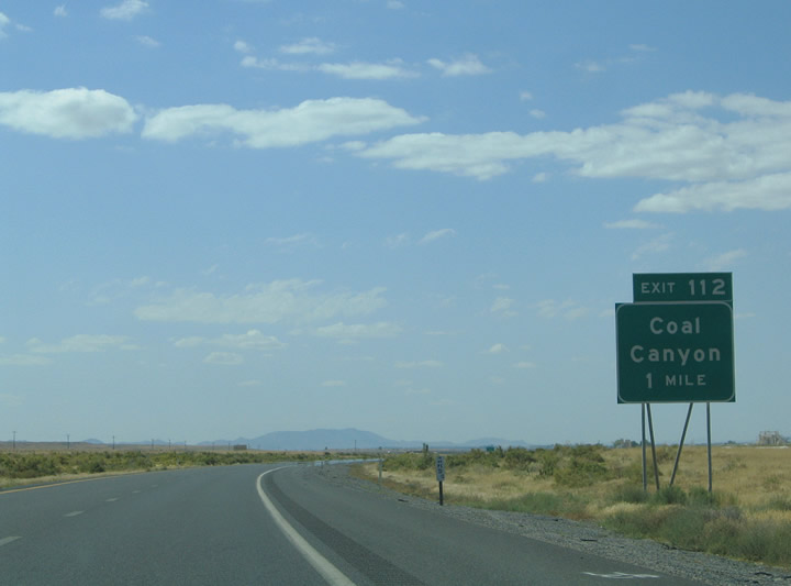
Interstate 80 & U.S. 95 continue another seven miles southwest to Coal Canyon and Nevada 396 (Exit 112). Nevada 396 travels 7.575 miles west along Coal Canyon Road to old U.S. 40 & 95 (Upper Valley Road). The state route cosigns with Business Loop I-80 through downtown Lovelock. Photo taken 09/09/05. |
|
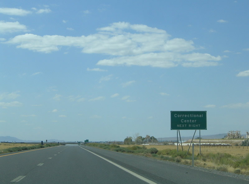
Exit 112 serves the Lovelock state prison and ranch areas northeast of town. The Union Pacific Railroad parallels old U.S. 40 & 95 to the west. Signs are posted along the freeway prohibiting the picking up of hitchhikers in the area. Photo taken 09/09/05. |
|
Exit 112 departs Interstate 80 west and U.S. 95 south for Coal Canyon Road and Nevada 396 south. Nevada 396 merges with old U.S. 40 & 95 one half mile to the west. Coal Canyon Road rises into the Humboldt Range east of here. Photo taken 09/09/05. |
|
|
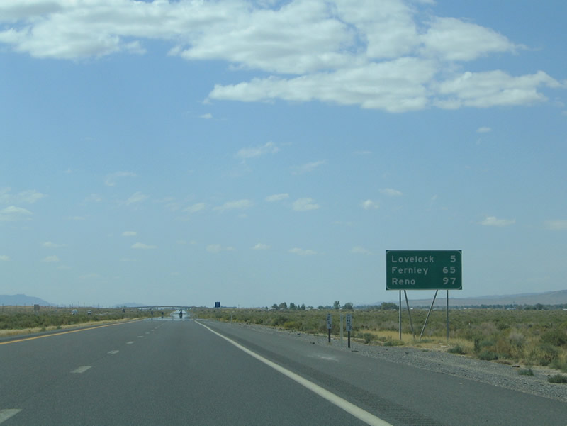
U.S. 95 was omitted from the Interstate 80 westbound reassurance shield assembly west of Coal Canyon. The assembly and mileage sign exist on the five mile approach to Lovelock. Photos taken 09/09/05. |
|
Entering the Lovelock area on Interstate 80 west and U.S. 95 south, the city of 2,000 was founded in 1866 by the Central Pacific Railroad company. Lovelock's namesake is derived from George Lovelock, a Welsh miner who donated 85 acres to the railroad company in return for its name. From there Lovelock grew as a farming community with its attraction of cattlemen and ranchers. By the 1900s, reservoirs along the Humboldt River irrigated 8,000 acres of adjacent land. The completion of the Rye Patch Dam in 1936 increased the irrigable lands to 40,000 acres. The 1919 partitioning of Humboldt County and formation of Pershing County landed Lovelock the seat of the new county. The town today survives as a farming community. Photo taken 09/09/05. |
|
Westbound Interstate 80 and southbound U.S. 95 meet Exit 107, Junction Business Loop I-80 at the East Lovelock Interchange. Business Loop I-80 joins Nevada 856 along Airport Road from Exit 107 to Nevada 396 (Old U.S. 40/95). Nevada 856 comprises a 1.135-ile long spur from Downtown Lovelock to Lovelock Airport east of the freeway. Photo taken 09/09/05. |
|
Business Loop I-80 auxiliary guide sign posted ahead of the Exit 107 half-diamond interchange with Airport Road (Nevada 856). The business loop follows Nevada 856 west to Nevada 396 (Cornell Avenue) south through downtown Lovelock. The loop returns to Interstate 80 at the Exit 105 half-diamond interchange south of the business district. Photo taken 09/09/05. |
|
Business Loop I-80 westbound departs Interstate 80 & U.S. 95 at Nevada 856 (Airport Road). Airport Road continues east of the freeway to ranch areas outside of town. Nevada 856 west arcs 0.7 miles west to its end at Nevada 396 (Cornell Avenue / Upper Valley Road). Use Exit 107 for the Paiute Indian Reservation. Photo taken 09/09/05. |
Page Updated July 9, 2012.