| Interstate 80 west |
|---|
|
After Business Loop I-80 and U.S. 95 Alternate split from the freeway, westbound Interstate 80 proceeds alone for the first time since entering Winnemucca. Interstate 80 bypasses the city of Fernley between Exits 48 and 46, with the downtown area located along Old U.S. 40 just south of the freeway. The next interchange along Interstate 80 west is Business Loop I-80, Nevada 427, and Old U.S. 40/Main Street east and Business Loop I-80 and Nevada 427/Wadsworth Boulevard west to the unincorporated community of Wadsworth. The city of Fernley was founded in 1905 in conjunction with the Newlands Reclamation Project. The town consisted of a small trade center and railroad outpost until the early 1960s. In modern times Fernley represents a bedroom community for the city Reno due to the direct high speed connection that Interstate 80 provides as well as the first motorist services along Interstate 80 since leaving Lovelock. Photo taken 09/09/05. |
|
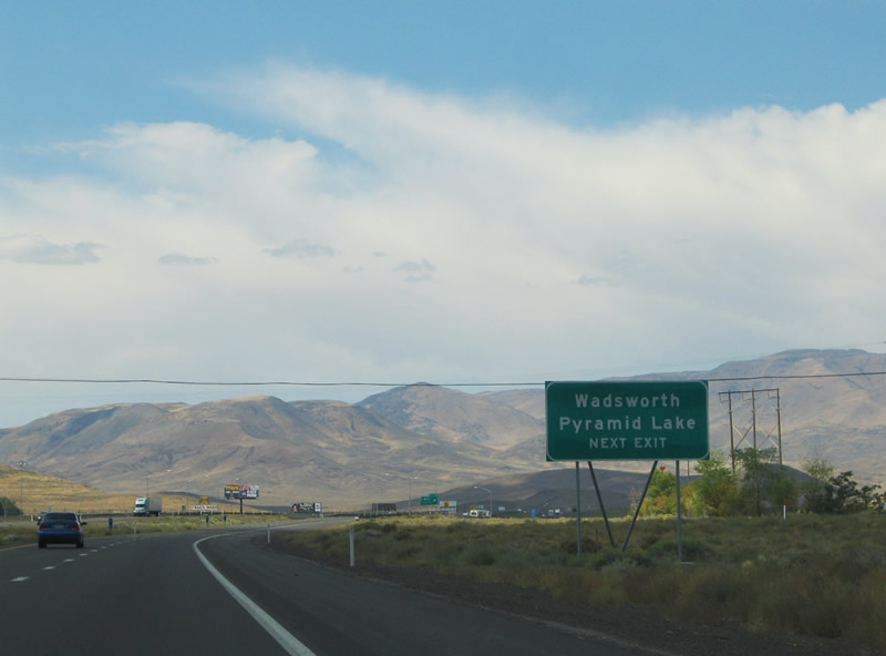
Nevada 427 and Business Loop I-80 loops 3.2 miles into Wadsworth between Exits 46 and 43. The state route provides a connection to Nevada 447 (Gerlach Road) in downtown Wadsworth. Nevada 447 stems 74.689 miles north to Pyramid Lake, Gerlach, and Eagleville, California. Business Loop I-80 loops east on Main Street into downtown Fernley and U.S. 50 Alternate and U.S. 95 Alternate from Exit 46 southward. Photo taken 09/09/05. |
|
Interstate 80 crosses into Storey County between the two Wadsworth interchanges (Exits 46 & 43). The Virginia Mountains lie along the western horizon. Photo taken 09/09/05. |
|
The next exit along Interstate 80 west is Exit 43, Nevada 427/Wadsworth Boulevard (one mile). This interchange will serve as the western terminus of Nevada 427, which is old U.S. 40 and may also be part of Business Loop I-80. Cantlon Drive continues alongside Interstate 80 west into the Virginia Mountains. Photo taken 09/09/05. |
|
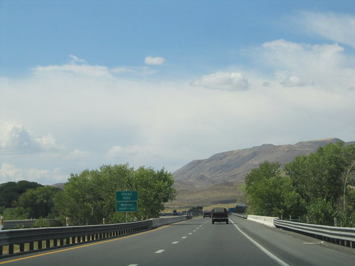
Before Interstate 80 reaches Exit 43, the freeway crosses the Truckee River and enters Washoe County, the final county westbound travelers encounter within the state of Nevada along Interstate 80. Photo taken 09/09/05. |
|
Westbound Interstate 80 meets Exit 43, Nevada 427/Wadsworth Boulevard east to Wadsworth and Cantlon Drive west. The next travel services lie 30 miles ahead within the city of Sparks. Photo taken 09/09/05. |
|
|
|
|
|
|
| Interstate 80 enters a 25-mile long stretch of freeway through Truckee River Canyon between Wadsworth and Sparks. A rest area resides just west of Exit 43 on the descent toward the Reno metropolitan area. The Central Pacific Railroad (now Union Pacific Railroad) originally traversed the canyon in the 1800s. Construction began in 1919 for a highway route through the canyon of what would later become U.S. 40. U.S. 40 existed as an unpaved route in 1927, and a completed paved route by 1934. Interstate 80 road work commenced in the 1950s with completion by 1959 at a cost of $10 million. Photos taken 09/09/05. |
|
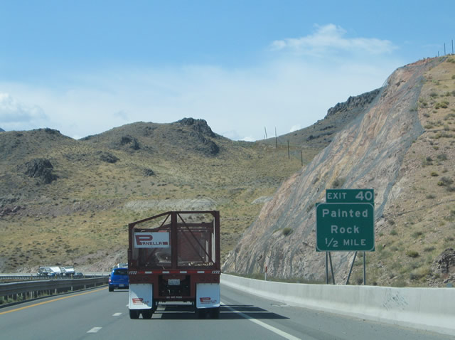
The next exit along Interstate 80 west is Exit 40, Painted Rock Road (one mile) at a diamond interchange. Use this exit to see a 1902 truss bridge with wood decking and access the Union Pacific Railroad along the south side of the freeway. Photo taken 09/09/05. |
|
Westbound Interstate 80 reaches Exit 40, Painted Rock Road. No motorist services are available at this interchange. A frontage road loops east to Cantlon Drive near milepost 43. Photo taken 09/09/05. |
|
The next exit along Interstate 80 west is Exit 38, Old Orchard (one mile) at a diamond interchange. Photo taken 09/09/05. |
|
Westbound Interstate 80 reaches Exit 38, Old Orchard. The Old Orchard interchange serves an isolated area of the Truckee River Canyon alongside the Union Pacific Railroad. A local road spurs south from the freeway. Photo taken 09/09/05. |
|
|
Two more views of the Truckee River Canyon as seen from Interstate 80 westbound between Orchard and Derby Dam. The Union Pacific Railroad and the Truckee River continue parallel along the eastbound side of the freeway. Pond Peak (elevation 8,010 feet above sea level) lies to the north. Photos taken 09/09/05. |
|
Westbound Interstate 80 reaches Exit 36, Derby Dam (a diamond interchange). Constructed in 1905 by the fledgling U.S. Bureau of Reclamation, the Derby Dam diverts water to the Truckee Canal, a 35-mile long waterway between Fernley and Lahontan Reservoir. Photo taken 09/09/05. |
|
|
|
|
|
| These additional views of the scenic Truckee River Canyon between Derby Dam and Tracy Station Power Plant (near USA Parkway) are afforded along Interstate 80 west. Photos taken 09/09/05 and 07/31/12. |
|
|
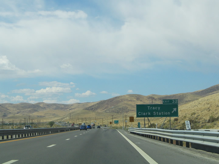
The next exit along Interstate 80 west is Exit 32, USA Parkway (formerly Clark Station Road). USA Parkway is a partially completed roadway that is planned to eventually connect between Interstate 80 and U.S. 50 near Silver Springs. Built and financed privately, USA Parkway adopts the alignment of what is planned to be Nevada 439 once the roadway is complete (the existing segment of USA Parkway as of 2012 is not yet in the state route system).1 Photos taken 07/31/12 and 09/09/05. |
|
Westbound Interstate 80 approaches Exit 32, USA Parkway (proposed/unconstructed Nevada 439), one-half mile. Prior to the construction of the diamond interchange with USA Parkway, Exit 32 used to be a trumpet interchange with Clark Station Road. This road still exists but no longer directly connects to the Interstate. Waltham Way links USA Parkway with the Tracy Station Power Plant. The plant, opened in 1963, produces energy from gas and oil. Photo taken 07/31/12. |
|
|
Westbound Interstate 80 reaches Exit 32, USA Parkway (formerly Clark Station Road/future Nevada 439) at this diamond (formerly trumpet) interchange. Wunotoo Road intersects Clark Station Road just south of the freeway. Wunotoo Road travels west then south to Waltham Way. Photos taken 07/31/12 and 09/09/05. |
|
|
The aforementioned power plant comes into view on the south side of Interstate 80. Several power lines, some of which have paralleled Interstate 80 since near Battle Mountain, come into a large substation adjacent to Tracy Station Power Plant. Photo taken 07/31/12. |
|
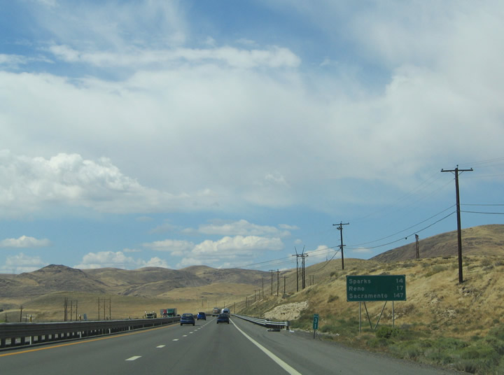
Interstate 80 continues another 14 miles to Sparks and 17 miles to downtown Reno from Tracy and Clark Station. Photo taken 09/09/05. |
|
|
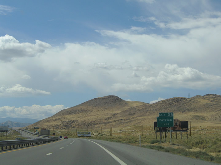
The next exit along Interstate 80 west is Exit 28, Nevada 665/Waltham Way and Patrick. Meeting the freeway at Patrick here is Nevada 655 (Waltham Way), a 1.1-mile long route between Interstate 80 and the Storey County Line to the south and east, with a bridge over the Truckee River. Photos taken 09/09/05. |
|
Westbound Interstate 80 meets Exit 28, Nevada 665/Waltham Way and Patrick. No motorist services are available here, and Nevad 665 is not a through route (it is just a spur route). Patrick derives its name from the nearby McCarran Ranch and Senator Patrick McCarran. A folded-diamond interchange facilitates the movements between Interstate 80, Waltham Way, and McCarran Ranch Road. Photo taken 09/09/05. |
|
|
Interstate 80 passes through a large cut through McCarran Hill between Patrick and Mustang. 230 feet of the original hill were removed for the highway's construction. Photos taken 09/09/05. |
|
The last Nevada check station, or weigh station, lies ahead of the Mustang interchange along Interstate 80 west. The station requires all commercial vehicles or vehicles carrying livestock to stop for inspection. Photo taken 09/09/05. |
|
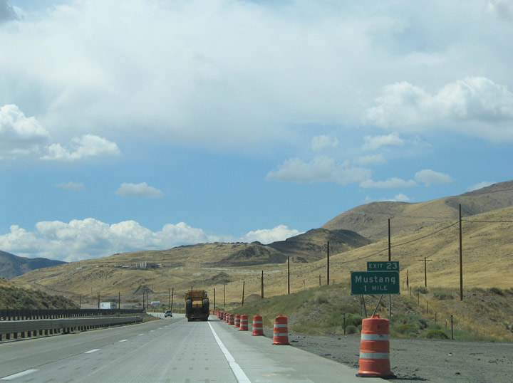
Continuing the descent into Truckee Meadows, the next exit along Interstate 80 west is Exit 23, Mustang Ranch Road. This interchange will also link to the northern frontage road. Mustang Ranch Road stems south as Mustang Road to Peri Ranch Ranch Road and the Storey County line. Photo taken 09/09/05. |
|
Westbound Interstate 80 meets the offramp to the truck check/weigh station/port of entry. Peavine Peak (elevation 8,272 feet above sea level) rises in the background from northwest of Reno. Photo taken 09/09/05. |
|
Interstate 80 westbound reaches Exit 23, Mustang Ranch Road. This split-diamond interchange links the freeway with both Mustang Ranch Road and the Interstate 80 Frontage Road. Mustang was home to the largest brothel in the state of Nevada, the Mustang Ranch. Storey County legalized prostitution in 1971, and thus became the home to Nevada's first licensed brothel. The ranch lied across the Washoe County line (Truckee River) via Mustang Ranch Road south of Interstate 80. The Mustang Ranch went bankrupt in 1990 due to $15 million in back taxes but continued operations until 1999. By 2007, the ranch resumed operation under a separate owner. Photo taken 09/09/05. |
|
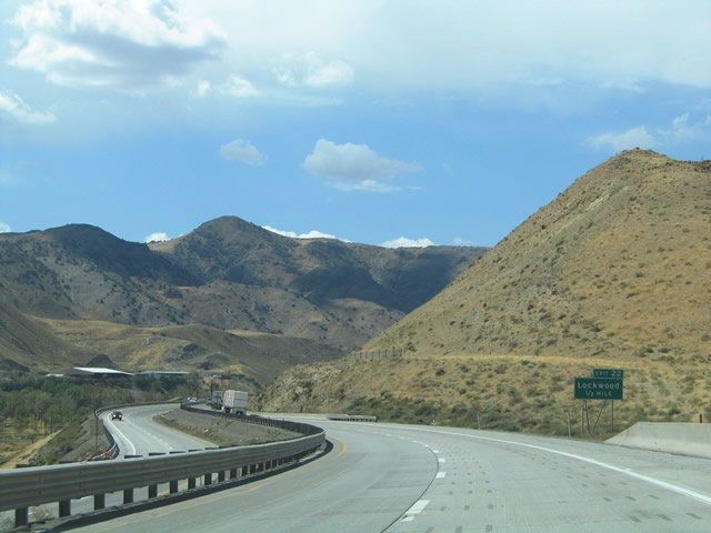
Driving westward toward the settlement of Lockwood, the next interchange along Interstate 80 west is Exit 22, Canyon Road with access to the Truckee River. Lockwood is home to a subdivision along the Truckee River and mobile home park on the adjacent hillside. Photo taken 09/09/05. |
|
A trumpet interchange handles the movements between Lockwood Canyon Way and Interstate 80 at Exit 22. Canyon Road stems south of Lockwood into the adjacent hills toward the main landfill and garbage dump for western Nevada. Photo taken 09/09/05. |
|
|
Interstate 80 leaves Lockwood and approaches the city of Sparks. Sparks was named after the fourth Nevada Governor and cattle baron John D. Sparks. Founded in the early 1900s by the Southern Pacific Railroad, Sparks originally consisted of a switching yard, maintenance plants, and several houses relocated from Wadsworth to the east. The town garnered 3,500 residents by 1906, all railroad employees, contractors, or their families. Sparks remained a railroad town until the 1950s when those operations shifted to Roseville, California. Nuggets casino opened in 1955 and began prospering in Sparks by 1960. Thus the shift of Sparks to an entertainment and employment center much like its neighbor Reno to the west commenced. Today the city skyline blends seamlessly with Reno to the west with the two municipalities competing for business. Photos taken 09/09/05. |
|
Interstate 80 leaves the Truckee River Canyon and enters the city of Sparks. The Union Pacific Railroad line descends from the mountains alongside the freeway as well. Exit 21 serves Greg Street west and Vista Boulevard north, two multi lane divided surface arterials on the outskirts of town. Photo taken 09/09/05. |
|
Westbound Interstate 80 meets Exit 21, Vista Boulevard north and Greg Street west. Vista Boulevard travels north toward Prater Way, BAring Boulevard, and Wedekind. Greg Street parallels Interstate 80 west through Glendale to Rock Boulevard and Reno-Tahoe International Airport. Photo taken 09/09/05. |
|
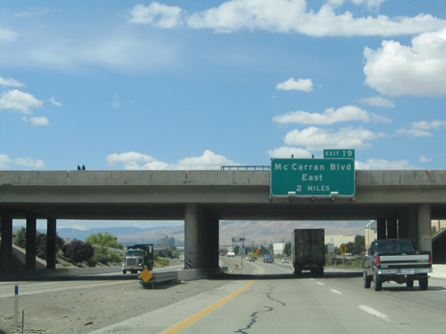
The next two exits along Interstate 80 west are Exit 20, Sparks Boulevard and Exit 19, Nevada 659. Mounted to the Greg Street and Vista Boulevard overhead is the two-mile guide sign for Exit 19, Nevada 659/McCarran Boulevard (former Nevada 650) and Business Loop I-80/Victorian Way west to downtown Sparks (Exit 20 is not signed here). Nevada 659/McCarran Boulevard serves as an arterial belt route around metropolitan Reno and Sparks. The surface arterial carries Nevada 659 to link with U.S. 395 both north and south of downtown. Exit 20 for Sparks Boulevard however represents the next departure point along Interstate 80 westbound. Photo taken 09/09/05. |
|
Westbound Interstate 80 meets Exit 20, Sparks Boulevard. This road travels north from Greg Street to meet Nevada 445/Pyramid Lake Highway and Highland Ranch Parkway north of Sparks. The highway comprises a multi-lane surface arterial between Greg Street and Shadow Lane (Shadow Mountain Park) north of Baring Boulevard. A Union Pacific Railroad spur travels over Interstate 80 westbound ahead of the Exit 20 off-ramp. Photo taken 09/09/05. |
Page Updated August 15, 2012.