|
| Encircling eastern reaches of Steamboat Hills, I-580 passes above the community of Steamboat and continues through a sweeping S-curve to Exit 56 with SR 431 (Mt. Rose Highway). 06/28/14 |
|
| SR 431 constitutes a 24.47 mile route originating at SR 28 at Incline Village at North Lake Tahoe. The state route concludes just east of I-580 at U.S. 395 Alternate (Virginia Street). 06/28/14 |
|
| SR 341 ties into the north end of SR 431 (Mt. Rose Highway) and U.S. 395 Alternate from Geiger Grade Road. The state route travels southeast across the Virginia Range to Virginia City. 06/28/14 |
|
| The broad area of Truckee Meadows spreads into view as I-580 & U.S. 395 turn northward to the Reno city line. 06/28/14 |
|
| The NDOT Steamboat Hills Anti-Icing Facility lines the east side of I-580 just ahead of this overhead for SR 431 (Mt. Rose Highway). Mt. Rose Highway traverses the Carson Range across Mt. Rose Summit. 06/28/14 |
|
| The south end of the U.S. 395 freeway through Reno ended at the parclo interchange (Exit 56) with Mt. Rose Highway until August 2012. 06/28/14 |
|
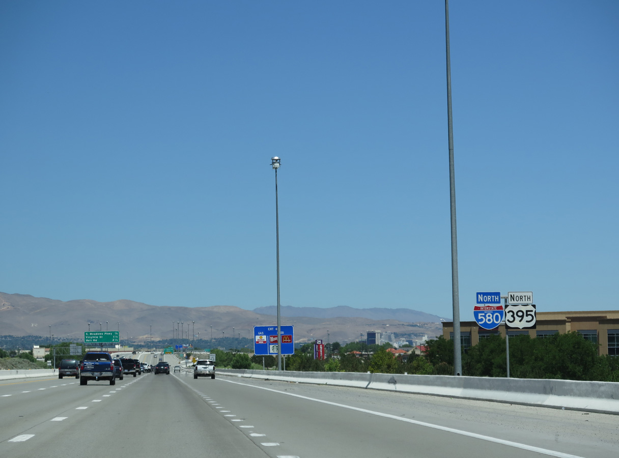
| Interstate 580 & U.S. 395 north reach Exit 56 for SR 431 (Mt. Rose Highway) by The Summit Reno retail area and the sprawling Curti Ranch community. 06/28/14 |
|
| I-580 & U.S. 395 arc northeast between South Valleys Regional Park and The Summit Reno retail complex between SR 431 (Mt. Rose Highway) and U.S. 395 Alternate (Virginia Street) in southern Reno. 06/28/14 |
|
| A partial interchange adds traffic from U.S. 395 Alternate (Virginia Street) north to I-580 & U.S. 395 northbound next. I-580 started from ramps at SR 431 and Virginia Street until the I-580 Freeway Extension opened northbound on August 27, 2012. 06/28/14 |
|
| The Virginia Street on-ramp forms an auxiliary lane north to forthcoming Exit 59. 06/28/14 |
|
| Damonte Ranch Parkway forms an arterial loop with Arrowcreek Parkway southwest from U.S. 395 Alternate (Virginia Street) and east to Steamboat Parkway by the sprawling Double Diamond Ranch Village community. 06/28/14 |
|
| A second set of reassurance markers for I-580 & U.S. 395 stands along the freeway ahead of Exit 59. An undeveloped swath of Truckee Meadows separates I-580 from parallel Steamboat Creek along the east side. 06/28/14 |
|
| Interstate 580 lines up alongside Virginia Street to Exit 61, where Martin Luther King, Jr. Memorial Highway shifts west of U.S. 395 Alternate. 06/28/14 |
|
| Exit 59 is referenced as the first of 12 interchanges for the city of Reno. Home to 245,255 per 2016 Census estimates, the "Biggest Little City in the World" sits at an elevation of 4,505 feet above seal level. Named after Civil War General Jess Reno and established in 1868, the city is the seat of Washoe County. 06/28/14 |
|
| Apartment complexes and business parks populate the adjacent frontage as I-580 & U.S. 395 advance northward from Damonte Ranch Parkway. 06/28/14 |
|
| A diamond interchange (Exit 60) joins I-580 & U.S. 395 with South Meadows Parkway in a quarter mile. The parkway west 0.361 miles to U.S. 395 Alternate (Virginia Street) is SR 426. 06/28/14 |
|
| The auxiliary gained from Exit 59 departs for South Meadows Parkway northbound at Exit 60. A four lane, divided arterial, South Meadows Parkway extends northeast to a number of apartments and condos, the Double Diamond Ranch Village community and the Southeast Connector at the Bella Vista Village development. 06/28/14 |
|
| Curving westerly, I-580 & U.S. 395 travel between additional retail areas and apartment communities along parallel Virginia Street and Gateway Drive. 06/28/14 |
|
| I-580 & U.S. 395 converge with U.S. 395 Alternate (Virginia Street) at a parclo interchange (Exit 61) in a quarter mile. The ensuing stretch north to Neil Road (Exit 63) opened to traffic in 1983. 06/28/14 |
|
| A fourth northbound lane opens from Exit 60 to Exit 61. U.S. 395 Alternate (South Virginia Street) extends north as a commercial arterial along the east side of I-580 & U.S. 395 to SR 659 (McCarran Boulevard) by Meadowood Mall. 06/28/14 |
|
| The U.S. 395 freeway throughout Reno is formally named the Martin Luther King, Jr. (Memorial) Highway. 06/28/14 |
|
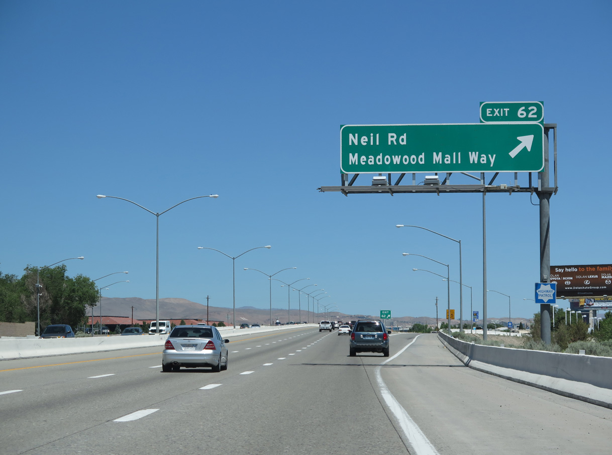
| The forthcoming split diamond interchange (Exit 61) connects I-580 with both Neil Road and Meadowood Mall Way. Meadowood Mall Way links adjacent Virginia Street with the enclosed retail center and parallel Keitzke Lane to the west. 06/28/14 |
|
| Neil Road west becomes Del Monte Lane at a roundabout with Keitzke Lane. Del Monte Lane loops southwest around Anderson Park to Huffaker Lane (SR 671). SR 671 formerly extended north along Del Monte Lane to Virginia Street (former SR 430). 06/28/14 |
|
| Martin Luther King, Jr. Memorial Highway separates retail areas along Virginia Street from the Crystal Lake and Country Estates subdivisions to the west. 06/28/14 |
|
| Traffic departs for Neil Road and Meadowood Mall Way from I-580 & U.S. 395 north at Exit 62. Neil Road encircles the Meadowood Mall areas northeast to SR 659 (McCarran Boulevard). There is no direct access between the freeway and McCarran Boulevard otherwise. 06/28/14 |
|
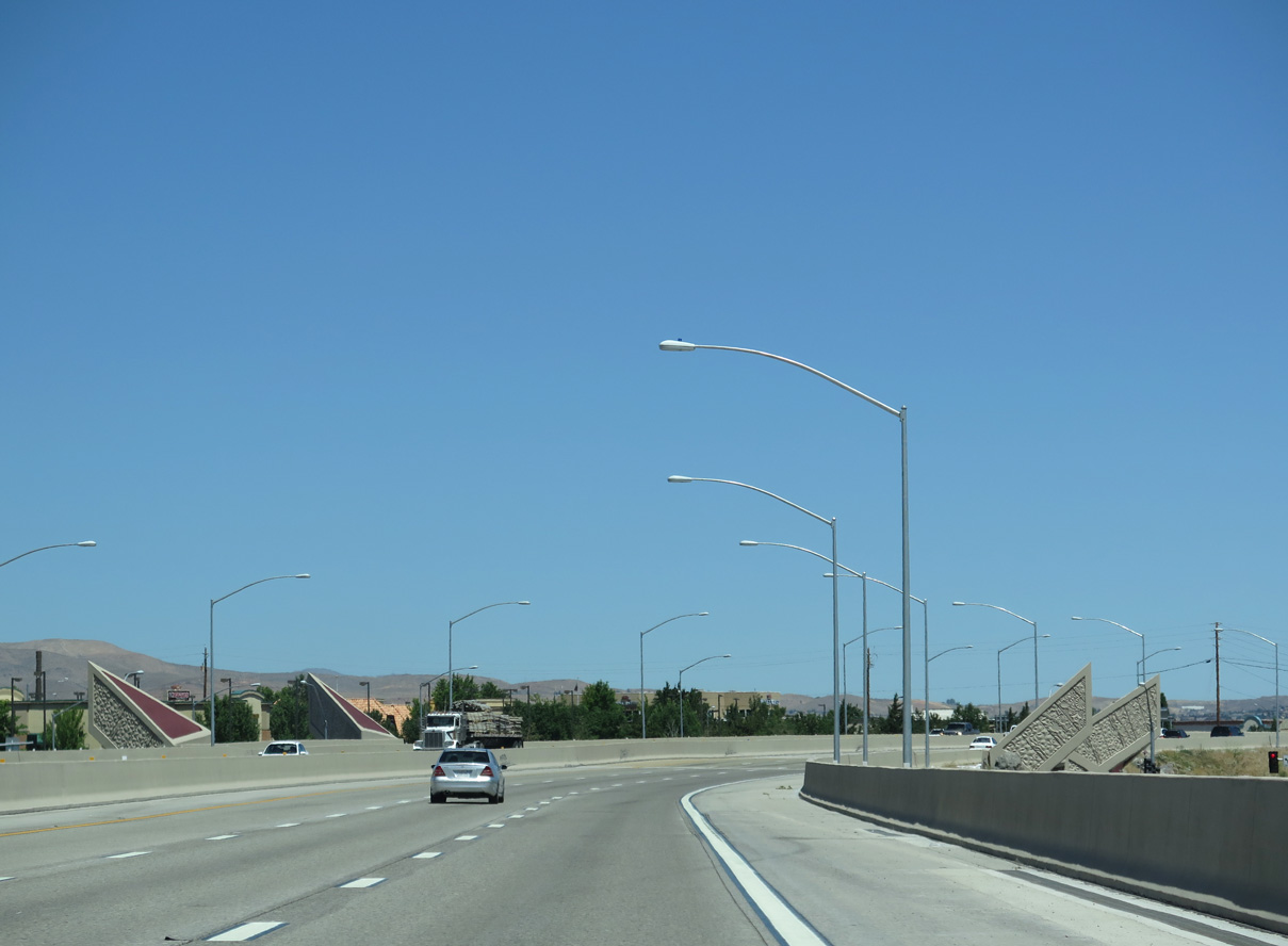
| A $21 million project between June 2010 and November 2012 constructed Meadowood Mall Way below I-580 & U.S. 395. The arterial was built to provide relief along adjacent SR 659 (McCarran Boulevard). Ramps from Neil Road were extended north as frontage roads as well.1 06/28/14 |
|
| A half diamond interchange (Exit 63 southbound) adds traffic from Virginia Street just north of McCarran Boulevard (SR 659) ahead of this shield assembly. 06/28/14 |
|
| Interstate 580 shifts eastward toward Reno-Tahoe International Airport (RNO) by the Reno-Sparks Convention Center to Exit 64 with Moana Lane. 06/28/14 |
|
| Construction completed on November 21, 2012 converted the diamond interchange at Moana Lane into a DDI. Costing $6.9 million, the DDI at Exit 64 was the first built in Nevada.2 06/28/14 |
|
| Moana Lane constitutes a six lane arterial west from I-580 & U.S. 395 to U.S. 395 Alternate (Virginia Street) by Atlantis casino. 06/28/14 |
|
| Moana Lane connects I-580 with parallel SR 667 (Keitzke Lane). Airway Drive arcs southeast from Moana Lane at Neil Road along the west side of RNO Airport. 06/28/14 |
|
| Grand Sierra Resort and Casino appears along the northern horizon as I-580 & U.S. 395 advance northward 0.75 miles to Exit 65 with Plumb Lane (SR 653). 06/28/14 |
|
| Martin Luther King, Jr. Memorial Highway northbound expands to five lanes to the hybrid split-diamond/single point interchange (Exit 65) with Plumb Lane and parallel Villanova Drive. 06/28/14 |
|
| Interstate 580 & U.S. 395 confirming markers posted after the entrance ramp from Moana Lane. 06/28/14 |
|
| A pair of flyovers form a wye interchange connecting the passenger terminal of Reno-Tahoe International Airport (RNO) with I-580 north and from I-580 south. Plumb Lane links northbound with Terminal Way at grade level. 06/28/14 |
|
| Two lanes lower from Interstate 580 & U.S. 395 north for Plumb Lane west between the Meyer and Sierra Meadows neighborhoods to South Virginia Street, and Villanova Lane to Earl Wooster High School. SR 653 overlays Plumb Lane for 0.588 miles between Kietzke Lane (SR 667) and Terminal Way. 06/28/14 |
|
| An eight lane viaduct takes I-580 & U.S. 395 (Martin Luther King, Jr. Memorial Highway) above Plumb Lane (SR 653) and Villanova Drive ahead of the Grand Sierra Resort and Casino. 06/28/14 |
|
| This interchange sequence sign is the first referencing the Spaghetti Bowl interchange with Interstate 80. A parclo interchange (Exit 66) joins I-580 & U.S. 395 with Mill Street next. 06/28/14 |
|
| On-ramps from RNO Airport and the frontage road linking Plumb Lane with Villanova Drive expand Interstate 580 northbound to six overall lanes. 06/28/14 |
|
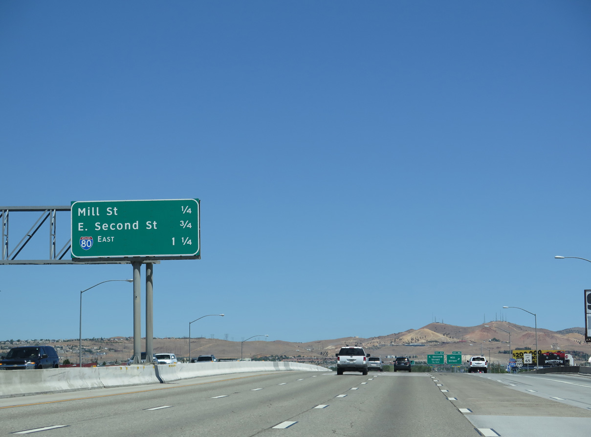
| Exit 66 parts ways with I-580 & U.S. 395 north for Mill Street, an urban arterial leading northwest toward Downtown Reno and southeast to industrial and business parks east of RNO Airport and west of SR 659 (McCarran Boulevard). 06/28/14 |
|
| A seventh northbound lane opens from the Mill Street entrance ramp to the parclo interchange (Exit 67) with SR 648 (East 2nd Street). 07/17/17 |
|
| Interstate 580 & U.S. 395 pass between Reno Sparks Indian Colony and Grand Sierra resort ahead of Exit 67. 07/17/17 |
|
| Back to back off-ramps depart for Interstate 80 in quick succession from I-580 & U.S. 395 north just beyond East Second Street (Exit 67) and the Truckee River. 06/28/14 |
|
| Northbound at Exit 67 for SR 648 (East 2nd Street) in Reno and Glendale Avenue in Sparks. SR 648 measures 2.65 miles between SR 667 (Kietzke Lane) and SR 659 (McCarran Boulevard). 07/17/17 |
|
| Interstate 580 & U.S. 395 (Martin Luther King, Jr. Memorial Highway) span the Truckee River and Kietzke Lane (SR 667) along a S-curve leading into the turbine interchange (Exits 68A/B) with Interstate 80. 07/17/17 |
|
| Painted shields aid motorists as I-580 north approaches a triple lane drop for Interstate 80. 06/28/14 |
|
| Interstate 80 is a transcontinental route spanning the U.S. from San Francisco and Sacramento, California to North Jersey. Traversing remote areas of northern Nevada, I-80 replaced U.S. 40 from Reno-Sparks east to Winnemucca, Elko and West Wendover. 07/17/17 |
|
| The final confirming marker for Interstate 580 north. Prior to October 2012, I-580 was an unmarked route between SR 667 (Exit 62) and I-80. 07/17/17 |
|
| Seven lanes of traffic cross the Truckee River northbound. 168,000 vehicles per day (vpd) were recorded by NDOT on this stretch in 2017. 06/28/14 |
|
| Exit 68A separates from the north end of I-580 for Interstate 80 east across Sparks. 07/17/17 |
|
| Exit 68B follows to a loop ramp for Interstate 80. I-80 passes north of Downtown Reno en route to Verdi and Truckee, California. 07/17/17 |
|
| U.S. 395 continues north along Martin Luther King, Jr. Memorial Highway toward Panther Valley and Cold Springs. Reentering California, U.S. 395 extends northwest to Susanville. 06/28/14 |
Page Updated 07-03-2018.


 North
North