- Welcome to AARoads Forum.


News:
Thank you for your patience during the Forum downtime while we upgraded the software. Welcome back and see this thread for some new features and other changes to the forum.


Recent posts
#1
Weather / Re: What's your weather curren...
Last post by LilianaUwU - Today at 06:58:06 PMIt is April 24 and there is snow on the ground in front of my house.
#2
Pacific Southwest / Re: CA 51/I-80 Business Loop
Last post by ClassicHasClass - Today at 06:50:03 PMDon't forget the W-X.
#3
General Highway Talk / Re: Road-Geeky Things Of The P...
Last post by mgk920 - Today at 06:45:27 PMDropping Banknotes that were entered at www(dot)wheresgeorge(dot)com at tollgates during road trips and seeing where they report back from. 
Mike
Mike
#4
Northeast / Re: New York
Last post by Rothman - Today at 06:35:26 PMPsst. That's because CCs are becoming obsolete with modern data collection methods...
#5
Great Lakes and Ohio Valley / Re: Illinois: Round Mile Mark...
Last post by Rothman - Today at 06:12:12 PMQuote from: paulthemapguy on Today at 04:24:27 PMQuote from: Rothman on April 23, 2024, 10:11:47 PMState maintained =/= state route.
Wat.
It's state-maintained and it's a route. It's a state route. It may not be a State Route, but it's a state route. The adjective "state" and the noun "route" are both correct.
IDOT maintains plenty of roads that are not signed routes. Besides signed numerical designations, there is a separate internal set of numerical designations for various roads across Illinois, state-maintained and otherwise (shown as "FAP", "FAU", etc.). But I don't think that's even what appears at the top of these mile markers. The process of deciding these numbers for the top of these mile markers has always been a mystery to me. Such numbers are usually in the 8000s or 900s (though 316 is an oddball).
Bill Burmaster's (rmsandw) site has covered a plethora of these unsigned state highways: https://www.billburmaster.com/rmsandw/illinois/misc/il900.html
Re-read the OP and understand where this thread started. You could also see what IDOT told me about where one fun marker came from as well (the 316 markers near Charleston on a segment that is not route 316). So, yeah, the "route numbers" on the markers should not be trusted for the actual route designation, like I said at the beginning.
Regarding the top number on the marker, my new friend at IDOT says, "If the route is unmarked, then an alternate or arbitrarily assigned 900-series number is used." In other words, the numbers on the markers are made up and have no correlation to any route designation and are -- to-many-a-roadgeek's-horror -- arbitrary.
Regarding the separate designations that you brought up: "Inventory Key Route" is an interesting designation, but it fulfills a specific purpose: This route designation is mainly to help with functional class of segments and therefore funding eligibility. This designation is simply for the compiling of their 5-year [functional] classification maps. Hence, "FAP" is federal-aid primary, "FAI" is federal-aid interstate, "FAU" is federal-aid urban, and so on, down to "Local" (classified by FHWA as not fed-aid eligible -- not by ownership or maintenance responsibility!). So, Inventory Key Routes are definitely not what we think of when we think of "State Routes," as you put it. They're not even "hidden State Routes," so to speak (i.e., State Routes IDOT just didn't shield for whatever reason).
Furthermore, what else is fun is "Marked Routes" -- the "State Routes" we know and love -- are not an exclusive set of route designations. In other words, all Marked Routes have Inventory Key Route numbering -- well, of course, because all roads have a functional classification. But not all Inventory Key Routes are Marked Routes. So, it's not one or the other. But, Marked Routes are the "State Routes," as you put it, whether actually shielded or not.
So, no, state-maintained does not mean that it's on a State Route, and just because it has an Inventory Key Route doesn't mean that it's on a "hidden State Route" and I would go as far to say not even a real "state route," since you're talking about a GIS programmer's palette, essentially in that data field.
In any matter, I find IDOT's practices to be overly convoluted in this matter...and actually not well-perceived. My new friend at IDOT says that the round markers are used to identify crash locations, but if they don't correlate to anything official in their easily available GIS applications or, worse, only in one esoteric GIS database somewhere that keeps track of such, how efficient is that practice? I mean, NYSDOT has a lot of obsolete reference markers out in the field, but at least you can say that they were actually from a former designation rather than just "arbitrarily" numbered! And, I believe by now, NYSDOT finally has all their GIS data at least in one spot so its Regions don't need their own tailored ArcGIS files...IDOT's hodgepodge is looking behind the times. And, fine, NYSDOT does have various ways of inventorying its roads, but at least when you're talking about route numbers, reference markers and milepoints it all makes sense (except for the ye olde hyphenated route designations that are used to look up ye olde record plans from the medieval ages).

But wait, there's a postscript to this rant -- a codicil, if you will: Although I respect roadgeeks like Bill that dig into what-I'll-call "artifacts" -- old maps, old shields in the field, heck, old DOT docs -- to find out how DOTs operate, there's a lot of speculation or assumptions made out there based on such reading of the tea leaves that are incorrect and found to be such just by sending a DOT an e-mail and eventually getting an actual response.
#6
Northeast / Re: Massachusetts
Last post by SectorZ - Today at 05:25:34 PMI'll ask to pardon my ignorance on this, but are states allowed to willy-nilly toll interstates? I know they've wanted to, and I thought the only way they could was with Lexus lanes. Things like 93 and 95 in NH pre-date their route numbering.
#7
Traffic Control / Re: Erroneous road signs
Last post by roadman65 - Today at 05:18:29 PMhttps://maps.app.goo.gl/v6bm5RFum1f9udjk9
Newport, RI. RI Route 138 turns right here, and not left. Contractor error during the removal of the former interchange.
Newport, RI. RI Route 138 turns right here, and not left. Contractor error during the removal of the former interchange.
#8
General Highway Talk / Re: Most Bestest EZ-Pass Trans...
Last post by paulthemapguy - Today at 04:46:21 PMI know a bunch of out-of-staters that use Illinois Tollway's IPass because of how convenient it is. You can walk up to the customer service desk at any old Jewel grocery store in Chicagoland and request one. There is no fee to pay for the transponder per se; they will ask for $10 up front, but that money will go into your tollway account toward future tolls. There is no monthly fee. They give you all you need to stick the transponder to your vehicle--though I suppose that isn't a difficult feat now that the new transponders they issue ARE just stickers. IPasses are just a daily part of life for a lot of Chicagolanders, so Illinois Tollway knows they would be hearing it if they didn't make it as convenient as possible. Not to be a shill... but you can learn more here: https://www.illinoistollway.com/about-ipass
#9
Great Lakes and Ohio Valley / Re: Illinois: Round Mile Mark...
Last post by paulthemapguy - Today at 04:24:27 PMQuote from: Rothman on April 23, 2024, 10:11:47 PMState maintained =/= state route.
Wat.
It's state-maintained and it's a route. It's a state route. It may not be a State Route, but it's a state route. The adjective "state" and the noun "route" are both correct.
IDOT maintains plenty of roads that are not signed routes. Besides signed numerical designations, there is a separate internal set of numerical designations for various roads across Illinois, state-maintained and otherwise (shown as "FAP", "FAU", etc.). But I don't think that's even what appears at the top of these mile markers. The process of deciding these numbers for the top of these mile markers has always been a mystery to me. Such numbers are usually in the 8000s or 900s (though 316 is an oddball).
Bill Burmaster's (rmsandw) site has covered a plethora of these unsigned state highways: https://www.billburmaster.com/rmsandw/illinois/misc/il900.html
Here are a few I have found in the wild:

IL-8677 by Paul Across America, on Flickr
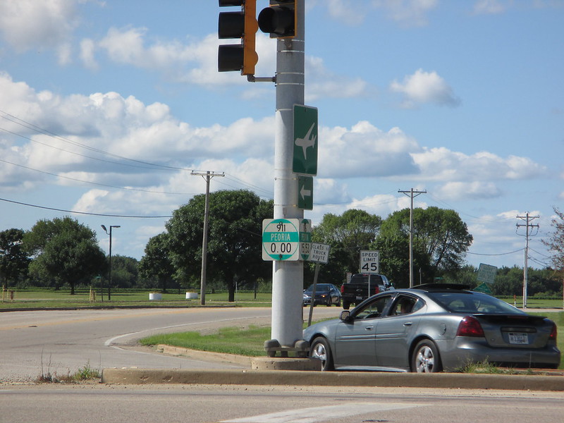
IL-905WR-I-474 by Paul Across America, on Flickr
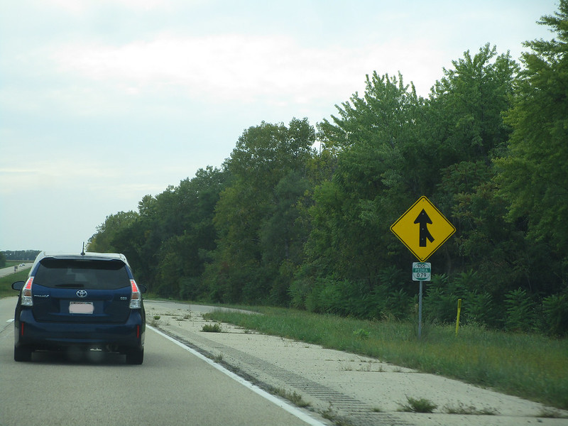
IL-911-0MI by Paul Across America, on Flickr

IL-919 by Paul Across America, on Flickr
#10
Traffic Control / Re: Unique, Odd, or Interestin...
Last post by Amaury - Today at 04:12:05 PMThis is on US Route 2 at the Idaho and Montana border. I don't think I've seen a sign that actually said state line: https://maps.app.goo.gl/ZbUjEXdFeByQtAuR8
Much more commonly, it's a unique welcome to the state sign, as seen farther up in that capture. Sometimes, it's also a generic "Entering State," like at the Washington and Oregon state lines in a couple places, such as the Interstate 5 bridge between Vancouver and Portland.
That Idaho sign is also kind of wrong by having "standard" in there. Just have Pacific Time Zone, like the Montana side does in the other direction, except it's Mountain instead of Pacific. And what's with the hyphens?