- Welcome to AARoads Forum.


News:
Thanks to everyone for the feedback on what errors you encountered from the forum database changes made in Fall 2023. Let us know if you discover anymore.


Recent posts
#11
Mountain West / Re: I-40/US 93 West Kingman In...
Last post by Plutonic Panda - Today at 12:50:36 AMQuote from: vdeane on April 24, 2024, 09:12:17 PMAZDOT needs to fucking get with it, IMHO.Quote from: SSR_317 on April 24, 2024, 02:06:34 PMYou mentioned the whole corridor at the end of your post and seemed to imply that this interchange was the only thing preventing I-11 from being signed from I-40 to the Nevada border. To get that finished, they would also need to address the stuff north of I-40, and quite a few more things to the south, not "just" the ones you listed.Quote from: vdeane on April 24, 2024, 12:53:43 PMAnd what of the part north of this interchange? There's even a traffic light.That signalized intersection will (eventually) be replaced by an interchange. I was talking about the part from US 95's East Junction with I-40 south through Wikieup to just north of Wickenburg.
#12
Southeast / Re: Interstate 73/74
Last post by sprjus4 - Today at 12:42:42 AMQuote from: jdunlop on April 24, 2024, 08:42:15 PMWhy not loop ramps with C/D ramps?Quote from: sprjus4 on April 22, 2024, 11:00:12 PMQuote from: cowboy_wilhelm on April 22, 2024, 10:19:47 PMI agree... I can understand the ramps for redundancy, but 2 lane flyovers seem a bit excessive. Well... at least they will never be congested!Quote from: ARMOURERERIC on April 11, 2024, 08:37:28 PMI don't get the need for full access at all 3 interchanges.
I was wondering this as well. Who is going from I-40 westbound to I-74 westbound or eastbound, or I-74 (either direction) to I-40 EB? There are no plans to continue the beltway south/west, right? Seems like a massive interchange for very little traffic.
FHWA requires full movement at all Interstate interchanges (with very few exceptions) hence the redundant ramps.
NCDOT standard design for flyovers is two lanes because widening the structure later is nearly impossible.
#13
General Highway Talk / Re: Roads that you have been o...
Last post by cwf1701 - Today at 12:20:45 AMThe only other bridge i was on before a disaster was the I-94/Middlebelt road bridge before August 1987. While the Bridge was not destroyed in the crash of Northwest 255, the bridge took some minor damage from the crash and was replaced during reconstruction of the ramps around Metro Airport in the 90s.
#14
Off-Topic / Re: Technology Random Access T...
Last post by noelbotevera - Today at 12:20:13 AMQuote from: vdeane on April 22, 2024, 08:56:08 PMQuote from: Scott5114 on April 22, 2024, 03:31:23 AM(when I got to the end of K&R, I was like...wait, that's it? that's the whole language?)When I was in college, that book was (only half) jokingly referred to as "the Bible". I still have it after all these years, even though at this point the odds of me doing anything in C are slim to none. The C language does have a certain elegance that many other languages lack.
Quote from: Scott5114 on April 22, 2024, 10:27:16 PMI pull it out and read it cover to cover from time to time, even when I'm not planning on writing any C any time soon. So many modern languages (especially the two I write the most code in, Perl and PHP) lean so heavily on what C does, that it's helpful to refresh my knowledge of C even if I'm not writing in it.Hey, I actually printed out this book to self study! I'm amazed at how it also teaches you to be a better programmer (like avoiding magic numbers -- replace fixed constants with symbols, so it's easier to change these constants later) while teaching you the language. Obviously some of it is outdated, namely anything involving floats being simplified with C99.
I think one of the neatest tricks with (Unix like) C is how basic system calls like read(), write(), open(), and close() can be used for both files and network sockets. What sort of witchcraft is being performed to make a network socket behave like a file? Makes file transfer really freaking easy in C.
#15
Welcome! / Re: Forum functionality issues
Last post by rickmastfan67 - April 24, 2024, 11:40:50 PMQuote from: formulanone on April 24, 2024, 02:39:54 PMI found a silly item in my profile that won't seem to go away.
The username info in the Skype field doesn't seem to fully disappear; you can remove it, but then it eventually comes back after any profile changes.
I forget if I ever actually filled in that information because I haven't used Skype in over 10 years.
I just manually removed it for you. Hopefully this will stick.

#16
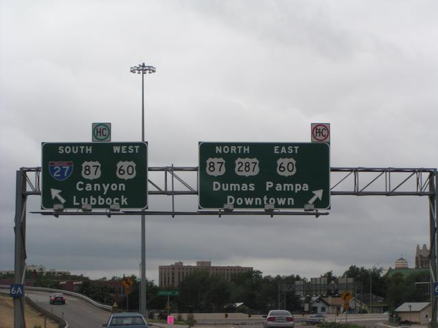
Traffic Control / Re: Unique, Odd, or Interestin...
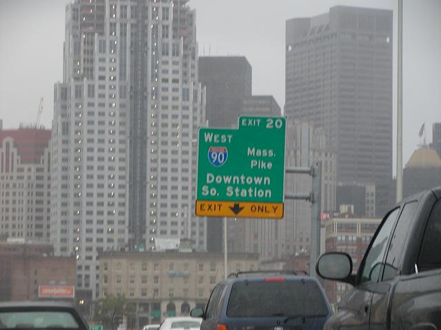
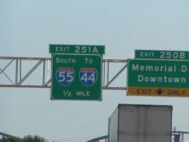
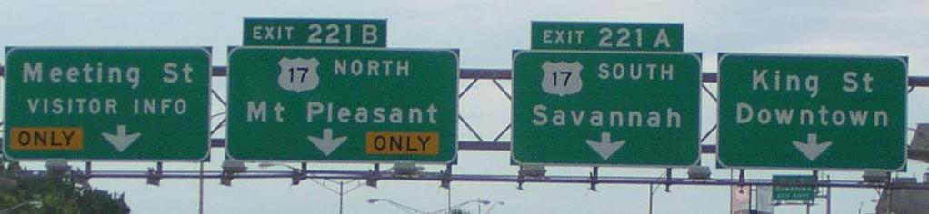
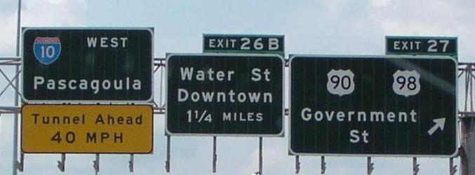
Last post by Jim - April 24, 2024, 10:41:50 PMA few generic "downtown" exits of which I have taken pictures. Only searched up to 2003.
Boston. October 12, 2002.
St. Louis. July 20, 2003.
Charleston. August 22, 2003.
Mobile. August 22, 2003.
Fort Worth. August 31, 2003.
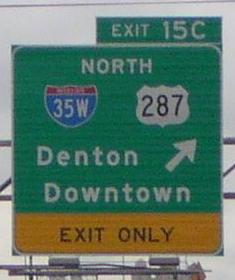
Amarillo. August 31, 2003.
Boston. October 12, 2002.
St. Louis. July 20, 2003.
Charleston. August 22, 2003.
Mobile. August 22, 2003.
Fort Worth. August 31, 2003.
Amarillo. August 31, 2003.
#17
Traffic Control / Re: Unique, Odd, or Interestin...
Last post by freebrickproductions - April 24, 2024, 10:30:21 PMQuote from: Scott5114 on April 24, 2024, 12:22:13 AMQuote from: 74/171FAN on April 23, 2024, 06:13:48 PM
So you're allowed to trespass before 10 pm? That wouldn't be trespassing if it's allowed, would it?

Also, am I allowed to go there at 12 AM the following day? If not, then what about 7 AM the following day? Am I just banned from ever going again after it passes 10 PM the first time I'm ever there?
Quote from: Amaury on April 24, 2024, 04:12:05 PMThis is on US Route 2 at the Idaho and Montana border. I don't think I've seen a sign that actually said state line: https://maps.app.goo.gl/ZbUjEXdFeByQtAuR8
Much more commonly, it's a unique welcome to the state sign, as seen farther up in that capture. Sometimes, it's also a generic "Entering State," like at the Washington and Oregon state lines in a couple places, such as the Interstate 5 bridge between Vancouver and Portland.
I've seen similar before down here in the southeast, mostly along more minor roads/highways that have the state line marked. A few examples:
https://www.google.com/maps/@34.9908697,-86.5712665,3a,15y,192.49h,88.87t/data=!3m6!1e1!3m4!1s0I4nGKOl4pxl_ZGO2suIlg!2e0!7i16384!8i8192?entry=ttu
https://www.google.com/maps/@34.9921757,-86.7217186,3a,15y,34.22h,84.71t/data=!3m6!1e1!3m4!1sb_uGfnccNJOQTzLBGYn16g!2e0!7i16384!8i8192?entry=ttu
https://www.google.com/maps/@34.867395,-85.5846465,3a,15y,91.63h,89.55t/data=!3m6!1e1!3m4!1sDI-Tz36k49NaRxHXrvxr2Q!2e0!7i16384!8i8192?entry=ttu
https://www.google.com/maps/@30.9983885,-85.4078137,3a,15y,201.09h,90.38t/data=!3m6!1e1!3m4!1s-Xk7BzNlqUEZYryBlnp65A!2e0!7i16384!8i8192?entry=ttu
https://www.google.com/maps/@33.8857345,-88.2298417,3a,15y,302.1h,86.11t/data=!3m6!1e1!3m4!1sebhCyhSdLOB39cSEIfe73Q!2e0!7i16384!8i8192?entry=ttu
#18
General Highway Talk / Re: Road-Geeky Things Of The P...
Last post by freebrickproductions - April 24, 2024, 10:24:12 PMQuote from: dlsterner on April 24, 2024, 01:18:02 AMQuote from: SEWIGuy on April 23, 2024, 09:57:07 PMIf you want to see what P13 is up to...
https://www.nonleaguematters.co.uk/forums/threads/the-poiponen13-thread.12558/
They even created his own topic! It all reads very familiar.
Interesting that when P13 was on this board, they branched off into football and "floorball" scheduling -- but on that board, P13 never branched off into road geek stuff(I will admit that I didn't read every post)
TBF, I seem to recall him mentioning (just before his ban here) that he wasn't "as interested in roads anymore" or something like that.
#19
Traffic Control / Re: Guess the State Route Chal...
Last post by wriddle082 - April 24, 2024, 10:16:05 PMNC 24
#20
Mid-Atlantic / Re: Francis Scott Key Bridge (...
Last post by Henry - April 24, 2024, 10:02:30 PMQuote from: 1995hoo on April 24, 2024, 11:21:59 AMMore like aQuote from: Alex on April 24, 2024, 10:03:43 AMUntil there is something formal announced about a name change for a replacement bridge, let's move on from that speculation, Francis Scott Key's legacy, and also philosophical concepts involving demographics.
Half an hour later....Quote from: RobbieL2415 on April 24, 2024, 10:34:21 AMRename it to the George Herman Ruth Bridge.
The Babe was born in Baltimore.
Not sure whether that warrants aor a
.

But as Alex said, there's no word on when the new bridge will have a different name, so let's just assume that it'll also be called the Key Bridge. After all, President Biden did say they were going to rebuild it, so there we have it.