
Interstate 66 crosses into Washington, DC from the independent city of Arlington. From the official county web site in 2004,
Arlington County was originally part of the ten mile square parcel of land surveyed in 1791 to be the Nation's Capital. Then known as "Alexandria County of the District of Columbia," it included what is now Arlington County plus part of the neighboring city of Alexandria. The U.S. Congress returned that portion of the land to the Commonwealth of Virginia following a referendum among its citizens. In 1870, the City of Alexandria and Arlington officially separated their jurisdictions, and in 1920, the name Arlington County was adopted to end confusion with the City of Alexandria.There are no cities or towns within Arlington County, and by law the County cannot be divided for the establishment of separate jurisdictions.
 East
East
08/04/13

08/04/13

Forthcoming SR 243 (Nutley Street) connects Interstate 66 with U.S. 29 (Lee Highway) to the south and with SR 123 (Maple Avenue) in Vienna to the north.
08/04/13

66 Outside the Beltway Express Lanes construction modifies the cloverleaf interchange with SR 243 (Nutley Street) into a DDI.
08/04/13

The roadways of I-66 separate through the exchange with SR 243 to accommodate the Vienna/Fairfax-GMU Station along Metro's Orange Line.
08/04/13

Continuing east from Vienna, Interstate 66 advances to the major interchange with I-495 (Capital Beltway). Separate ramps connect with I-495 north and the I-495 Express Lanes.
08/04/13

All lanes along Interstate 66 switch to the tolled 66 Inside the Beltway Express Lanes beyond the exchange with I-495. The managed lanes operate during weekday mornings in place of what was an HOV-2 restriction.
08/04/13

The tolled I-495 Express Lanes accompany both directions of the Capital Beltway north to George Washington Memorial Parkway and south to the Springfield Interchange with I-95/395.
08/04/13

08/04/13

08/04/13

Encircling Washington, D.C., I-495 (Capital Beltway) arcs northeast to I-270 for Frederick and east to Silver Spring, Maryland. The beltway southeast connects with I-95 southbound to Fredericksburg and Richmond.
08/04/13

The Capital Beltway serves as major commuter route, connecting the suburbs of Tysons Corner to the north with the city of Alexandria to the southeast.
08/04/13

U.S. 50 provides an alternative, albeit slow and often congested, to Interstate 66 between I-495 via Exit 64A and the Theodore Roosevelt Bridge into Washington, D.C.
08/04/13

08/04/13

Dunn Loring-Merrifield Station falls between the roadways of I-66 by Gallows Road (SR 650).
08/04/13

Two lanes leave I-66 east for I-495 (Capital Beltway) south to I-95 for Richmond and the Woodrow Wilson Bridge east from Alexandria to Oxon Hill, Maryland.
08/04/13

Exit 64B follows from I-66 east to I-495 north for Tysons Corner and I-95 north to Baltimore, Maryland. This is the second and last interstate junction along Interstate 66.
08/04/13

The left exit for the I-495 Express Lanes provides access to both directions of the managed roadway.
08/04/13

The Orange Metro Line continues along the median of Interstate 66 toward the independent city of Falls Church.
08/04/13

The first exit within the Beltway is the exchange with SR 7 (Leesburg Pike) east to Falls Church and west to Tysons Corner.
08/04/13

08/04/13

The West Falls Church-VT/UVA Metro Station precedes the wye interchange bringing SR 267 (Dulles Toll Road) east onto Interstate 66.
08/04/13

The last six exits along Interstate 66 eastbound in Virginia serve the city of Arlington.
08/04/13

I-66 stays just outside the independent city of Falls Church, passing close by at the off-ramp (Exit 68) for Westmoreland Street.
08/04/13

Exit 69 quickly follows Westmoreland Street for Fairfax Drive at U.S. 29 (Lee Highway) and SR 237 (Washington Boulevard).
08/04/13

U.S. 29 (Lee Highway) shifts north of I-66 between Exit 69 and Exit 72 at Cherrydale in Arlington. SR 237 roughly parallels U.S. 29 to the south, heading east to Ballston in Arlington before joining U.S. 50 near Arlington National Cemetery.
08/04/13

Confirming marker posted beyond the Sycamore Street entrance ramp within the city of Arlington.
08/04/13

The next exit along eastbound I-66 is with Fairfax Drive east to SR 120 (Glebe Road) at SR 237 in Ballston, Arlington.
08/04/13

Exit 71 is a wye interchange joining I-66 east with Fairfax Drive (SR 237) east into the Ballston business district.
08/04/13

A half diamond interchange joins SR 120 (Glebe Road) with I-66 east. Exit 72 follows with U.S. 29 (Lee Highway) adjacent to Spout Run Parkway.
08/04/13

A parking deck spans Interstate 66 between the N Stafford Street and N Quincy Street overpasses.
08/04/13

08/04/13

U.S. 29 (Lee Highway) constitutes a four to six lane divided boulevard west to Cherrydale and east by Lyon Village. Spout Run Parkway branches north from U.S. 29 to George Washington Parkway.
08/04/13

I-66 arcs north of U.S. 29 and meets Lee Highway again at the ensuing exit in 0.75 miles. U.S. 29 splits into a couplet alongside the freeway to Rosslyn.
08/04/13

A split diamond interchange (Exit 73) joins I-66 with U.S. 29 between N Scott Street and N Lynn Street in Rosslyn. U.S. 29 turns north across the Francis Scott Key Memorial Bridge to Georgetown in Washington, DC.
08/04/13

The final exit along I-66 east within the Commonwealth of Virginia is with the SR 110 freeway south to the Pentagon. SR 110 links with U.S. 1 north from Crystal City and Ronald Reagan Washington National Airport (DCA).
08/04/13

08/04/13

SR 110 extends from Interstate 66 and Wilson Boulevard at Rosslyn southward along the eastern edge of Arlington National Cemetery to Interstate 395.
08/04/13

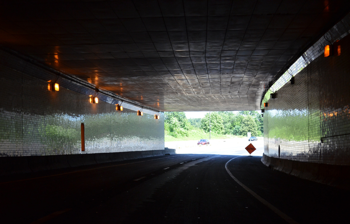
The speed limit for Interstate 66 decreases from 55 to 45 miles per hour as the freeway passes through a cut and cover tunnel below Gateway Park.
08/04/13

08/04/13
08/04/13

Interstate 66 emerges from the tunnel beyond U.S. 29 (N Lynn Street) and turns south to the wye interchange (Exit 75) with SR 110. SR 110 runs along the east side of the Pentagon to I-395 and U.S. 1 by Pentagon City and Crystal City.
08/04/13

Interstate 66 curves southeast from the split with SR 110 at Exit 75 to the Theodore Roosevelt Bridge into Washington.
08/04/13
 East
East
The Arlington Memorial Bridge (former U.S. 240) over the Potomac River comes into view to the south as U.S. 50 combines with Interstate 66 east from Arlington Boulevard.
08/04/13

The Theodore Roosevelt Bridge accommodate seven overall lanes of traffic along I-66/U.S. 50 between Arlington and D.C.
08/04/13

Sources:
- "New Diverging Diamond Interchange Opens This Weekend - Interchange at I-66 and Route 15 first of its kind in northern Virginia." VDOT, news release. January 26, 2017.
Photo Credits:
08/04/13 by AARoads
Connect with:
Interstate 495 / Capital Beltway
U.S. 29
State Route 234
Page Updated 06-29-2020.