Interstate 490 Eastbound - Downtown to Victor
| Interstate 490 East | |
|---|---|
 |
Interstate 490 leaves downtown and the confluence with the Inner Loop freeway for the Exit 17 diamond interchange with Goodman Street. Alexander and Averill Streets pass over the freeway one quarter mile ahead of the Goodman Street off-ramp. Goodman Street travels north from Elmwood Avenue and Highland Park to Interstate 490 at Clinton Avenue and Richard Street. Photo taken 05/10/05. |
 |
The right-hand lane, gained from the Inner Loop and New York 15 on-ramp, forms the exit-only lane for Goodman Street. Goodman Street provides a main north-south route through east Rochester neighborhoods. The street travels north to East Main Street, and again from East Main Street to Ridge Road at the Irondequoit Mall. Photo taken 05/10/05. |
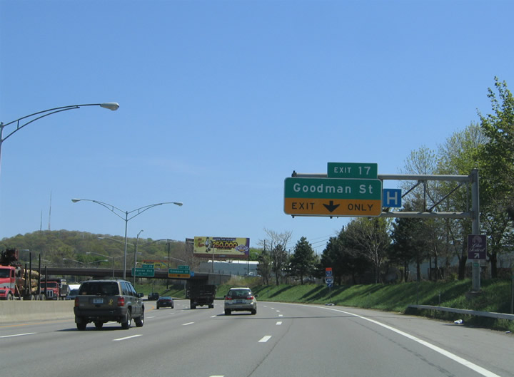 |
NYSDOT really wants drivers to know about the Goodman Street exit, so there are four signs heralding the exit-only off-ramp. Photo taken 05/10/05. |
 |
Exit 17 leaves Interstate 490 east at the Meigs Street over crossing. Goodman Street ends 1.25 miles to the south at Elmwood Street and intersects New York 96 (East Avenue) less than a mile to the north. Photo taken 05/10/05. |
 |
Arriving at the end of the Exit 17 off-ramp at Goodman Street. Photo taken 07/02/05. |
 |
An auxiliary lane carries motorists onto Interstate 490 from Goodman Avenue and off to New York 31 (Monroe Avenue) at Exit 18. New York 18 follows Monroe Avenue east from Court and Broad Streets in downtown to Brighton and points southeast. Photo taken 05/10/05. |
 |
Exit 18 ascends from the six-lane freeway to New York 31 (Monroe Avenue) via Field Street. Monroe Avenue continues southeast from Interstate 490 to Cobbs Hill Park and Twelve Corners, the Brighton village center. Photo taken 05/10/05. |
 |
Attached to the New York 31 (Monroe Avenue) over crossing is the first sign for Exit 19 (Culver Road). Culver Road comprises a through street between Monroe Avenue and Irondequoit through east Rochester. Photo taken 05/10/05. |
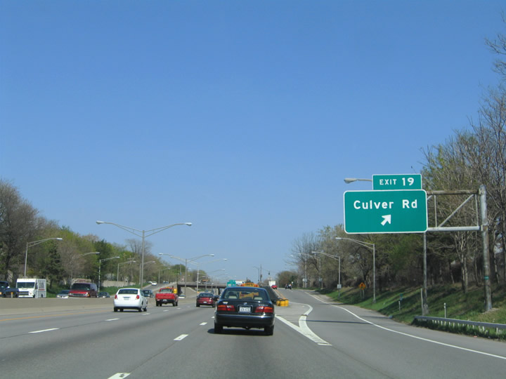 |
The Exit 19 diamond interchange lies north of Cobbs Hill Park. Culver Road ends at Monroe Avenue to the south and meets Clifford and Empire Boulevards 2.5 miles to the north. Photo taken 05/10/05. |
 |
Interstate 490 continues east as a depressed freeway toward Winton Road (Exit 20) and the Can of Worms interchange with Interstate 590 & New York 590 (Exit 21). Winton Road skirts the eastern reaches of Rochester between Interstate 490 and New York 404 (Empire Boulevard). Photo taken 05/10/05. |
 |
Interstate 490 briefly gains a grassy median on the approach to Winton Road (Exit 20). Winton Road travels southwest from the freeway to Twelve Corners in Brighton, where it meets New York 31 (Monroe Avenue) and Elmwood Avenue. Photo taken 05/10/05. |
 |
Eastbound at the Exit 20 half-diamond interchange with Winton Road. Winton Road overall travels between Henrietta and Irondequoit Bay. The road meets New York 96 (East Avenue), University Avenue, and Blossom Road within one half mile of Interstate 490. Photo taken 05/10/05. |
 |
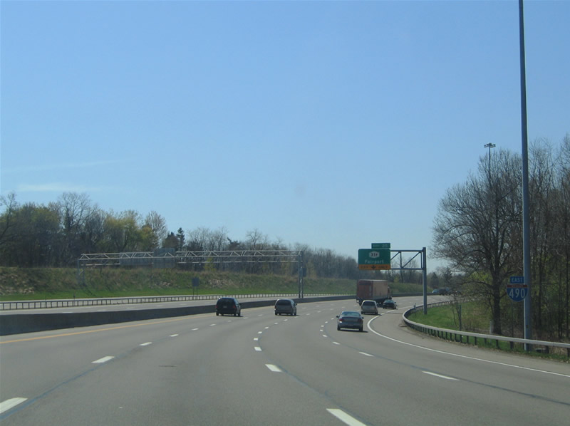
A large Diagrammatic overhead advises motorists of the Exit 21 ramp configuration at the Can of Worms interchange with Interstate 590 south and New York 590 (Sea Breeze Expressway) north. The Can of Worms, so named because of the varying directional ramps between the three freeways, replaced two independent tri-level stack interchanges during its construction in the early 1990s. Exit 21 represents the return of the Outer Loop freeway via Interstate 590 and beginning of the Sea Breeze Expressway spur to New York 104 and Irondequoit Bay. Photo taken 05/10/05. |
 |
Interstate 490 maintains six overall lanes through the Can of Worms interchange. A pair of lanes depart via Exit 21, carrying movements to Interstate 590 south and New York 590 north in unison. Interstate 590 travels southwest around Brighton to Interstate 390 north of Henrietta. New York 590 heads north to New York 104, an east-west freeway between north Rochester and Webster. Photo taken 05/10/05. |
 |
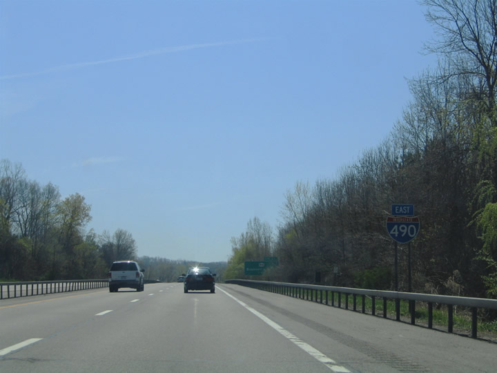
Traveling the Exit 21 off-ramp to its partition into ramps for Interstate 590 south and NY 590 north. The Sea Breeze Expressway derives its name from the Sea Breeze community at New York 590's north end. The freeway portion continues Interstate 590's exit number scheme to NY 104. North of there NY 590 downgrades into a surface boulevard. I-590 is the eastern half of the Outer Loop Freeway between I-390 and I-490. It provides a bypass route of downtown and also serves commuter interests from Henrietta and Brighton. Photo taken 05/10/05. |
 |
One half mile west of the half diamond interchange (Exit 22) with Penfield Road on Interstate 490 east within the Can of Worms interchange. Penfield Road begins from parallel New York 96 (East Avenue) and heads east across Interstate 490 to the suburb of Penfield. Photo taken 05/09/05. |
 |
Drivers from Interstate 590 north and New York 590 (Sea Breeze Expressway) south merge onto Interstate 490 in unison ahead of the Clover Street overpass. The lane gained from the Exit 21 forms the exit-only lane to Penfield Road. Penfield Road ends at New York 96 (East Avenue) adjacent to its intersection with New York 65 (Clover Street). Penfield Road east passes under the New York Central Railroad line and intersects North Landing Road to the east. Photo taken 05/09/05. |
 |
Exit 22 leaves Interstate 490 east for Penfield Road. Penfield Road east continues as a through road 2.25 miles to Panorama Trail South, but in name along New York 441 east of Linear Park. New York 441 (Linden Avenue) interchanges with Interstate 490 at Exit 23. Photo taken 05/09/05. |
 |
Interstate 490 passes under Penfield Road 0.75 miles ahead of the New York 441 (Linden Avenue) diamond interchange (Exit 23). New York 441 travels along a four-lane expressway east from New York 96 (East Avenue) to the merge with Penfield Road. Photo taken 05/09/05. |
 |
New York 441 ends at New York 96 (East Avenue) at Elmwood Avenue to the west and at New York 350 (Ontario Center Road) near Walworth to the east. Sound walls rise along the Interstate 490 frontage through the east Rochester metropolitan area. Photo taken 05/09/05. |
 |
South Landing Road passes over Interstate 490 ahead of the Exit 23 off-ramp to New York 441 (Linden Avenue). Elmwood Avenue travels west from the New York 441 terminus to Brighton and south Rochester. Photo taken 05/09/05. |
 |
Next in line for eastbound travelers is the Exit 24 trumpet interchange serving East Rochester. East Rochester lies at the crossroads of New York 153 (Washington Street) and New York 31F (Fairport Road). Photo taken 05/09/05. |
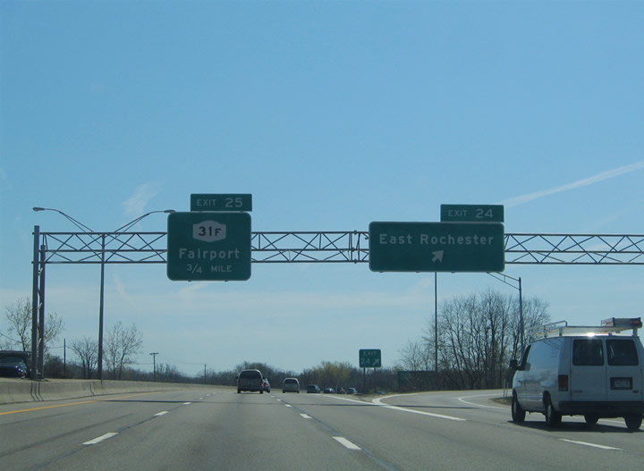 |
Drivers bound for West Commercial Street into the Village of East Rochester depart Interstate 490 east at Exit 24. West Commercial Street travels east to NY 153 (South Washington Street) and Main Street. Photo taken 05/09/05. |
 |
Interstate 490 bends southward on the approach to Fairport Road (Exit 25). The freeway gains an auxiliary lane between West Commercial Street and the New York 31F off-ramp. Photo taken 05/09/05. |
 |
NY 31F (Fairport Road) converges with I-490 at a parclo interchange (Exit 25). The state route spurs east from NY 96 (East Avenue) to East Rochester, Fairport, Macedon and NY 31. Photo taken 05/09/05. |
 |
Exit 25 loops down to New York 31F (Fairport Road) from Interstate 490 east. New York 31F ends at New York 96 (East Avenue) nearby to the west and intersects New York 153 (South Washington Street) to the east. The exit serves St. John Fisher and Nazareth Colleges. Photo taken 05/09/05. |
 |
A closer look at one of the Interstate 490 reassurance shields with series B Highway Gothic Font. The marker lies between Exits 25 and 26. Photo taken 05/09/05. |
 |
New York 31 (Palmyra Road) heads southeast from Pittsford across Interstate 490 at Exit 26. The state route crosses paths with Interstate 490 at Exits 13 and 18 near downtown as well. Photo taken 05/09/05. |
 |
Interstate 490 eastbound at Exit 26 for NY 31 (Palmyra Road). NY 31 travels 1.5 miles west to Pittsford and 13 miles east to Palmyra. Photo taken 05/09/05. |
 |
Continuing southeast along Interstate 490 toward the Ontario County line and Victor. Photo taken 05/09/05. |
 |
New York 96 parallels Interstate 490 east from downtown Rochester to Pittsford and Victor. The state route finally sees direct access with the freeway at Exit 27 at Bushnell's Basin. Photo taken 05/09/05. |
 |
Interstate 490 passes over Kreag Road ahead of the trumpet interchange connector (Exit 27) with adjacent NY 96 (Pittsford-Victor Road). NY 96 follows Jefferson Road south from Pittsford to Thornell Road at Bushnell's Basin. From there the state route parallels I-490 southeast to Garnsey Road, Park Road and Exit 28. Photo taken 05/09/05. |
 |
A large New York Thruway trailblazer advises motorists of the upcoming connection with Exit 45 of Interstate 90. Photo taken 05/09/05. |
 |
NY 96 (Pittsford-Victor Road) meets Interstate 490 again at the half diamond interchange at Exit 28. Pittsford-Victor Road continues east underneath the freeway to NY 250 (Moseley Road) and the Ontario County line nearby. Photo taken 05/09/05. |
 |
Eastbound at the Exit 28 off-ramp to New York 96 (Pittsford-Victor Road). New York 96 splits with the High Street Extension after Turk Hill Road with both roads continuing south to Victor. Photo taken 05/09/05. |
 |
Interstate 490 east again expands to three lanes after the Ontario County line. A truck inspection station resides along the freeway in both directions between Exits 28 and 29. Photo taken 05/09/05. |
 |
The truck inspection station is the same thing as a truck weigh station in most other states and a truck check station in Nevada. Photo taken 05/09/05. |
 |
Signs advise motorists of the impending toll plaza for the New York Thruway entrance beyond Exit 29. They also indicate that Exit 29 is the last exit before the toll. Photo taken 05/09/05. |
 |
New York 96 continues to intertwine with Interstate 490, meeting the freeway again at Exit 29. Interests to the Town of Victor should use New York 96 (Victor-Pittsford Road) east from Exit 29. Photo taken 05/09/05. |
 |
Two lanes of Interstate 490 default into the trumpet interchange with Interstate 90, the right-hand lane departs for New York 96 to Victor. Victor grew as part of the Rochester metropolitan area in conjunction with the New York Thruway and later Interstate 490. Construction for the Thruway began on October 25, 1946 at Victor.1 Photo taken 05/09/05. |
 |
Interstate 490 eastbound at the Exit 29 interchange with New York 96. New York 96 heads 3.5 miles southeast to the Victor town center and five miles to East Victor. The state route parallels the New York Thruway east to Waterloo. Photo taken 05/09/05. |
 |
The freeway passes underneath Victor-Pittsford Road ahead of the Exit 45 toll plaza for the entrance onto the New York Thruway. Photo taken 05/09/05. |
 |
 |
Entering the Victor toll plaza for the New York Thruway on Interstate 490 east. There are no end signs posted for the freeway conclusion. Photos taken 05/09/05. |
 |
A small guide sign partitions traffic into the respective ramps for Interstate 90. Interstate 90 west travels 72 miles to Buffalo while eastbound reaches the capital city in 209 miles. Albany, Buffalo, and New York are the only control cities used for the New York Thruway mainline these days. Photo taken 05/09/05. |
 |
Interstate 90 shields direct motorists onto the New York Thruway east and west. Interstate 90 west travels 12 miles to Interstate 390 at Henrietta and 40 miles to Batavia. The toll road eastbound continues 77 miles to Syracuse and 129 miles to Utica. Photo taken 05/09/05. |
 |
 |
Sources:
- Victor, NY - Departments.
http://www.victorny.org/ departments.asp?cat=12&ID=36Town of Victor web site.
Page Updated August 18, 2009.
|
About Contact Glossary |
In The News Testimonials Interstate Guide |
Social Media:
 |
|
© 2000-23 AARoads.com | All Rights Reserved | Privacy Policy / Terms of Use
|
||