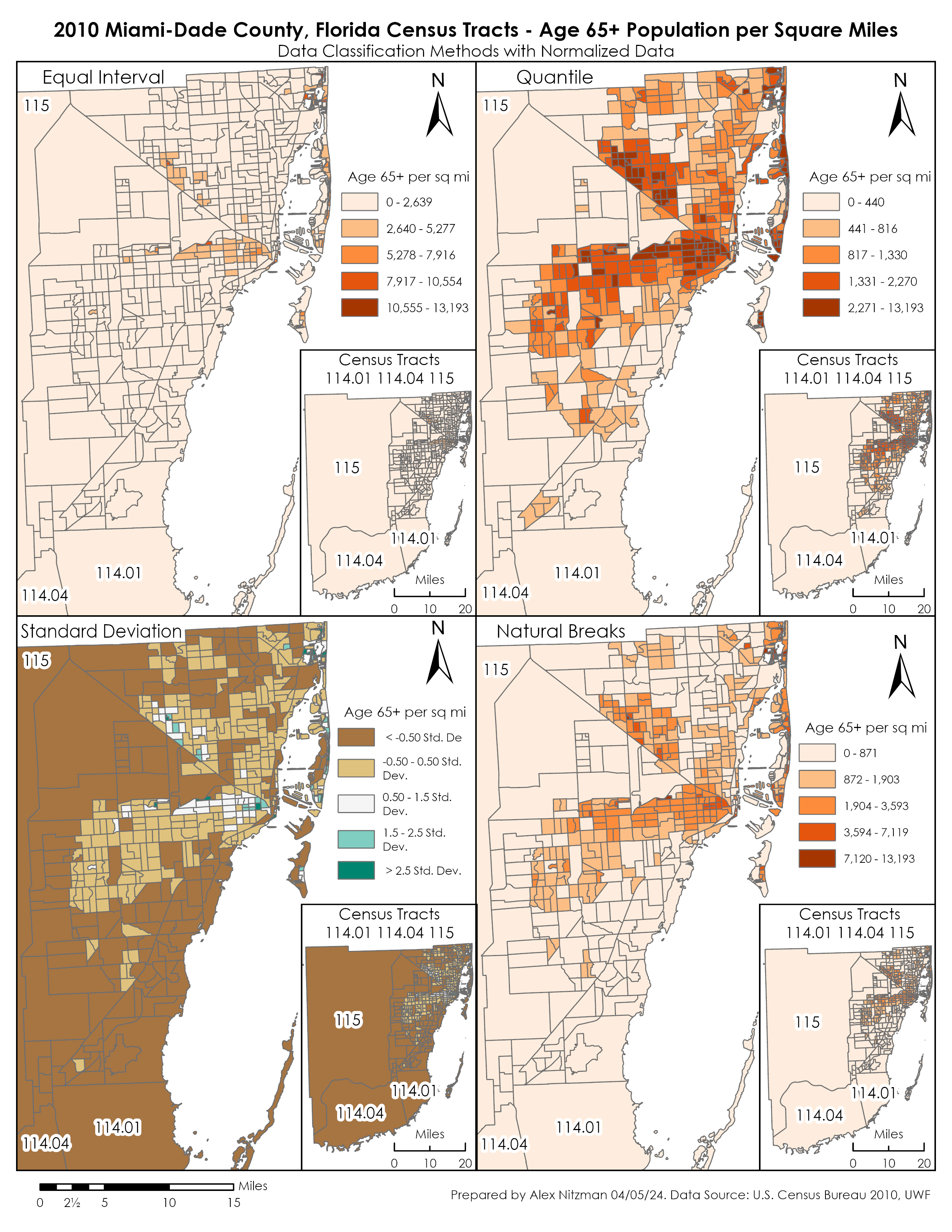
Day 5 – Cincinnati to the Gulf Coast

A few highlights from the final day of traveling from the Cincinnati area back south toward the Gulf Coast of Florida…

The start of the morning has us heading north from the Covington area back into Cincinnati over the Brent Spence Bridge. Opened to traffic in 1963, this double-deck cantilever bridge carries Interstate 71 and Interstate 75 traffic from Kentucky into the western downtown area of Cincinnati, where the two interstates depart for Columbus (Interstate 71) and Dayton (Interstate 75), respectively. A study is currently underway to improve traffic flow and to replace the existing Brent Spence bridge. More than likely, a new structure will be built to replace the almost 47 year old bridge spanning the Ohio River.

Heading north on the lower deck of the Brent Spence Bridge toward the downtown area of Cincinnati. Photo taken 11/08/09.

Part of the trek around the Cincinnati area involved traveling Interstate 471. The short 5.75 mile expressway connects Interstate 71 in downtown Cincinnati with Interstate 275 and U.S. Highway 27 in Kentucky east of Covington and Newport. Originally planned in the 1960’s to connect Covington and Newport as the Riverside Expressway, Interstate 471 saw several changes in its controversial routing before being built in its current location. An interesting note about the expressway, the portion south of the Interstate 275 interchange is actually signed as Interstate 471, and not as Kentucky 471, its hidden route designation south of the greater Cincinnati beltway. So, the question must be asked, exactly where does Interstate 471 end? Most would say at the interchange with Interstate 275 but signs show otherwise…

This guide sign warns motorists that Interstate 471 ends 1/2 mile ahead. This sign is actually found just south of the interchange with Interstate 275 before the at-grade intersection with U.S. Highway 27. Photo taken 11/08/09.

Approaching the intersection with Alexandria Pike (U.S. Highway 27) and the beginning of northbound Interstate 471. Photo taken 11/08/09.

First northbound reassurance shield for Interstate 471 just north of the Alexandria Pike intersection and south of the interchange with Interstate 275. Photo taken 11/08/09.

The Smart Fix project along Interstate 40 between exits 388A (James White Parkway) and 389 (Hall of Fame Drive)in Knoxville, Tennessee is now complete and opened to traffic, as of June 12, 2009, 18 days ahead of schedule. The 14-month closure resulted in mainline Interstate 40 through traffic being rerouted onto Interstate 640 to avoid the construction area. The project included the widening of Interstate 40 into a six-lane urban arterial with four auxiliary lanes, rehabilitation and reconstruction of 13 bridges and other improvements, and a complete renovation of the interchange with Tennessee 158 (James White Parkway) at Exit 388A.

Traveling east along Interstate 40 after Exit 388A in Knoxville. This stretch of interstate was closed for 14 months as part of the Smart Fix project, a project at making a 40 year plus old section of Interstate 40 safer to traffic. Photo taken 11/08/09.

Newly reconstructed overpass for Hall of Fame Drive over Interstate 40 at Exit 389. This aesthetically pleasing overpass was reconstructed as part of the Smart Fix project along the interstate between exits 388A and 389. Photo taken 11/08/09.

Day 4 – Detroit to Cincinnati

Met up with fellow road enthusiast Dan Garnell the night before and discussed various topics around Michigan and the Great Lakes. One such item was the tanker fire that destroyed the 9 Mile Road overpass along Interstate 75. Dan told us that the damaged bridge was removed but little progress was made since the demolition on its replacement. The topic is discussed on the AARoads Forum.

The original Nine Mile Road bridge was rebuilt in 2008. Visible work on Interstate 75 at the overpass involves building new bridge supports.

A number of older state-named signs are still placed along the various freeway frontage roads in Detroit. The dated signs are not as prevalent as you would think, especially considering the derelict nature of the many surrounding neighborhoods in the city.

U.S. 12 represents the long survivor of five U.S. highways that once traveled through downtown Detroit. The highway follows Michigan Avenue eastward from Dearborn to its current end at Cass Avenue within the central business district. Our investigation of the end however revealed remnant signage beyond the Cass Avenue intersection through to Griswold Street, three blocks to the east. No end sign is posted.

A final eastbound U.S. 12 reassurance marker resides along Michigan Avenue between Washington Boulevard and Shelby Streets. An additional shield assembly was posted one block further east, but it was missing its U.S. 12 marker. Both assemblies and a companion westbound placard are posted east of the 2005 truncated end at Cass Avenue.

Michigan 85 ends assembly posted at the intersection of Fort and Griswold Streets in downtown Detroit. M-85 constitutes a 22.15-mile route between Interstate 75 Exit 28 and central Detroit. M-85 overtook a portion of M-3 along Fort Street between Clark and Griswold Streets in 2001 when the city of Detroit assumed control of the former state routes in the Campus Martius area.

(more…)

More from my New Mexico trip of November 2008, including some actual New Mexico this time.

Colorado state route 17
On the mountain pass between Chama, New Mexico, and Cumbres, Colorado – both states call this one highway 17. The sky was dark blue, just after sunrise – the snow is that bright, and there is just that little atmosphere, at 10,000 feet.

New Mexico U. S. highway 64, New Mexico state route 325
Sunset over the plains of northeast New Mexico. Old US-64 (now state highway 325) near Capulin Volcano.


An undisclosed location in northeast New Mexico, home to my friend Dale. Certainly no old signs to be found anywhere.

(more…)

Time for some photos from my trip from San Diego to eastern New Mexico and back, in November 2008. This batch is from the first day of my trip, and is heavily centered around Utah. Specifically: highway 95 in southeast Utah, crossing the Colorado River in red rock country.

Nevada U. S. highway 91, Nevada U. S. highway 466
The only button copy sign in Nevada. This one is very, very old.

Utah U. S. highway 91
Ominous clouds over old US-91 in southern Utah.

Utah state route 24
Red rock country. Utah, everybody.

Utah state route 95
Highway 95 at sunset.

Utah state route 95
Highway 95 somewhat past sunset. This wide-angle shot (about 140 degrees field of view!) is made possible by a fisheye lens and a rectilinear conversion tool. Large version of image is 7000 pixels wide!

(more…)

Day 3 – Petoskey to Sault Ste. Marie to Detroit

Started the day on a frosty morning in Petoskey, traveling up U.S. 31 through resort towns by scenic lakes and hills to its end at Interstate 75. Stopped by Fort Michilimackinac State Historic Park in Mackinaw City to view the Mackinaw Bridge in 27 degree wind. The Mackinac Bridge, nicknamed the "Mighty Mac" or "Big Mac", spans the Straits of Mackinac between Mackinaw City and St. Ignace. The Straits connects Lakes Michigan and Huron and separate the Upper and Lower Peninsulas of the state. Traveling a distance of 8,614 feet, the suspension bridge is the third longest in the world. Drivers travel the span for a total of five miles when incorporating its approaches.

The Mackinac Bridge opened on November 1, 1957 after three and a half years of construction to replace ferry services connecting U.S. 23 with U.S. 2 at St. Ignace. Towers of the signature span rise to a height of 554 feet and are sunk 210 feet into the submerged bedrock. Every Labor Day morning two lanes of the span are closed to vehicle traffic for the annual Bridge Walk.

Tolls are levied to cross the bridge in both directions at a rate of $3.00 per passenger vehicle. Speed limits are set at 45 for passenger cars and 20 mph for commercial trucks. There are no shoulders on the bridge and the inside lanes constitute an open steel grid to reduce both its load and improve its wind resistance.

Interstate 75 draws to a close at the customs station just north of the Exit 394 diamond interchange with Easterday Avenue in Sault Ste. Marie. The customs plaza lies at the foot of the tolled International Bridge leading north to Sault Ste. Marie, Ontario. Fees to cross the cantilever bridge are set at $2.50 per passenger vehicle.

(more…)

Day 2 – Seymour, Indiana to Petoskey, Michigan

Heading north from southern Indiana to the capital city, Interstate 65 continues with four lanes and loads of tractor trailers. The constant beating the pavement takes from the moving freight prompted officials to resurface the route from Whiteland to Greenwood in 2007 as part of the INDOT Major Moves initiative. Expansion of the road to six lanes does not occur until Exit 99.

Interstate 65’s diamond interchange with Indiana 46 was upgraded to a single point urban interchange. In addition to the ramp reconfiguration, decorative arches were added to the Interstate 65 bridges over the state road.

Once in the downtown Indianapolis area, Interstate 65 briefly joins with Interstate 70 on the east side of the central business district. This stretch was rehabilitated in 2003 as part of the “Hyperfix 65/70″ project by INDOT. 33 bridge decks and 35 lane miles of concrete were repaired to go along with capacity improvements as part of a $30-million project. This stretch opened in 1976.

Morning traffic slows toward the Exit 113 split-diamond interchange, the main access point into downtown Indianapolis from Interstate 65 north. Pictured here are stacked ramps built at the split with Interstate 70 over a ghost ramp that was intended to join the freeways with unconstructed Interstate 69.

Encircling the city is Interstate 465, Indianapolis’ beltway and a myriad of vastly unsigned overlaps. They include U.S. 31, 36, 40, 52, 421, and Indiana 37 & 67. Construction is underway on two projects involving the 53-mile loop. The first is emergency work to repair a bridge at the Interstate 69 interchange that was damaged when a propane truck exploded in late October. The freeway was briefly closed in both directions so crews could assess the damage and make emergency repairs. Work currently shifts the westbound direction above the I-69 southbound on-ramp as crews finish repairs.

Additional work along Interstate 465 was completed in 2008 involving pavement rehabilitation from Fall Creek to Interstate 74, joining other recently completed work focused on widening of Interstate 465 between the split with Interstate 74 west and 56th Street. The $74.8-million work included the upgrading of the 38th Street interchange. Construction on this stretch, one of the oldest of the beltway, was completed between 2007 and 2009.

Accelerate 465 entails Interstate 465 southward from Interstate 74 to Interstate 70 on the southwest side of Indianapolis. Upgrading of the freeway will result in 12 foot travel lanes, a 30 foot paved median with jersey barrier within a minimum 216 foot right of way. Interchange improvements are included. At Interstate 74 / Crawfordville Road (U.S. 136), new ramps will join U.S. 136 with both freeways (currently not a direct movement). High speed flyover ramps will be added to the interchange with Interstates 74 and 465 and eliminate some of the loop ramps and associated weaving traffic movements. Work also will upgrade interchanges with West 10th Street, U.S. 36 (Rockville Road), U.S. 40 (Washington Street), the Sam Jones Expressway, and Interstate 70. The Interstate 70 work will replace the eastbound to northbound loop ramp with a 40-mph design speed flyover.

(more…)

I’ve decided to go with this batch of wintry goodness: a November, 2008 trip to Minnesota, Wisconsin, and Michigan.

Michigan U. S. route 45
It was a dark and snowy night…

Michigan U. S. route 45
Don’t eat the orange snow. Distant municipal lights provide the mushroom-cloud effect. I took this picture by the side of US-45 in Michigan.

Michigan U. S. route 41, Michigan state route 26
The US-41 bridge in Houghton, Michigan.

Michigan U. S. route 41, Michigan state route 203
Oh, nothing to see here, just the last embossed cutout US shield in the wild. Both that and the M-203 date back to the 1930s, and have definitely been repainted several times.

Wisconsin U. S. route 14
The oldest shield in Wisconsin, complete with old-style CITY banner. This one, and one just like it further down the same road, date back to about 1958.

Wisconsin U. S. route 51
Sunrise on the third day, along US-51 in Wisconsin.

(more…)

Some notes from a recent five-day road trip from the Gulf Coast northward to Sault Ste. Marie, Michigan.

Widening is currently underway along Interstate 65 in Montgomery, Alabama. This project totals 4.613 miles in length and focuses on replacing the original concrete surface with asphalt while expanding the previous four-lane freeway into six lanes overall. Work exists between U.S. 80 (Exit 167) and the Alabama River bridge. Overhead highway signs along the stretch were replaced during the project. See Progress65 for more details.

New diagrammatical overhead for the split of Interstate 85 north from Interstate 65 north in Montgomery.

Continuing north along Interstate 65, widening is also underway between Exits 262A and 264 in north Birmingham, with additional work slated for next year from Exit 265 to 267. Construction focuses on the building of new collector/distributor roadways that will eventually serve the eastern terminus of Interstate 22 (Corridor X). No work has commenced on the interchange itself, but some land clearing of for the eventual path of the new highway has already occurred.

A look at the ongoing road work along Interstate 65 through northern reaches of Birmingham.

(more…)

sale, sale, sale!

I’ve got this Arizona US 89 on eBay right now.

and am putting in an order for shields in general. Email me at shields@aaroads.com with your request – any state, any number.

it’s my blog and I’ll post random photos if I want to!

two from sunset, tonight here in northeastern New Mexico.

November sunset in New Mexico

November sunset in New Mexico

some sign-oriented photos soon … going to be making a small trip this weekend with fellow AARoads contributor Kevin Trinkle; hopefully some good New Mexico, Colorado, Oklahoma, and Texas photos will result from that.

Next Page »