| U.S. 82 East |
|
This view looks eastbound along US82 / SH 114 just east of the US 62 split at Ralls, in Crosby County. While overlaping with US 62 through Lubbock, SH 114 continues eastward with US 82 instead. Photo taken 01/27/08. |
|
US 82's first eastbound state highway past its overlap with US 62 is at SH 207, here in the town of Ralls. Photo taken 01/27/08. |
|
The US highway runs just south of downtown Ralls. The town was founded in 1911, and is a local market for the cotton industry. Otherwise, there is not much to the place. Photo taken 01/27/08. |
|
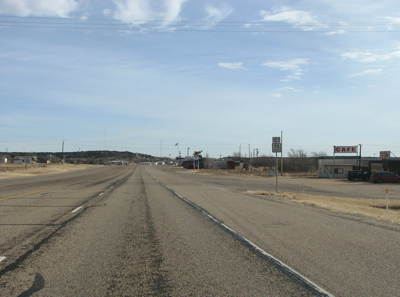
US 82 eastbound at SH 207. SH 207 runs southward to Post and US 84. Northward, it runs all the way into the Texas Panhandle to IH 40 and beyond. US 62 used to branch of here, until the Ralls bypass was built to the west. This sign is a mistake, and should say "To" US 62. Photo taken 01/27/08. |
|
US 82 / SH 114 eastbound reassurance marker at Ralls, just east of SH 207. Photo taken 01/27/08. |
|
East of Ralls, the speed limit jumps up to 70 mph. East of Lubbock to this point, the divided highway has carried a 65 mph speed limit. Photo taken 01/27/08. |
|
US 82 runs through the cotton country of Crosby County. This land is known as the Caprock, and is generally very flat with natural depression lakes called "playa lakes" (pronounced Plae-yuh). The land of the eastern Caprock is used for cotton farming and agriculture, due to a good irrigation supply in an underground aquifer and lots of sunny days. Photo taken 01/27/08. |
|
The next eastbound town is the county seat of Crosby County, Crosbyton. The main north/south road through town is FM 651, which runs southward to Post and north through Blanco Canyon to near Floydada. Blanco Canyon is known as the place where Spanish explorer Coronado camped in 1540 as he looked for the city of gold. Photo taken 01/27/08. |
|
US 82 eastbound at FM 651 in Crosbyton. Crosbyton's population of about 1800 is mostly occupied with cattle and cotton. For a time, it was known as a renewable energy center as the world's largest solar power apparatus was a few miles south of town. Photo taken 01/27/08. |
|
US 82 eastbound reassurance marker east of FM 651 in Crosbyton. Photo taken 01/27/08. |
|
Leaving Crosbyton, US 82 continues along the Caprock. Cotton frames the shoulders of this highway, and most of the others in this region of Texas. It's too light to stay in the trucks that haul it, and at harvest time the land can be covered with little white puffs of cotton. Photo taken 01/27/08. |
|
After Crosbyton, there is not much in the way of human habitation until Dickens, some 22 miles ahead - and even Dickens is not much more than a speck. Photo taken 01/27/08. |
|
The last tree of the Caprock is visible as US 82 takes its first plunge off the Caprock, east of Crosbyton. Photo taken 01/27/08. |
|
As the Caprock, which is topped with a hard clay layer gives way - the highway dives into the valley of the White River. White Falls sits in this valley, which features undulating terrain and many, many, deer. Pronghorn Antelope can also sometimes be seen in these valleys, as they were reintroduced in the last century. Photo taken 01/27/08. |
|
Before reaching the White River, US 82 meets FM 2591. Photo taken 01/27/08. |
|
The sad reality of the plains, and one of many reasons they are not very populated, is the constant danger of tornadoes. Here in the White River Valley, US 82 hosts one of Texas' fine rest areas - complete with wifi and a tornado shelter. Photo taken 01/27/08. |
|
FM 2591 runs northward up the valley into cattle ranching country. Photo taken 01/27/08. |
|
A view of the river valley, with the rest area visible in the center of the photo. Another finger of the Caprock is visible on the horizon. Photo taken 01/27/08. |
|
This view looks eastbound along US 82 / SH 114 in eastern Crosby County. Photo taken 01/27/08. |
|
The highway hops back up onto the Caprock again, and the first Clearview sign points the way to Doughtery, some 22 miles north. Photo taken 01/27/08. |
|
FM 28 connects US 82 with the grain-elevator town of Doughtery in Floyd County, and eventually US 62. This is the Caprock again, so cotton fields once again become the prevalent scenery. Photo taken 01/27/08. |
|
US 82 eastbound reassurance marker along the Caprock past FM 28. Photo taken 01/27/08. |
|
Spur is the next control point along the highway eastbound, Spur sits in a valley about 18 miles to the south. Photo taken 01/27/08. |
|
FM 836 is the next FM road encountered along US 82 eastbound. The road only runs north for a few feet before turning into a county road - the author is stumped as to the reason. There may have been a town there at some point, which is today missing. Photo taken 01/27/08. |
|
Another reassurance marker east of FM 836, amongst the cotton fields. Photo taken 01/27/08. |
|
East of FM 836, US 82 meets the very sparsely populated Dickens County. Not named for the British author, but instead an Alamo casualty - Dickens County is one of Texas' rather monotonous cadre of square counties which populate the northern part of the state. Photo taken 01/27/08. |
|
Dickens is listed as 11 miles distant, as US 82 prepares to depart the Caprock for good. Photo taken 01/27/08. |
|
|
|
These views show the road as it leaves behind the Caprock for the more interesting (to this writer, anyway) red Permian Plains (also called the central plains). There is very little traffic here, and refreshing views in all directions of undulating mesquite tree brush countryside. To the right, the motorist can view Haystack Mountain. Photo taken 01/27/08. |
|
A rare reassurance shield pops up here in Dickens County, which has no cross roads save for a few tracks into farms or oil fields. Photo taken 01/27/08. |
|
Dickens appears on the horizon a few minutes later, the town is the county seat and sits on the side of a hill. Photo taken 01/27/08. |
|
SH 70 is the main north/south road in Dickens County, and is the first important crossroads encountered east of Crosbyton. Photo taken 01/27/08. |
|
Curiously, there is no northbound SH 70 marker, only this southbound one. The 315-mile road runs south to IH 20 and eventually to US 277. The intersection is marked only with a flashing yellow light, and the US 82 motorists are not required to stop. SH 70 runs north to IH 40 and Perryton. Photo taken 01/27/08. |
|
Loop 120 is the only Loop in Dickens County, and runs in a loop from SH 70 through central Dickens. The author notes he has rarely seen such a worthless state highway designation in this state. Dickens has, at most, 200 people and only a smattering of businesses. Photo taken 01/27/08. |
|
US 82 eastbound at Loop 120 in Dickens. To the left, the motorist can view a large hill and on the right great views of the central red plains are visible, spreading out for many miles. Photo taken 01/27/08. |
|
US 82 eastbound reassurance marker in sleepy Dickens, TX. Photo taken 01/27/08. |
|
The divided highway returns on the east side of town, as the land once again opens up. Photo taken 01/27/08. |
|
A bit of the view to be had to the south is now visible to the east, as US 82 takes another downward plunge. The terrain in this part of Texas consists of a number of "steps" of escarpment, broken up by hilly ridges and small river valleys. The steps, once continental shelves of an ancient sea, eventually fall to the Gulf of Mexico's coastal plain. Photo taken 01/27/08. |
|
|
|
These are views of the Croton Breaks, east of Dickens. The land here is red with large outcroppings of rock on each side of the road. The highway falls again to more plains, but the vegetation here is a bit more "lush" than anywhere seen thus far along the road. Photo taken 01/27/08. |
|
US 82 eastbound reassurance marker in eastern Dickens County. Photo taken 01/27/08. |
|
FM 2941 is one of the only FM roads in the eastern part of the county, and runs northward to cattle ranches and oil fields. Photo taken 01/27/08. |
|
|
Two entirely car-free views in eastern Dickens County. US 82 has very low traffic counts through here, and the author wonders why it is a 4 lane divided highway (although he is certainly not complaining about it). Photo taken 01/27/08. |
|
Upon entering King County, US 82 is reduced to two lanes. The few signs of life appear in signs warning of possible cattle crossings. Photo taken 01/27/08. |
|
US 82 reassurance marker in King County. The county, another square, was named for William King - an Alamo casualty. Photo taken 01/27/08. |
|
King County's only town, and thus the county seat, is Guthrie. The town is unincorporated and has only one gas station for its business. Photo taken 01/27/08. |
|
The first road that is encountered in King County is US 83, here at Guthrie. Photo taken 01/27/08. |
|
US 83 is a major north/south road in Texas and is generally used for dividing the state into east and west halves. The US highway is a whopping 783 miles long in Texas alone, and runs from Oklahoma all the way to the Mexican border. Photo taken 01/27/08. |
|
US 82 meets US 83 in Guthrie. While the census states that the population of Guthrie is 160, there are little signs of life to be had there. Photo taken 01/27/08. |
|
US 82/83 southbound through Guthrie. The small county courthouse and several abandoned business sit in the center of town. Photo taken 01/27/08. |
|
Somewhat comically, a bypass is being built around Guthrie. When completed in late 2008, it will carry traffic on US 82 around town to the west and south. Ranch brands are shown on the overpass retaining walls. US 82 traffic must turn left here to continue going eastward. Motorists going straight on US 83 will eventually reach the Rio Grande Valley. Photo taken 01/27/08. |
Page Updated February 1, 2008.