Baja California - Mexico
Photos covering Mexico 1-D, Mexico 1-D in and around Tijuana from a roadtrip in May 2001. Thanks to Don Hagstrom and Kevin Trinkle for making this trip possible.
Mexico 1 and Mexico 1-D
Most of the land north of the International boundary where Mexico 1 crosses from Tijuana to San Ysidro is undeveloped. This is because much of the land in the United States adjacent to the border is part of Border Field State Park. The state park encompasses the Tijuana River Valley, which is mostly wetlands and foothills as well as coastal estuary. The city of Tijuana, meanwhile, sprawls all the way to the border fence, offering a major contrast between the United States and Mexico at this point along the border. At this point, Mexico 1-D is no longer a toll road, and it rapidly transfers onto Tijuana city streets. The connection from there to the border crossing and Interstate 5 is a bit convoluted, as one must navigate city streets to reach the border. There was a proposal to construct a new border crossing at approximately this location into the United States, but the environmental sensitivity of the Tijuana River Valley and Border Field State Park prevented such a route from being constructed.
Kilometers along Mexico 1-D increase from Tijuana southward. The Zero kilometer post is the near the interchange with Mexico 2. Generally, there are not many reassurance shields, so the kilometer posts acts as reassurance markers.
Rosarito Beach is popular for its playas (beaches) and resorts. A popular weekend destination for Americans, it is also home to a vibrant night club scene. The community is also home to the large Presidente Juarez complex, a natural gas power plant located adjacent to the ocean. This power plant was upgraded from oil burning to natural gas. There are three separate units in the Presidente Juarez complex: Rosarito I built in 1963, Rosarito II built in 1991, and Rosarito III built in 2001. It produces 1,328 megawatts, which is enough to bring power to about 1.4 million homes. Some of this electricity is exported to the United States. Capacity for trans-border power transmission is 408 megawatts, but was forecast to increase to 2,400 megawatts by 2003. Power lines spanning Mexico 1D were constructed in the late 1990s. They made the news on September 27, 2001, because a short circuit along the line caused an extensive power outage in a swath across Baja California, including all of Rosarito Beach and most of Tijuana and Tecate. (Most of this information is courtesy of research in the San Diego Union-Tribune.)
Mexico 2 and Mexico 2-D
The only reassurance markers for Mexico 2 between San Luis Colorado and Mexicali appear on kilometer posts, and on the overhead signage at intersections. Kilometers increase from east to west.

Most speed limits in Mexico are posted within a red circle on a square sign. The appropriate speed limit is shown within the red circle, similar to this sign on eastbound Mexico 2-D. May 2000

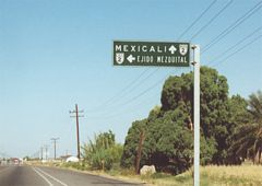
A large "Bienvenidos a Mexicali" sign welcomes motorists along westbound Mexico 2 entering the city of Mexicali. Mexico 2 partitioned into bypass and bypass routes. May 2000

The Zero kilometer post for Mexico 5 stands near the intersection with Mexico 2. Signage for Mexico 5 was found near the border crossing. May 2000

Located prior to the beginning of the Mexico 2-D toll road, this sign directs motorists to a Pemex plant south of Mexico 2. Pemex is the national gasoline manufacturer in Mexico; it is the only source for gasoline in the country, since it is nationalized (owned by the Mexican government). May 2000

Monument signifying the beginning of the toll road as Mexico 2 transitions to Mexico 2-D west. May 2000

Monument signifying the beginning of the toll road as Mexico 2 transitions to Mexico 2-D west. May 2000

This jurisdictional sign along Mexico 2-D west indicates the end of the "county" (municipality) of Mexicali and the beginning of the "county" (municipality) of Tecate. "Termina" means "end," and "Principia" means "begin." May 2000

The Mexico 2-D toll road traverse an area of stark desert valley on the approach to La Rumorosa Grade. May 2000

The Mexico 2-D toll road traverse an area of stark desert valley on the approach to La Rumorosa Grade. May 2000

Power lines along the south side of Mexico 2-D roughly parallel the toll road from Mexicali to near Tijuana via Tecate. May 2000

Signs along westbound Mexico 2-D remind motorists that slow traffic ("transito lento") should remain in the right lane. Other signs indicate that passing traffic should use the left lane. May 2000
Photos by AARoads
Page Updated Saturday February 01, 2025.


