
Spent Saturday redriving many of freeways of metro Boston, Rhode Island, and eastern Massachusetts.
Started things off by heading northward into the Big Dig and then northeast across the Tobin Bridge to the U.S. 1 Northeast Expressway. A repainting job is underway along the Tobin Bridge at mid-span. U.S. 1 was once touted as part of the through-city routing of Interstate 95 through Boston. A section of the highway is a full fledged freeway between Interstate 93 and Lynn Street at the Suffolk/Middlesex County line. From there northward, U.S. 1 exists as an expressway devoid of cross-traffic or intersections, but lined on either side with an array of businesses and shopping plazas. This unsual configuration lasts the entire northward drive from Boston to junction Interstate 95/Massachusetts 128 and Peabody. Intersections along the routing are replaced with interchanges. Right-hand turns are permitted but there are no traffic lights. A jersey or guard rail median separates the north-south movements and prohibits left-hand turns.
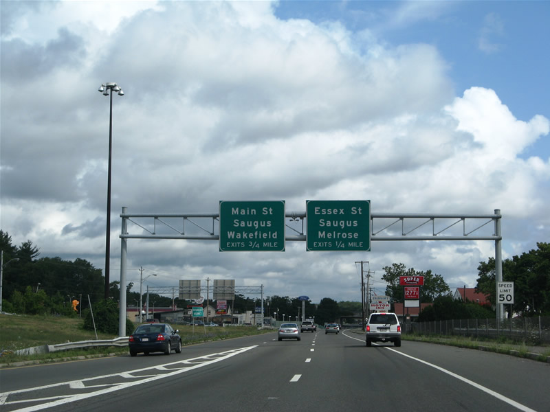
U.S. 1 transitions into an expressway (Frank P. Bennett Memorial Highway) at Malden, north of the Lynn Street. Interchanges exist along the northward drive to Peabody including those at Essex Street, Main Street, and Lynns Fells Parkway at Saugus.
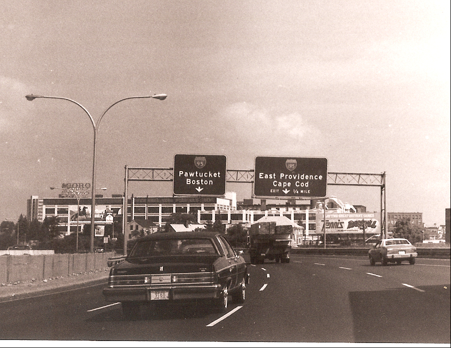
We doubled back southward along Interstate 95 & Massachusetts 128 around the city of Boston. A busy six-lane freeway, Massachusetts 128 predates the Interstate system in construction and was grand fathered in as Interstate 95 when it was determined that I-95 would not be built through the city. Signs refer to both highways as Interstate 95 and Massachusetts 128 throughout their shared alignment. Massachusetts 128 east of Interstate 93’s southern terminus however was eliminated in 1997.

U.S. 1 joins Interstate 95 in a wrong-way overlap between Exit 15 and junction Interstate 93. This cosigning creates a situation where Interstate 95 south & U.S. 1 north sharing the same carriageway. A similar configuration occurs with U.S. 3 and Interstate 95’s brief overlap between Exits 32 and 33. U.S. 1 follows Interstate 95 south and Interstate 93 north between Dedham and the Tobin Bridge.
Construction is present at the Interstate 95, Interstate 93, and U.S. 1 junction at Canton, Massachusetts.Work began April of 2004 and should be completed in Fall of 2007. The project http://www.mhd.state.ma.us/ProjectInfo/Main.asp?ACTION=ViewProject&PROJECT_NO=602288 includes the addition of one general purpose lane per direction within the median of both Interstates 93 and 95 leading east and west of the interchange. Widening also includes the building of full left-hand shoulders and auxiliary lanes.
Additionally the Interstate 95 southbound ramp leading away from Massachusetts 128 will be widened to two lanes. Interstate 95 & Massachusetts 128 bridges over the Neponset River, Amtrak, and University Avenue were already replaced during this project.
Shifting northward through Quincy and Boston, Interstate 93-U.S. 1 join with Massachusetts 3 between downtown Boston and Exit 7. The eight-lane freeway between the Massachusetts 3 (Exit 7) interchange and the Big Dig includes a time-variable HOV-2 lane. Depending on whether it is the in-bound morning peak hours or out-bound evening peak hours, a zipper jersey barrier is moved to convert the left-hand lane of Interstate 93-U.S.1-Massachusetts 3 into a carpool lane. The barriers prevent lane changing and reduce the number of general purpose lanes from four to three of the direction affected.

Interstate 93, U.S. 1, and Massachusetts 3 pass through a cut and cover tunnel below Boulevard Street in Milton. The freeway sinks below grade between Exits 9 and 11. No shoulder or break down lanes exist here.
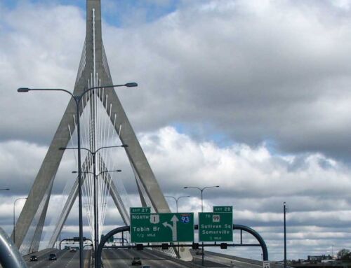
We looped east along Interstate 90 through the Ted Williams Tunnel and northeast via Massachusetts 1A to Massachusetts 16 west to U.S. 1 (Tobin Bridge) south and Interstate 93 south.

We looped east along Interstate 90 through the Ted Williams Tunnel and northeast via Massachusetts 1A to Massachusetts 16 west to U.S. 1 (Tobin Bridge) south and Interstate 93 south. This view is afforded to southbound drivers as they cross the Charles River across the cable-stayed Zakim Bridge. The green swath of land in the background represents the former location of the Fitzgerald Expressway viaduct. Much of the demolition and conversion of the land into a green space park is complete.
Next on our drive was a trip down Massachusetts 3 toward Plymouth, an amazingly busy four-lane freeway joining metro Boston with the Cape Cod region via the Sagamore Bridge. This road and Interstates 495 and 195 become increasingly busy during the Summer months with traffic headed to the coast for weekend trips. Portable VMS recommended avoiding travel on all three routes toward the Cape between 2 and 7 pm on Sunday.
A new freeway exists in southeastern Massachusetts that carries U.S. 44 west from Plymouth to junction Massachusetts 58 at Carver. With the new highway, U.S. 44 now shares a mile with the Massachusetts 3 freeway between Exits 6 (Samoset Street) and 7 (the new freeway). We traveled west on the entire length of the sleek four-lane highway to its end at the Massachusetts 58 diamond interchange. West of there, the highway transitions into median separated super-two expressway to a signalized at-grade intersection with junction Massachusetts 105.
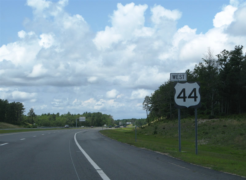
U.S. 44 “tip-hat” shield posted west of the interchange with Commerce Way on the 2005-opened freeway. With increased coastal growth expected at Plymouth and the high speeds along U.S. 44, upgrading the highway into a full freeway all the way west to Interstate 495 is a good idea, though we are not aware of any plans.
A three mile long back-up resulted from beach-bound traffic along the Bourne Bridge and freeway leading north from Massachusetts 28 at Buzzards Bay to the U.S. 6 interchange at Bourne. That is as far southeast as we pushed along the six-lane Massachusetts 25 freeway between Interstates 195 & 495 and Massachusetts 28. We opted to head west to Rhode Island instead.
Resurfacing was underway along Interstate 195 through the city of Fall River. This project follows redecking of the Charles Braga Bridge across the Taunton River in 2005. Massachusetts 24 ties into Interstate 195 here between its freeway legs southward to Rhode Island and northward to Taunton. Massachusetts 24 took us south to Rhode Island 24 and its end at junction Rhode Island 114 at Portsmouth.
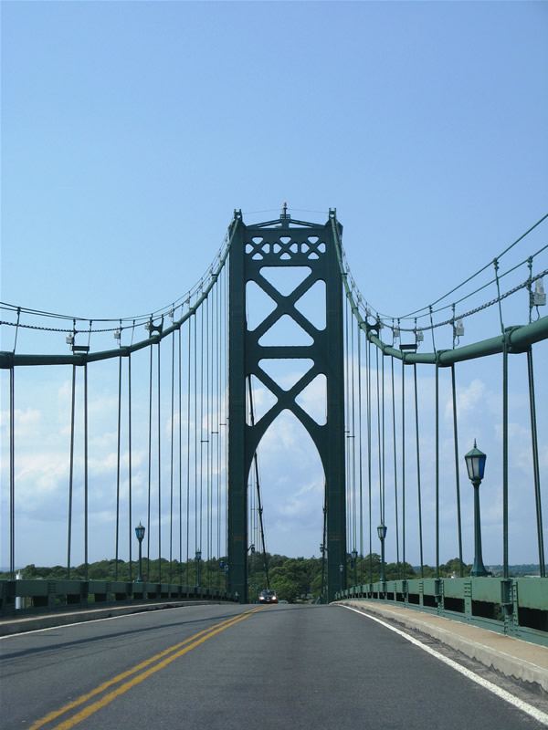
Rhode Island 114 spans Mt. Hope Bay between Portsmouth and Bristol via the two-lane Mt. Hope suspension Bridge. This bridge was built between 1927 and 1929 and includes ornate lighting fixtures. Cable lights accent the bridge at night.
Further west within the capital city of Providence, work continues on the new Interstate 195 alignment and Providence River Bridge. Significant progress was made since our 2005 trip through Rhode Island. Arches of the new signature span for Interstate 195 are now visible and flyovers are partially constructed at the future Interstate 95 and 195 junction south of downtown. Upon completion, a high-speed interchange will join the two highways near the confluence of the Providence and Seekonk Rivers, over one half mile south of the present Interstate 195 western terminal.
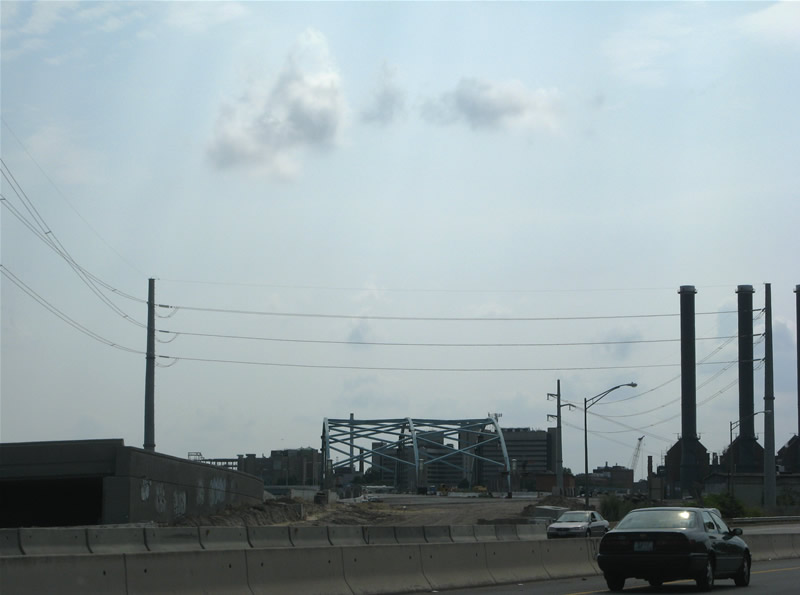
Looking southwest from Interstate 195 at the new Providence River Bridge from near the Washington Bridge over the Seekonk River. New Interstate 195 will veer southwest over India Point Park to Interstate 95. The original right-of-way will be converted into new parkland upon completion of the project.

New flyovers rise above Interstate 95 southbound that will join with Interstate 195 and parallel Eddy Street.
Interchange work and the new Interstate 195 Providence River Bridge and alignment should be completed by late 2009. Additional work involving upgrading Interstate 95 within the vicinity and removing the old Interstate 195 alignment will continue to mid-2012.
Meanwhile crews are replacing all aged signs along the entire alignment of Interstate 295 to the west and north of Providence. Gone now are the dual exit/mile tabs at some of the Interstate 295 interchanges. So Interstate 295 and Rhode Island will remain a sequential-exit numbering state with no reference to the milepost at any of its exits.

Stacks of decommissioned signs set beside new reflectorized signs awaiting installation on Interstate 295 between Exits 9 and 10.
After a jaunt westward to New London, Connecticut and southward onto the Rhode Island 4 freeway, we returned north. Night fell upon us by the time we returned to Quincy by way of Interstate 95 north, Interstate 495 south, Massachusetts 24 north, and Interstate 93 north. Cutout fans will find a set of U.S. 1 shields at the north end of Massachusetts 24. The cutouts are merely signs normally placed on overheads, not vintage or old-style designs.
