
Tampa Bay, FL
Overview
The Tampa Bay Area metropolitan area includes the cities of Tampa, St. Petersburg, and Clearwater. Tampa is the largest of the three cities, with nearly 350,000 residents and an area of 170 square miles. The city was originally incorporated in 1869. St. Petersburg, a city of 137 square miles, anchors southern Pinellas County with around 250,000 residents. It was incorporated in 1892. Clearwater, the Pinellas County seat, lies between the Gulf of Mexico and Old Tampa Bay along both U.S. 19 and State Road 60. The 39 square mile city is home to over 100,000 and was incorporated first in 1891.

Pinellas County was formed in 1912, when it separated from Hillsborough County. A popular beach destination, magazines routinely rate Pinellas County beaches among the best in the entire country. However, with only 280 square miles and a booming population of 916,542 as of the 2010 Census, Pinellas County is perhaps the most densely populated county in Florida. Even Miami-Dade County, with its dense urban atmosphere near the coast has a significant amount of undeveloped land in the Everglades. No similar amount of undeveloped land is found in Pinellas County, with the exception of the Brooker Creek Preserve north of Oldsmar.
Historical Maps


Unconstructed Pinellas Belt Expressway
There are several freeways that were planned but were canceled and not constructed. One of these was the Pinellas Belt Expressway, which was touted as a beltway that would connect with the Interstate 275 and Interstate 175 interchange at its southeastern end. It was then planned to follow today's U.S. 19 Alternate/SR 595 west to Seminole Boulevard and then aim north, connecting with the unconstructed Ulmerton Road Freeway (SR 688, which is no longer slated to be upgraded to a freeway) and then merging with the canceled St. Petersburg-Clearwater Expressway, a diagonal route from Interstate 275 north of the I-275/375 interchange and angling northwest to Largo near the U.S. 19 Alternate and SR 686 (East Bay Drive) intersection.
The Pinellas Belt Expressway was actually budgeted for construction in 1974, but local opposition prevented the freeway from progressing. This freeway would have taken via eminent domain a good deal of commercial areas, including retail outlets, but several homes would also have to be condemned and removed. This was unacceptable to residents, so the freeway was canceled by the late 1970s. However, certain segments were built, including the full freeway interchange between U.S. 19 Alternate and SR 666 in Bay Pines/Seminole.
Routes
 Interstate 4

I-4 just before opening in 1961. This view looks eastward, Adamo Drive (SR 60) can be seen in the top right. (Photo : Hillsborough County City-County Planning Commission)

The western end of I-4 in 1970. Only 5 years old and already there was a constant backup at the Downtown Interchange. (Tampa Times photo)
Interstate 4 constitutes a major freeway across the Florida peninsula along the U.S. 92 corridor. It begins at the Downtown Interchange with I-275 in Tampa, then proceeds in an easterly direction toward Plant City, Lakeland, and Orlando. I-4 was both the first Interstate in Hillsborough County and statewide in Florida to be completed. Its origins in Tampa date back to 1941 as part of the Grand Central Expressway plan along what is now Kennedy Boulevard (SR 60). Planning maps displayed the current Interstate 4 in 1958, with staged construction following. The first portion completed was the stretch from U.S. 301 (Exit 7) to the Polk County line in 1960. The Downtown Interchange opened in 1964, with completion of the route in Hillsborough by 1965.1
Growth quickly accompanied the newly opened Interstate 4, and cities along it through Hillsborough, Orange and Polk Counties grew by 24% between 1964 and 1970. Traffic congestion ensued, and 100,000 vehicles per day were recorded along I-4 at 22nd Avenue (Exit 1) in 1970. Expansion for I-4 from I-275 east to Lakeland was planned for the period between 1987 and 1992. Construction however was delayed significantly in 1991 when the state reallocated funds for I-4 to expanding I-75 through North Florida instead.1
Within Hillsborough County, Interstate 4 was expanded to six overall lanes through various projects between September 1995 and December 2007. This included total reconstruction of the route in Tampa, with new carriageways built outside a wide grassy median. The median may be used for light rail in the future. Further east through Lakeland, widening was completed through Polk County in 2007.
 Interstate 75
Interstate 75 provides the most direct route from the Tampa Bay region to Southwest Florida and Miami to the south and to Ocala, Interstate 10 near Lake City and points north to Atlanta and Michigan. The freeway stays east of Tampa, acting as a bypass of the metropolitan area while doubling as a commuter route for residents of Pasco County, New Tampa, Brandon, Riverview and Gibsonton.
The 1958 plan for Interstate 75 concluded the route in Tampa at what is now the Downtown Interchange between Interstates 4 and 275. This was the case because in 1961 all Interstate miles were already allocated for the state of Florida. The route of I-75 east of Tampa Bay was proposed as a separate bypass and was later incorporated into a freeway stretching to Naples in Southwest Florida. The toll road was tentatively named the West Coast Turnpike and planned for construction over a 15 year period. It included a western spur, the Palmetto Turnpike, to link it with the Sunshine Skyway. Not much was made public about the Western Turnpike, and by 1969 it was dropped in favor of extending Interstate 75 as additional interstate miles were made available to the state.2
Congress approved the route of Interstate 75 from Tampa to Miami in 1968, and the final design was unveiled in 1971. Extension of the route south to Miami involved renumbering I-4 west from Tampa to St. Petersburg as part of I-75. This took place formally in 1971, with I-75 ending at 38th Avenue North in St. Petersburg. Just two years later, I-75 was rerouted to bypass Tampa Bay, leaving the former route along the Howard Frankland Bridge as new I-275.3 Opposition from environmentalists and growing suburban communities rose as plans for construction of the new I-75 were finalized in 1972. Lawsuits from various environmental groups, and later homeowners, delayed work on the road, leading to a change in road design. This entailed angling I-75 further north in Hillsborough County and reducing the freeway from six to four lanes through the Hillsborough River area. The final route of I-75 was scheduled for completion in Hillsborough County by 1982.3
Construction of I-75 through the early 1980s focused on both ends of Hillsborough County, with work progressing to link the separate sections. I-75 was completed from I-275 at the Pasco County line south to SR 582 (Fowler Avenue) in 1984. Opening of the segment between SR 674 (Causeway Boulevard) and Fowler Avenue in 1985 completed the mainline in Hillsborough. Building of the Crosstown Expressway (SR 618) interchange followed in 1986.3
Widening of Interstate 75 to six or eight overall lanes through north Hillsborough kicked off on October 24, 2011 between SR 582 (Exit 265) and SR 56 (Exit 275). This work ran through spring 2016 and coincided with Pasco County expansion of I-75 between SR 56 and SR 54 (Exit 279) between March 2011 and June 2014. Additional work expanded I-75 northward between SR 54 and SR 52 (Exit 285) between May 2014 and Winter 2018.
 Interstate 175 - South Bay Drive
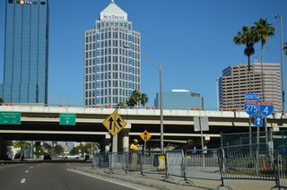
Interstate 175 is a short spur route leading east from I-275 to Tropicana Field (home of the Tampa Bay Rays MLB team) and the south side of Downtown St. Petersburg. One of the shortest Interstate highways in the national system, it runs partially below grade and ends at SR 687 (4th Street S).
I-175 was planned along side I-375 as 'downtown feeders' to St. Petersburg in the mid-1960s as state roads. Construction on both routes followed in the late 1970s, but I-175 was delayed due to the high cost of land acquisition and lawsuits filed in an attempt to halt work. The $5.5 million freeway was the most expensive road per mile to ever be constructed in Florida at the time when it opened on April 23, 1980.5
The 1.44 mile route was incorporated into the Interstate system in 1978 when Florida realized that the state budget would not support completion of its portion of the Interstate system by 1986, when federal funding was scheduled to run out. The state canceled part of I-75 through Hillsborough County to offset the deficit, leaving five federally funded intestate miles to allocate elsewhere. These were used for both I-175 and I-375.
 Interstate 275
Interstate 275 forms a 60 mile long loop west from I-75 through the urban cores of both Tampa and St. Petersburg. A busy route, the freeway winds northward from the Sunshine Skyway through southern Pinellas to the Howard Frankland Bridge across Old Tampa Bay. The freeway turns east toward Downtown Tampa and north along a congested corridor from near Ybor City to North Tampa and Lutz.
Interstate 275 was commissioned in 1973 over the former path of Interstate 75 through both Tampa and St. Petersburg. Construction of I-275 through Tampa initially focused on the stretch between Downtown Tampa and the Howard Franklin Bridge between 1960 and 1964 and from Pasco County southward to Bearss Avenue, which opened in 1961. The east-west portion of the route was designated as Interstate 4 with four overall lanes and an eight foot grassy median.6
Construction of the Downtown Interchange, where I-4 and I-275 currently meet, was completed in 1965. This preceded work to open I-75 southward from Bearss Avenue in 1966. The vigorously opposed stretch of I-75 between Sligh and Floribraska Avenue was completed in December 1967.6
Further south, Interstate 275 spans Old Tampa Bay across the three-mile long Howard Frankland Bridge. The bridge first opened in August 1960 with a single span dumping traffic onto 4th Street North at its west end. Completion of I-75 south into Pinellas aided in the transformation of 4th Street into a busy commercial route. Ensuing commercial interests established along the route delayed construction of I-275 until 1969, when work commenced on an extension south to Roosevelt Boulevard (SR 686) and 58th Avenue North. Subsequent construction extended the freeway south to I-375 in 1978, and I-175 by April of 1980.7
South from Downtown St. Petersburg, construction on I-275 commenced in June 1978. Resistance to the new freeway was less than previously encountered in areas to the north, but opposition from both environmentalists and Eckerd College resulted in some hurdles. Agreed compromises between parties involved were incorporated into the freeway design including landscaping, the installation of sound walls, the rebuilding of a popular marina displaced by the route and the redesign of the Pinellas Bayway/54th Avenue S interchange to reduce to impact to Eckerd College land. Work took I-275 southward to a temporary end point six times from 1978 to 1984. The portion south to 28th Street South opened in January 1981, to 22nd Avenue South in May 1982, and to 54th Avenue South in January 1984.8 The route through to the famed Sunshine Skyway Bridge was opened by June 1985. The cable-stayed bridge was completed in 1987, replacing a cantilever bridge by the same name that partially collapsed in 1980. The four-lane toll bridge totals 4.2 miles over the main shipping channel for both Port Tampa Bay and Port Manatee.
As traffic counts increased, capacity improvement projects were made to Interstate 275 in both Hillsborough and Pinellas Counties. Reconstruction of the freeway took place in Tampa through the 1970s, with expansion to six overall lanes and redesign of the diamond interchange at Memorial Highway (SR 60) into a parclo between 1974-76. The Himes Avenue interchange was first proposed in May 1983 and advertised to enhance access to Tampa Stadium for the 1984 Superbowl. The partial interchange was to be funded by the Tampa Bay Bucs franchise and Westshore mogul Al Austin, who owned a large tract of land near the stadium location. Funding did not accrue in time for the Superbowl, and the interchange was built in late 1984 and paid mostly by the state.6
The Gandy Boulevard interchange with SR 694 was partially completed in 1976. Plans at that time called for Gandy to be built as a full freeway, so elements of the junction with I-275 were tabled until that upgrade came to pass. The cancellation of the Gandy Freeway led to an upgrade at the interchange with I-275 to provide the previously missing movements.7 A second span for the Howard Franklin Bridge across Old Tampa Bay opened in August 1991. The bridge did double duty while crews rehabilitated the 1960 span, ultimately leading to eight overall lanes of capacity.
Modernization of the freeway through both Tampa and St. Petersburg commenced in November 1999 and continues through Fall 2016. This includes the total rebuilding of I-275 between the Howard Frankland Bridge and Downtown Interchange with new carriageways and a wide grassy median reserved for potential light rail. Work included the acquisition of several blocks worth of property to the south of I-275 to accommodate the wider footprint.
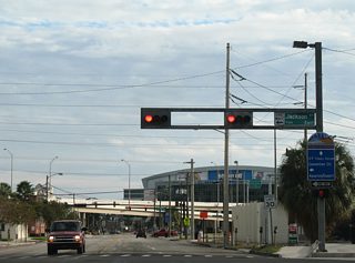
 Interstate 375 - North Bay Drive
Interstate 375 forms a second short spur route leading from Interstate 275 into Downtown St. Petersburg. The 1.34 mile route runs east, partially along a viaduct, to the couplet of 4th and 5th Avenues North (SR 595) near Mirror Lake and just shy of the western terminus of U.S. 92 (4th Street N).
Planned along with I-175 to the south, Interstate 375 cost $3.1 million to build and opened initially from I-275 east to 9th Street North on January 17, 1978. Completion of the route eastward followed in January 1979.5
 Veterans Expressway
Until 1998, the original Veterans Expressway (SR 589) alignment veered east at Van Dyke Road (CR 685A) to end at Dale Mabry Highway (SR 597) near Lutz. SR 589 extended northward in 2001 to Pasco and Hernando Counties along the new Suncoast Parkway. This left the 3.04 mile spur to Dale Mabry Highway as new State Road 568.
Stubs at the east end of SR 568 alluded to former plans to extend the toll road east onto the cancelled Lutz Expressway to Interstate 275. These were removed when the intersection with Dale Mabry Highway was reconfigured to accommodate development along the east side of SR 597. There are no exits otherwise along the route.
 Veterans Expressway / Suncoast Parkway
The Veterans Expressway portion of SR 589 winds northward from Memorial Highway and SR 60 to the Northdale area in northern Hillsborough County. The toll road was completed in September 1994 as a commuter route to alleviate Dale Mabry Highway.
Construction for the northward extension of SR 589 wrapped up in 2001, when the Suncoast Parkway was completed between Northdale and U.S. 98 in Hernando County. The lengthened toll road serves suburban areas of Pasco County while providing a fast route between Tampa Bay and the Nature Coast.
$380 million in road work underway along the Veterans Expressway widened the southernmost 11 miles of SR 589. Included in the work was the elimination of cash collection toll booths and the June 14, 2014 switch to all electronic tolling. Work on the six and eight lane expansion ran through early 2018.
 Lee Roy Selmon Expressway
SR 618 is the tolled LeRoy Selmon Expressway, taking an east-west path across Tampa to Brandon. Mostly an elevated highway, the route is the fastest way from Gandy Boulevard (U.S. 92) and South Tampa northeast to Downtown Tampa. The route east to Brandon comprises an important commuter route to the unincorporated suburb of Brandon. Named the Crosstown Expressway until 2008, it was completed in 1986.
The toll road includes a reversible roadway linking Channelside in Downtown Tampa with Brandon Parkway and Lakewood Drive in Brandon. Designated hidden State Road 618A, the two to three lane roadway flows inbound in the morning and outbound during the evening. It opened to traffic by August 2006.
 Gateway Expressway
The Gateway Expressway is a toll road system with separate branches linking Interstate 275 with U.S. 19 and St. Petersburg-Clearwater International Airport (PIE). SR 686A comprises a four lane viaduct system running along SR 686 (Roosevelt Boulevard) southeast from the Bayside Bridge (CR 611) to SR 690 just west of I-275. Both expressways use all electronic tolling (AET).
The Gateway Expressway project also reconstructed Roosevelt Boulevard from the Bayside Bridge to SR 688 (Ulmerton Road), added a new access road for PIE Airport, and expanded I-275 between SR 694 (Gandy Boulevard) and SR 687 (4th Street N) with express toll lanes. Work ran through late 2021 Spring 2024.
 Gateway Expressway
SR 690 overlays CR 296 (118th Avenue N / Bryan Dairy Road) along a four lane elevated roadway west from I-275 to U.S. 19. Costing $594.7 million, construction on the Gateway Express project commenced in November 2017.
 U.S. 19
U.S. 19 follows the Gulf Coast southward from the Nature Coast through to New Port Richey and built-up areas of west Pasco County. Leading south through Pinellas County, the highway splits with an Alternate route looping west through Palm Harbor, Dunedin, Downtown Clearwater and Seminole while the mainline stays east to Pinellas Park and St. Petersburg. U.S. 19 is heavily congested throughout Pinellas as it provides the main commuter route throughout the urban county. 12.3 miles of the US highway, from Pinellas Park to north Clearwater, run along a limited access freeway.
Leading south from Clearwater, U.S. 19 Alternate expands into an arterial style road though Largo and Seminole to reconvene with U.S. 19 (34th Street North) via 5th Avenue North in St. Petersburg. U.S. 19 follows 34th Street south from Pinellas Park to combine with Interstate 275 ahead of the Sunshine Skyway Bridge while SR 595 provides a direct connection into Downtown St. Petersburg as the former southern extent of U.S. 19.
The overlap between I-275 and U.S. 19 across Tampa Bay is one of three cases in Florida where a U.S. route merges onto an Interstate highway (U.S. 17 on I-10 and I-95 in Jacksonville and U.S. 1 in Miami being the others). The toll bridge turns the paired routes east at Terra Ceia, where U.S. 19 branches southward via a wye interchange for Palmetto. Once in Memphis, north of Palmetto and Bradenton, U.S. 19 ends at its junction with U.S. 41.
U.S. 19 was laid out in 1929 by the federal government through Pinellas County and remained roughly unchanged until the early 1950s. Then a new inland route was constructed, with the former along the coast redesigned as U.S. 19 Alternate. Population growth quickly overran the newer alignment for U.S. 19, resulting in 1962 plans for a parallel freeway along Belcher Road. That route was not funded in time, and a subsequent north-south toll road plan for the U.S. 19 corridor was killed by voters in 1976. All other planned freeways in Pinellas not already under construction at the time were cancelled by the early 1980s.9
Increasing traffic congestion in the mid-1980s led to plan in 1987 to upgrade U.S. 19 to an urban freeway with six overall lanes and a companion frontage road system from Gandy Boulevard (SR 694) north to the Pasco County line. Funding prioritized the building of overpasses and frontage roads at the busiest intersections first, with lower costs upgrades following. Work to add an overpass at Roosevelt Boulevard (SR 686) ran between January 1987 and March 1989. A second set of bridges opened in December 1989 to carry U.S. 19 over Ulmerton Road (SR 688).9
Further construction upgraded U.S. 19 to a freeway on the stretch between Main Street (SR 580) and Countryside Boulevard in Clearwater with work undertaken from 1992 to May 1994. Moving forward, funding issues again arose and pushed U.S. 19 upgrades back into the mid-2000s with completion of work between Pinellas Park and Dunedin. With all but two segments converted to limited access standards by 2009, the two remaining portions: Whitney Road to SR 60 and Sunset Point Road to Countryside Boulevard in Clearwater were completed in summer 2015. Future work to extend the freeway north to County Road 95 near Palm Harbor, including a new interchange with Curlew Road (SR 586), will take place when funding becomes available. Upgrades on the remaining stretch north to Pasco County are not planned at this time.
 U.S. 41 - Tamiami Trail
U.S. 41 is the Tamiami Trail, so named for its connection between Tampa and Miami. In the Tampa Bay area, U.S. 41 stays east of Tampa Bay, paralleling I-75 to the west. Through the city of Tampa, the route partitions with a Business loop through Downtown and the mainline taking a surface bypass partially with U.S. 92 along Hillsborough Avenue. The pair converge ahead of Lutz with U.S. 41 continuing to suburban areas of Land O' Lakes in Pasco County.
U.S. 41 is a suburban commuter route, urban arterial and industrial highway throughout its course through the Tampa Bay area. U.S. 41 Business provides the main route to Port Tampa Bay while U.S. 41 south from Tampa serves the growing areas of Apollo Beach, Ruskin and Sun City Center. As such all of U.S. 41 south from Tampa to Bradenton carries at least four lanes.
Historically the Business route for U.S. 41 represents the original northern extent of the intrastate alignment of U.S. 541. U.S. 541 followed the current alignment of U.S. 41 south from Tampa to Palmetto. It was decommissioned in 1951.
 Gandy Blvd / Dale Mabry Hwy / Hillsborough Av
U.S. 92 through Tampa Bay consists of either a local roadway or commuter route, having been supplanted by Interstate 4 and the Crosstown Expressway (Florida 618). The US route originates at the intersection of 4th Street North and 5th Avenue North outside Downtown Petersburg. The seemingly arbitrary end point results from this location representing the historic south end of U.S. 19.
Traveling 4th Street North, U.S. 92 lines a business strip northward to Gandy Boulevard in North St. Petersburg. Gandy Boulevard, a wide boulevard with original plans as a freeway, travels east from Pinellas Park as SR 694 to become the U.S. 92 mainline east of 4th Street North. U.S. 92 lines the four-lane highway through to the Gandy Bridge across Tampa Bay.
Once in South Tampa, U.S. 92 transitions into a commercial arterial, taking Gandy Boulevard to both the west end of the Leroy Selmon Expressway (SR 618) and Dale Mabry Highway (SR 573). Dale Mabry Highway takes U.S. 92 due north along an equally commercialized stretch bisecting the Tampa peninsula through to I-275 and Raymond James Stadium (home of the Tampa Bay Buccaneers NFL team). Dale Mabry Highway expands to six lanes along this stretch and almost is never referenced to by any of its numbered components (SR 573, U.S. 92, SR 580 and SR 597).
A six-ramp parclo cloverleaf interchange sees U.S. 92 depart Dale Mabry Highway for Hillsborough Avenue (SR 580 to the west) east to Seminole Heights. U.S. 41 ties into the arterial between Nebraska Avenue and 40th Street as well. Hillsborough Avenue otherwise carries U.S. 92 east away from Tampa, with a brief split at U.S. 301 and I-4, where the route utilizes collector distributor roadways of the freeway.
Beyond the I-4 and U.S. 301 confluence at the Florida State Fairgrounds, U.S. 92 downgrades into a two-lane route as it parallels Interstate 4 east to Plant City. Through Downtown Plant City, the route partitions into a one-way couplet. U.S. 92 exits Hillsborough County en route to Downtown Lakeland to the south of I-4.
 U.S. 301
U.S. 301 mirrors the course of U.S. 41 to the east of Tampa Bay between Palmetto and Tampa. The route begins at U.S. 41 near Downtown Sarasota, traveling a four to six lane route northward to Bradenton and a short overlap with U.S. 41 across the Manatee River into Palmetto.
Once in Palmetto, U.S. 301 splits with U.S. 41 for an eastern push to Ellenton and Parrish in northern Manatee County. The route reduces to a two-lane rural highway along this stretch, but suburban expansion from Sun City Center and Riverview resulted in widening to four and six lanes northward into Hillsborough County. As such, U.S. 301 generally serves as a commuter or local route through to the Brandon area.
Having stayed east of I-75 since Ellenton, U.S. 301 loops west through a large industrial park area between the Crosstown Expressway and Florida State Fairgrounds at Interstate 4. Curving back to the east, the US highway passes under I-75 with no direct access en route to Thonotosassa and Zephyrhills in Pasco County.
Overall U.S. 301 connects the northeast with the Deep South. The nearly 1,100 mile route provides part of the through route between Tampa Bay and Jacksonville, supplementing the lack of freeway between Ocala and Baldwin. U.S. 301 generally mirrors I-95 northward to Glasgow, Delaware.
 Nebraska Avenue
SR 45 is the hidden route for U.S. 41 between U.S. 92 / SR 600 in Tampa and U.S. 27 at High Springs. A 3.17 mile section of the state road travels solo along Nebraska Avenue from Hillsborough Avenue south to the one way couplet of U.S. 41 Business/SR 60 along Jackson Street and Kennedy Boulevard in Downtown Tampa.
 Courtney Campbell Cswy / Memorial Hwy / Kennedy Blvd / Adamo Dr / Brandon Blvd
SR 60, in keeping with tradition for most two-digit Florida state roads, is a major cross-peninsula route between Tampa Bay and Vero Beach on the Atlantic Ocean. It starts in Clearwater Beach and crosses Clearwater Harbor east on fixed high-level span opened in August 2005. A one-way couplet partitions the route along Chestnut and Court Streets through Downtown Clearwater, leading to an arterial style route (Gulf to Bay Boulevard) east to Courtney Campbell Causeway across Old Tampa Bay.

The high rise bridge taking Courtney Campbell Causeway across Old Tampa Bay. 10/19/13
Once east of Rocky Point, SR 60 transitions into a limited access route, utilizing a portion of Memorial Highway by Tampa International Airport (TPA) to Interstate 275 and Kennedy Boulevard at Westshore Mall. Kennedy Boulevard carries the state road east along an business strip to the University of Tampa and the Tampa central business district. Once in Downtown Tampa, SR 60 splits again into a couplet along Jackson Street east and Kennedy Boulevard west. This portion ties the route with U.S. 41 Business as the pair angle north and than east around YBor Channel by Port Tampa Bay.
Adamo Drive doubles as State Road 60 east from Channelside Drive, serving industrial areas north of the port and along side the Crosstown Expressway. Further east, SR 60 (Brandon Boulevard) provides the main east-west route through unincorporated Brandon, a sprawling community east of Interstate 75. SR 60 remains with at least four overall lanes through rural east Hillsborough, exiting the county for Mulberry and Bartow in Polk County.
 North 39th and 40th Streets
State Road 569 leads north from SR 60 (Adamo Drive) along 39th Street and passes below Interstate 4 along 40th Street to end at U.S. 41 (Melburne Boulevard) in Tampa. The state road used to have a diamond interchange with Interstate 4 (Exit 2), but that was removed with the freeway expansion project of 2005-07. A second diamond interchange at the south end of SR 569 with the Crosstown Expressway was also removed to accommodate flyover ramps with the Selmon Connector opened between SR 618 and I-4 in January 2014.
 Dale Mabry Highway
SR 573 runs along the southernmost 1.90 mile extent of Dale Mabry Highway between U.S. 92 (Gandy Boulevard) and the main gate to MacDill Air Force Base. The short state road includes a roundabout with Marcum Street just north of the AFB boundary.
 Dr. Martin Luther King, Jr. Boulevard
SR 574 overlays all of Dr. Martin Luther King, Jr. Boulevard from U.S. 92 (Dale Mabry Highway) in Tampa to Mango, Seffner and Dover. The state road follows Reynolds Street to end at U.S. 92 in Plant City. The majority of the route between Raymond James Stadium and Mango accommodates four lanes of traffic.
 Fletcher Avenue
Just a 0.499 mile stretch of Fletcher Avenue, between U.S. 41 Business (Florida Avenue) and U.S. 41 (Nebraska Avenue), comprises the entirely of State Road 579. This segment runs through the diamond interchange with Interstate 275. Fletcher Avenue east from SR 579 carries CR 582A to I-75 at CR 579. West of Florida Avenue, the route is either unsigned CR 582A or not a county road.
 Main St / Hillsborough Av / Dale Mabry Hwy / Busch Blvd
State Road 580 runs east from Dunedin in Pinellas County to Temple Terrace in Hillsborough County. The westernmost 0.48 miles follows Skinner Boulevard, a 1989 realignment bypassing Main Street and Downtown Dunedin to the north. Main Street carries the remainder of SR 580 east to northern reaches of Clearwater.
SR 580 overtook the former bridge of SR 590 across Safety Harbor, truncating the route east through Oldsmar to Tampa Road (SR 584). This included a four lane alignment opened to the north in 1997. SR 580 along Tampa Road becomes Hillsborough Avenue across the county line. The six lane arterial provides the first land-based route between Pinellas and Hillsborough County north of Courtney Campbell Causeway.
Hillsborough Avenue angles southeast through the Town 'N Country community through to the Veterans Expressway and north side of Tampa International Airport (TPA). SR 580 constitutes a busy commuter route along this stretch.
Further east, SR 580 turns north to overtake Dale Mabry Highway from the departing U.S. 92. The northward leg takes the route to Busch Boulevard east across Carrollwood to north Tampa, Busch Gardens and SR 583 (56th Street) in Temple Terrace.
 30th Street / Bruce B. Downs Boulevard
Bruce B. Downs Boulevard (County Road 581) is a major route leading north from SR 582 (Fowler Avenue) and the University of South Florida (USF) to New Tampa and Wesley Chapel in Pasco County. CR 581 follows the arterial northward to SR 56, where it transitions to SR 581 for the remainder of the drive north to SR 54. County Road 581 is well signed in Pasco County and sporadically posted in Hillsborough County. The southernmost 1.5 miles of CR 581 follows 30th Street to Busch Gardens and SR 580 as an unsigned route.
As part of the busy commuter route for residents of New Tampa, a high speed flyover opened from Bruce B. Downs Boulevard (CR 581) south to Interstate 75 south on July 24, 2008. The ramp cost $42 million and opened eight months ahead of schedule.1
 Fowler Avenue
State Road 582 lines Fowler Avenue for 7.83 miles between U.S. 41 Business (Florida Avenue) in Tampa and U.S. 301 east of Temple Terrace. The entire route consists of four to six lane arterial, with commercialized stretches by University Mall and within the University of South Florida campus vicinity.
 North 50 and 56th Streets / Lake Avenue
SR 583 stems north from the U.S. 41 (N 50th Street) turn onto Melbourne Boulevard west in east Tampa. The state road lines 50th Street north by Grant Park to SR 574, where it angles beyond the Tampa city limits northeast to 56th Street. 56th Street carries the state road north into Temple Terrace, where SR 583 ends at SR 582 (Fowler Avenue), opposite unsigned CR 583.
 Former State Road 585 - N 21st St / 22nd St
SR 585 formerly stemmed north 3.08 miles from U.S. 41 Business and SR 60 (Adamo Drive) along 21st & 22nd Streets through YBor City before combining into just 22nd Street through to Hillsborough Avenue (U.S. 41/92). Completion of the Crosstown Connector on January 6, 2014 replaced SR 585 as the truck route between Port Tampa Bay and Interstate 4. Subsequent work funded by FDOT resurfaced and made stormwater sewer upgrades along the 21st and 22nd Street alignment before roadway maintenance was turned over to the city of Tampa in 2017.
An unsigned County Road 585 existed along Rowlett Park Drive north from Sligh Avenue as well. This stretch was removed from the system by 2010.
 Drew St / NE Coachman Rd / 10th St S / Philippe Parkway
Split into two segments, with a portion relinquished from state control through Safety Harbor, State Road 590 is an L-shaped route in northern Pinellas County. The state road lines Drew Street, an urban boulevard east from U.S. 19 Alternate outside Downtown Clearview to NE Coachman Road. Angling northeast, Coachman Road connects with U.S. 19 at 10th Avenue S, which extends SR 590 east to Dellwood and CR 611 (McMullen Booth Road). Through the city of Safety Harbor, SR 590 takes a stair stepped route along 10th Avenue S, 14th Avenue S, 4th Avenue S and 10th Avenue S again to Main Street (CR 576). State maintenance ends at 10th Avenue S and Main Street continues east through Downtown Safety Harbor to Phillippe Parkway. SR 590 turned north there and follows Phillippe Parkway as it parallels the west shore of Safety Harbor. North from Wateredge Court, the northern segment of SR 590 overlays Phillippe Parkway to SR 580 at Bridgeport.
 5th Avenue North
State Road 595 is a 37.31 mile long route that accompanies U.S. 19 Alternate throughout Pinellas County. The route is posted along side the U.S. 19 Alternate (5th Avenue N) spur east from U.S. 19 (34th Street S) to the west end of U.S. 92 and SR 687 along 4th Street S in St. Petersburg. The remainder of SR 595 is unsigned along U.S. 19 Alternate north from Bay Pines through Seminole, Largo, Clearwater, Dunedin, Palm Harbor and Tarpon Springs. SR 595 and U.S. 19 Alternate conclude just across the Pasco County line at Holiday.
 Dale Mabry Highway
SR 597 lines the northernmost 10.64 miles of Dale Mabry Highway, from the folded diamond interchange with SR 580 (Hillsborough Avenue) east and CR 587 (Gunn Highway) north to U.S. 41 (Land O' Lakes Boulevard) in Pasco County. Dale Mabry Highway north to Northdale consists of commercial arterial, with less development and some rural stretches lining the route northward to County Line Road.
 Spruce Street / Boy Scout Boulevard
SR 616 follows a combination of Spruce Street, Boy Scout Boulevard, and Columbus Drive east from SR 60 (Memorial Highway) and Tampa International Airport (TPA) 1.79 miles to U.S. 92 (Dale Mabry Highway) in Tampa. The four to six lane arterial replaced SR 589 when the Veterans Expressway was designated that number.
 Tom Stuart Causeway
SR 666 is a 1.39 mile long connector that follows 150th Avenue and Tom Stuart Causeway between SR 699 (Gulf Boulevard) in Madeira Beach and the three-wye interchange with U.S. 19 Alternate / SR 595 (Bay Pines Boulevard / Seminole Boulevard) in Seminole. The interchange between SR 666 and U.S. 19 Alternate is a remnant of a freeway that was once proposed for the SR 595 and U.S. 19 Alternate corridor between Interstate 275 and Largo via Seminole. Known as the Pinellas Belt Expressway, this freeway was proposed in 1974 for construction by 1979, but it was removed from plans as a result of community opposition.
 College Avenue / Sun City Center Boulevard
SR 674 stretches 25.51 miles east from U.S. 41 in Ruskin to SR 37 in southwest Polk County. The state road bisects the Sun City Center community east from Interstate 75 as a multi lane arterial.
East of U.S. 301, SR 674 travels through the unincorporated town of Wimauma. Beyond there, SR 674 provides a truck route east to a number of phosphate mines through to Fort Lonesome and SR 37.
 Causeway Boulevard
SR 676 continues Causeway Boulevard east 3.19 miles from U.S. 41 and U.S. 41 Business by Port Tampa Bay to U.S. 301 outside Brandon. The road primarily serves truck traffic headed to and from the port via U.S. 41 Business (22nd Street Causeway).
 Bearss Avenue
Like SR 579 to the south, State Road 678 consists of a short alignment between U.S. 41 Business (Florida Avenue) and U.S. 41 (Nebraska Avenue) north of Tampa. The 0.501 mile long state road lines Bearss Avenue through its diamond interchange with Interstate 275. Bearss Avenue leads west to Lake Magdalene, partially as unsigned CR 582, and east to CR 581 (Bruce B. Downs Boulevard) as an local arterial.
 Pinellas Bayway
SR 682 is a 3.72 mile route that follows the Pinellas Bayway from SR 699 (Gulf Boulevard) in St. Pete Beach east to Interstate 275 and U.S. 19 (34th Street S) near Eckerd College in St. Petersburg. Tolls are collected along the Bayway eastbound over the Intracoastal Waterway and westbound over Boca Ciega Bay Channel. The eastern portion of SR 682 follows 54th Avenue S.
 Henderson Boulevard
Mostly an unsigned route, State Road 685 travels north 14.63 miles from Tampa to Lutz. A 0.98 mile segment follows Henderson Boulevard as a signed route between U.S. 92 (Dale Mabry Highway) and SR 60 (Kennedy Boulevard). The remainder of the route is unsigned as it overlays SR 60 east to Downtown Tampa to become the state road counterpart of U.S. 41 Business north to U.S. 41 at Lutz.
 East Bay Drive / Roosevelt Boulevard
State Road 686 is a 10.82 mile route that begins at the intersection of U.S. 19 Alternate (Seminole Boulevard / Missouri Avenue) and West Bay Drive in the city of Largo. Eastward, SR 686 travels along East Bay Drive, changing into Roosevelt Boulevard at the diamond interchange with U.S. 19. 1.25 miles from there, Roosevelt Boulevard angles southeast to St. Petersburg-Clearwater International Airport (PIE), where the tolled Gateway Expressway (SR 686A) is being built alongside SR 686.
SR 686 turns east from below the Gateway Expessway (SR 686A) at a SPUI joining the toll road with SR 688 (Ulmerton Road). SR 686/688 overlap 1.03 miles east along Ulmerton Road to a wye interchange with the southern leg of Roosevelt Boulevard by Feather Sound. SR 688 extends 1.51 miles east along Ulmerton Road to Interstate 275 north while SR 686 (Roosevelt Boulevard) advances southeast to Carillon, Interstate 275 south and SR 694 (Gandy Boulevard) in north St. Petersburg.
A portion of SR 686 that is concurrent with SR 688 near the airport was considered in the early 1970s for the Ulmerton Expressway, which would have followed all of SR 688 from Largo east to Interstate 275. That freeway was canceled by the mid-1970s. Prior to 2017, the eastern end of the state road tied into a congested intersection with U.S. 92 and SR 687 (4th Street N) at both the ends of SR 694 (Gandy Boulevard) and unsigned SR 600, the companion of U.S. 92 (Gandy Boulevard) east to the Gandy Bridge. A split diamond interchange was constructed here during the $83 million project that upgraded 2.5 miles of SR 694 to freeway standards.
 4th Street North
State Road 687 runs parallel to Interstate 275 from Downtown St. Petersburg north to the Howard Frankland Bridge approach at Big Island. The state road runs almost entirely along 4th Street, with the exception of the one way couplet through Downtown where northbound utilizes 3rd Street and one block of 5th Avenue N. SR 687 doubles as U.S. 92 between 5th Avenue N (U.S. 19 Alternate / SR 595) and Gandy Boulevard (SR 600 / 694). This overlap is fully signed.
Historically SR 687 continued south from Interstate 175 and SR 594 (5th Avenue S) through south St. Petersburg to Pinellas Point. This alignment utilized 4th Street S to Big Bayou and 6th Street S from there to 45th Avenue S and 4th Street S again to Pinellas Point Drive. Some maps show an east to west branch of SR 687 routed along Pinellas Point Drive, Royhanna Drive and 62nd Avenue S between U.S. 19 and 4th Street S.
 Ulmerton Road
SR 688 comprises a 13.33 mile long state road between Indian Rocks Beach at the north end of SR 699 (Gulf Boulevard) and Interstate 275 at Exit 31B in north St. Petersburg. SR 688 follows 5th Avenue through Indian Rocks Beach, crosses the Intracoastal Waterway, then enters the vicinity of Largo via Walsingham Road. A direct connection from Walsingham Road to Ulmerton Road curves SR 688 northeast around Ridgecrest County Park to a due east heading to Largo Mall, northern reaches of Pinellas Park and St. Pete-Clearwater International Airport (PIE).
SR 688 (Ulmerton Road) combines with SR 686 east from the SPUI with the Gateway Expressway (SR 686A) near PIE Airport 1.03 miles to Roosevelt Boulevard south at Carillon. An upgrade of SR 686 along Ulmerton Road was previously considered in the early 1970s for the proposed Ulmerton Expressway. Cancelled due to local opposition by the mid 1970s, the freeway that would have connected Largo with Interstate 275.
 Corey Causeway / 66th Street North
SR 693 begins in the business district of St. Pete Beach at the turn of SR 699 from 75th Street to Blind Pass Road. The state road provides the first toll free crossing (Corey Causeway) of the Intracoastal Waterway north of the Pinellas Bayway as it leads northeast to South Pasadena and St. Petersburg. Skirting the west side of Pinellas Park, SR 693 lines 66th Street N until it converges with U.S. 19 (SR 55) in eastern reaches of Largo. The state road is 11.96 miles long.
 Park Boulevard / Gandy Boulevard
Collectively Park Boulevard to the west and Gandy Boulevard to the east, the combination of County and State Road 694 travels across Pinellas County between Indian Shores and St. Petersburg. The county road portion originates at SR 699 (Gulf Boulevard) along the Park Boulevard Bridge (78th Avenue Bridge) spanning the Intracoastal Waterway east to Oakhurst. The arterial route proceeds across the city of Seminole into Pinellas Park, where it becomes State Road 694 at 66th Street N (SR 693).
SR 694 extends 6.04 miles east initially as a commercial boulevard to The Shoppes at Park Place Mall and a SPUI with U.S. 19 and northeast as a controlled access expressway from Grand Avenue to the five-way intersection with 4th Street N (U.S. 92 and SR 687) and Roosevelt Boulevard (SR 686) in St. Petersburg.
The Gandy Freeway was proposed as a 12.6 mile long freeway that would have connected directly to the Gandy Bridge (and to the Leroy Selmon Crosstown Expressway in Hillsborough County). It was first considered in the 1960s but was canceled by 1979. A subsequent project started in 2014 upgraded Gandy Boulevard from I-275 east to 4th Street N to a limited access highway, with bridges over Dr. Martin Luther King Street (CR 803), SR 686 (Roosevelt Boulevard) and SR 687. Construction wrapped up in Spring 2018.
 Gulf Boulevard
Following the Gulf of Mexico barrier islands in southwest Pinellas County, State Road 699 travels 16.49 miles north from St. Pete Beach to Indian Rocks Beach. The route is more popularly known as Gulf Boulevard, which it follows for its entirely except between 75th Avenue and Blind Pass on Sand Key.
SR 699 used to continue further south and north from its current end points. The southern extension took it along Pass-a-Grill Way between Pinellas Bayway and Pass-a-Grille Point. North from Indian Rocks Beach, SR 699 continued along Gulf Boulevard through to the then tolled Clearwater Pass Bridge linking Long Key with Clearwater Beach Island. Additionally an eastern branch was signed along Madeira Beach Causeway. This is now SR 666. Some historical maps, including the USGS Quadrangle map, also show Corey Causeway (SR 693) as another branch of SR 699.
 County Roads
Hillsborough County generally does not sign county roads. Exceptions occur at state roads and in Temple Terrace.
Pinellas County Roads are generally only signed in unincorporated areas. This leaves some routes with few markers and others completely unsigned.
 Park Street / Starkey Road / Keene Road
Pinellas County Road 1 follows Park Street from Central Avenue in South Pasadena north to Pinellas County Road 694 (Park Boulevard). Starkey Road extends the route north from Park Boulevard to SR 686 (East Bay Drive). Keene Road represents the northern leg of the county road between East Bay Drive and SR 60 (Gulf-to-Bay Boulevard). A separate County Road 1 is signed in western Pasco County.
 Gulfport Boulevard / 22nd Avenue South
CR 138 connects SR 693 (Pasadena Avenue S) with U.S. 19 (34th Street S) along Gulfport Boulevard and 22nd Avenue S in southern Pinellas County. The 3.86 mile long arterial route links the city of South Pasadena, unincorporated Bear Creek, the city of Gulfport and south St. Petersburg at the Childs Park neighborhood.
 Bryan Dairy Road / 118th Avenue North
Pinellas County Road 296 is fairly well signed along Bryan Dairy Road and 118th Avenue N within the Pinellas Park and St. Petersburg area. The route initially followed a freeway spur leading west from Interstate 275 to 31st Court N at 118th Avenue N. Construction started on August 21, 2017 incorporated the spur into the tolled Gateway Expressway (SR 690). SR 690 extends west along the CR 296 right of way to U.S. 19.
 Belcher Road
Pinellas County Road 501 follows Belcher Road from Park Boulevard (CR 694) north to CR 816 in Palm Harbor. The Belcher Expressway was proposed in 1965 along 10.6 miles of Belcher Road through Pinellas Park and Largo as an alternative to U.S. 19. Plans for the freeway were canceled in 1978.
 7th Av / Broadway Av / Hewitt St
County Road 574 runs east along 7th Avenue through Ybor City in Tampa to Broadway Avenue and Hewitt Street at Mango. A few shields are posted in Ybor City, but overall the 9.25 mile route between SR 45 and SR 574 is unsigned.
A second County Road 574 segment is designated in Hernando County between U.S. 19 at Spring Hill and U.S. 41, south of Brooksville.
 Memorial Highway / Sunset Point Road
Hillsborough County Road 576 follows Memorial Highway west 2.65 miles from SR 589 (Veterans Expressway) to SR 580 (Hillsborough Avenue) at Town 'N Country. The route is only signed at the interchange (Exit 3) with the Veterans.
Pinellas County Road 576 runs east to west for 5.976 miles. The county road lines Sunset Point Road east from U.S. 19 Alternate (Edgewater Drive) on Clearwater Harbor to County Road 611 (McMullen Booth Road) in Clearwater and along Main Street east from CR 611 to 10th Avenue (former SR 590) in the city of Safety Harbor.
A third section of County Road 576 travels through rural areas of southern Hernando County, 10.17 miles east from U.S. 41 near Masarkytown to CR 541 near Hickory Hill.
 Mango Rd / Morris Bridge Rd
Four sections of County Road 579 are posted in west central Florida. Three portions are maintained in Hillsborough County, with one leading north to Dade City in Pasco County. The southernmost section of County Road 579 spurs 4.97 miles south from State Road 674 near Wimauma to Safford Road at the Manatee County line.
Northward between Mango and U.S. 301 at Thonotosassa, a 6.01 mile segment of CR 579 follows Mango Road through unincorporated parts of Hillsborough County. This route is poorly signed.
Morris Bridge Road northeast from Interstate 75 and Fletcher Avenue (CR 582A) rounds out the Hillsborough County alignments of CR 579. This section angles 9.74 miles to the Pasco County line, where the route extends another 14.17 miles north to County Road 578 outside Dade City.
 Waters Ave
Waters Avenue is a four lane boulevard extending west from north Tampa to Egypt Lake-Leto, Town 'n' Country and Westchase. The roadway between U.S. 41 Business (Florida Avenue) and SR 580 (Dale Mabry Highway) is unsigned County Road 587A. The remainder west from Dale Mabry Highway to Countryway Boulevard is County Road 584. Some shields are posted for CR 584 between SR 589 (Veterans Expressway) and Anderson Road, but the rest of the route is unmarked.
 49th St, Bayside Bridge, McMullen Booth Rd, East Lake Rd
County Road 611 travels nearly the height of Pinellas County, originating in Gulfport and extending north to the Pasco County line near Tarpon Springs. Through St. Petersburg, Lealman and Pinellas Park, CR 611 follows 49th Street North, a varying four lane boulevard or six lane arterial. Crossing western reaches of Old Tampa Bay, CR 611 upgrades to an expressway over the Bayside Bridge to SR 60 (Gulf to Bay Boulevard) at Clearwater.
McMullen Booth Road continues CR 611 north with four to six lanes along the Safety Harbor city to northeast Clearwater. Spanning Lake Tarpon Canal, CR 611 shifts onto East Lake Road through northern Pinellas County. Passing east of Lake Tarpon, CR 611 becomes CR 77 (Seven Springs Boulevard) across the Pasco County line en route to New Port Richey.
 Big Bend Road
Measuring 15.87 miles in length, Hillsborough County Road 672 has two portions, with an implied overlap along U.S. 301. Signage is limited to just to green street blades on the leg leading east from U.S. 301. Signage along Big Bend Road, west from U.S. 301, is only posted at the end with U.S. 41.
 22nd Avenue North
22nd Avenue N is a four lane arterial varying as a canal lined route, commercial boulevard and tree lined street across St. Petersburg. 22nd Avenue N starts as a local street from Park Street off Boca Ciega Bay. Heading east, 22nd Avenue N expands to four lanes from Tyrone Square Mall and U.S. 19 Alternate (Tyrone Boulevard) east through the Holiday Park area to U.S. 92 (4th Street N) at Historic Old Northeast. A portion of the route is inventoried as unsigned County Road 690.
 9th Avenue North / Haines Road
Pinellas County Road 691 lines Haines Road northwest from 23rd Street N and 50th Avenue N at Grovement in St. Petersburg to U.S. 19/34th Street N in Pinellas Park. The route is marked within unincorporated Lealman.
Haines Road was previously designated as part of CR 689. CR 689 also followed 9th Street N from SR 595 (5th Avenue) to 34th Avenue N, where it transitioned onto Haines Road northwest to U.S. 19.
Ashley Drive
Ashley Drive is a boulevard joining Downtown with Interstate 275 to the east of the Hillsborough River.
Bayshore Boulevard
Bayshore Boulevard is a four lane parkway connecting South Tampa with Downtown along the Hillsborough Bayfront.
Channelside Drive
Channelside Drive is a local boulevard through part of the Downtown entertainment district of Tampa.
Columbus Drive
Columbus Drive is a east to west street running north of West Tampa and YBor City.
Gandy Boulevard
Gandy Boulevard stretches across the Interbay Peninsula, from Bayshore Boulevard off Hillsborough Bay to the Gandy Bridge spanning Old Tampa Bay. U.S. 92 follows the arterial west from Dale Mabry Highway (SR 573) to the Gateway area of St. Petersburg. A three year construction project finished in 2017 upgraded Gandy Boulevard west from the confluence of SR 687 (4th Street N), SR 686 (Roosevelt Boulevard) and the departing U.S. 92 south to 94th Avenue North onto a high-speed, elevated freeway. Gandy Boulevard extends west as SR 694 from 4th Street North to the SPUI joining U.S. 19 and Park Boulevard in Pinellas Park.
Florida Avenue
Florida Avenue heads north from Old Water Street between Tampa Convention Center and Amalie Arena 0.4 miles to SR 60 (Jackson Street). U.S. 41 Business lines the remainder of the street northward through Tampa.
Himes Avenue
Himes Avenue parallels Dale Mabry Highway north from Golfview to Carrollwood outside Tampa.
Lois Avenue
Lois Avenue is an urban collector joining I-275 with Carver City / Lincoln Gardens, Swann Estates and Culbreath Heights in the Westshore Tampa area.
Manhattan Avenue
Manhattan Avenue is a four lane boulevard leading north from U.S. 92 (Gandy Boulevard) to Henderson Boulevard and Lois Street at Virginia Park in South Tampa.
City Streets and Roads

Davis Islands (10 photos)
Florida Ave (8 photos)

Gandy Blvd (5 photos)
Jefferson St (5 photos)
Scott St (10 photos)
Other Roads (32 photos)
Other Roads
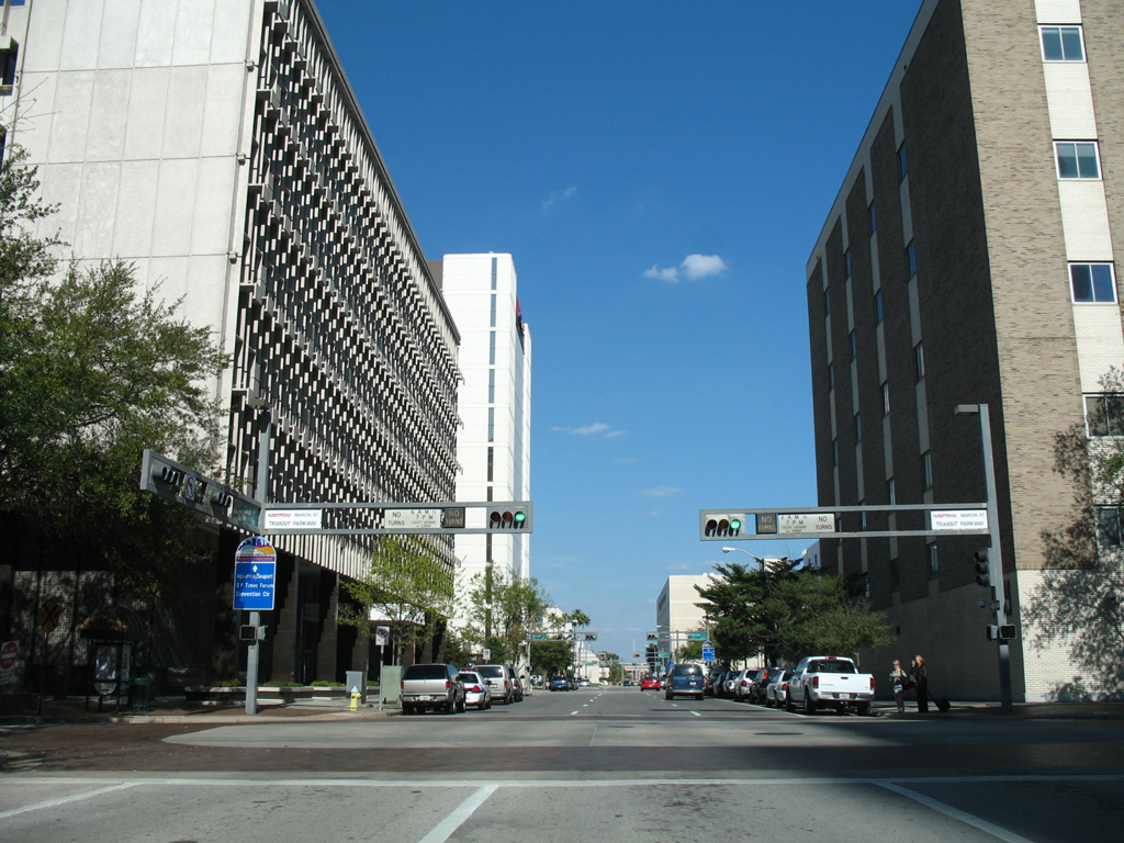
Marion Street, a transit-restricted street during the weekday hours, intersected Zack Street east in this scene. Wide sidewalks were added to both sides of Zack Street to Marion Street. The street east from here now carries two lanes with a center turn lane. 03/07/07
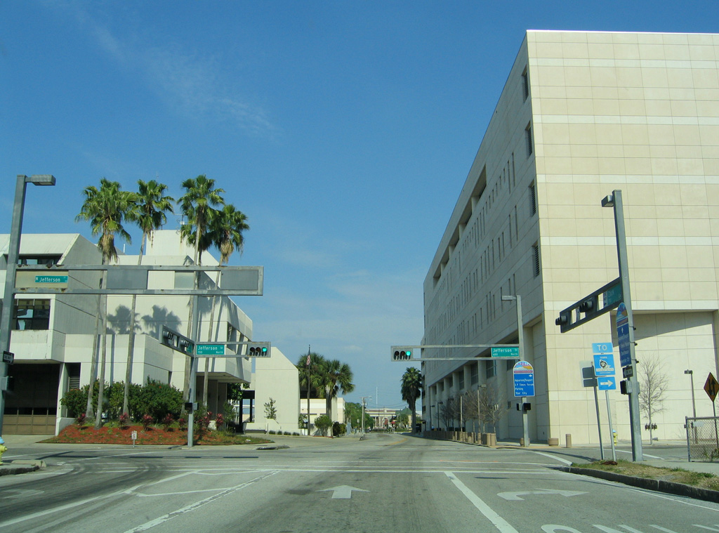
A Tampa Crosstown Expressway trailblazer pointed motorists southward on Jefferson Street on Zack Street east at the George E. Edgecomb Courthouse. 03/19/06