- Welcome to AARoads Forum.


News:
Thanks to everyone for the feedback on what errors you encountered from the forum database changes made in Fall 2023. Let us know if you discover anymore.


Recent posts
#1
Traffic Control / Re: Road Sign UNO
Last post by OracleUsr - Today at 02:26:08 PMQuote from: Jim on May 04, 2024, 08:45:50 AMTennessee 17 in Chattanooga. June 28, 2014.
Plus a big ice cream cone.
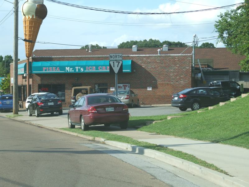
I presume that's an old Kay's Ice Cream (I remember that sign or something similar in Knoxville)
#2
Northeast / Re: General PA Design/Construc...
Last post by 74/171FAN - Today at 02:19:51 PM(For PA 715) PennDOT - District 5 News: New Route 715 Bridge is Open in Chestnuthill Township, Monroe County is Open
QuoteThe Pennsylvania Department of Transportation (PennDOT) Engineering District 5 announced today the new Route 715 bridge over McMichael Creek in Chestnuthill Township, Monroe County is open.
The old two-span stone masonry arch bridge was replaced with a single-span concrete arch culvert.
During constriction Route 715 was closed and detoured while crews replaced the bridge. Passenger vehicle traffic was detoured on Camp Akiba and Sterling roads.
Truck traffic was detoured on Sugar Hollow Road, State Road, Route 115, US 209, Greenview Drive and Neola Road.
Road-Con, Inc. of West Chester, PA was the general contractor on the $1,505,741 project that began in January.
The old Route 715 bridge was constructed in 1910. It was 23 feet long, 23 feet wide and was posted with a 15 ton weight restriction.
The new bridge is 32 feet long, 36 feet wide and has no weight restriction. This section of Route 715 has an average daily traffic volume of 5,245 vehicles.
For more information on projects occurring or being bid this year, those made possible by or accelerated by the state transportation funding plan (Act 89), or those on the department's Four and Twelve Year Plans, visit www.projects.penndot.gov.
Motorists can check conditions on major roadways by visiting www.511PA.com. 511PA, which is free and available 24 hours a day, provides traffic delay warnings, weather forecasts, traffic speed information and access to more than 1,000 traffic cameras.
Subscribe to PennDOT news and traffic alerts in Berks, Carbon, Lehigh, Monroe, Northampton and Schuylkill counties at www.penndot.govDistrict5.
Find PennDOT's planned and active construction projects at www.projects.penndot.gov.
Find PennDOT news on X, Facebook, and Instagram.
MEDIA CONTACT: Ronald J. Young, Jr., 610-871-4555, ronyoung@pa.gov; Sean A. Brown, 610-871-4556, sebrown@pa.gov.
#3
Northwest / Re: I-5 Columbia River Crossin...
Last post by Plutonic Panda - Today at 02:13:19 PMI had no clue they were going to toll the existing bridge while they construct the new bridge. Has that ever been done before?
https://mltnews.com/tolls-on-existing-i-5-bridge-will-help-pay-for-the-new-span-linking-oregon-and-washington/
https://mltnews.com/tolls-on-existing-i-5-bridge-will-help-pay-for-the-new-span-linking-oregon-and-washington/
#4
Off-Topic / Re: Most iconic news anchors i...
Last post by bing101 - Today at 02:11:29 PMSam Rubin of KTLA Los Angeles has died. Its not just Los Angeles that mourned him for his 33 years at the station but also in Australia and UK too given that his segments also aired there too.
#5
Off-Topic / Re: TV shows set in cities tha...
Last post by Plutonic Panda - Today at 02:09:22 PMQuote from: Max Rockatansky on Today at 02:00:07 PMYes I got that.Quote from: Plutonic Panda on Today at 01:57:56 PMQuote from: Max Rockatansky on Today at 09:14:00 AMThey never portray the path of travel as going anywhere near Las Vegas. The closest it probably gets is on US 62 (which is signed) in the beginning around El Paso.Don't worry, they used a control sign for OKC with the towering casinos and palm trees. Two cheers for climate change I guess?
Let me rephrase, it isn't presented as Las Vegas. It is crystal clear as part of the plot that they are in Oklahoma.
#6
Off-Topic / Re: TV shows set in cities tha...
Last post by SEWIGuy - Today at 02:06:29 PM"Step by Step" was a sitcom from the 1990s that was supposedly set in Port Washington, WI. The opening shows the family at an amusement park that is obviously not in Port Washington. Not even close.
https://www.youtube.com/watch?v=9g94bPMtxtM
https://www.youtube.com/watch?v=9g94bPMtxtM
#7
Off-Topic / Re: TV shows set in cities tha...
Last post by Max Rockatansky - Today at 02:00:07 PMQuote from: Plutonic Panda on Today at 01:57:56 PMQuote from: Max Rockatansky on Today at 09:14:00 AMThey never portray the path of travel as going anywhere near Las Vegas. The closest it probably gets is on US 62 (which is signed) in the beginning around El Paso.Don't worry, they used a control sign for OKC with the towering casinos and palm trees. Two cheers for climate change I guess?
Let me rephrase, it isn't presented as Las Vegas. It is crystal clear as part of the plot that they are in Oklahoma.
#8
Off-Topic / Re: TV shows set in cities tha...
Last post by Plutonic Panda - Today at 01:57:56 PMQuote from: Max Rockatansky on Today at 09:14:00 AMThey never portray the path of travel as going anywhere near Las Vegas. The closest it probably gets is on US 62 (which is signed) in the beginning around El Paso.Don't worry, they used a control sign for OKC with the towering casinos and palm trees. Two cheers for climate change I guess?
#9
General Highway Talk / Re: Crash prone 'modern rounda...
Last post by tradephoric - Today at 01:29:13 PMThe roundabout at Auburn & Main in Rockford is being converted from a double-lane to a single-lane roundabout. This is commonly the most crash-prone intersection in Rockford each year. Post conversion to a single-lane roundabout I doubt it makes the top 10 list.
Changes Coming To Auburn And Main Streets Roundabout In Effort To Reduce Crashes
https://www.rockrivercurrent.com/2024/05/17/rockford-to-change-auburn-and-main-streets-roundabout-to-reduce-number-of-crashes/
Changes Coming To Auburn And Main Streets Roundabout In Effort To Reduce Crashes
https://www.rockrivercurrent.com/2024/05/17/rockford-to-change-auburn-and-main-streets-roundabout-to-reduce-number-of-crashes/
#10
Traffic Control / Re: Guess the speed limit chal...
Last post by CovalenceSTU - Today at 01:19:15 PM30mph