- Welcome to AARoads Forum.


News:
Check out the AARoads Wiki!


Recent posts
#81
Pacific Southwest / Re: Closed Section of Route 39...
Last post by ClassicHasClass - October 17, 2025, 07:48:14 PMQuote from: cahwyguy on October 15, 2025, 11:12:29 PMQuote from: pderocco on October 15, 2025, 10:50:43 PMQuote from: Plutonic Panda on October 15, 2025, 06:38:16 PMI'm not gonna lie late at night one night, I was driving up Mulholland and I went to the trailhead near Encino Hills. The gate was open and I may or may not have driven halfway down the dirt portion until I got scared and I said yeah, this is probably not a good idea and I turned around. I kind of wish I would've completed it but it my gut told me it was not a good idea. I suspect the Rangers were probably on that trail and they were further down the path than I was.I drove it a couple times back in the early 80s, before it was closed. The turnoffs had great views of the SF Valley, but they were full of crushed beer cans and broken bottles.
Having grown up in the area (Palisades High), dirt Mulholland was a favorite "parking" spot. I'd imagine there's a lot of other ... debris.
The rubber certainly meets the road there.
#82
Photos, Videos, and More / Re: END signs
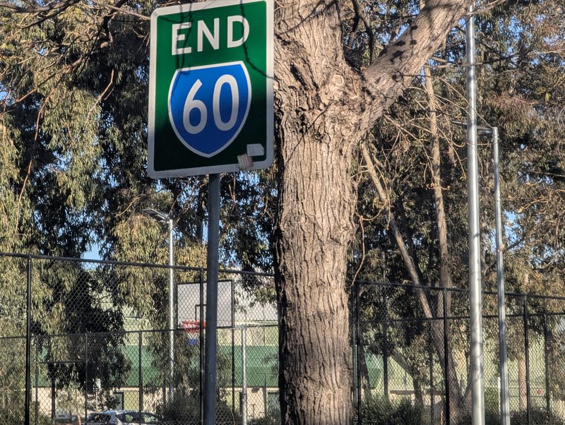
Last post by ClassicHasClass - October 17, 2025, 07:46:07 PMHow about an Australian highway END (not frequently posted)? Here's Melbourne urban route 60 ending just north of the UR 43/CityLink interchange. Quick shot out the passenger side since this sign is a bit hidden.
#83
Traffic Control / Re: Unique, Odd, or Interestin...
Last post by roadman65 - October 17, 2025, 07:44:10 PMQuote from: vtk on October 17, 2025, 06:22:48 PMColumbus has long been thought of as an ambiguous placename outside of Ohio. An impression that is no longer deserved, if it ever was to begin with, IMO.Understand the logic of it, but looks peculiar next unstated Cleveland. 😅
Washington of course because our nation's capital is nearby and served indirectly by I-270.
#84
Traffic Control / Re: 1-2-3 Route number Additio...
Last post by 74/171FAN - October 17, 2025, 06:37:17 PM1581=847+642+81+11 in Winchester, VA (SR 642 WB at VA 37 NB)
 SR 642 WEST NEAR VA 37 NORTH by Mark Moore, on Flickr
SR 642 WEST NEAR VA 37 NORTH by Mark Moore, on Flickr #85
Pacific Southwest / Re: California
Last post by DTComposer - October 17, 2025, 06:23:47 PMI checked the cities around me, and here's what I found:
San Jose: listed on signs at 94 feet. That doesn't correspond to current (2005) city hall or former (1958) city hall, but is pretty close to the 1889 city hall.
Los Gatos: listed on signs at 395 feet, corresponds to city hall (edge of CBD).
Santa Clara: listed on signs at 93 feet. Doesn't correspond to current or former city hall or central business district.
Saratoga: listed on signs at 500 feet. Doesn't correspond to current (1966) city hall, but does correspond to former (1956) city hall (edge of CBD).
Campbell: listed on signs at 190 feet. Corresponds closely to current city hall/downtown.
Monte Sereno: listed on signs at 502 feet. Doesn't correspond to city hall, but does correspond to the geographic center of the city (which is on private property).
So....sorta?
San Jose: listed on signs at 94 feet. That doesn't correspond to current (2005) city hall or former (1958) city hall, but is pretty close to the 1889 city hall.
Los Gatos: listed on signs at 395 feet, corresponds to city hall (edge of CBD).
Santa Clara: listed on signs at 93 feet. Doesn't correspond to current or former city hall or central business district.
Saratoga: listed on signs at 500 feet. Doesn't correspond to current (1966) city hall, but does correspond to former (1956) city hall (edge of CBD).
Campbell: listed on signs at 190 feet. Corresponds closely to current city hall/downtown.
Monte Sereno: listed on signs at 502 feet. Doesn't correspond to city hall, but does correspond to the geographic center of the city (which is on private property).
Quote from: RZF on October 17, 2025, 05:18:51 PMGoogle says it's the central business district or city hall building. Please fact check me...
So....sorta?
#86
Traffic Control / Re: Unique, Odd, or Interestin...
Last post by vtk - October 17, 2025, 06:22:48 PMColumbus has long been thought of as an ambiguous placename outside of Ohio. An impression that is no longer deserved, if it ever was to begin with, IMO.
#87
Great Lakes and Ohio Valley / Re: State Lays Out Vision for ...
Last post by vtk - October 17, 2025, 06:19:07 PMI called it on widening I-71, too
#88
Pacific Southwest / Re: Nevada SR-89 / Pole Line R...
Last post by FredAkbar - October 17, 2025, 05:56:21 PMQuote from: jander on October 17, 2025, 10:54:32 AMhttps://www.gaiagps.com/map/?loc=12.1/-121.7313/38.5393&pubLink=VaQbMfxhDD61UxZ4M9O532XS&trackId=5b0290aa0e74934947f4e1dfd01d0f95
I80 from SF to US-50 was miserable. It took hours. Stuck for 40 minutes in Davis. I hate this drive. 50 over the pass was fine, as was 395. Perfectly doable at night, the biggest issue was trying to keep my speed down.
The elevation on that tracking link says you got as high as 80,942 feet above sea level. It must have been hard to breathe!
#89
Mid-South / Re: I-35 Expansion in San Anto...
Last post by Chris - October 17, 2025, 05:54:15 PMAre there any good photos of this project?
Google Earth satellite imagery from March 2025 shows that some of the express lane viaducts are substantially underway around the Loop 1604 interchange, and columns for the viaducts on most of the route. I presume it has progressed further since then.
Google Earth satellite imagery from March 2025 shows that some of the express lane viaducts are substantially underway around the Loop 1604 interchange, and columns for the viaducts on most of the route. I presume it has progressed further since then.
#90
Great Lakes and Ohio Valley / Re: I-469/US 24 Ramp Construct...
Last post by tdindy88 - October 17, 2025, 05:25:01 PMQuote from: I-55 on October 17, 2025, 05:06:12 PMDrove through the interchange today. The new SB ramp to Rose Ave is now open (signed as exit 21B) and is serving as the ramp to US 24 east while construction wraps up on the SB Exit 21A ramp.
INDOT also gave us a little surprise. The SB Exit 21A signage includes Toledo as a control city. The signs NB do not include Toledo and I doubt they'll be replaced.
I saw signage plans for this project a while ago. I believe there are plans for Toledo to be added on the northbound signage as well.