December 2007
Monthly Archive
Mon 31 Dec 2007
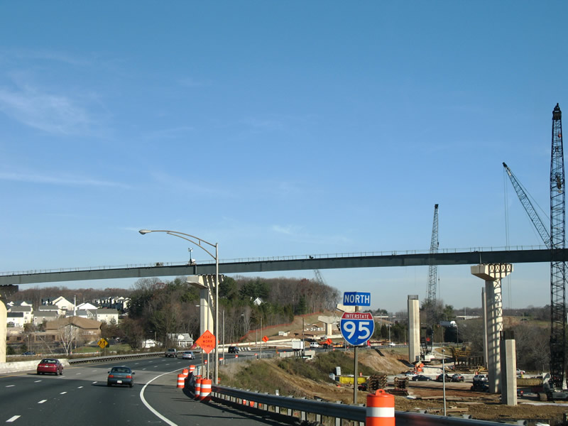
Constructed between August 2003 and October 2006, Maryland 43 (White Marsh Boulevard) was extended 3.8 miles from a premature end at U.S. 40 (Pulaski Highway) to Maryland 150 (Eastern Boulevard). The new state highway consists of a four-lane divided highway with expressway like characteristics. While there are no private driveways, seven at-grade intersections exist along the route to accommodate future development, including that with the proposed Campbell Boulevard.

Maryland 43 (Whitemarsh Boulevard) briefly exists as a freeway between Interstate 95 and U.S. 40. A full cloverleaf-interchange joins the freeway with Interstate 95 followed by a folded-diamond interchange at Maryland 7 (Philadelphia Road). The interchange between White Marsh Boulevard and Interstate 95 is in the process of upgrade to a directional-cloverleaf interchange associated with the Interstate 95 Express Toll Lane project. The missing sign pictured here once held a panel that displayed “Lane Ends 1000 Feet”.

Originally Maryland 43 ended at a partial trumpet interchange with U.S. 40. That connection was reconfigured into an at-grade intersection with a short access road joining both highways. 1970s highway maps show Maryland 43 proposed to the southeast as a freeway to Maryland 150.
The project opened to traffic on October 23, 2006 at a cost of $76.5 million with private contributions in the form of $2.4 million and 34 acres from the AV Williams Trust. The AV Williams Trust element results in the construction of four intersections to serve their land that is already accommodating new commercial development.

Maryland 43 (White Marsh Boulevard extended) eastbound at the future intersection with Campbell Boulevard. Rural lands surround the four-lane highway presently from U.S. 40 southward to Maryland 150 (Eastern Boulevard). Visible in the distance is a clearing associated with new commercial development at the AV Williams Trust land.
(more…)
Sun 30 Dec 2007
Yesterday I had the opportunity to revisit the Blue Ball project of U.S. 202 north of Wilmington, DE. I thought that most of the U.S. 202 work was completed by May, but much to my surprise, a few more things were tweaked road and signwise.
Now travelers heading north from Wilmington via Concord Avenue (Delaware 202) remain segregated from merging traffic from Interstate 95 until after the Foulk Road (new Delaware 141 and Delaware 261) off-ramp. Additonally the Augustine Cutoff intersection is limited to just two movements now, from Delaware 202 north to it and from it to U.S. 202 south. These projects precede work at the Interstate 95 interchange that will eliminate the southbound loop ramp to Delaware 202 by adding a left-hand movement from the northbound ramp to Concord Avenue south. Work on the ramp conversion is already underway.
New overheads are up along the U.S. 202 northbound off-ramp from Interstate 95, including a set of diagrammaticals for the Foulk Road off-ramp. Additionally the one-lane directional ramp from northbound now widens to two lanes before joining Concord Pike, a new change from the original design.

Southbound overheads were completely replaced now and unfortunately omit U.S. 202 southbound’s merge onto Interstate 95 south. Signs just indicate Interstate 95 south, and a token U.S. 202 south arrow shield lies just ahead of the ramp. If U.S. 202’s merge with Interstate 95 is being downplayed, why not truncate it back to this interchange or to the U.S. 13 Business intersection at Market Street?

I checked just south of the Interstate 95 southbound off-ramp and the end U.S. 202/begin Delaware 202 assembly is still there. Which leads me to my next observation, the pull-through panels along Concord Pike south that now simply display “Wilmington”. No mention of Delaware 202 or Concord Avenue, just the control city. This is sort of a disservice to area motorists who may be destined to downtown or other parts of the city, yet the sign does not indicate anything other than the city. Concord Avenue does provide a way to downtown via Baynard Boulevard, but it is not a commercial route and if you are not familiar with the area, you may get lost and unfortunately the adjoining neighborhoods at Market Street are home to drive by shootings and other crime. If Delaware 202 is so confusing, then why not choose a new number or decommission it? What other instance does a U.S. highway split with its old route that carries the same number anyway?

For additional photos see:
U.S. 202 Delaware @ AARoads
Delaware 202 @ AARoads
Blue Ball @ AARoads
Also I hate to report it, but Interstate 95 signs for the Delaware 1 & 7 interchange were carbon copied and therefore still make no mentioning of Dover! They did add the DelDOT beach chair logo, which is supposed to convey to motorists that the road connects with the Delaware beaches. Otherwise you will still think that the 51-mile freeway only connects to “Christiana Mall Road”, which should be referenced on auxiliary signs, since Christiana and Mall Road are separate destinations…
Lastly, Delaware has uploaded portions of its Manual of Uniform Traffic Devices. Much to my surprise, the document makes no reference to the use of MUST EXIT on overhead guide signs! Even more surprising are that the rules on freeway guide signs appear to be decent, with rules against sign clutter and what styles to use. Unfortunately in the field, the sign gluttoning continues and whats with every road now being signed as an evacuation route anyway? For what are we evacuating? Hurricanes, the Salem Nuclear Power plant, insect swarms? I asked one of my best friends if he has ever evacuated in 33 years of living here and he said no. So why do we now need these signs posted on every state road in northern Delaware?
Thu 20 Dec 2007
A $1 billion project is underway in the state of Maryland along Interstate 95. Being constructed are the Interstate 95 Express Toll Lanes. Beginning at the Interstate 895 merge in Baltimore and ending at the Joppatowne Road overpass, the express toll lanes project will widen Interstate 95 from eight general purpose lanes to eight general purpose lanes and four tolled express lanes.
Elements of the project include the reconstruction of the Interstate 95/895 partial “Y” interchange to relocate the Interstate 895 southbound split from a left-hand to a right-hand ramp and the addition of direct ramps between Interstate 895 and the new express toll lanes. Work began on this project in October 2006 and should be completed by October 2008.

Merging with Interstate 895 north from Interstate 95 north in Baltimore. Construction of the new flyover that will carry Interstate 895 north onto the general purpose lanes of Interstate 95 is well underway.
Further east, the symmetrical directional interchange with Interstate 695 will be completely redesigned into that of a high-speed stack interchange, with connections to both the Interstate 95 mainline and the inner express lanes. Reconfiguration of this interchange will eliminate all of the left-hand movements drivers presently encounter. Phase one of the project began on January 22, 2007 to build a symmetrical stack interchange between the general purpose lanes of Interstate 95 and Interstate 695. Completion is expected in 2010. Phase two, the building of ramps between the new express toll lanes and Interstate 695, as scheduled will begin in May 2008 and end by June 2011.

Towering pillars and the future flyover between Interstate 95 north and Interstate 695 rise above the present interchange in east Baltimore.

Looking north along Interstate 95 at new flyovers to Interstate 695 north from Interstate 95 north and Interstate 695 south to Interstate 95 north. These ramps are slated to open in 2010.
Beginning in Spring 2008, crews will expand their focus to the Interstate 95 interchange with Maryland 43, a current full-cloverleaf interchange. Work includes widening of 1.1 miles of Maryland 43 from four to six lanes and rebuilding of the interchange with directional ramps from the Interstate 95 general purpose lanes and additional ramps from the express toll lanes. Work will take three years to complete.
And we can now add Maryland to the list of states that now use Clearview…

Interstate 95 northbound approaching Maryland 2 (Exit 54) south. The entire Exit 54 features Clearview, including the Maryland 2 shield.
Thu 20 Dec 2007
One of the newest freeways planned in Florida is that of the Branan Field-Chaffee Expressway, State Road 23. Running north-south between Florida 21 (Blanding Boulevard) and Interstate 10, the four-lane freeway is presently either under construction or in the design stages. Beginning in Middleburg, a two-lane surface highway leads north from Blanding Boulevard to the Clay County line. Portions of this roadway lie within or along the freeway right-of-way, other sections will be bypassed by a new four-lane alignment. Interchanges planned include those with Florida 21, the future College Drive North extension, and Argyle Forest Boulevard near the county line.

Branan Field Road (future Florida 23) northbound at the Duval County line. Presently the roadway carries two lanes of traffic between Florida 21 (Blanding Boulevard) and Argyle Forest Boulevard. Signs along the two-lane portion reference the Limited Access Right of Way and list (904)360-5200 as the number to call for information.
Northward into Duval County, Florida 23 exists partly as a two-lane roadway, partly as a controlled-access expressway, and partly as a new alignment currently under construction. Signed Florida 23 follows Chaffee Road northward to Florida 134 (103rd Street). Beyond the intersection with 103rd Street, Florida 23 veers northwest onto a new alignment, presently under construction, to Interstate 10 and U.S. 90. The planned Duval County four-lane freeway includes interchanges with Florida 228 (Normandy Boulevard), New World Avenue, Interstate 10, and U.S. 90.

Florida 23 northbound reassurance marker, the first of two, posted after the signalized intersection with Argyle Forest Boulevard east and Oakleaf Plantation Parkway west. Four-laning of this portion of expressway awaits the completion of interchanges.
The overall project represents the northern leg of the proposed First Coast Outer Beltway, a freeway/tollway project linking Interstate 10 in west Duval County with Interstate 95 in St. Johns County. Florida 23’s south end will transition into the beltway as it turns east toward a crossing of the St. Johns River. The east-west portion of highway will likely be funded with tolls.
In 2001, a two-lane roadway opened between Florida 21 (Blanding Boulevard) and Florida 134 (103rd Street). This roadway included portions of pre-existing Branan Field Road in Clay County and links directly with Chaffee Road north of 103rd Street. Widening of the roadway between Argyle Forest Boulevard and 103rd Street followed, bringing the highway up to a four-lane controlled-access expressway.

Florida 23 (Chaffee Road) northbound at the beginning of construction for the new alignment northwest to Interstate 10. The two to four lane alignment travels through the former Cecil Field Naval Air Station en route to Interstate 10; Chaffee Road continues otherwise to its own diamond interchange with the freeway.
Work commenced on January 16, 2007 on the northernmost portions of the Branan Field-Chaffee Expressway project. Elements of this work include the building of a two-lane roadway linking Florida 23 north of Florida 134 with New World Drive, and a four-lane roadway between New World Drive and the new interchange with Interstate 10. Work on this 4.8-mile segment is slated for completion in fall 2009. Additional work will four-lane the new Florida 23 between New World Drive and Florida 104, creating a four-lane at-grade controlled-access expressway from Interstate 10 to Argyle Forest Boulevard. Future four-laning of the current roadway leading southward into Clay County is planned, but these elements and the four-laning between New World Drive and Florida 104 remain unfunded at this time.
Interchanges along the eventual freeway are planned for beyond the time it takes to four-lane the Florida 23 alignment.
Wed 19 Dec 2007

I had the chance to check out and clinch the new Interstate 795 this week in North Carolina. With the early sunsets and low sun angle, I almost missed out, but for a preview of the northbound side of the freeway, see our new Interstate 795 guide at southeastroads.
And for some photos covering the south end, see U.S. 70 North Carolina @ Southeastroads.
Sat 15 Dec 2007
They are appearing in a town near you!

We found a few instances of the new highway sign this weekend including a South Carolina 303 shield in Walterboro and several South Carolina 6 shields in Moncks Corner.

It appears that the standard 3di-width shield will be used as the default for all shields, as every shield for South Carolina 6 and South Carolina 6 Truck used the same base.
Thu 13 Dec 2007
This past weekend afforded me with the opportunity to check on the status of some upper Gulf Coast road projects related to the recovery from Hurricane Katrina. The August 29, 2005 landfall of the historic storm not only devastated the New Orleans and Mississippi coastal area homes and businesses, but also washed out several key stretches of highway infrastructure. Included in the storm’s fury was the destruction of the U.S. 90 spans over both Biloxi Bay at Ocean Springs and St. Louis Bay and the collapse of the Interstate 10 twin spans over Lake Pontchartrain. Now over two years removed, recovery efforts are well underway!
Beginning in the east, the U.S. 90 Ocean Springs Bridge is finally open to traffic after 18 months of work. Initially opened to traffic on November 1, 2007, the bridge presently carries two lanes of traffic on a span that eventually will accommodate six lanes and a pedestrian/bicycle path. The span travels much higher than the original four-lane crossing, thus negating the need for a draw-span. See MDOT’s BiloxiBayBridge page for more details on the construction, which is slated for completion on April 16, 2008, with a full bridge opening on March 28, 2008. Work began on June 16, 2006.

U.S. 90 first spans the CSX Railroad line over an arm of the Old Fort Bayou before ascending along the high-level Biloxi Bay Bridge. Features of the new span include a retro-style guard rail and light yellow paint motif.
Continuing west, the destruction wrought by Hurricane Katrina becomes increasingly evident as one leaves Biloxi and enters Gulfport, Long Beach, and Pass Christian. Presently crews are repaving the U.S. 90 roadway, which remains somewhat bumpy after the Hurricane.
Some new development has occurred on the stretch, but much of it remains abandoned or clear of any structures. One such structure that was replaced is the St. Louis Bay Bridge of U.S. 90. Crews opened half of the eventual four-lane bridge on May 17, 2007, linking the city of Bay St. Louis with Pass Christian. As of December 10, 2007, the span still carries two-lanes and a 12-foot pedestrian/bicycle path.

U.S. 90 westbound on the St. Louis Bay Bridge – December 10, 2007. Traffic shifted from the completed eastbound lanes onto the westbound lanes on November 26, 2007 so that contractors could finish the final elements of the bridge including lighting, signs, and railing.
Construction on the St. Louis Bay Bridge commenced on June 7, 2006, just three months after demolition began on the remnants of the original span. U.S. 90 originally traveled along a two four-lane draw bridge, but with an 85 foot clearance on the new span, motorists will not longer suffer delays from marine traffic below. The $266.8 million project is near completion.
U.S. 90 remains a somewhat lonely road from its partition with Mississippi 607 in western Hancock County. Continuing from there through the Pearlington area, a series of truss, lift, and pony truss bridges carry the two-lane highway through bayou country. Once U.S. 90 nears the Rigolets, a waterway that joins Lake Pontchartrain to the west with Lake Borgne to the east, another bridge project is well underway. Crossing the Rigolets is the narrow two-lane Fort Pike Bridge, a truss with a swing span first opened to traffic in 1930.
The stretch of U.S. 90 suffered damaged due to Katrina’s storm surge, however the bridge suffered limited damage structurally (but major damage to its electrical system). LADOTD’s replacement project of the aging span was already underway when Hurricane Katrina made landfall. However contractors working on the span were pulled away from the project for emergency repairs to the Interstate 10 bridges over Escambia Bay after Hurricane Ivan.

Looking east at the original Fort Pike Bridge and its future replacement at the Rigolets in eastern Orleans Parish.
A three-year construction project is underway to build a 5,500-long span with a 70 foot clearance. No longer will motorists experience anxiety when crossing the waterway on 10 feet lanes as the new bridge will carry two 12 foot lanes with 12 foot shoulders. Work began on the $50.6-million project November 2004 with an expected completion by June 2008.
Another of the three crossings between Orleans and St. Tammany Parish is that of the twin bridges of Interstate 10 over Lake Pontchartrain. These, like those of Interstate 10’s crossing of Escambia Bay in Florida, suffered the same fate of the U.S. 90 bridges in Mississippi with storm surges higher than the bridge itself toppling the concrete decks into the lake waters below. For a short time period, there was no Interstate 10 crossing between New Orleans and Slidell, with the narrow U.S. 11 bridge carrying the entire load. However an interim solution arose that salvaged submerged bridge deck components in conjunction with temporary metal-deck trusses.
Currently Interstate 10 traffic still utilizes a combination of the original bridges and those temporary metal trusses, similar to what travelers endured for several years at Pensacola. Construction is well underway however on the eventual replacement of the original four lane crossing with a much higher set of three lane bridges along the eastbound side. Costing $800-million, the twin-span replacement project will result in bridges ranging between 15 and 28 feet higher than the original bridges. Opening of the future westbound bridge is expected by late 2009. That span will carry four lanes of travel as crews work on the two-year completion of the new eastbound bridge.

Spanning Interstate 10 along U.S. 11 at Irish Bayou. Work on the Interstate 10 replacement spans is still in the early stages.
Four overall lanes of traffic are still accommodated along the 1965-built bridges. When the westbound bridge opens in 2009, demolition will begin on the original spans.
In related news, crews put the finishing touches on the new westbound bridge carrying Interstate 10 across Escambia Bay this week (December 12, 2007). Work was planned for completion by Christmas, but now cross country travelers and commuters alike will reap the benefits of the three-year $245-million construction job done in the wake of Hurricane Ivan. The new spans travel 25 feet higher than original shoulder less two-lane bridges. Drivers may now safely span Escambia Bay along three overall lanes per direction that includes shoulders on both the inside and outside lanes.

A look at the Escambia Bay Bridge project just four days prior to the opening of the new westbound bridge. Portions of the original bridge are being used to create an artificial reef in the offshore waters of the Gulf of Mexico.
As it stands now, the bridge carries six overall lanes across the bay. Eastbound traffic reduces to two lanes once reaching land in Santa Rosa County. The third westbound lane becomes exit-only for the U.S. 90 (Exit 17) folded-diamond interchange. It is expected that Interstate 10 will be widened to six-lanes overall between Exit 17 and Exit 13 (Florida 291 / Davis Highway) in the near future.
Sources:
Reconstruction Of The Bay St. Louis Bridge - MDOT
“Top Louisiana Construction Projects (2005),” McGraw-Hill Construction.
“Gov reopens I-10 bridge.” Pensacola News Journal, December 12, 2007.
Wed 5 Dec 2007
Officials hoped to open Interstate 99 on December 2, but a delay in the installation of highway signs pushed that date back to a time between December 12 and 19. When it opens, northbound drivers will be able to seamlessly travel from Bald Eagle to State College Skytop / Port Matilda along new freeway. Southbound drivers however must wait until mid-2008 to fully use the freeway, as crews continue to remove acid rock from the Skytop area north of Port Matilda.
The acid rock removal affects the Interstate 99 interchange with U.S. 322 at Port Matilda, where Interstate 99 north merges with U.S. 322 east. All northbound traffic will be squeezed to one through lane via a temporary configuration until the completion of the acid rock removal process. Interstate 99 south will begin at the High Street diamond interchange west of Port Matilda.

U.S. 220 south & 322 (Eagle Valley Road) west at the Interstate 99 bridge over Bald Eagle Creek and Eagle Valley Road northeast of Port Matilda during construction. Interstate 99 bypasses Port Matilda to the north before crossing over U.S. 220 & 322 onto Eagle Mountain to the east. Photo taken 04/30/05.
Opening of the highway project, despite the acid rock removal, was advocated by State Rep. Rick Geist (R-Altoona) in effort to improve access to State College, its economic development, and safety along the previous two-lane U.S. 220 corridor.

A diamond interchange lies west of Port Matilda, joining Interstate 99 with High Street (U.S. 322). Just north of there is the Laurel Run bridge and merge with the U.S. 322 eastbound freeway. The acid rock removal site lies along the freeway between the U.S. 322 interchange and the Eagle Valley Road under crossing. Photo taken 04/30/05.
The acid rock resulted from an unearthing of sandstone laced with pyrite in 2003. Large amounts of the pyrite-laced sandstone were found at the project site near Port Matilda (Skytop), which when exposed to air and water created sulfuric acid. A now $79-million project began to remove the acid rock from the construction area, causing delays in overall completion and escalation of construction costs.

Interstate 99 turns southward from west of Port Matilda back onto Eagle Mountain. Pictured here are bridge supports for the Interstate 99 span over U.S. 220 (Eagle Valley Road), Bald Eagle Creek, and the Nittany & Bald Eagle Railroad. Photo taken 04/30/05.
More information on Interstate 99 is available at Interstate 99 @ Interstate-Guide.
Sources:
“Interstate 99 opening delayed.” The Altoona Mirror, December 1, 2007.
“Cost of Interstate 99 acid cleanup rises to $50.5 million.) Wilkes Barre Times-Leader, December 5, 2007.
Wed 5 Dec 2007
It was 1992 when I first noticed large mounds of dirt rising within the cloverleaf ramps of the Interstate 95 interchange with Delaware 7 and then fledgling-Delaware 1. The mounds were created in anticipation of a planned interchange upgrade between the Delaware Turnpike and new SR 1 Turnpike. 15 years later, the mounds remain, covered with vegetation and even a growing tree if I remember correctly.

Delaware 1 & 7 northbound at the Mall Road overpass, south of the interchange with Interstate 95. One of the aforementioned dirt mounds rises in the background (left of the right-hand side bridge supports).
Earlier this year DelDOT began a project that involves the widening of Interstate 95 through Christina Marsh. Presently the turnpike carries four lanes per direction with full inside and outside shoulders. The project is the first step taken by the state to undo years of growing congestion on the busy Interstate corridor.
The ten-laning project, if you will, will see the expansion of the freeway outward through the wetlands area; no expansion can occur within the inside lanes as a jersey barrier represents the median. Interstate 95 will carry ten lanes between Delaware 1 & 7 and the split with Interstate 295 upon completion. The new lanes will directly tie into the existing full-cloverleaf interchange between the SR 1 Turnpike and Delaware Turnpike. Completion is anticipated in 2010.
When work completes through the marsh, DelDOT hopes to break ground on a project to upgrade the failing cloverleaf interchange between Interstate 95 and Delaware 1 & 7. This much needed project has origins in the early 1990s!
Funding woes have long been an issue beleaguering the Delaware Department of Transportation. No matter how many toll increases or other fee additions come into existence, the state continues to operate at a major shortfall. An August 13, 1992 News Journal (Wilmington, DE) article entitled “Big road jobs delayed” references a funding shortage that pushed the Interstate 95/Delaware 1 & 7 interchange back from 1995-96 to 1996-97. Ten years later, no work has yet started!
A look at the revamped DelDOT website and its SR7/I-95 project website now indicates a four-year construction project that may begin in 2011, when funding becomes available. Additionally the site states “Increasing traffic volumes and development south of SR 1 has led to deteriorating levels of service within the area of Christiana Mall and the I-95/SR 1 Interchange. While morning and evening peaks continue to struggle, this area also has deteriorating traffic conditions at many other times of the day and often throughout weekends. On most days many of the ramps experience levels of service (LOS) F.” An increase of Interstate 95 tolls from $3.00 to $4.00 per passenger vehicle on October 1, 2007 was passed to help cover the funding, but that money pays for projects throughout the state, not just those associated with Interstate 95.
So with something that is obvious to anyone who drives the interchange on a daily basis, or even once or twice a month, there is a problem and there has been one for 15 years! I find a 19-year delay between the arrival of dirt within the loop ramps and bulldozers to flatten it to be just mind-blowing. Factor in a four-year construction project, and its 2015 when any relief is given to the 250,000 plus motorists that use the junction.

According to 2006 traffic counts, 182,853 vehicles a day traveled Interstate 95 between Delaware 1 & 7 and Interstate 295. 76,784 motorists utilized Delaware 1 between Delaware 273 and Interstate 95.
If matters were not worse, developers plan on expanding the burgeoning Christiana Mall commericial district by another 900,000 square feet in the form of the Christiana Fashion Center. Just west of the area, between Delaware 7 and 273, an additional 600,000 square feet of new commercial development is also proposed. With Delaware not levying sales tax, shoppers will add to the fray of an already awful situation on the roads at Interstate 95 and Delaware 1. Who wants to bet that the retail development will be completed before the interchange upgrade?
Additional sources:
“Christiana plan could lead to traffic jam.” The News Journal (Wilmington, DE), October 14, 2007
Mon 3 Dec 2007
Posted by Kevin under
Arizona1 Comment
U.S. Highway 191 travels along the eastern boundary of Arizona between Arizona 80 near Douglas and U.S. Highway 160 at Mexican Water. AARoads recently took a trip on the road from Interstate 10 to U.S. 60 in Springerville, encompassing the Coronado Trail.
The Coronado Trail was constructed between Clifton and Alpine in 1926, and added to the state highway system as U.S. 666 in 1938. The road remained essentially unpaved until 1963, when it was fully paved. The Coronado Trail is well known for the twists and turns – some have counted over 400 curves between Clifton and Alpine, where the road climbs almost 5800 feet in altitude from Clifton north.

U.S. Highway 191 has numerous tight turns like this one inside Chase Creek.
For more, visit U.S. Highway 191 (Clifton to Alpine) on RockyMountainRoads.com.
Next Page »