

California 1 South - Monterey County
| California 1 south | |
|---|---|
 |
Southbound California 1 meets Exit 404, Sand City. Yes, even in mid-summer, the central California coast can be cloudy and foggy. Photo taken 08/18/03. |
 |
Photo taken 05/28/03 by Pete Sison. |
 |
The next exit along California 1 (Cabrillo Highway) south is Exit 403, California 218 east (1.25 miles). Photo taken 08/18/03. |
 |
View of the ocean along southbound California 1 in Seaside just north of the California 218 exit. Photo taken 08/18/03. |
 |
Southbound California 1 approaches Exit 403, eastbound California 218, Seaside and Del Rey Oaks, next right. Photo taken 08/18/03. |
 |
Photo taken 05/28/03 by Pete Sison. |
 |
Southbound California 1 reaches Exit 402B, Del Monte Avenue/Pacific Grove. Yes, this exit leads into Monterey/Pacific Grove, but it may not be the best route to reach all areas of town - consult a map beforehand. Photo taken 08/18/03. |
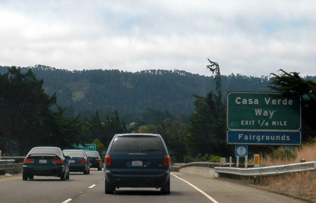 |
The next exit along California 1 (Cabrillo Highway) south is Exit 402A, Casa Verde Way, one-quarter mile. Photo taken 08/18/03. |
 |
The next exit along California 1 (Cabrillo Highway) south is Exit 401B, California 68 east. From this interchange, California 68/Salinas Highway follows a mostly two-lane route east to Salinas and U.S. 101; westbound California 68 merges onto southbound California 1 for a few miles to provide a back route into Monterey. Photo taken 08/18/03. |
 |
Southbound California 1 meets Exit 401B, California 68 east. California 68 west merges onto southbound California 1, parting ways at the southern city limits of Monterey. The next exit after California 68 east is Exit 401A, California 1 Business/Fremont Avenue south. Photo taken 05/28/03 by Pete Sison. |
| California 1 (Cabrillo Highway) south and California 68 west | |
 |
Soon after merging together, southbound California 1 and westbound California 68 approach Exit 401A, California 1 Business southwest into Monterey. This is the main exit into Monterey. Photo taken 08/18/03. |
 |
Immediately thereafter, southbound California 1 and westbound California 68 meet Exit 401A, southbound California 1 Business into Monterey. This exit is the primary route to all the main urban features of Monterey, including downtown, Cannery Row, and the Monterey Bay Aquarium. Photo taken 08/18/03. |
 |
Westbound California 68 travels east toward the Asilomar state conference grounds, with a connection to the world-famous, scenic 17-Mile Drive toll road, which connects to the Lone Cypress, the world famous Pebble Beach golf course, and a variety of resorts and other golf courses. Photo taken 08/18/03. |
 |
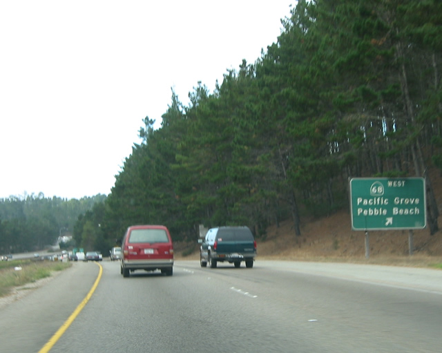
The next exit along California 1 south is Exit 399A, westbound California 68. California 68 leads to Pacific Grove, Monterey, and Asilomar. In addition, it connects to the scenic 17-Mile Drive toll road as well as the world famous Pebble Beach golf course. The freeway ends after this exit, and it assumes a totally different character once it passes through Carmel. Photo taken 08/18/03. |
 |
Southbound California 1 meets Exit 399A, west California 68 (W.R. Holman Highway). Use Exit 399A to follow California 68 to the Highway One Gate of the famous 17 Mile Drive. The 17 Mile Drive passes through Del Monte Forest, connecting several golf courses and residences together on one of the world's most scenic drives. It is well worth the toll. Photo taken 05/28/03 by Pete Sison. |
 |
Finally, southbound California 1 and westbound California 68 divide. California 68 heads northwest from this point, following the W.R. Holman Highway into Pacific Grove, where it becomes Sunset Drive. Turning right (north) on Asilomar Avenue, California 68 reaches its western terminus at the intersection of Asilomar Avenue and Lighthouse Avenue in Pacific Grove, adjacent to Asilomar State Beach and the Point Pinos Lighthouse. Too bad California 68 isn't a longer highway that would more richly deserve such a dramatic ending. Photo taken 05/28/03 by Pete Sison. |
| California 1 south | |
 |
Now reaching the coastline, California 1 is now a two-lane highway passing through unpopulated areas in some of the most scenic areas of the state. A fog bank (coastal eddy) has formed off the coast near California 1. This kind of weather pattern is possible all through the year along California's coastline, especially when an on-shore flow brings cool moist air in contact with hot, dry air from the interior. It is not uncommon to witness cloudy, cool days along the coast even in the summer. Photo taken 08/18/03. |
 |
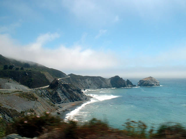
As southbound California 1 follows the craggy coastline near Big Sur south of Monterey/Carmel, the pictures describe the terrain and scenery much better than words. Photo taken 08/18/03. |
 |
Southbound California 1 crosses Rocky Creek Bridge. This concrete arch bridge was constructed and opened to traffic in 1932. Photo taken 08/18/03. |
 |
The Big Sur is one of the most scenic drives in the United States. As Southbound California 1 moves up and down coastal hills, passing through scenic pockets of forests, stunning views of the ocean are common, including incredible segments of highway that defy a written description. Dubbed an "All-American Road," California 1 is one of a kind with its sweeping vistas, numerous panoramas of the ocean and mountains, and craggy cliffs that give way to salty air and water. Note on the mileage sign that the control city for southbound California 1 becomes Hearst Castle, the famous residence of the late newspaperman, William Randolph Hearst. A side trip into Hearst Castle is highly recommended for travelers of California 1 through the Big Sur. This suite of photos was taken on 08/18/03. |
 |
 |
 |
|
 |
 |
|
 |
 |

Page Updated June 29, 2009.
|
About Contact Glossary |
In The News Testimonials Interstate Guide |
Social Media:
 |
|
© 2000-23 AARoads.com | All Rights Reserved | Privacy Policy / Terms of Use
|
||