
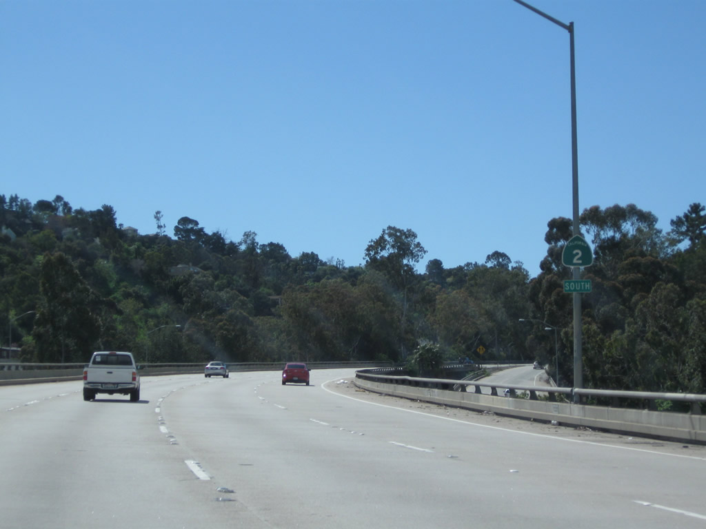
California 2 West
| California 2 south | |
|---|---|
 |
The Glendale Freeway begins at its intersection with Foothill Boulevard in La Canada Flintridge. The freeway travels due south through Glendale, then connects with Interstate 5 near Echo Park in Los Angeles. The cardinal direction for California 2 changes from west to south for the length of the freeway. Photo taken 03/25/07. |
 |
A begin freeway sign is posted after the freeway entrance shield assembly. California 2 will travel south over Interstate 210 and then join traffic from Interstate 210 en route to Glendale. Photo taken 03/25/07. |
 |
Southbound California 2 (Glendale Freeway) carries two lanes until it joins with other lanes from Interstate 210. California 2 leaves La Canada Flintridge and enters the city of Glendale (population 194,973 as of 2000 Census and incorporated on February 15, 1906). Photo taken 03/25/07. |
 |
The on-ramp to Glendale Freeway south narrows to one lane, then merges with traffic coming from Interstate 210 east. Photo taken 03/25/07. |
 |
California 2 continues south as a freeway with four southbound lanes. Photo taken 03/25/07. |
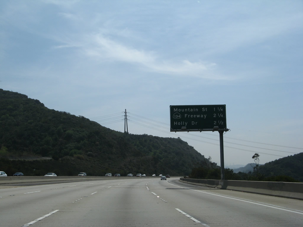 |
This mileage sign along California 2 (Glendale Freeway) south provides the distance to the next three exits: Exit 18, Mountain Street; Exit 17B, California 134 (Ventura Freeway); and Exit 17A, Holly Drive. Photo taken 03/25/07. |
 |
The next exit along California 2 (Glendale Freeway) south (west) is Exit 18, Mountain Street (0.75 mile). Photo taken 03/25/07. |
 |
Southbound (westbound) California 2 (Glendale Freeway) meets Exit 18, Mountain Street. Photo taken 03/25/07. |
 |
The next exit along California 2 (Glendale Freeway) south (west) is Exit 17B, California 134 (Ventura Freeway). The left four lanes continue southwest on California 2. California 134 is a major east-west freeway connecting Interstate 210 in Pasadena with U.S. 101 in North Hollywood. Photo taken 03/25/07. |
 |
After Exit 17B (California 134 (Ventura Freeway)), the second exit is Exit 17A, Holly Drive to Eagle Rock (part of the city of Los Angeles). Photo taken 03/25/07. |
 |
Westbound (southbound) California 2 (Glendale Freeway) meets Exit 17B, California 134 (Ventura Freeway). Use California 134 east to Interstate 210 in Pasadena to San Bernardino or west to U.S. 101 in North Hollywood en route to Ventura and Santa Barbara. Photo taken 03/25/07. |
 |
Soon thereafter, southbound California 2 (Glendale Freeway) meets Exit 17A, Holly Drive to Eagle Rock and Glendale. Photo taken 03/25/07. |
 |
California 2 (Glendale Freeway) leaves Glendale and enters the city of Los Angeles. Photo taken 09/25/05. |
 |
 |
 |
 |
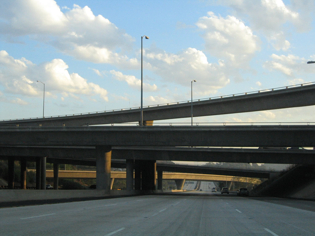
Southbound California 2 (Glendale Freeway) passes through the California 134 interchange, including a series of flyover ramps that pass over the mainline freeway. Photos taken 09/25/05. |
 |
Leaving the California 134 (Ventura Freeway) interchange and entering the city of Los Angeles, the next exit along California 2 (Glendale Freeway) west (south) is Exit 15B, York Boulevard. Photo taken 02/26/11. |
 |
This interchange sequence sign along California 2 (Glendale Freeway) west (south) provides the distance to the next three exits: Exit 15B, York Boulevard; Exit 15A, Verdugo Road; and Exit 14, Historic San Fernando Road (old U.S. 6-99) (former Business Loop I-5). While many historic U.S. routes used to permeate greater Los Angeles, most of those routes have been decommissioned (excluding U.S. 101, which remains on its current freeway alignment). However, many significant arterials and other highways previously served as a U.S. highway, including historic San Fernando Road. Photo taken 02/26/11. |
 |
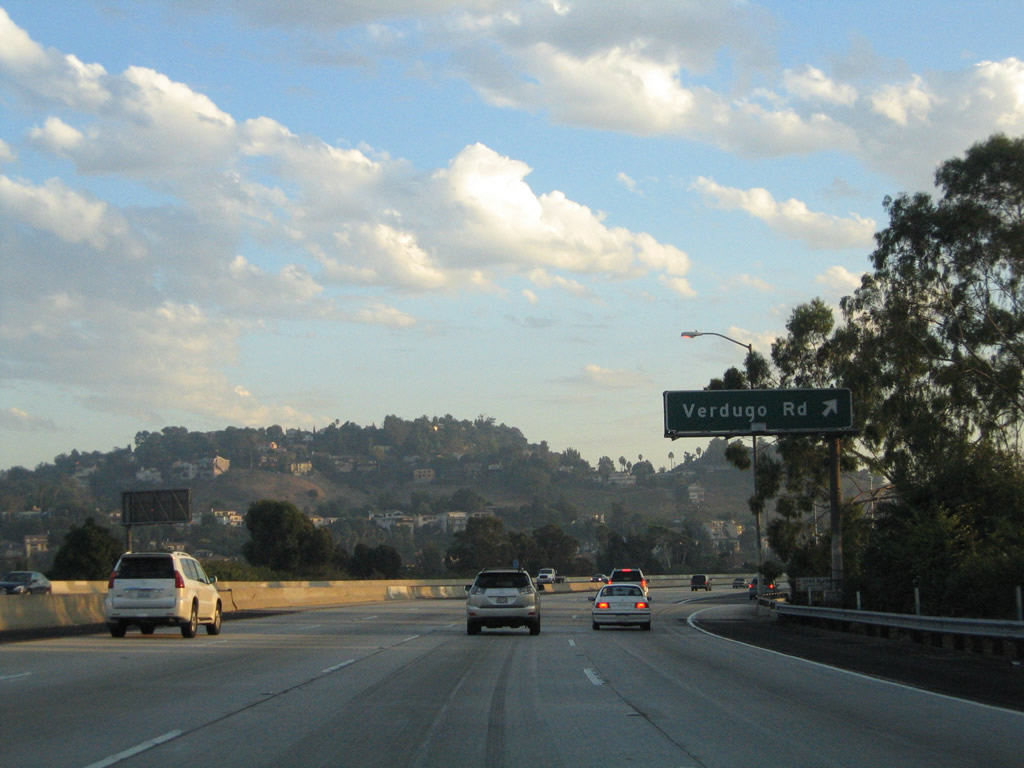
Westbound (southbound) California 2 (Glendale Freeway) meets Exit 15B, York Boulevard, which travels southeast toward the Highland Park community of the city of Los Angeles. York Boulevard also travels west to connect with Verdugo Road, the old alignment of California 2. The section of California 2 between California 134 and San Fernando Road (old U.S. 6-99) was built in 1976. Photo taken 02/26/11. |
 |
The next two off-ramps will be Exit 15A, Verdugo Road and Exit 14, Historic San Fernando Road (old U.S. 6-99) (former Business Loop I-5). This sign is posted on a pedestrian overcrossing next to the gore point for Exit 15B. Photo taken 02/26/11. |
 |
Use Exit 15A to Verdugo Road and Eagle Rock Boulevard. Photo taken 09/25/05. |
 |
Southbound (westbound) California 2 meets Exit 15A, Verdugo Road and Eagle Rock Boulevard. Photo taken 09/25/05. |
 |
After the Verdugo Road interchange, the next exit along westbound (southbound) California 2 (Glendale Freeway) is Exit 14, Historic San Fernando Road (old U.S. 6-99) (former Business Loop I-5). Photo taken 02/26/11. |
 |
This interchange sequence sign along California 2 (Glendale Freeway) west (south) provides the distance to the next three exits: Exit 14, Historic San Fernando Road (old U.S. 6-99) (former Business Loop I-5); Exit 13B, Fletcher Drive; and Exit 13A, Interstate 5 (Golden State Freeway). U.S. 99, the Main Street of California, used to extend from Calexico north to the Oregon border near Yreka until it was decommissioned in stages beginning in 1964. In the greater Los Angeles area, U.S. 99 was replaced by Interstate 10 from Indio west to downtown Los Angeles and by Interstate 5 from downtown north to Wheeler Ridge, where it split off onto California 99. U.S. 6 was also eliminated from Los Angeles in 1964, and it now terminates in Bishop where it meets U.S. 395 in the Eastern Sierra. Remnants of the old road include San Fernando Road, which used to carry both U.S. 6 and U.S. 99 from the north into Los Angeles. Photo taken 02/26/11. |
 |
Southbound (westbound) California 2 (Glendale Freeway) meets Exit 14, Historic San Fernando Road (old U.S. 6-99) (former Business Loop I-5). U.S. 99 followed San Fernando Road until the Golden State Freeway opened in stages through the late 1950s and early 1960s. As the freeway opened, the old alignment on San Fernando Road was redesignated as U.S. 6-99 Business. When both U.S. 6 and U.S. 99 were eliminated in Los Angeles in the mid-1960s, the old alignment was renumbered as Business Loop I-5. The business designation was retired in the late 1980s as most know the historic route as San Fernando Road without any additional route number. The next exit along southbound California 2 is Exit 13B, Fletcher Drive. Photo taken 02/26/11. |
 |
This interchange sequence sign along California 2 (Glendale Freeway) west (south) provides the distance to the next three exits: Exit 13B, Fletcher Drive; Exit 13A, Interstate 5 (Golden State Freeway); and Exit 12, Glendale Boulevard. The freeway ends at Glendale Boulevard, and California 2 merges onto southbound Glendale Boulevard. Photo taken 02/26/11. |
 |
The right lane of southbound (westbound) California 2 (Glendale Freeway) becomes exit only for Exit 13B, Fletcher Drive. The freeway enters the Atwater Village community of Los Angeles; the section of California 2 freeway between Avenue 38 and Interstate 5 was briefly known as Allesandro Freeway until it was subsumed into the Glendale Freeway in the 1970s. Photo taken 02/26/11. |
 |
Southbound (westbound) California 2 (Glendale Freeway) meets Exit 13B, Fletcher Drive. The next exit is Exit 13A, Interstate 5 (Golden State Freeway). These porcelain enamel overhead guide signs date back to the opening of this section of California 2 freeway, which was in 1961-1962 (between San Fernando Road and Glendale Boulevard). A green overlay covers the cardinal direction of California 2 (which probably was signed as "west" but more appropriately should be signed "south" to be consistent with the general direction of the Glendale Freeway), and another overlay likely covers a U.S. 99 sign (and possibly U.S. 6 as well, although U.S. 6 was slated in the early 1960s to be shifted over to the Hollywood Freeway before it was decommissioned in 1964). Photo taken 02/26/11. |
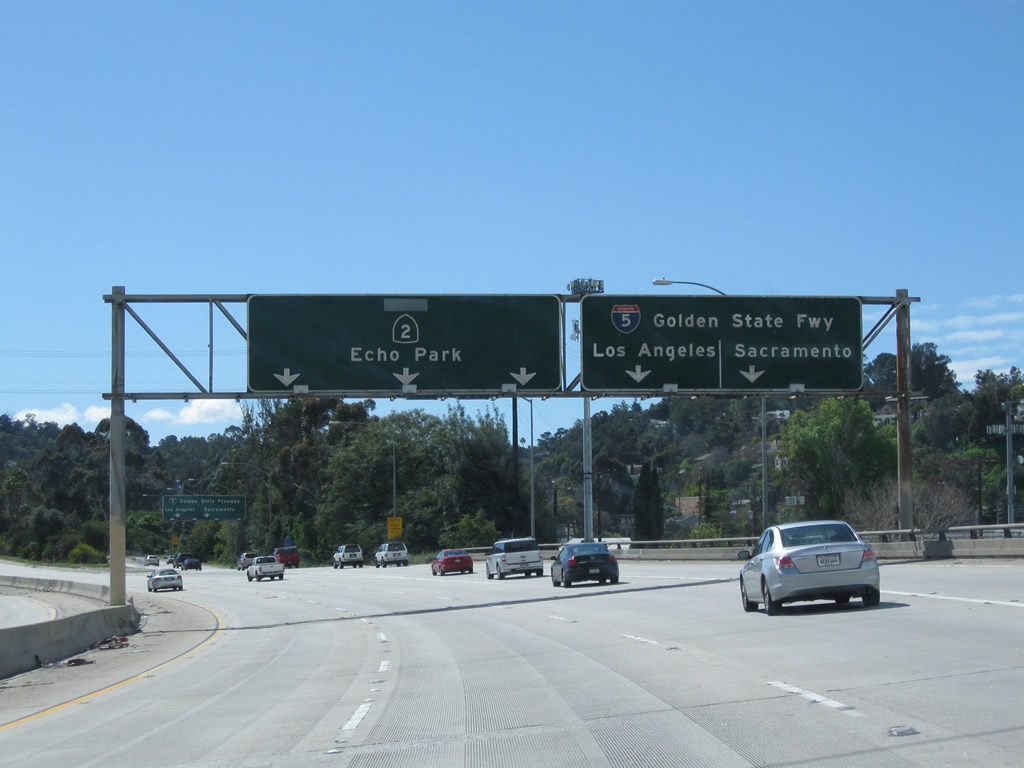 |
The right two lanes of California 2 (Glendale Freeway) south will connect to Interstate 5 (Exit 13A). Interstate 5 travels north to Santa Clarita, Sacramento, Redding, Eugene, Portland, and Seattle before ending at the International Border with Canada. To the south, Interstate 5 travels past downtown Los Angeles (staying closer to East Los Angeles and Boyle Heights), then continues toward Anaheim, Santa Ana, Irvine, Oceanside, and San Diego (ending at the International Border with Mexico). Photo taken 02/26/11. |
 |
As two lanes depart for Exit 13A, Interstate 5 (Golden State Freeway) north/south, the left three lanes continue southwest on California 2 (Glendale Freeway). The freeway will quickly come to an end. Photo taken 02/26/11. |
 |
A California 2 south reassurance shield assembly is posted on the mainline freeway as we pass over Interstate 5. Photo taken 02/26/11. |
 |
The final interchange along California 2 west (south) is with Glendale Boulevard. To continue on California 2 (Glendale Boulevard) west, stay left. To taken Glendale Boulevard north (Exit 12), stay right. Photo taken 02/26/11. |
 |
Westbound (southbound) California 2 meets Exit 12, Glendale Boulevard north. The remaining two lanes connect to California 2 (Glendale Boulevard) southwest to Echo Park, a community of the city of Los Angeles. Photo taken 02/26/11. |
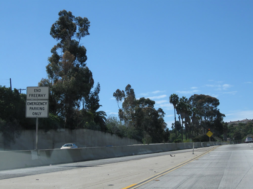 |
An end freeway sign is posted in the median for California 2 south. Photo taken 02/26/11. |
 |
More end freeway signs are posted shortly thereafter. Oddly, no California 2 trailblazers are posted. Photo taken 02/26/11. |
 |
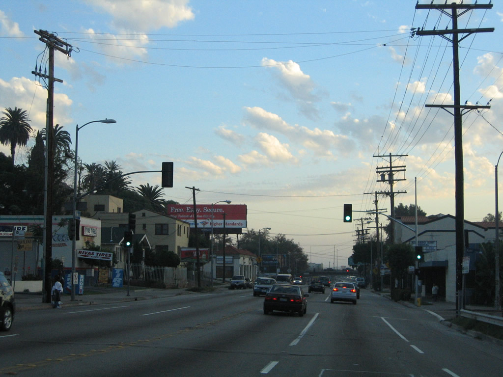
Two lanes carry westbound (southbound) California 2 from the Glendale Freeway onto southbound Glendale Boulevard in Echo Park. Photo taken 02/26/11. |
 |
Westbound (southbound) California 2 curves onto Glendale Boulevard south. The skyscrapers of downtown Los Angeles come into view in the distance. Plans originally called for the California 2 freeway to continue southwest through Echo Park to meet U.S. 101, but this connection looks unlikely to be constructed. And the once-proposed, very controversial Beverly Hills Freeway that would have continued southwest toward Santa Monica is also dead. For now (and probably forever), Glendale Boulevard serves as the southern terminus of the California 2 freeway (excepting the short segment of shared alignment with U.S. 101). The state route, however, continues onto Glendale Boulevard south. Photo taken 02/26/11. |
 |
Continuing southwest on Glendale Boulevard, California 2 meets Aaron Street and officially enters the community of Echo Park. Photo taken 02/26/11. |
 |
At Alvarado Street, California 2 departs from Glendale Boulevard and travels southwest toward its interchange with U.S. 101. From there, the two routes will share alignment briefly, then separate again at the Santa Monica Boulevard interchange. California 2 then follows Santa Monica Boulevard west to Santa Monica (although certain segments have been decommissioned from the state system as Caltrans continues to turn state routes that follow conventional city streets over to the city for operation and maintenance). Photo taken 02/26/11. |
 |
Southbound California 2 (Alvarado Street) meets Montana Street at this traffic signal. A reassurance shield is mounted on the traffic signal pole. Photo taken 09/25/05. |
 |
Four blocks after the intersection with Historic U.S. 66-101/Sunset Boulevard (not shown), southbound California 2 (Alvarado Street) meets Kent Street at this traffic signal. Ahead is the interchange with U.S. 101. Photo taken 09/25/05. |
 |
Westbound (southbound) California 2 approaches U.S. 101 (Hollywood Freeway). The freeway travels south to downtown Los Angeles and northwest to Hollywood. Photo taken 09/25/05. |
 |
To continue west on California 2, turn right to the on-ramp for U.S. 101 (Hollywood Freeway) northwest. The two routes will share alignment until reaching the Santa Monica Boulevard (U.S. 66) interchange. Photo taken 09/25/05. |
 |
California 2 west turns right onto U.S. 101 (Hollywood Freeway) north. Continue straight ahead to connect to U.S. 101 south. Photo taken 09/25/05. |

Page Updated March 16, 2011.
|
About Contact Glossary |
In The News Testimonials Interstate Guide |
Social Media:
 |
|
© 2000-23 AARoads.com | All Rights Reserved | Privacy Policy / Terms of Use
|
||