
Day 5 was probably the shortest with regards to roadding in the Northwest, but nonetheless full with the things that we did see. The main goal of the day was to drive Interstate 5 northward to the International Border and be back in time for dinner. From Burien we pretty much took Interstate 5 up and back, with a couple of side detours thrown in for good measure.
As mentioned previously, Interstate 5 through central Seattle features reversible express lanes and a couple of cut and cover tunnels. The freeway’s interchange with Interstate 90 is stacked, and Interstate 90 itself is double-decked.
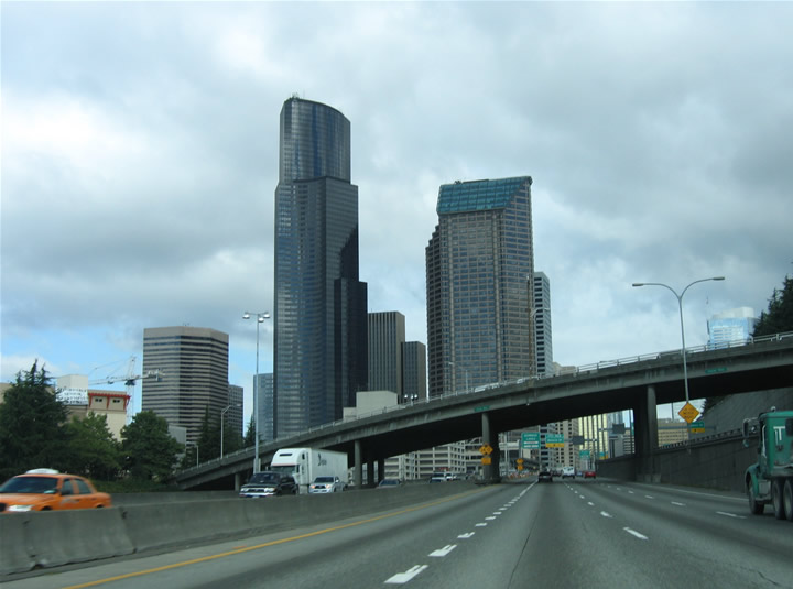
Interstate 5 leaves the interchange with Interstate 90 and approaches downtown Seattle. The express lane split occurs ahead of the cut-and-cover tunnel sections.
North of downtown both Interstate 5 and Washington 99 span Lake Union on high level bridges. The reversible express lanes of Interstate 5 enter the bridge from a tunnel system to the south. It is also within this vicinity that the Mercer Street Merge is located, so traffic is generally heavy during most daylight hours. With Interstate 405 already clinched, we opted to just continue north along Interstate 5 to its northern terminus, and from there to the city of Everett, home of the west end of the western U.S. 2.
U.S. 2 travels initially as a freeway east from Interstate 5 and Walnut Street across the Snohomish to Washington 204 and then southeast toward Washington 9. The highway follows an expressway bypass Snohomish from near Washington 9 south. Construction in the area of the western terminal interchange resulted in a new flyover ramp to Broadway (Exit 192), and will result in the extension of the inner-most HOV-2 lanes northward through Everett.

The first of many U.S. 2 eastbound reassurance markers, posted on the Snohomish River bridge leading east from Interstate 5 and Everett. U.S. 2 ends in northern Michigan, and resumes at Point, New York.
Continuing northward, Interstate 5 carries six lanes of traffic to Mount Vernon (Exit 244 – Old Hwy 99 S), and four lanes from there to the International Border. A truss bridge exists along the southbound lanes over Stillaguamish River between Everett and Mt. Vernon, and along the overall lanes over the Skagit River north of Mt. Vernon.
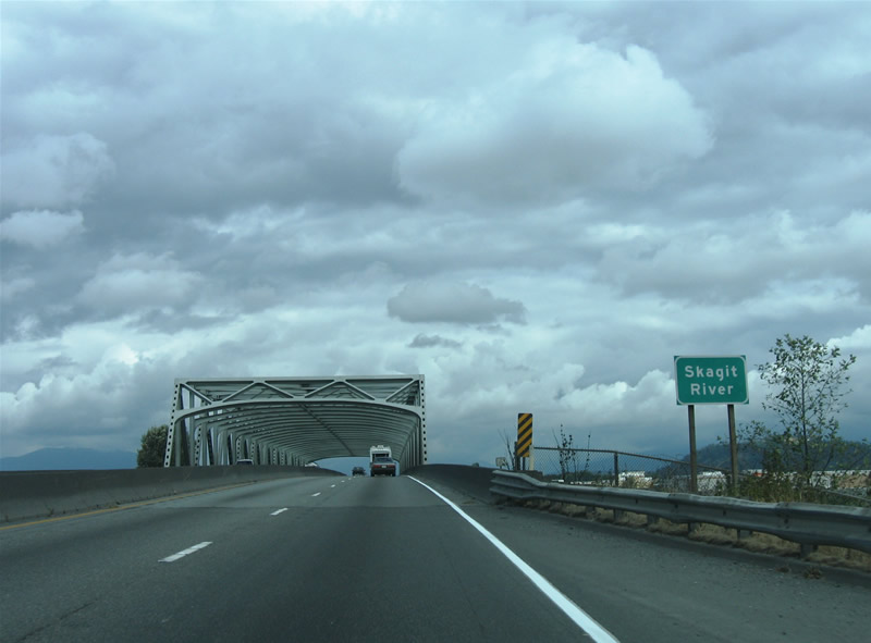
Crossing the Skagit River on Interstate 5 northbound at Mt. Vernon. There are three truss bridges along Interstate 5 between Seattle and the Canadian border.
Once north of Burlington, the freeway loses traffic and changes character into more of a rural freeway. Further north at Lake Samish, Interstate 5 resembles the freeway in central Oregon, with sweeping carriageway splits in the shadow of the Cascade Mountains. The speed limit drops to 60 mph here, but the scenery swings upward in a big way!

Interstate 5 winds through the mountains near Lake Samish.
At Exit 252 Interstate 5 enters the city of Bellingham area. The highway changes its cosmetics again, switching to more of an urban freeway with narrow shoulders and a tight right-of-way. The 60 mph speed limit remains in place as well, with a barrage of on and off-ramps over a short period of time, and a narrow truss bridge over the Nooksack River.

Interstate 5 southbound at the Exit 256 off-ramp north of downtown Bellingham.
From Bellingham northward, Interstate 5 travels along a forested plain to the town of Blaine and the British Columbia line. Traffic pretty much consists of motorists bound to and from Vancouver, Washington, but with that stated, it was pretty light.
Interests to Vancouver are provided with two ports of entry at Blaine. The main port is that of Interstate 5, which transitions into British Columbia 99 (numbered from its previous connection with U.S. 99). Commercial vehicles however are relegated to the port of entry via Washington 543 (13th Street), about 8/10ths of a mile to the east. The segregation allows the Interstate 5 border crossing to function more smoothly.
Of interest at the north end of Interstate 5 is Peace Arch State Park, a green space area encompassing lands along the International Border, Semiahmoo Bay, and the Interstate 5 right-of-way. There visitors can park and walk across the border legally while taking in the beautiful landscaping, the Peace Arch itself, and at the time of our visit, art sculptures that were on exhibit. The park was built as a tribute to the long-lasting peace between the United States and Canada and as an acknowledgment of the long unfortified border between the two countries.
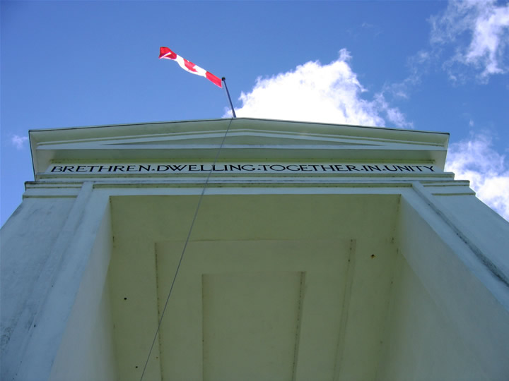
Looking up at the Peach Arch from British Columbian sol. You can literally walk into Canada between the travel lanes of Interstate 5.
On the way back south we took a short side trip along Washington 532 to Stanwood and Island County. How that area resembles the Lake Champlain Region!
South from there, we drove Interstate 5 south to the West Seattle Bridge and Washington 99 again through downtown, including another walk along the waterfront (Alaskan Way) for a bit too. To make it back for dinner, we headed back to Burien via Washington 99, Washington 599, and Interstate 5, noting that the “mainline” of Washington 99 at the split with Washington 509 is misleading and difficult to follow and also that Washington 99 follows an expressway from the partition to the split with Washington 599, and not a freeway as some maps suggest.
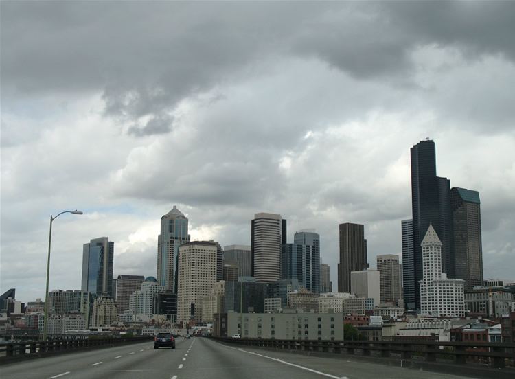
The view of the downtown Seattle skyline from Washington is virtually unobstructed and extremely impressive! Pictured also in this scene is the ramp stub for the unconstructed on-ramp from Interstate 90 west.
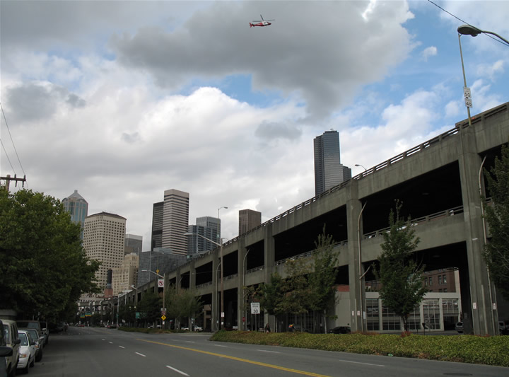
Looking northward at the Alaskan Way viaduct (Washington 99) from the parallel surface boulevard. You can get an idea why so many want this highway torn down, and why they hoped the 2001 earthquake would get the job done.
Interesting tidbit about the Skagit River Bridge – it currently is being rebuilt after being partially destroyed a few weeks ago.