
Interstate 184 - Boise Connector
Interstate 184, the Boise Connector, travels 3.62 miles from I-84 into the city center of Boise, joining the state capitol with the suburbs. The Boise West Connector opened in December 1968 from Interstate 80N, while I-80N (Boise Bypass) was dedicated in 1969 between Maple Grove Road and Isaacs Canyon (Idaho Statesman, 1999). The freeway was designated I-180, Interstate 180N, and Business Loop I-84 in its history.
The easternmost extent of the Boise Connector, including the bridge across the Boise River, opened to traffic in August 1992. A two-stage project between February 15, 1999 and September 6, 2004 reconstructed the "the Flying Wye" joining I-84/184, which was a two-level directional interchange with left exits built in 1968. The replacement was a three-level exchange with new flyovers and all movements from the right. The $48.2 million first stage included construction of the three-lane flyover from I-184 west to I-84 east and the expansion of the Boise Connector to six lanes. The second phase of the overall $86 million road work included the addition of separate Franklin Street off-ramps for Interstate 184 east independent of the freeway mainline, eliminating weaving traffic (Idaho Statesman, 1999, 2001, 2004)
Speed limits on the Boise Connector were increased from 55 miles per hour to 60 miles per hour on October 30, 2012 (Idaho Statesman, 2012).

The eastbound beginning of Interstate 184 departs from I-84 east at Left Exit 49. Exit 1 A follows for Franklin Road at a commercial district anchored by Boise Towne Square mall.
08/09/16

Exit 1 A to Franklin Road departs from both entrance ramps connecting I-84 with I-184 east within the "Flying Wye". This change was made during 2004 reconstruction rebuilding the directional T interchange at I-84/184.
08/09/16

The first confirming marker for Interstate 184 stands within the folded diamond interchange (Exit 1 A) at Franklin Road.
08/09/16

A second reassurance marker for Interstate 184 east precedes the entrance ramp from Franklin Road. Franklin Road travels west to ID 55 (Eagle Road) and the community of Beatty and east to the Morris Hill and Central Bench neighborhoods in south Boise.
08/09/16

Interstate 184 spans Franklin Road and the Boise Valley Railroad across a viaduct beyond this confirming marker. The Boise Mountains rise along the northern horizon.
08/09/16

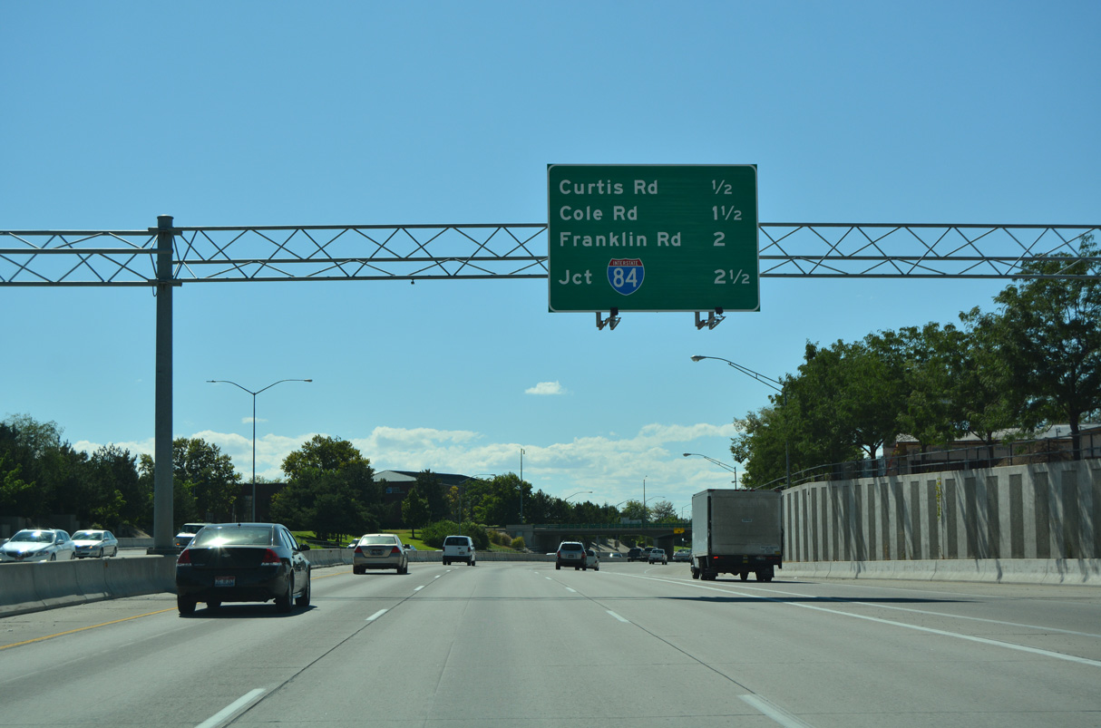
Interstate 184 (Boise Connector) advances northeast one mile to a diamond interchange (Exit 2) with Curtis Road. Curtis Road meets I-184 south of Fairview Avenue and north of St. Alphonsus Regional Medical Center.
08/09/16

Emerald Street passes over Interstate 184 east a half mile ahead of Exit 2. A four lane boulevard, Curtis Road leads south to Morris Hill and north to Winstead Park.
08/09/16

North of parallel Fairview Avenue, Curtis Road crosses Settlers Canal into Garden City where it meets U.S. 20/26 (Chinden Boulevard). Veterans Memorial Parkway continues the arterial northeast to Veterans Memorial State Park and State Street.
08/09/16

A flyover ramp directly links Fairview Avenue eastbound with Interstate 184 beyond Curtis Road.
08/09/16

An auxiliary lane opens from the Fairview Avenue entrance ramp to Exit 3 for the continuation of Fairview Avenue extending east from Orchard Street to Chinden Boulevard (U.S. 20/26) and Downtown Boise.
08/09/16

The pull-through sign for Interstate 184 previously posted at the Orchard Street overpass was replaced by 2011 with a brown guide sign referencing Bogus Basin Recreation Area for River Street.
08/31/06

The unnumbered exit for River Street south at Americana Boulevard departs in one mile from U.S. 20/26 (Boise Connector) beyond the Boise River.
08/09/16

Exit 3 is a slip ramp onto parallel Fairview Avenue east ahead of the Boise River. Fairview Avenue parallels U.S. 20/26 to the north through Downtown Boise.
08/09/16

A final pull-through panel for Interstate 184 was posted at Exit 3 until 2011. River Street angles southeast from the Boise Connector to Julia Davis Park along the Boise River.
08/31/06

U.S. 20/26 overtake the Boise Connector from I-184 east at a wye interchange. The Boise Connector continues east across a viaduct over the Boise River into West Downtown. The freeway ends at 13th Street.
08/09/16

A slip ramp joins Main Street with Interstate 184 (Boise Connector) westbound ahead of Fairview Avenue at Orchard Street.
08/09/16
A diamond interchange joins I-184 with Curtis Road at Exit 2. I-184 curves southwest 2.5 miles to Interstate 84.
08/09/16

Exit 2 leaves I- 184 west for Curtis Road just south of parallel Fairview Avenue. Curtis Road is a four lane boulevard leading north to U.S. 20/26 (Chinden Boulevard) in Garden City and south to Morris Hill and Hillcrest. Fairview Avenue extends through the Winstead Park and West Valley communities of west Boise.
08/09/16

The lone confirming marker for Interstate 184 west stands along the Boise Connector beyond the entrance ramp from Curtis Road.
08/09/16
08/31/06

Exit 1 B to Cole Road departs from I-184 west next in a half mile. A folded diamond interchange with Franklin Road follows at Exit 1 A.
08/09/16

Exit 1 B is a lone off-ramp from I-184 west to Cole Road at Boise Towne Square. Cole Road heads south to I-84/U.S. 30 at Exit 50 and Winstead Park.
08/09/16

Franklin Road is commercial arterial running through west Boise into the city of Meridian.
08/09/16

The entrance ramp from Franklin Road ties into the westbound exit for I-84/U.S. 30 to Nampa and Ontario, Oregon. The reconstruction of the directional T interchange joining I-84/184 in 2004 eliminated weaving traffic between Franklin Road and I-84.
08/09/16

Exit 0 connects I-184 with I-84/U.S. 30 west into Meridian. Nampa is 15 miles to the west.
08/09/16

I-84/U.S. 30 angle southeast from I-184 to Boise Airport (BOI) en route to Mountain Home. The previous control city for I-84 east was Twin Falls.
08/09/16

The exchange joining I-84/184 is nicknamed the "Flying Wye". This view looks east at I-84/U.S. 30 toward Cole Road.
08/09/16
References:
Rebuilding the WYE interchange. (1999, February 7). Idaho Statesman.
Phase 2 will fix danger spots, add amenities. (2001, November 25). Idaho Statesman.
Speeds will return to normal near Wye. (2004, September 5). Idaho Statesman.
Speed limit to increase on Boise Connector. (2012, October 27). Idaho Statesman.
Photo Credits:
- ABRoads: 08/09/16
- AARoads: 08/31/06
Connect with:
Page Updated Friday April 03, 2026.