
Minnesota
Sitemap to all pages covering the state of Minnesota. Photo contributions by Alex Nitzman, Andy Field, Brent Ivy and Chris Kalina.
Interstates

 Interstate 90
300 photos
Business Routes
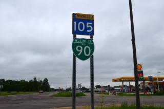
 Business Loop I-90 - Austin
2 photos
State Routes

State Highway 610
Informative Guide
About the Minnesota County State-Aid Highway (CSAH) System
Approximately 30,600 miles of county roads throughout the North Star State fall under the County State-Aid Highway system. These roads are built and maintained by the counties, and are funded by the County State-Aid Highway Fund. Any reference to County State-Aid Highways on Minnesota highway guides will be abbreviated CSAH.
Population
| State Population | |||||
|---|---|---|---|---|---|
| 5,706,494 | |||||
| Metropolitan Populations | |||||
| Minneapolis-St. Paul-Bloomington | 3,690,261 | Duluth, MN-WI | 291,638 | Fargo, ND-MN | 249,843 |
| Rochester | 226,329 | St. Cloud | 199,671 | La Crosse-Onalaska, WI-MN | 139,627 |
| Grand Forks, ND-MN | 104,362 | Mankato | 103,566 | Brainerd | 96,189 |
| Top County Populations | |||||
| Hennepin | 1,281,565 | Ramsey | 552,352 | Dakota | 439,882 |
| Anoka | 363,887 | Washington | 267,568 | St. Louis | 200,231 |
| Olmsted | 162,847 | Stearns | 158,292 | Scott | 150,928 |
| Top City Populations | |||||
| Minneapolis | 433,111 | St. Paul | 306,717 | Rochester | 119,862 |
| Duluth | 85,773 | Bloomington | 84,583 | Plymouth | 79,635 |
| Brooklyn Park | 79,574 | Woodbury | 74,255 | Maple Grove | 72,881 |
| Sources: 2020 U.S. Census Data (metro populations and counties), 2020 U.S. Census Estimate (cities) | |||||
About Minnesota
- Capital:
 St. Paul
 - Nickname: The North Star State, Land of 10,000 Lakes, and Gopher State
- Area: 79,626.74 square miles (land), 14th largest
- Statehood: 32nd state; admitted May 11, 1858
- State Tree: Red Pine
- Highest Point: Eagle Mountain (Superior National Forest), 2,301 Feet above Sea Level
- Total Interstate Mileage: 952.88 miles
Last updated: Wednesday December 29, 2021