

California 111 South - Cathedral City to Indio
| California 111 south | |
|---|---|
 |
In Palm Desert, southeast-bound California 111 meets California 74 at this traffic signal. Turn right for California 74 east up Seven Level Hill to Anza, Mountain Center, Hemet, and Temecula. Turn left for Monterey Avenue north to Interstate 10. The city of Palm Desert had a population was 48,445 as of the 2010 Census and was incorporated as a city on November 26, 1973. All of California 111 within the city limits of Palm Desert was relinquished by the state of California and is now maintained (as of 2008) by the city. Photo taken 06/07/08. |
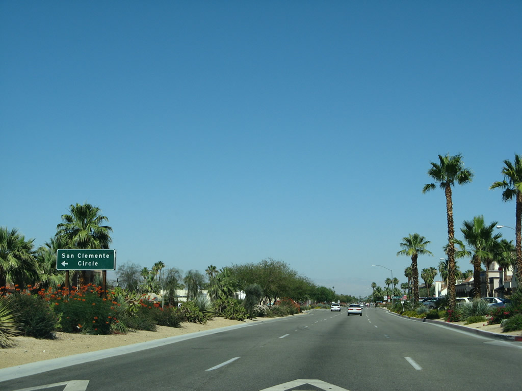 |
Leaving the California 74 and Monterey Avenue intersection, southbound California 111 next approaches San Clemente Circle. Three lanes travel southeast, with a median barrier separating the two directions of traffic and another barrier separating the main lanes from roadside business. Photo taken 06/07/08. |
 |
Southbound California 111 meets Lupine Lane. Photo taken 06/07/08. |
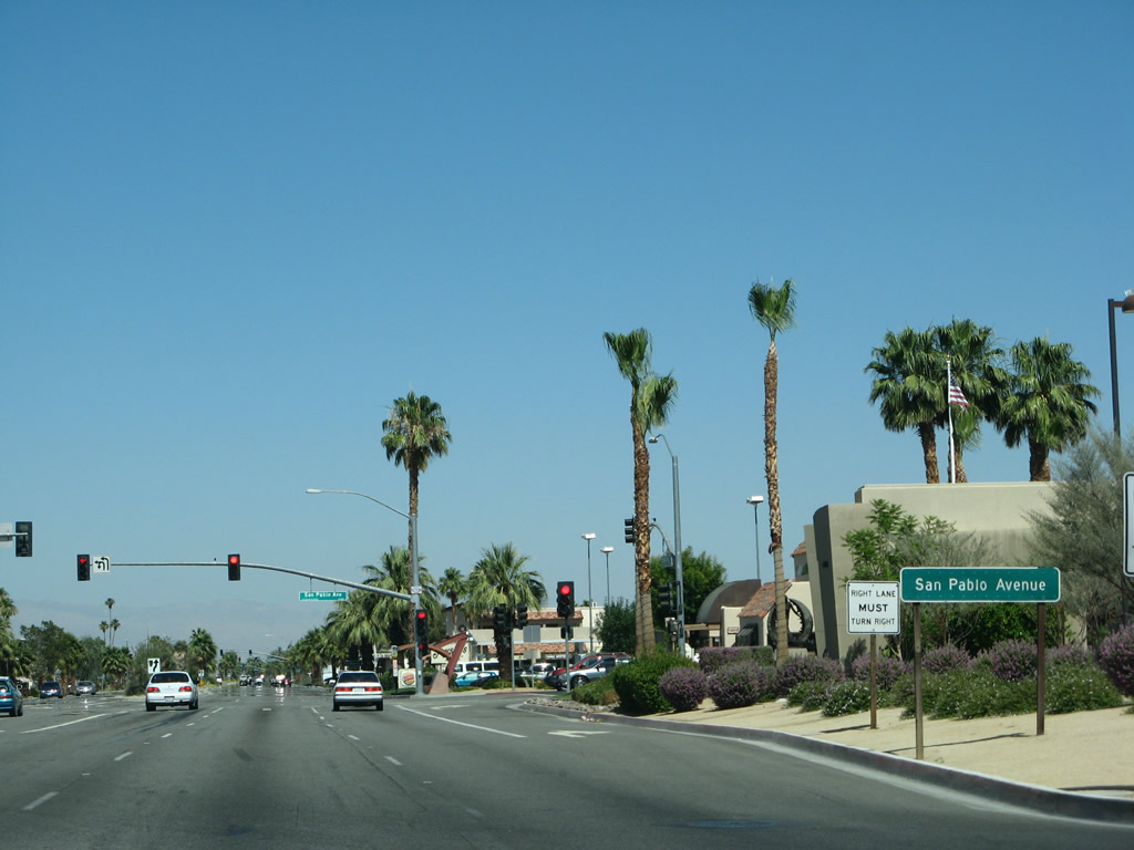 |
The next traffic signal along southbound California 111 is with San Pablo Avenue (traffic signal #62). Turn left here to Palm Desert's civic center and park. Photo taken 06/07/08. |
 |
Landscaping and a frontage road help separate the main lanes from roadside business along California 111 in Palm Desert between San Pablo Avenue and San Luis Rey Avenue. Photo taken 06/07/08. |
 |
The next traffic signal along southbound California 111 is with San Luis Rey Avenue (traffic signal #63). Photo taken 06/07/08. |
 |
Southbound California 111 approaches Portola Avenue (traffic signal #64). Photo taken 06/07/08. |
 |
Occasional access points to the frontage road network warrant a reduced speed. Photo taken 06/07/08. |
 |
California 111 meets El Paseo at this traffic signal (#65). Photo taken 06/07/08. |
 |
The next traffic signal along southbound California 111 is with Deep Canyon Road (traffic signal #66). Photo taken 06/07/08. |
 |
Traffic increases a bit as southbound California 111 approaches Hospitality Row (traffic signal #67), which serves hotels on either side of the highway. Photo taken 06/07/08. |
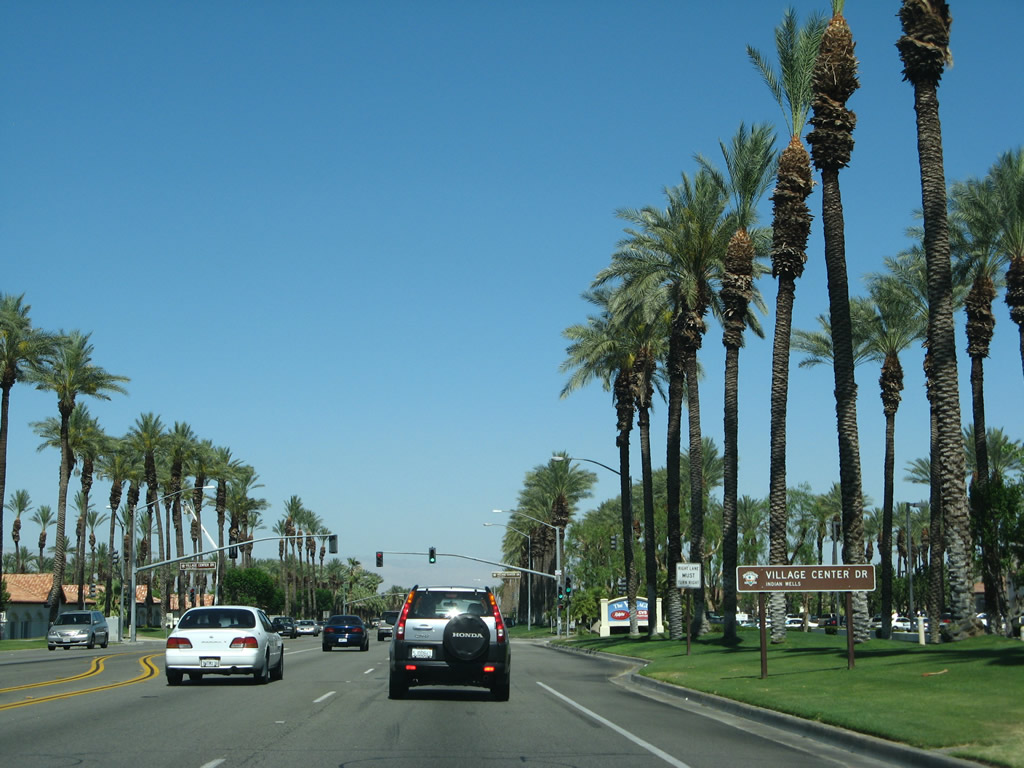 |
After the Hospitality Row intersection, California 111 leaves Palm Desert and enters the city of Indian Wells. Situated in the Coachella Valley, Indian Wells had a population of 4,958 as of the 2010 Census, sits at an elevation of 89 feet, and was incorporated on July 14, 1967. All of California 111 within the city limits of Indian Wells was relinquished by the state of California and is now maintained (as of 2008) by the city. The next traffic signal is with Village Center Drive (#68). Photo taken 06/07/08. |
 |
Palms are a common decorative feature along California 111 it heads southeast through Indian Wells. The next traffic signal is with Cook Street (#69) north to Interstate 10. Photo taken 06/07/08. |
 |
Traffic signal #69A is with Province Way. The lush, green turf and towering palms belie the fact that we are in one of the driest regions in the country. Photo taken 06/07/08. |
 |
Southeastbound California 111 approaches Desert Horizons Drive and Rancho Palmeras Drive (#70). Photo taken 06/07/08. |
 |
Continuing east, California 111 next approaches El Dorado Drive (#71). Note that California 111 has narrowed to only four lanes with no center median and no frontage roads... a major difference from its look in Palm Desert (west of here). Photo taken 06/07/08. |
 |
The next traffic signal is with Indian Wells Lane (#72). Photo taken 06/07/08. |
 |
Traffic signal #73 is with Club Drive. Photo taken 06/07/08. |
 |
Turf and palms line California 111. Nearby golf courses help bolster this theme. Photo taken 06/07/08. |
 |
Southeastbound California 111 next meets Miles Avenue east and Manitou Drive south (#74). Photo taken 06/07/08. |
 |
California 111 swings a bit toward the southeast, then will curve east again. Photo taken 06/07/08. |
 |
The next traffic signal is with Mountain Cove Drive (#75). A rocky outcropping comes into view; California 111 will ascend through a highway cut that will signify the border between Indian Wells and La Quinta. Photo taken 06/07/08. |
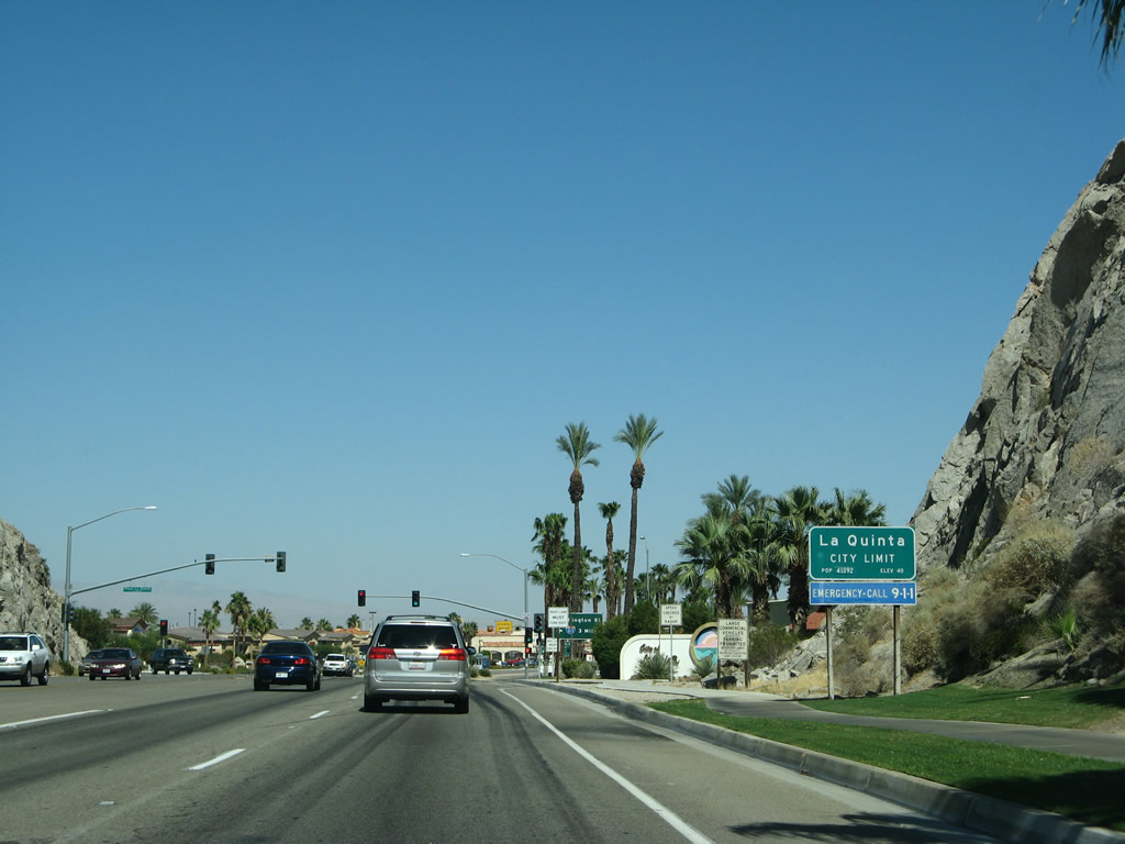 |
At the rock outcropping, California 111 leaves Indian Wells and enters the city of La Quinta ("The Gem of the Desert"), which incorporated on May 1, 1982, and had a population of 37,467 as of the 2010 Census. Like other Coachella Valley communities, La Quinta is known for an abundance of golf courses. Photo taken 06/07/08. |
 |
A more decorative sign for La Quinta is posted soon thereafter, with its motto ("The Gem of the Desert") featured at the bottom of the sign. Photo taken 06/07/08. |
 |
The next signalized intersection is a shopping center entrance (#76) and is followed by the first major intersection along California 111 in La Quinta. The second traffic signal (#77) connects 111 with Washington Street, which travels north to meet Interstate 10 at Exit 137. Photo taken 06/07/08. |
 |
A second guide sign advises that Washington Street travels north to Palm Desert Country Club and Bermuda Dunes. Beyond this sign is the actual signalized intersection with Washington Street (#77). Photo taken 06/07/08. |
 |
California 111 connects with Simon Drive and La Quinta Center Drive (not shown), then approaches this mileage sign for Indio (five miles) and Coachella (eight miles). The desert xeriscape blocks the large shopping area located on the south side of the highway. Photo taken 06/07/08. |
 |
Eastbound California 111 meets Adams Street at this traffic signal (#80). Photo taken 06/07/08. |
 |
The next signalized intersection is with La Quinta Drive (#81). Photo taken 06/07/08. |
 |
Dune Palms Road is the next signalized intersection along Highway 111 east (#82). Photo taken 06/07/08. |
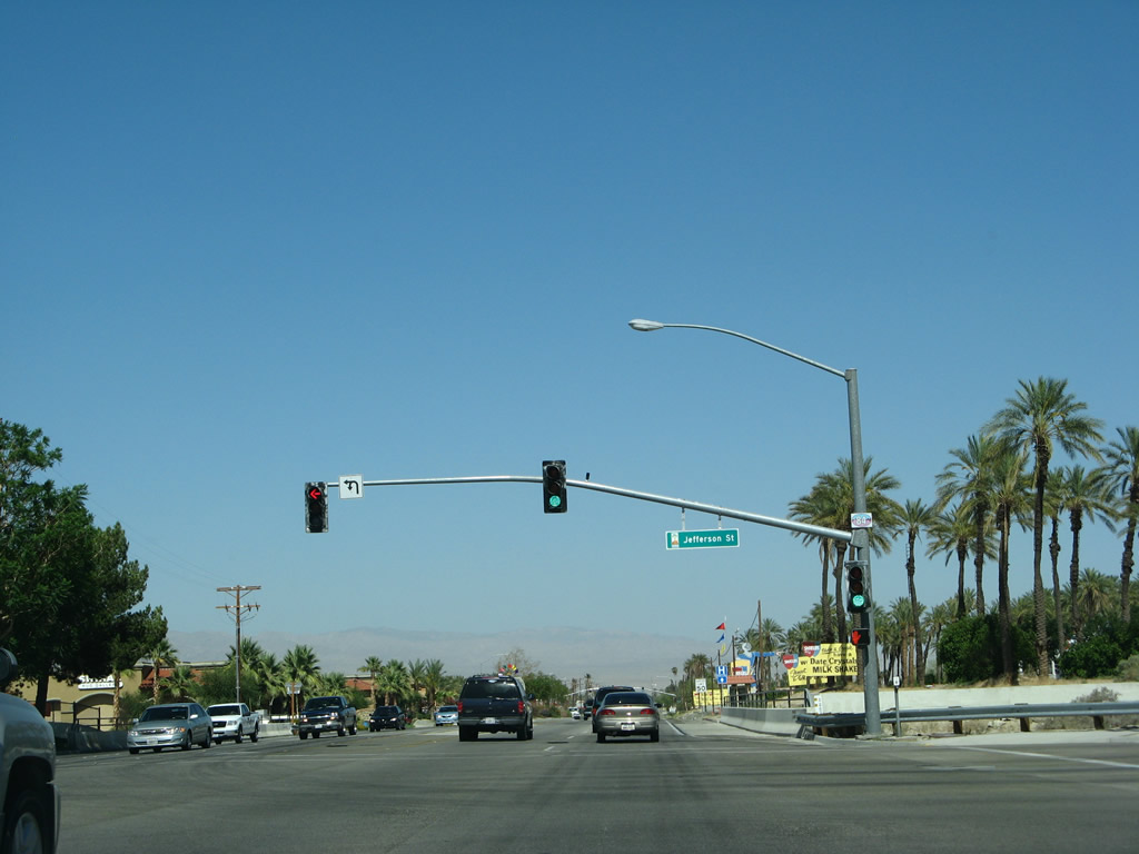 |
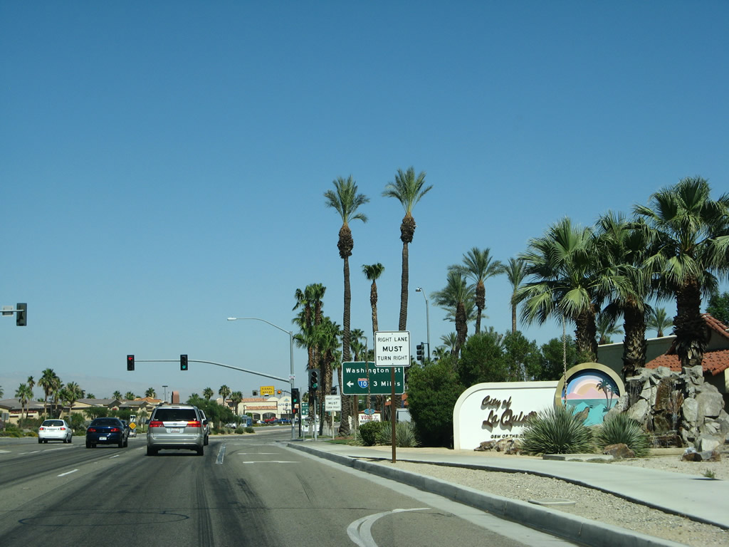
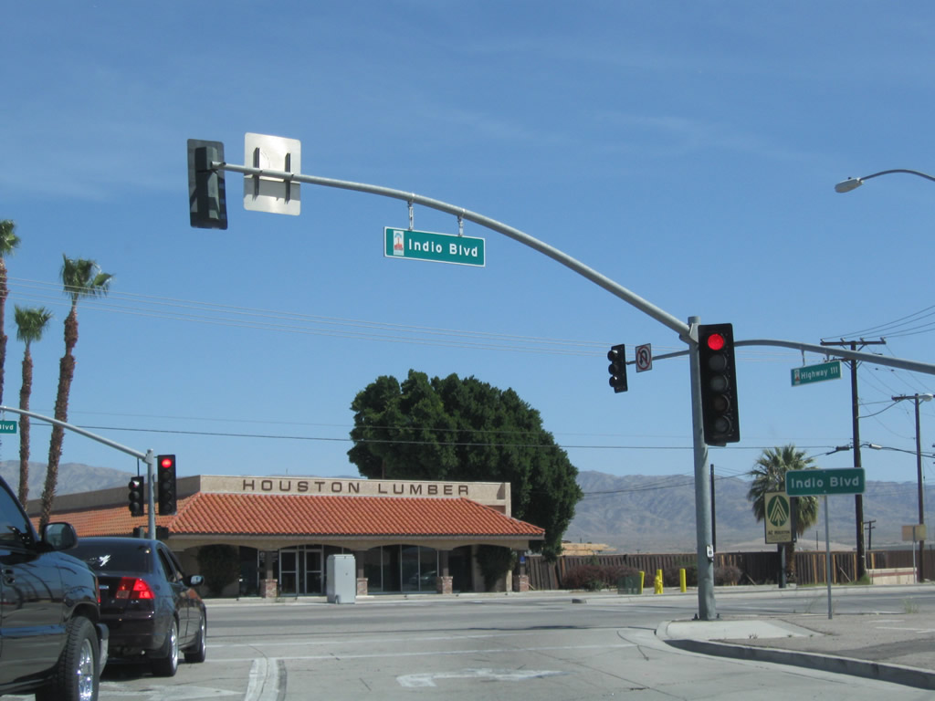
Leaving La Quinta, California 111 enters the city of Indio and approaches the signalized intersection with Jefferson Street. Turn left (north) on Jefferson Street to connect to Interstate 10 Exit 139 and Business Loop I-10 (Indio Boulevard) (Historic U.S. 99). Photo taken 06/07/08. |
 |
Indio, the City of Festivals, had a population of 76,036 as of the 2010 Census and was incorporated as a city on May 16, 1930. The city sits at the historic crossroads of where U.S. 60-70 and U.S. 99 separated and is also the halfway point along the Union Pacific (Southern Pacific) Railroad between Los Angeles and Yuma. Photo taken 06/07/08. |
 |
California 111 continues east past a signalized intersection (#84A) with a driveway entrance, followed by the intersection with Shields Road (#84B). Photo taken 06/07/08. |
 |
The next two signalized intersections are with Madison Street (#85) and Dr. Carreon Drive (47th Avenue) east and Clinton Street north (#86, shown here). Photo taken 06/07/08. |
 |
More commercial activity becomes noticeable along California 111 as we approach Las Palmas Drive (signalized intersection #87). Photo taken 06/07/08. |
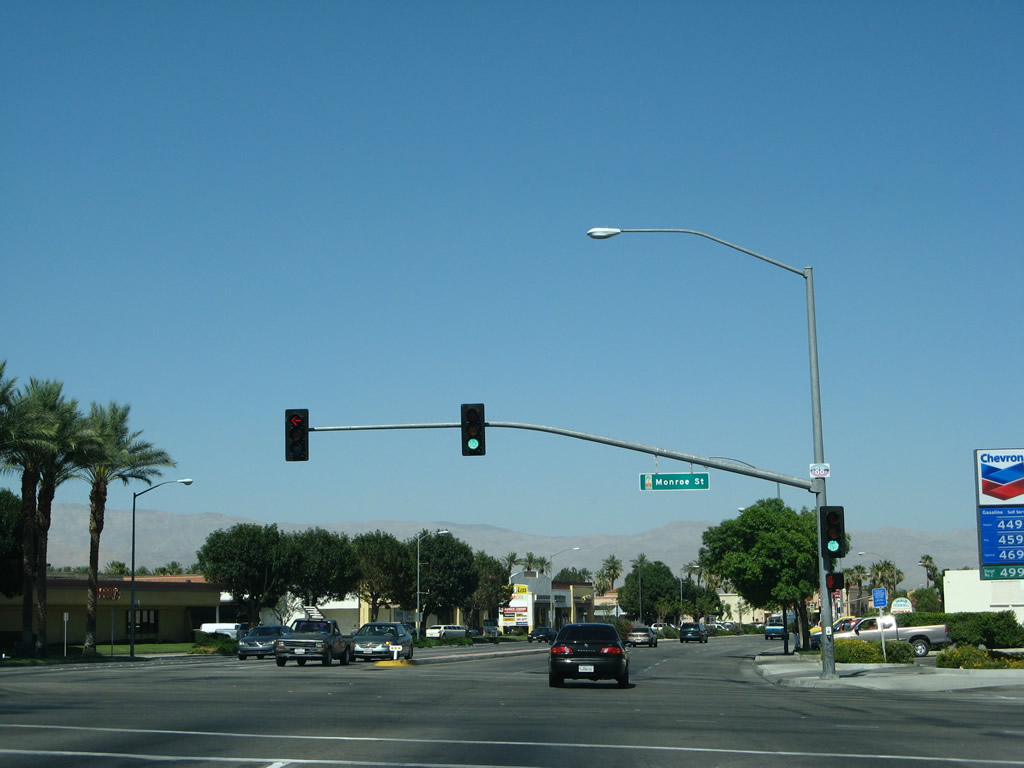 |
Eastbound California 111 meets Monroe Street at this traffic signal (#88). Photo taken 06/07/08. |
 |
California 111 passes by the entrance to the Riverside County Fairgrounds, home of the National Date Festival held annually in February. Photo taken 06/07/08. |
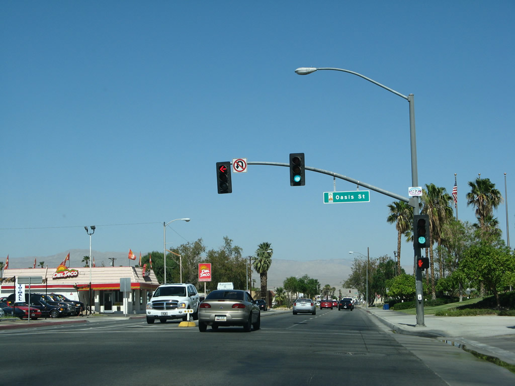 |
Eastbound California 111 meets Oasis Street at this traffic signal (#92). Turn left here to Indio's Old Town district. Photo taken 06/07/08. |
 |
Continuing the line-up of presidentially named streets, California 111 next meets Jackson Street (#93). Turn left here for Interstate 10 Exit 143. Photo taken 06/07/08. |
 |
To Interstate 10, traffic may also use Golf Center Parkway, which links to the freeway at Exit 144. This trailblazer for Interstate 10 was here in 2006 and gone by 2008. Photo taken 05/07/06. |
 |
Also in 2006, a to California 111 trailblazer was posted prior to Golf Center Parkway; this sign was also gone by 2008. Photo taken 05/07/06. |
 |
California 111 ("Highway 111") meets Golf Center Parkway. An Interstate 10 trailblazer is posted here; turn left to connect to the freeway, which travels east to Blythe and Phoenix or west to San Bernardino, Riverside, and Los Angeles. Photo taken 06/07/08. |
 |
Southeastbound California 111 meets Golf Center Parkway at this traffic signal (#94). Turn left here to connect to Interstate 10 Exit 144. Continue ahead to meet Business Loop I-10 and Historic U.S. 60-70-99 (Indio Boulevard). Photo taken 06/07/08. |
 |
 |
After the Golf Center Parkway intersection, southbound former California 111 approaches Indio Boulevard (Business Loop I-10 and Historic U.S. 60-70-99). The signs were replcaed between 2006 and 2008, eliminating the reference to the continuation of California 111 and the beginning of California 86. Photos taken 06/07/08 and 05/07/06. | |
 |
 |
Turn right to follow Business Loop I-10 (Indio Boulevard) and U.S. 60-70-99 southeast toward Coachella and Dillon Road, which reconnects to Interstate 10 east. This intersection marks the (former) northern terminus of California 86. Signs that signified California 86's end as well as the continuation of both California 111 and Business Loop I-10 were removed in 2007 when the routes were relinquished from state control and transferred to city maintenance. California 86 was realigned onto the former California 86S Expressway in late 2012. Photos taken 03/14/09 and 05/07/06. | |
| Business Loop I-10 (Indio Boulevard) east and California 111 south (Historic U.S. 60-70-99 southeast and Former California 86 south) | |
|---|---|
 |
This view looks southeast along Business Loop I-10 (Indio Boulevard) and California 111 in Indio. Photo taken 05/07/06. |
 |
After the Highway 111 and Indio Boulevard intersection in downtown Indio, this Historic U.S. 99 sign is posted along southbound Indio Boulevard. Business Loop I-10 and California 111 are not signed due to the fact that Indio Boulevard was relinquished from the state highway system. Photo taken 06/07/08. |
 |
Southbound California 111 and eastbound Business Loop I-10 meets Van Buren Street at this traffic signal in Indio. Van Buren Street travels south, while Indio Boulevard continues southwest, parallel to the railroad tracks. Photo taken 06/07/08. |
 |
 |
The next signalized intersection along California 111 (Indio Boulevard) and Business Loop I-10 is with Dillon Road. When these pictures were taken, traffic connected to Dillon Road via an at-grade crossing with the railroad. An overpass was built in 2010, and that required all traffic to Dillon Road to turn right at this signal instead. Business Loop I-10 follows Dillon Road east to rejoin Interstate 10 en route to Blythe and Phoenix. Continue straight to follow California 111 southeast to Mecca and California 86 south to Brawley and El Centro. For the first time, California 111 will cease to parallel Interstate 10 and will set out on its own path as it travels south out of the Coachella Valley and toward the Salton Sea and Imperial Valley. This overhead sign used to be the first to mention California 86 south. Even though the sign was changed 2000 and 2008, it was completely gone by 2012. Photos taken 06/07/08 and 11/11/00. |
 |
A second sign for Interstate 10 east to Blythe and Phoenix used to be posted in the median of southbound former California 86-111 and eastbound Business Loop I-10 in Indio. With the new Dillon Road bridge, this median sign was also removed and not replaced. While California 86 and California 111 proceed south into the city of Coachella as Grapefruit Boulevard, and eastbound Business Loop I-10 turns left to return to Interstate 10 via Dillon Road. Old U.S. 60-70-99 follow California 111 south through Coachella, then divide at the point where California 111 and California 86 divide (at the split between Grapefruit Boulevard and Harrison Street in Coachella). U.S. 60-70 follow California 111 southeast to Mecca, then turn east via Box Canyon Road toward Interstate 10 at Chiriaco Summit. U.S. 99 proceeds south along old California 86 and the California 86 expressway toward Desert Shores, Salton City, Brawley, and El Centro. Photo taken 06/07/08. | |
 |
 |
The routes divide at the intersection of Indio Boulevard and Dillon Road (48th Avenue). At the time this picture was taken, construction was underway to build a Dillon Road overpass across Indio Boulevard and the railroad. By Summer 2009, this configuration had changed, with all traffic connecting to Dillon Road turning right and then looping onto the bridge that carries traffic over both Indio Boulevard and the railroad tracks. The 2006 picture shows the intersection before the Dillon Road Grade Separation was built. Note the city limits sign for Coachella in the 2006 picture. Photos taken 03/14/09 and 05/07/06. |

Page Updated March 17, 2013.
|
About Contact Glossary |
In The News Testimonials Interstate Guide |
Social Media:
 |
|
© 2000-23 AARoads.com | All Rights Reserved | Privacy Policy / Terms of Use
|
||