| 32nd Street north |
|
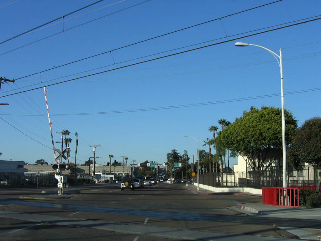
Northbound 32nd Street after the intersection with Harbor Drive, northeast beyond the exit from the Naval Station San Diego (32nd Street Naval Base). Photo taken 12/03/06. |
|
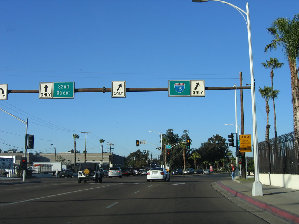
Even though Interstate 15 does not officially begin until the Interstate 8/Interstate 15 interchange, the city of San Diego placed this Interstate 15 shield on the overhead sign prior to the Wabash Boulevard traffic signal. This shield is internally illuminated. Photo taken 12/03/06. |
|
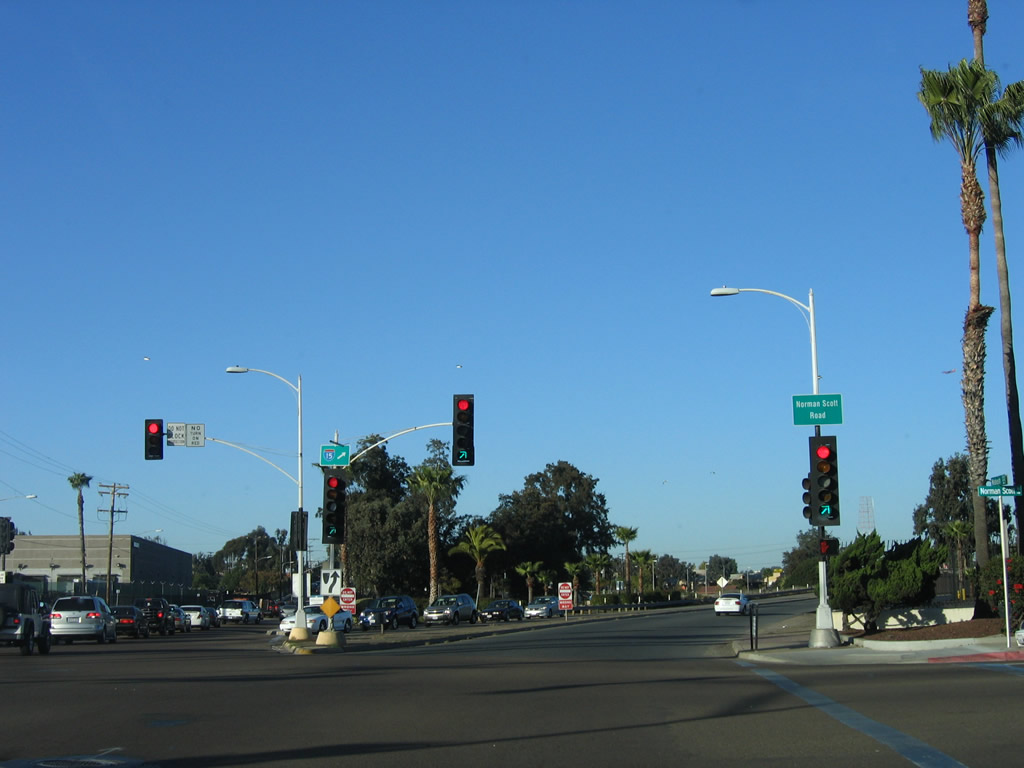
The right two lanes transition from 32nd Street north to Wabash Boulevard north (and a hard right connects to Norman Scott Road to the Naval Station Golf Course). Another smaller Interstate 15 shield is posted on the traffic signal mast arm. Photo taken 12/03/06. |
| Wabash Boulevard north |
|
|
Now traveling north on Wabash Boulevard, this was the first "reassurance" shield for Interstate 15 along northbound Wabash Boulevard (this shield was replaced with another Interstate 15 shield in 1999 and was gone by 2002 ironically about when the 15 freeway through City Heights was completed - see the 2006 photo). In between 32nd Street and Interstate 5, the short freeway connector is known as Wabash Boulevard, and it is maintained by the city of San Diego until the Main Street underpass. Upon reaching Interstate 5, Wabash Boulevard connects directly onto California 15 north. Since both parts are freeway standard, it is easy to see why they are both referred to as part of interstate 15, even though neither is yet part of the Interstate Highway System officially. Photos taken 12/03/06 and 03/08/98. |
|
The naval golf course lines the east side of Wabash Boulevard. The highway rises to pass over Main Street; at that point, state-maintained California 15 begins. Photo taken 12/03/06. |
|
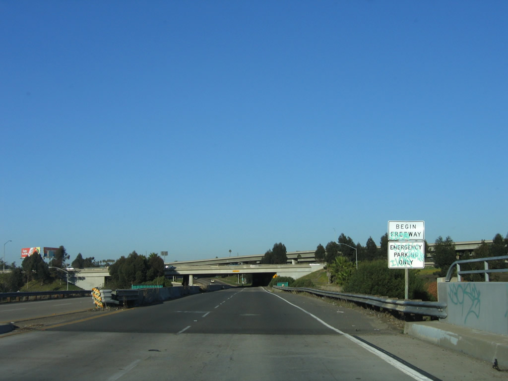
A begin freeway sign is posted upon crossing over Main Street. A second bridge crosses over Chollas Creek. The interchange with Interstate 5 looms ahead; however, there is no access from Wabash Boulevard north to Interstate 5 north or south. Photo taken 12/03/06. |
| California 15/Escondido (Archie Moore Memorial) Freeway north |
|
Northbound California 15 crosses over Chollas Creek and approaches the Interstate 5 interchange. Photo taken 12/03/06. |
|
Traffic from Interstate 5 north merges onto California 15 at this point. The jersey barrier median splits to allow for the southbound ramp split. Photo taken 12/03/06. |
|
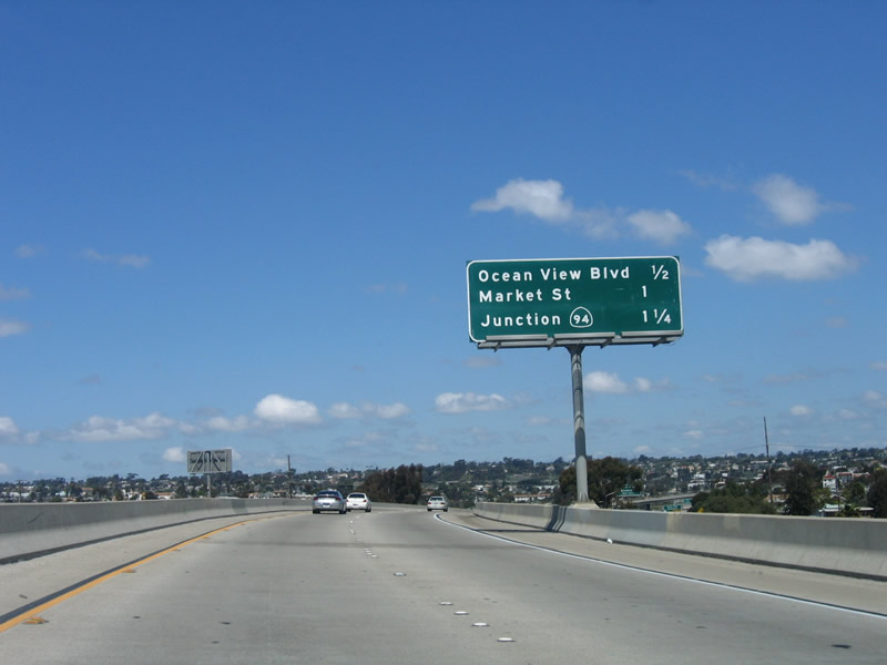
The first California 15 north reassurance shield is posted after the loop on-ramp. An interchange sequence sign provides the distance to the first three exits on California 15 north: Ocean View Boulevard (Exit 1), Market Street (Exit 2A), and California 94/Martin Luther King Freeway (Exits 2B-C). Photo taken 12/03/06. |
|
Ramps connecting California 15 south with Interstate 5 south and Interstate 5 north with California 15 north fly over the nascent freeway. To continue north, skip ahead three photos to the exit only sign for Exit 1, Ocean View Boulevard. Photo taken 12/03/06. |
|
Now looking at the transition ramp from northbound Interstate 5 to northbound California 15 (Escondido Freeway), California 15 begins with two lanes prior to the merge with traffic incoming from 32nd Street and Wabash Avenue. Photo taken 04/09/06. |
|
This mileage sign is located on the transition ramp from northbound Interstate 5 to northbound California 15. The first three exits are Ocean View Boulevard (Exit 1), Market Street (Exit 2A), and California 94/Martin Luther King Freeway (Exits 2B-C). Photo taken 04/09/06. |
|
Still on the transition ramp from Interstate 5 north, this sign is posted prior to Exit 1. Use Exit 1 to Ocean View Boulevard, National Avenue, and Imperial Avenue. Photo taken 04/09/06. |
|
|
Two new lanes join Interstate 5 on the right side; these are incoming from 32nd Street and Wabash Avenue. The right lane becomes exit only for Ocean View Boulevard. This section of California 15 is designated the Archie Moore Freeway, named for a boxer whose house sits on the west side of the freeway. Notice the United Airlines plane in its final approach to Lindbergh Field. Photos taken 04/09/06 and 12/03/06. |
|
Northbound California 15 reaches Exit 1, Ocean View Boulevard to Imperial Avenue. The next exits are for Market Street (unsigned) and California 94. This exit provides access to the Southeastern San Diego neighborhoods. Photo taken 04/09/06. |
|
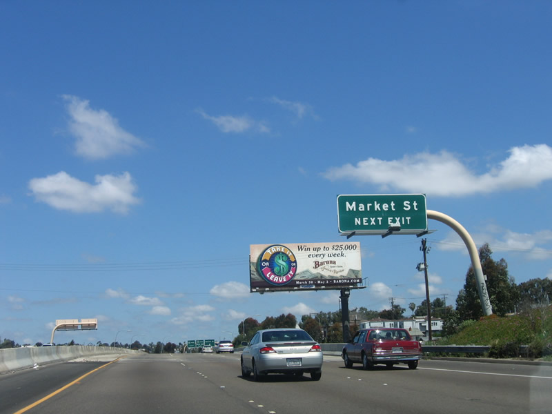
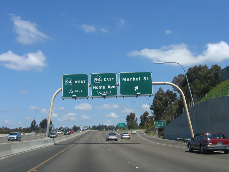
The next exit along northbound California 15 (Escondido Freeway) is Exit 2A, Market Street, three-fourths of a mile. Photo taken 04/09/06. |
|
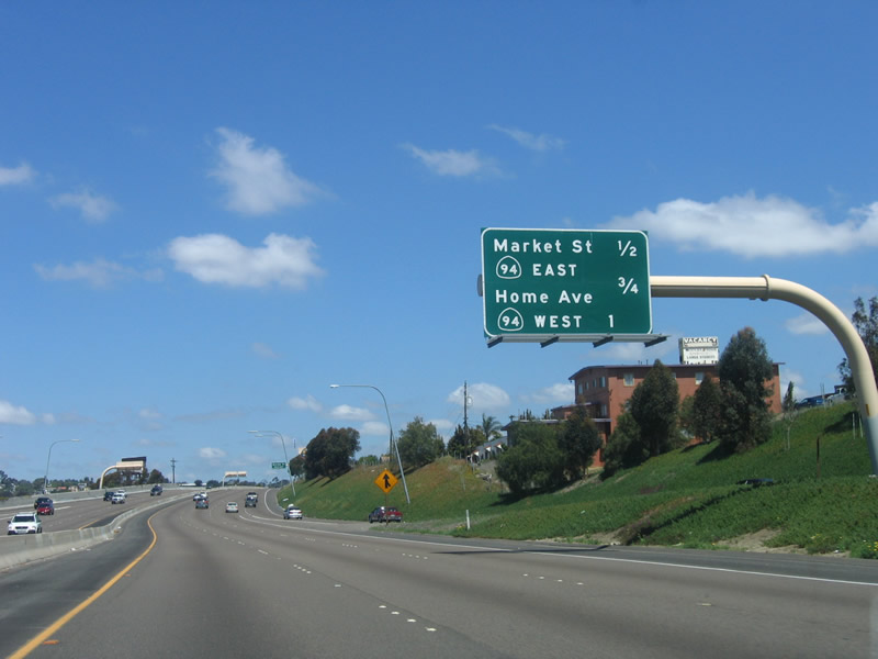
This mileage sign provides the distance to the next three exits along northbound California 15: is Exit 2A, Market Street; Exit 2B, California 94 east and Home Avenue; and Exit 2C, California 94 west to downtown San Diego. Photo taken 04/09/06. |
|
Market Street is a major east-west city street. To the west, it travels toward downtown San Diego, where it becomes part of the street grid. It is the former route of California 94. Between Eleventh Avenue and Harbor Drive, Market Street was also signed as U.S. 80-395 until both routes were decommissioned in the 1970s. Photo taken 04/09/06. |
|
|
Northbound California 15 reaches Exit 2A, Market Street. The next exit is for California 94/Martin Luther King Freeway. Photos taken 04/09/06 and 12/03/06. |
|
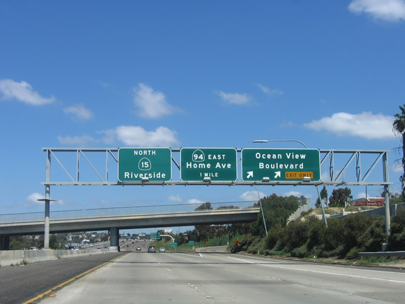
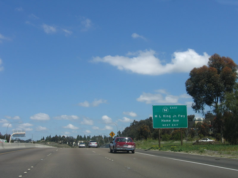
The next exit along northbound California 15 is Exit 2B, eastbound California 94 (Martin Luther King, Jr. Freeway). This reflective sign was placed in 1999 as part of a project to add "Martin Luther King Jr. Freeway" to most signs that have a California 94 shield. (Note that the shield actually carries the state name, which is unusual for a guide sign.) This effort was funded by the city of San Diego, not the state of California. Photo taken 04/09/06. |
|
The junction between California 15 and California 94 (Martin Luther King, Jr. Freeway) comes into view. California 15 stays lower than California 94 as they prepare to interchange. Photo taken 04/09/06. |
|
Northbound California 15 reaches Exit 2B, California 94 (Martin Luther King, Jr. Freeway) east to Lemon Grove and Campo. Notice how the freeway narrows to two through lanes here; this interchange is planned for reconstruction sometime after 2010. The two right signs are reflective, while the Interstate 805 junction sign is button copy non-reflective. Photo taken 04/09/06. |
|
This view of the California 15 and California 94 interchange is afforded from the northbound mainline. In addition to the poor visibility, left exits along California 94 and blind merges mean that this interchange is not Interstate-standard. Therefore, California 15 cannot be designated as Interstate 15 until it is reconstructed with the substandard elements upgraded. Photo taken 04/09/06. |
|
Northbound California 15 reaches Exit 2C, California 94 (Martin Luther King, Jr. Freeway) west. Note how this is almost a sharp right turn onto westbound. This tight loop ramp connects northbound California 15 with westbound California 94. The traffic signal is a ramp meter between the two freeways. Photo taken 12/03/06. |
| California 15 (Escondido Freeway) north |
|
The next exit along northbound California 15 is Exit 3, Interstate 805, one mile. There is no direct access to southbound Interstate 805. Photo taken 04/09/06. |
|
A variable message sign is posted along northbound California 15 between California 94 and Interstate 805. Photo taken 04/09/06. |
|
Northbound California 15 approaches Exit 3, Interstate 805, one-half mile. Interstate 805 leads north toward North Park and central Mission Valley, while California 15 continues north into City Heights and eastern Mission Valley. Photo taken 04/09/06. |
|
California 15 widens out as it approaches Exit 3. The two right lanes exit onto northbound Interstate 805, while the remaining three lanes continue north into City Heights. The overhead sign used to read "Freeway Ends - California 15 North 40th Street." Now it refers to the Interstate 15 control city of Riverside. Photo taken 04/09/06. |
|
Interstate 805 crosses over California 15 prior to the exit ramp to northbound Interstate 805. Photo taken 04/09/06. |
|
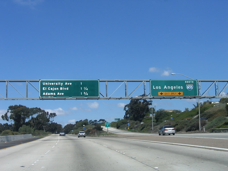
Northbound California 15 reaches Exit 3, Interstate 805. The next three exits are University Avenue, El Cajon Boulevard, and Adams Avenue. The upcoming section of California 15 was constructed in the late 1990s and fully opened to traffic in December 2001. Photo taken 04/09/06. |
|
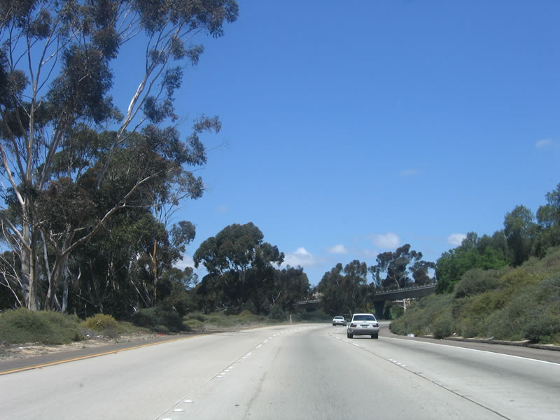
Passing northeast of Interstate 805, California 15 begins to gain some elevation as it winds its way into the City Heights neighborhood of San Diego. Photo taken 04/09/06. |
| California 15 (Escondido Freeway) (40th Street Freeway) north |
|
The next exit along northbound California 15 is Exit 5A, University Avenue, followed by Exit 5B, Business Loop I-8 (El Cajon Boulevard). These reflective signs were installed just prior to the implementation of the new exit numbering system. Photo taken 04/09/06. |
|
|
As traffic merges onto northbound California 15 from Interstate 805, we find a reassurance shield for Interstate 15. Back in 2006, this was a California 15 route marker. At some point in between, the state route shield was replaced by an Interstate shield, one of the few Interstate shields found on this stretch of California 15. Photos taken 07/28/14 and 04/09/06. |
|
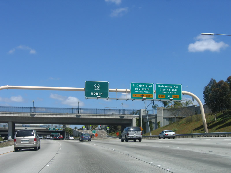
It's not just your eyes; these signs along northbound California 15 are not easy to read due to small fonts. We are approaching Exit 5A-B, University Avenue and El Cajon Boulevard; the two right lanes are exit only, while the left four lanes are for through traffic. The median is wide enough to accommodate rapid transit, most likely in the form of a trolley extension. Photo taken 04/09/06. |
|
Northbound California 15 reaches Exit 5A, University Avenue to the City Heights Transit Plaza. The overpass is for University Avenue. The next exit is Exit 5B, Business Loop I-8 (El Cajon Boulevard) and Historic U.S. 80-395 to the Boulevard Transit Plaza. These signs were installed after the California 15 freeway was completed to advertise the multimodal transportation hub for bus transportation in City Heights. Although California 15 was designed with room for light rail in the median, no funded plans currently exist for installing such a corridor anytime soon. Photo taken 04/09/06. |
|
Northbound California 15 reaches the connecting ramp to Exit 5B, Business Loop I-8 (El Cajon Boulevard, signed as Historic U.S. 80 and U.S. 395) in City Heights. The next exit is for Exit 6A, Adams Avenue. Photo taken 04/09/06. |
|
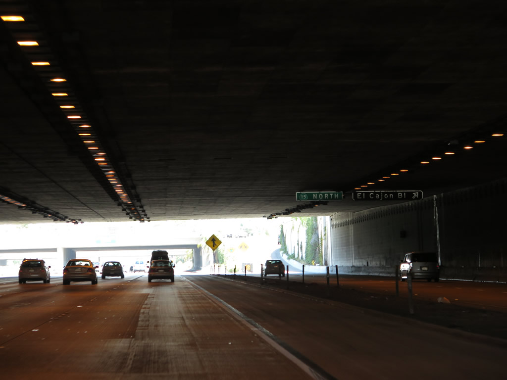
A roadside sign for Exit 5B, El Cajon Boulevard is posted just before the freeway enters a two-block long cut and cover tunnel under Teralta Park. Photo taken 07/28/14. |
|
A low median barrier separates the local lanes that connect northbound California 15 with El Cajon Boulevard and the four left lanes, which continue north toward Mission Valley and Tierrasanta. Traffic merges onto the northbound local lanes from University Avenue. Here, the freeway passes under Teralta Park, which is a cut and cover tunnel that carries California 15 under City Heights for a full city block between Polk Avenue and Orange Avenue. Photo taken 04/09/06. |
|
While in the tunnel segment, northbound California 15 meets Exit 5B, El Cajon Boulevard (Business Loop I-8 and U.S. 80-395). Photo taken 07/28/14. |
|
Now exiting the cut and cover tunnel, California 15 approaches the overpass for El Cajon Boulevard. The local (collector distributor) lanes have a ramp to El Cajon Boulevard, and a lane merges back onto northbound California 15. Photo taken 04/09/06. |
|
The next exit along northbound California 15 is Exit 6A, Adams Avenue, one-half mile. Looking at the depressed freeway, it is hard to imagine that this was once a traffic-choked stretch of 40th Street that featured daily delays between University Avenue and Adams Avenue. Photo taken 04/09/06. |
|
Passing under Meade Avenue (no exit), this sign for Adams Avenue is posted on the overcrossing. Adams Avenue is one of several east-west streets that are named for presidents; most of these streets are clustered in North Park, a community located to the west of California 15. North Park is so named due to its located north and east of Balboa Park, which can be considered San Diego's version of a "Central Park." Photo taken 04/09/06. |
|
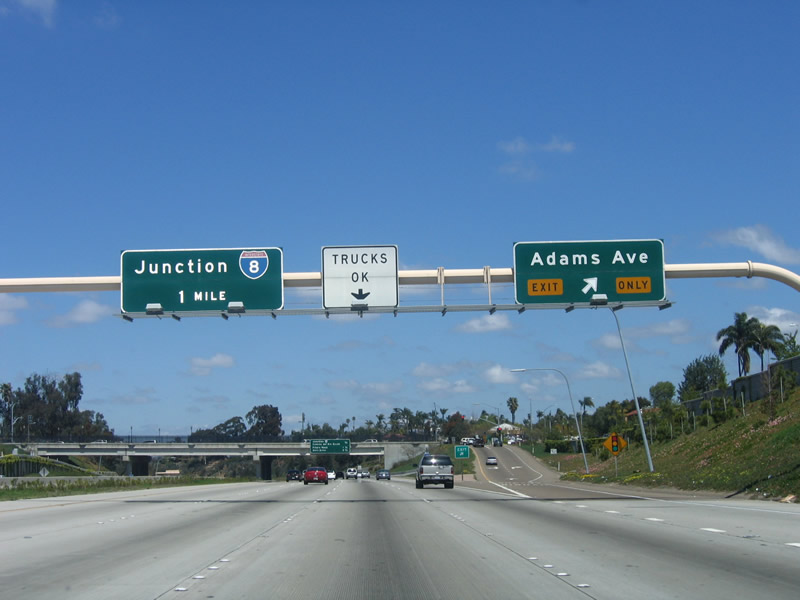
Northbound California 15 reaches Exit 6A, Adams Avenue. Adams Avenue is a locally famous corridor for restaurants, antique stores, used bookstores, and a variety of specialty shops. Twice annually, Adams Avenue is the site of cultural festivals that bring many San Diegans together: the Adams Avenue Street Fair in the fall and the Adams Avenue Roots Festival in the spring. This is the end of the section that opened in 2001; the route between here and Interstate 8 was improved in 2001, but it was a freeway prior to that. Photo taken 04/09/06. |
| California 15 (Escondido Freeway) (Ward Road) north |
|
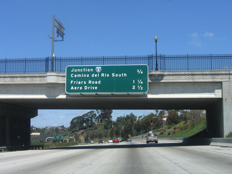
This mileage sign along northbound California 15 provides the distance for the next four exits: Exit 6B, Interstate 8/Camino del Rio South (three-quarters of a mile); Exits 7A-B, Friars Road (East and West); and Exit 8, Aero Drive. This sign is located on the Adams Avenue overpass. Photo taken 04/09/06. |
|
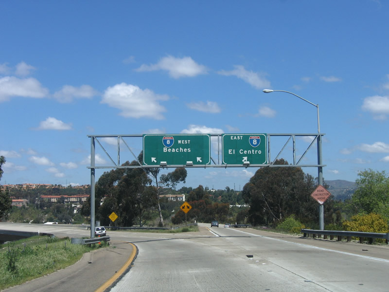
The next exit along northbound California 15 is Exit 6B, Interstate 8, the Mission Valley/Alvarado Freeway. Interstate 8 leads east toward the eastern end of the city of San Diego, as well as the suburbs of La Mesa and El Cajon. Heading west, Interstate 8 enters Mission Valley, then follows the San Diego River until it terminates in Mission Bay Park at Sunset Cliffs Boulevard/Nimitz Boulevard. As noted in this picture, the overhead sign points to California 15 rather than Interstate 15 continuing north of Interstate 8. Since this particular spot is still California 15, this sign is technically correct. There is no end California 15 shield; the next set of overhead signs say "Interstate 15." Photo taken 04/09/06. |
|
This is the third and final northbound California 15 reassurance shield. The freeway descends from City Heights into the Mission Valley community, which follows the San Diego River on an east-west course through the center of San Diego. Photo taken 04/09/06. |
|
Interstate 8 leads east toward San Diego University, La Mesa, Grossmont, and El Cajon before leaving the urban areas via the Cuyamaca and Laguna Mountains of Cleveland National Forest. Heading west, Interstate 8 connects with Interstate 805, California 163, and Interstate 5 before terminating in Mission Bay Park just northeast of Ocean Beach. Photo taken 04/09/06. |
|
Northbound California 15 reaches Exit 6B, Interstate 8 and Camino del Rio South. This is the last northbound reassurance guide signage for California 15. Photo taken 04/09/06. |
|
Now on the transition ramp for Exit 6B, the first exit connects to Camino del Rio South, which is the frontage road for Interstate 8. Continue straight ahead for the connection to Interstate 8 east and west. Photo taken 04/09/06. |
|
After the exit ramp for Camino del Rio South, the ramp further splits into eastbound and westbound Interstate 8. Photo taken 04/09/06. |
|
Qualcomm Stadium, home of the San Diego Chargers (National Football League team), comes into view on the transition ramp from northbound California 15 to westbound Interstate 8. Photo taken 04/09/06. |
|
|
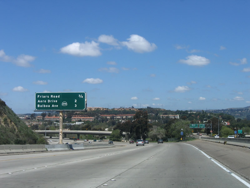
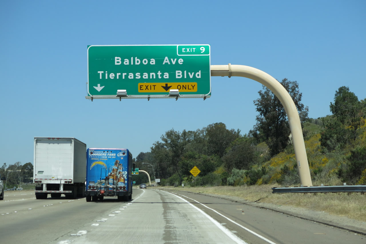
Now back on mainline California 15, this mileage sign provides the distance to the next four exits: Exits 7A-B, Friars Road (East and West); Exit 8, Aero Drive; and Exit 9, Balboa Avenue (former California 274) and Tierrasanta Boulevard. By 2014, this sign had changed to reflect the elimination of California 274. Photos taken 07/28/14 and 04/09/06. |
|
The interchange between California 15 and Interstate 8 comes into view. While Interstate 8 takes the bottom level, California 15/Interstate 15 takes the middle deck. Flyover ramps connect southbound Interstate 15 to eastbound Interstate 8 and northbound California 15 to westbound Interstate 8. Photo taken 04/09/06. |
|
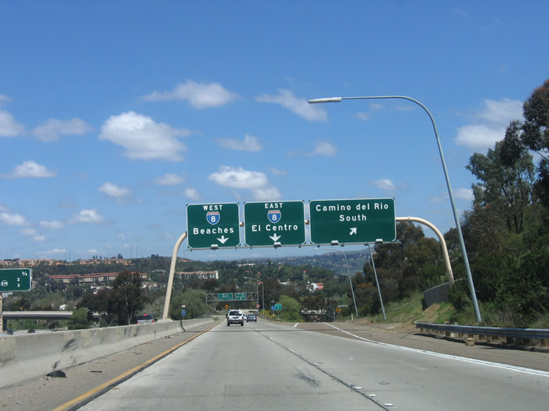
As California 15 crosses over Interstate 8 and the ramp from eastbound Interstate 8 merges onto California 15, the signed state route ends and Interstate 15 begins. Photo taken 04/09/06. |
| Interstate 15 (Escondido Freeway) north |
|
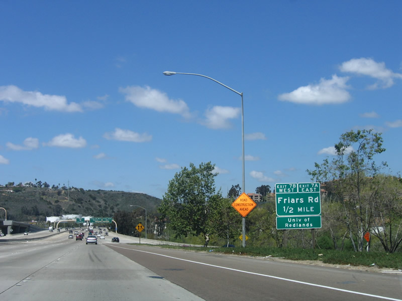
The first exit along northbound Interstate 15 is Exit 7A, Friars Road. This roadside sign attempts to explain that the first right is for Friars Road east (Exit 7A) followed by the second right for Friars Road west (Exit 7B). Photo taken 04/09/06. |
|
This is the first reassurance signage for northbound Interstate 15. The right two lanes exit only to Friars Road (Exits 7A-B). Photo taken 04/09/06. |
|
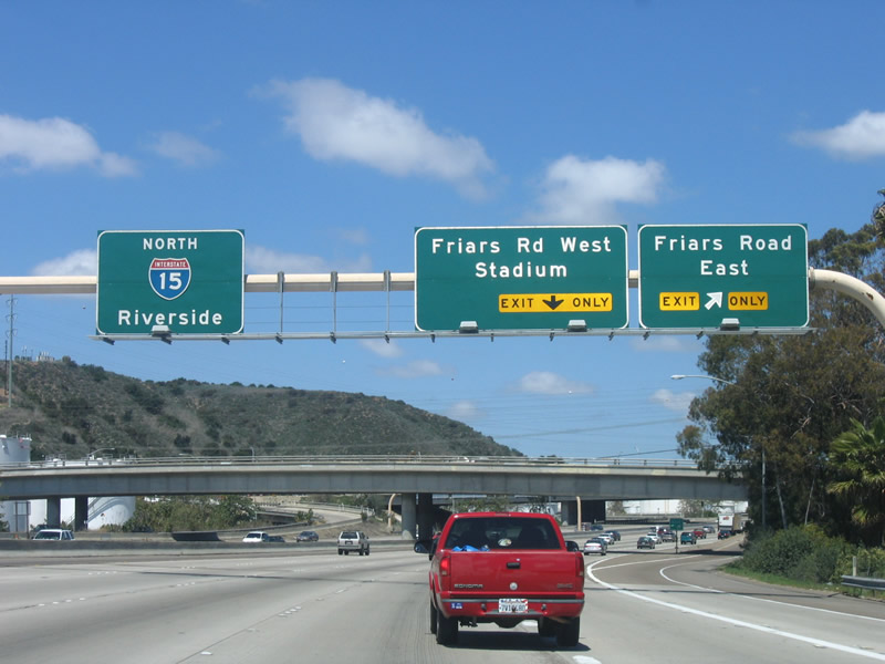
Northbound Interstate 15 reaches Exit 7A, Friars Road east. Use Friars Road east to the San Diego Mission, Mission Gorge, and Mission Trails Regional Park via Mission Gorge Road. Photo taken 04/09/06. |
|
The second ramp in this modified partial cloverleaf interchange serves as the connection to westbound Friars Road via Exit 7B. Use Friars Road west to Qualcomm Stadium, the Mission Valley Library, and a variety of shopping centers (including the Ikea at Fenton Plaza). Photo taken 04/09/06. |
|
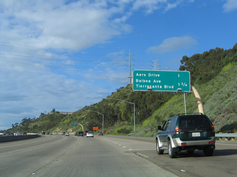
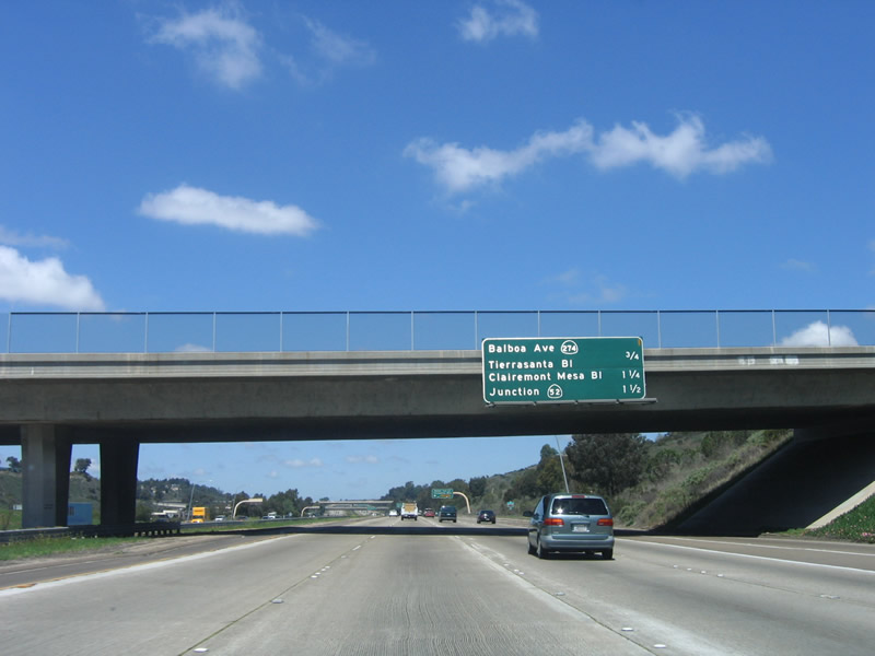
This mileage sign provides the distance to the next three exits along northbound Interstate 15: Exit 8, Aero Drive; Exit 9, former California 274 (Balboa Avenue) west and Tierrasanta Boulevard east; and Exit 10, Clairemont Mesa Boulevard. Photo taken 03/05/05.
|
|
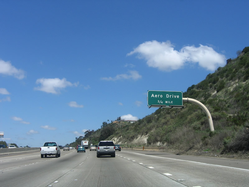
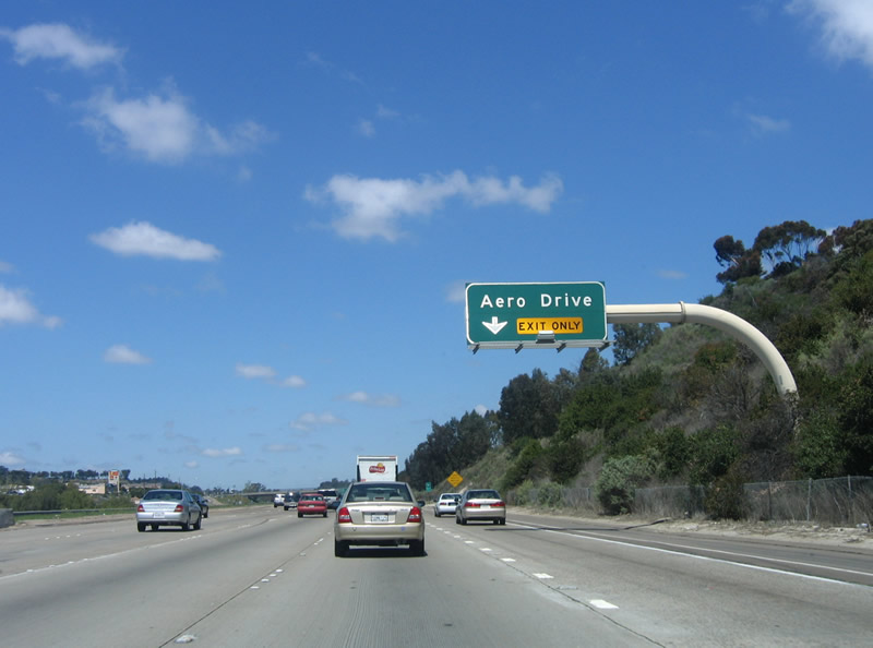
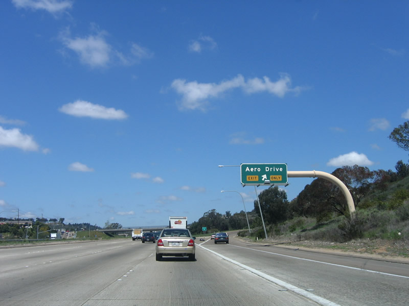
The next exit along northbound Interstate 15 is Exit 8, Aero Drive. The right lane becomes exit only for Aero Drive. Photo taken 04/09/06. |
|
As suggested by its name, Aero Drive provides access to the general aviation Montgomery Field Airport west of Interstate 15. Look to the sky for small planes making their final approach to the airport. It also provides a connection to the Serra Mesa and Kearny Mesa communities to the west as well as Tierrasanta to the east. Photo taken 04/09/06. |
|
Northbound Interstate 15 reaches Exit 8, Aero Drive. The freeway enters an area locally known as Murphy Canyon. The San Diego Chargers practice field is located west of Interstate 15 along Murphy Canyon Road, which is Old California 103. Before Interstate 15 was legislatively extended south of San Bernardino in the 1970s, the sections of today's Interstate 15 generally followed U.S. 395. However, this section of freeway, from Interstate 5 north to California 163, was signed as California 103 until the Interstate was designated and signed. Photo taken 04/09/06. |
|
|
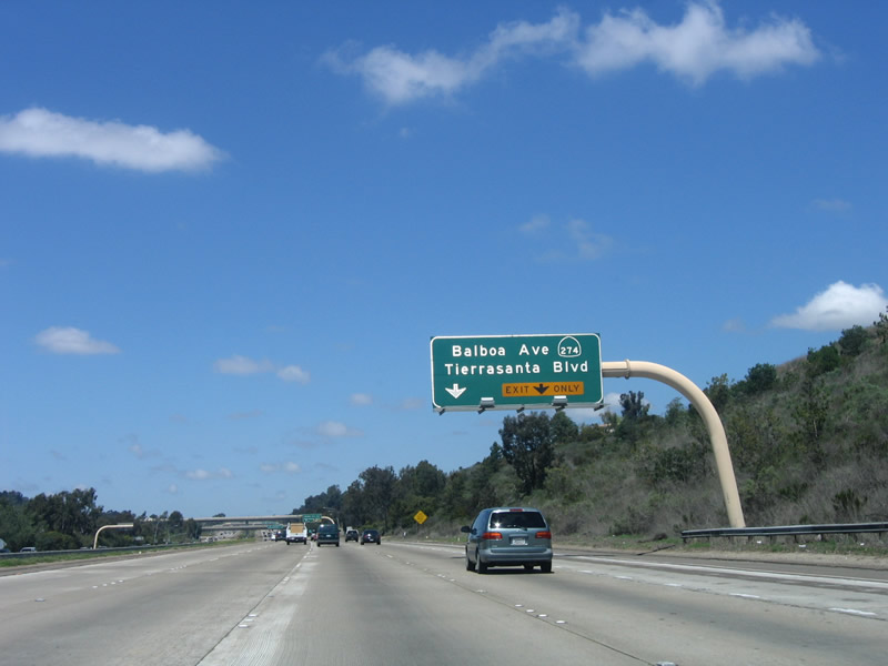
This mileage sign provides the distance to the next three exits on northbound Interstate 15: Exit 9, Balboa Avenue (former California 274) west and Tierrasanta Boulevard east; Exit 10, Clairemont Mesa Boulevard; and Exit 11, California 52 (Soledad Freeway) east to Santee and west to La Jolla. This sign was replaced in December 2012 and no longer contains the California 274 sign. A variable message sign was also placed here to provide travel times. Photos taken 04/19/13 and 04/09/06. |
|
|
The right lane becomes exit only for Exit 9, Balboa Avenue west and Tierrasanta Boulevard east. Even though it was decommissioned in 2001, California 274 remained signed from Interstate 15 until December 2012. Photos taken 04/19/13 and 04/09/06. |
|
|
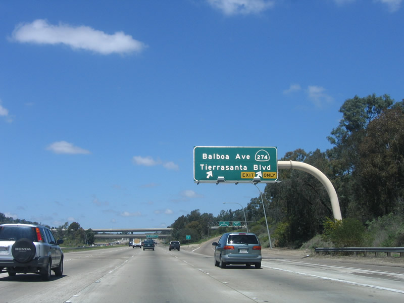
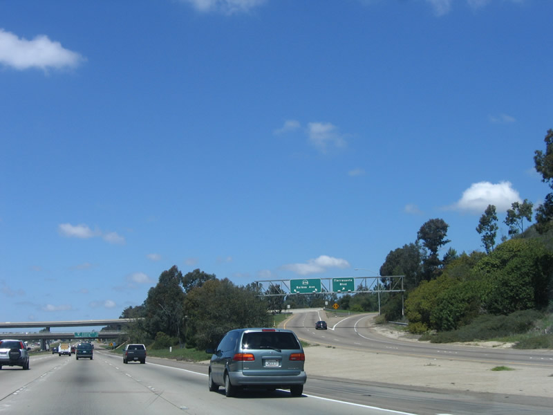
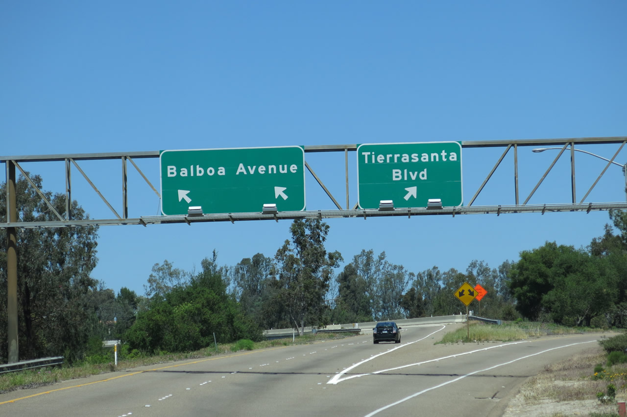
Northbound Interstate 15 reaches Exit 9, Balboa Avenue (former California 274) west and Tierrasanta Boulevard east. California 274 used to travel west along Balboa Avenue through Kearny Mesa and Clairemont to connect with Pacific Beach on the coast; the entire state route was located within the city limits of San Diego. Looking east, Tierrasanta Boulevard (which was never a state highway) travels into the community of Tierrasanta. It ends at a staging area into Mission Trails Regional Park. Due to community opposition, Tierrasanta Boulevard does not connect with Mission Gorge Road, despite traffic planners' efforts to make that connection. Today that land is preserved as part of the regional park. Photos taken 04/19/13 and 04/09/06. |
|
A flyover ramp connects northbound Interstate 15 to Former California 274 (Balboa Avenue) westbound. Photo taken 04/09/06. |
|
Now on the transition ramp, the two-lane exit splits. The left two lanes will fly over the freeway to conect to Balboa Avenue (Former California 274) westbound. The right lane has an optional connection to Tierrasanta Boulevard east. Photo taken 04/19/13. |
|
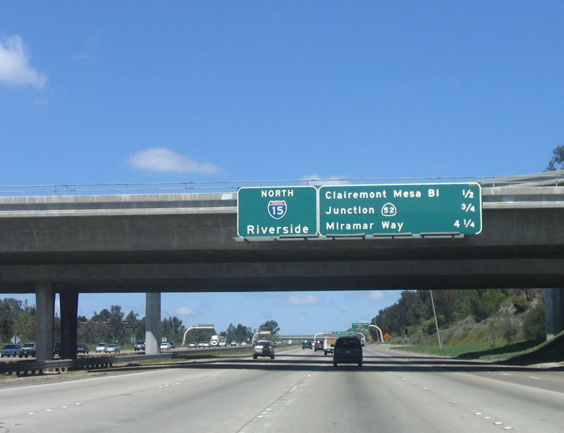
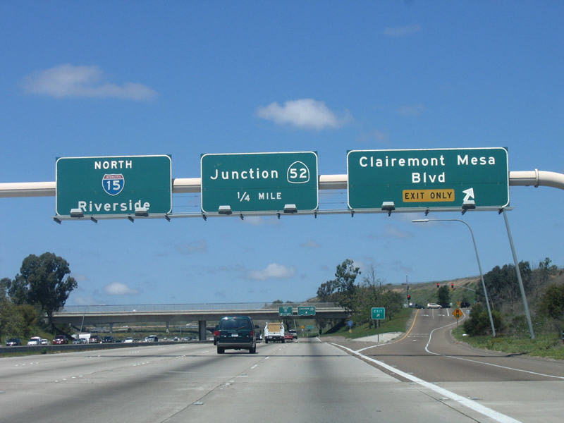
This mileage sign provides the distance to the next three exits on northbound Interstate 15: Exit 10, Clairemont Mesa Boulevard; Exit 11, California 52 (Soledad Freeway); and Exit 13, Miramar Way. There is no connection to Exit 12, California 163 south. Photo taken 04/09/06. |
|
The right lane becomes exit only for Exit 10, Clairemont Mesa Boulevard. Photo taken 04/09/06. |
|
Northbound Interstate 15 reaches Exit 10, Clairemont Mesa Boulevard. The next exit along northbound is Exit 11, California 52 (Soledad Freeway). Photo taken 04/09/06. |
|
Immediately after the Clairemont Mesa Boulevard interchange, northbound Interstate 15 reaches Exit 11, California 52 (Soledad Freeway). Interstate 15 departs Murphy Canyon and gains a bit of elevation as it approaches Miramar Marine Corps Air Station. Photo taken 04/09/06. |
|
Continuing north, the California 52 interchange comes into view. Interstate 15 serves as the lowest level, while California 52 crosses over the Interstate at the second level. A flyover ramp ("Citizens for 52 Bridge") connects eastbound California 52 with northbound Interstate 15. Photo taken 03/05/05.
|
|
Now on the transition ramp, the first exit connects to California 52 east to Mission Trails Regional Park and the city of Santee. While the freeway currently ends at California 125 north of Grossmont College, construction is underway to extend California 52 east to California 67 south of Lakeside. Photo taken 04/09/06. |
|
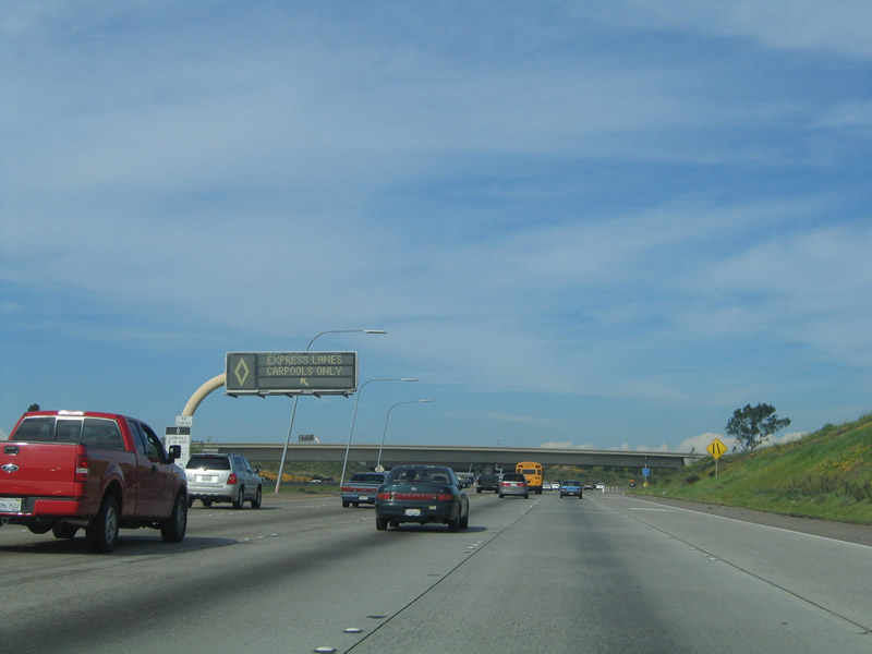
Back on the mainline, the next exit is the connection to the reversible high occupancy vehicle lanes. At the time this photo was taken, the express lanes were open for northbound use. Photo taken 03/05/05.
|
|
The second ramp within Exit 11 connects with California 52 (Soledad Freeway) west to the Miramar Landfill, Kearny Mesa, Clairemont, University City, La Jolla, and Pacific Beach. The freeway ends at Interstate 5 at the foot of Mount Soledad within Rose Canyon. Photo taken 04/09/06. |
|
|
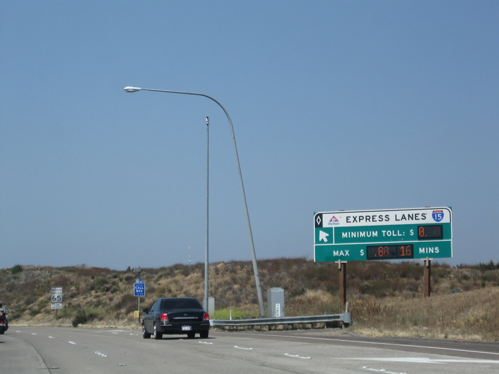
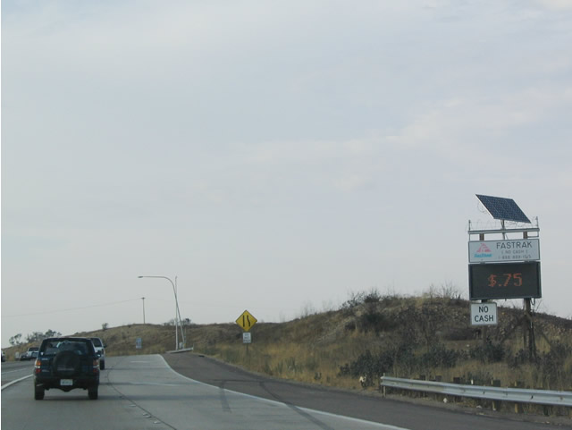
This variable message sign provides an indication as to how much the toll along northbound will cost. The toll varies by the amount of congestion on the freeway between the California 163 merge and the interchange with California 56. (The sign changed once the managed lanes opened from Sabre Springs north to Rancho Bernardo in 2008.) Photos taken 05/16/09 and 07/18/04. |
|
At the time this photo was taken, the express high occupancy vehicle lanes were open to traffic (evening commute, before construction changed this to a permanent two-way express lane configuration in 2011). When this ramp is closed, the variable message sign is changed to reflect that fact. Since that time, this area has changed with the expansion of the express lanes. Photo taken 07/18/04. |
|
|
A left exit ramp connects Interstate 15 north with the ramp to the Express Lanes (formerly the reversible High Occupancy Vehicle lanes as shown in the 2005 image). This transition ramp could be considered Exit 12 if given an exit number, but that is not the common practice for entry points to the Express Lanes. The junction with California 163 lies just beyond this ramp. The reversible lanes lead from here north to California 56 and onward to California 56, Via Rancho Parkway, and ultimately California 78 in Escondido. Photos taken 10/29/11 and 02/16/05. |
| Interstate 15 (Escondido Freeway) (Semper Fi Highway) north |
|
|
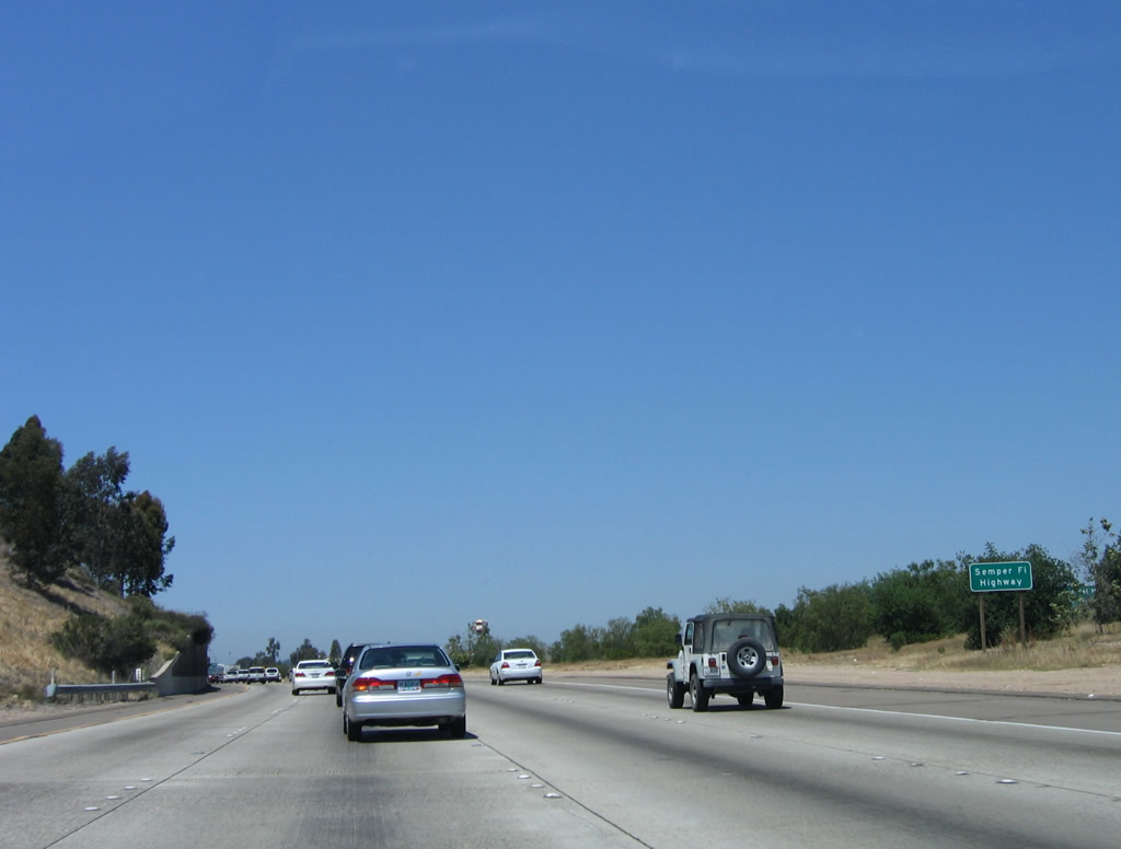
Upon entering military land, Interstate 15 is additionally known as the Semper Fi Highway. This designation continues until just prior to Exit 14, Pomerado Road. Semper Fi (or more fully Semper Fidelis) is the motto for the United States Marine Corps and means "always faithful." Photos taken 10/29/11 and 06/03/06. |
|
|
Interstate 15 merges with California 163 at this point. Along northbound, there is no access to southbound California 163. Since California 163 merges on the left, Interstate 15 traffic must merge left in order to avoid losing a lane or being forced into an exit only situation at Miramar Way. An end California 163 shield is visible at the left edge of Interstate 15. The 2011 picture shows the major change to the express lanes, which were widened. A retaining wall was built to support the expanded alignment. Photos taken 10/29/11 and 06/03/06. |
Page Updated October 29, 2011.