| U.S. 50 east |
|
|
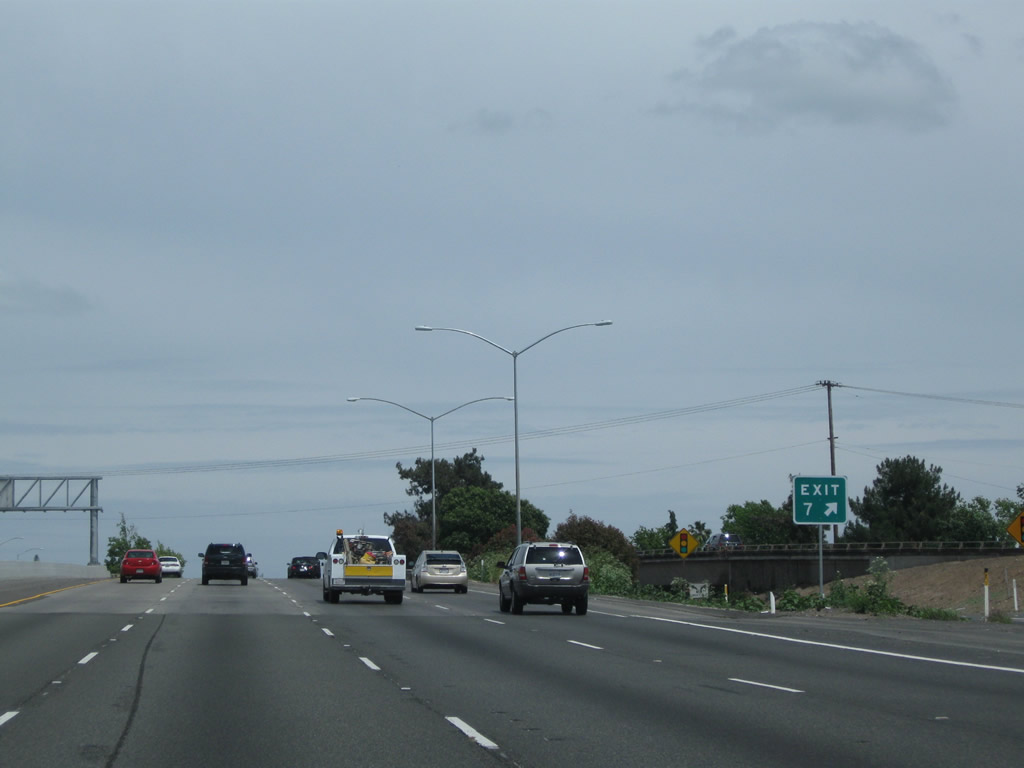
U.S. 50 (El Dorado Freeway) breaks free from Business Loop I-80 (Capital City [WX] Freeway), with traffic for eastbound Business Loop I-80 and southbound California 99 exiting right. Through traffic on U.S. 50 continues straight ahead under the stack interchange. The next exit along U.S., 50 east is Exit 7, 34th Street (one-half mile). Photos taken 05/14/11 and 04/02/05. |
|
|
The ramp from U.S. 50 to Business 80 east rises above the mainline of the El Dorado Freeway and splits between Business 80 and California 99. Shortly thereafter, U.S. 50 passes through the stack interchange between U.S. 50 east, Business Loop I-80 (Capital City Freeway) east, and California 99 south. U.S. 50's freeway was built in 1971 from the Business 80 interchange east to Bradshaw Road. Photos taken 05/14/11 and 04/02/05. |
|
|
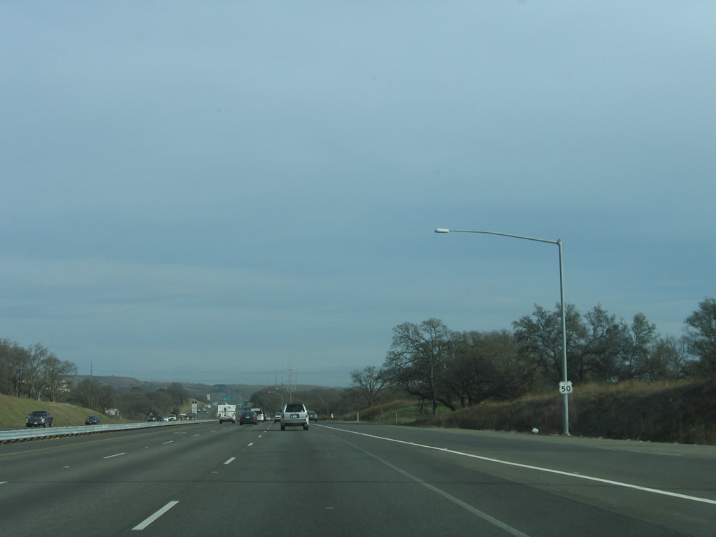
The next exit is Exit 7, 34th Street (500 feet). This guide sign was replaced in 2009. Photos taken 05/14/11 and 04/02/05. |
|
|
A ramp to Exit 7 (34th Street) is also available from the transition ramp from California 99 north to U.S. 50 (El Dorado Freeway) east as shown by this sign. The left lane departs onto 34th Street, while the right two lanes connect to U.S. 50 east. Photos taken 05/14/11 and 01/15/06. |
|
The gore point to Exit 7 is signed with the exit number. Photo taken 01/15/06. |
|
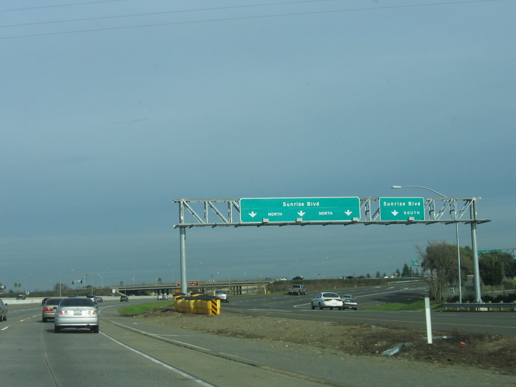
Traffic from Business Loop I-80 west and California 51 south merges onto U.S. 50 east. The traffic on the left carries U.S. 50 east mainline, while the lanes on the right carry traffic bring traffic from the eastbound business loop. Photo taken 04/06/12. |
|
|
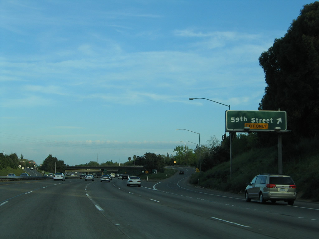
The next exit is Exit 8A, 59th Street (one mile). This sign was replaced in 2009. Photos taken 04/06/12 and 04/02/05. |
|
|
At the time the 2005 picture was taken, U.S. 50 featured four through lanes in each direction plus auxiliary lanes. A project to widen the freeway to began in 2007. Construction work continued into 2012. Photos taken 04/02/05 and 04/06/12. |
|
This mileage sign, added in 2009, provides the distance to the next three exits along U.S. 50 (El Dorado Freeway) east: Exit 8A, 59th Street. A separate mileage sign provides the distance to the second two exits: Exit 8B, 65th Street and Exit 9, Power Inn Road, Howe Avenue, and California 16 (Jackson Road) east. Photo taken 05/14/11. |
|
|
The right lane of U.S. 50 east becomes exit only for Exit 8A, 59th Street. A separate mileage sign used to be posted alongside the 59th Street guide sign to provide the distance to the second two exits: Exit 8B, 65th Street and Exit 9, California 16 (Jackson Road) east, Howe Avenue north, and Power Inn Road south. The mileage sign is now gone, and the exit sign was replaced in 2009 to include the exit number. Photos taken 04/06/12 and 04/02/05. |
|
This overhead mileage sign provides the distance to Rancho Cordova (seven miles), Placerville (39 miles), and South Lake Tahoe (99 miles). The U.S. 50 freeway ends in Placerville and enters Nevada after passing through South Lake Tahoe. Photo taken 04/02/05. |
|
|
Eastbound U.S. 50 (El Dorado Freeway) meets Exit 8A, 59th Street. Photos taken 05/14/11 and 04/02/05. |
|
The next exit along U.S. 50 east is Exit 8B, 65th Street (sign added in 2009; note HOV lane construction underway at this time). Photo taken 05/14/11. |
|
|
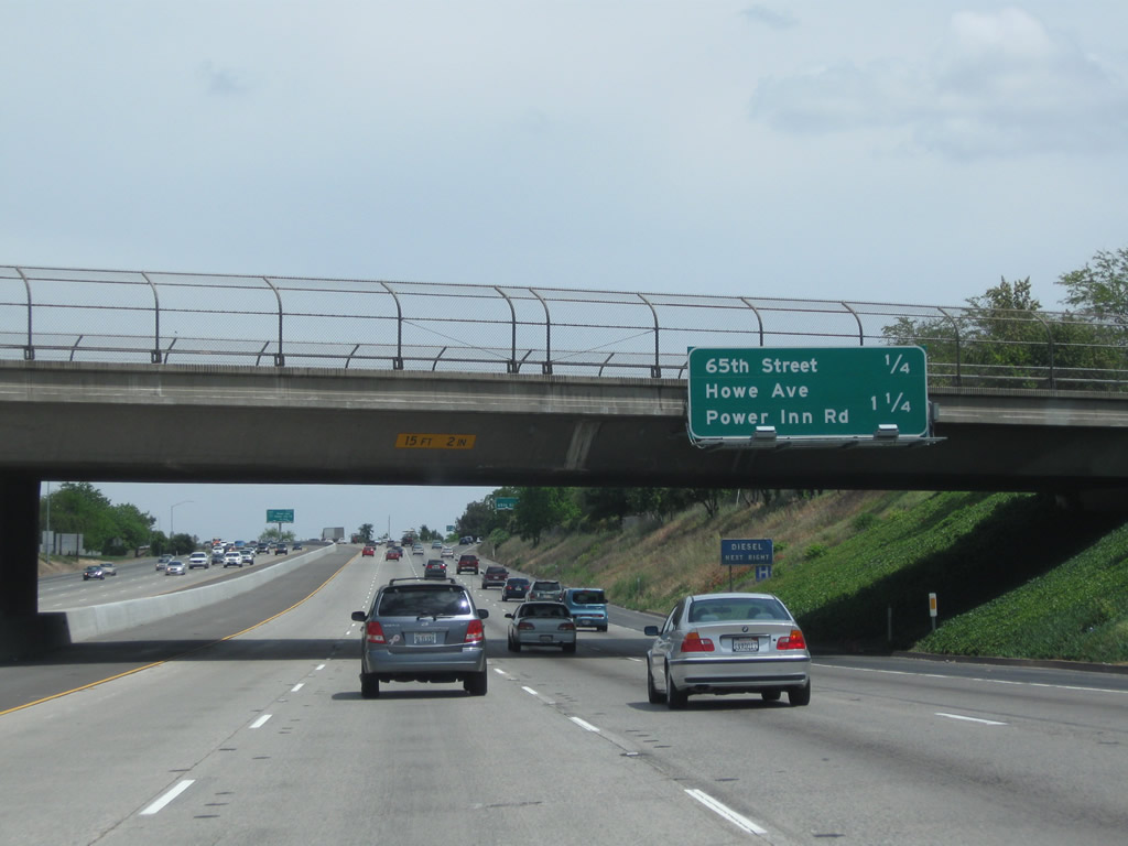
This mileage sign along eastbound U.S. 50 provides the distance to the next two exits: Exit 8B, 65th Street and Exit 9, California 16 east, Power Inn Road, and Howe Avenue. Photos taken 05/14/11 and 04/02/05. |
|
|
Eastbound U.S. 50 meets Exit 8B, 65th Street Expressway. Photos taken 04/06/12 and 04/02/05. |
|
|
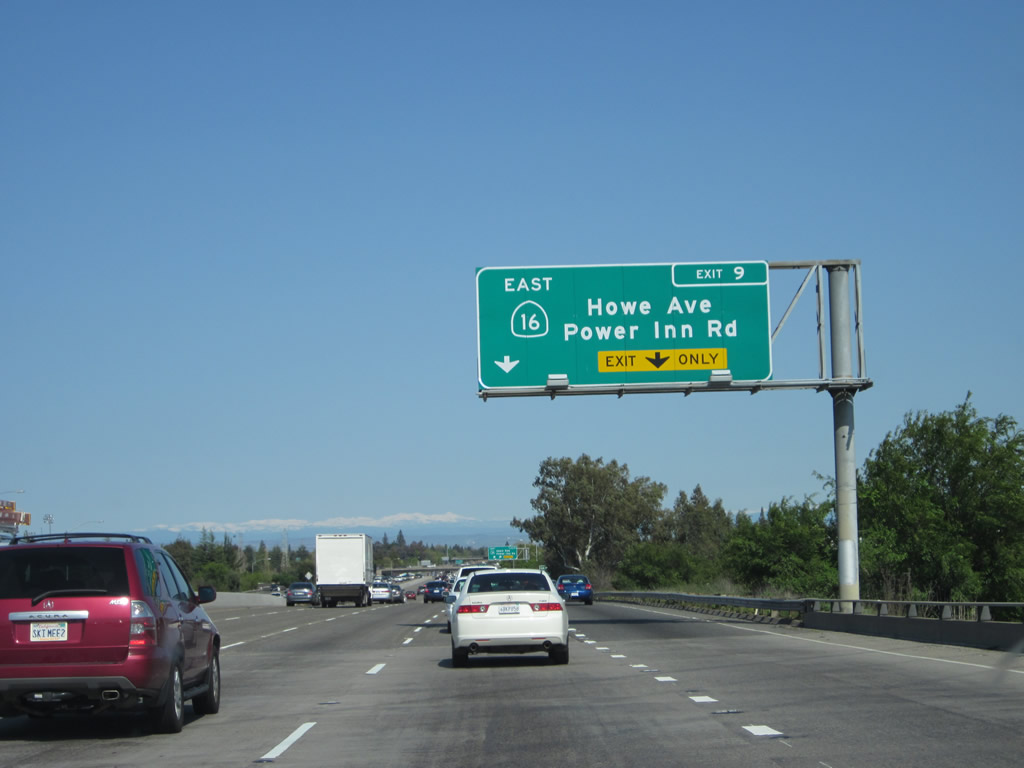
The next exit along U.S. 50 (El Dorado Freeway) east is Exit 9, Power Inn Road, Howe Avenue, and California 16 (Jackson Road) east. This exit number sign was posted in 2009, presumably to replace the sign shown in the next photobox. Photos taken 04/06/12 and 05/14/11. |
|
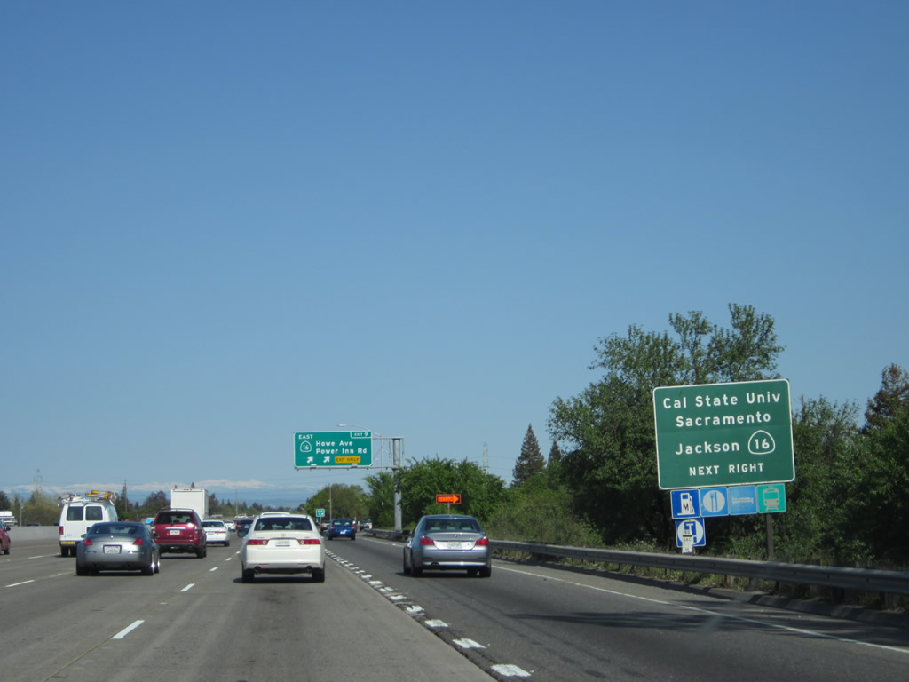
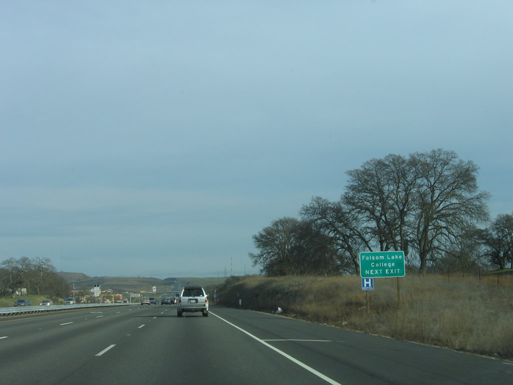
California 16 is currently a split route that has western and eastern sections. This exit serves the eastern section, which extends from this interchange southeast to California 49 north of Jackson. As for the western section, it begins at California 20 in Cache Creek Canyon just east of Clearlake and heads southeast to Interstate 5 at Woodland in Yolo County. Originally, California 16 connected these two segments by roughly following Interstate 5 (former California 99) and U.S. 40-50 through Sacramento. Maps showed California 16 cosigned with these original routes and with the freeways that were constructed in their place until the mid-1990s. Today, California 16 is seldom recognized as a through route in Sacramento, even though some maps still show it. Photo taken 04/02/05. |
|
This mileage sign, added in 2009, provides the distance to the next two exits along U.S. 50 (El Dorado Freeway) east: Exit 9, Power Inn Road, Howe Avenue, and California 16 (Jackson Road) east; and Exit 11, Watt Avenue. Photo taken 05/14/11. |
|
|
To California 16 east, follow Power Inn Road south to Jackson Road east. Howe Avenue, meanwhile, heads north from this interchange toward Arden, meeting Auburn Avenue and Business Loop I-80 north of the Arden Fair Mall. Photos taken 04/06/12 and 04/02/05. |
|
This mileage sign used to provide the distance to the next two exits along eastbound U.S. 50 (El Dorado Freeway): Exit 9, California 16 east, Power Inn Road south, and Howe Avenue north; and Exit 11, Watt Avenue. It is now gone. Photo taken 04/02/05. |
|
From Exit 9, California 16 resumes its southeasterly journey toward Plymouth/Drytown (California 124 and California 49). California 49 (Gold Country Highway) continues south into Jackson, Angels Camp, and Sonora. Photo taken 04/06/12. |
|
|
Eastbound U.S. 50 (El Dorado Freeway) meets Exit 9, Howe Avenue and Power Inn Road to California 16 (Jackson Road) east to Jackson. Photos taken 04/06/12 and 01/15/06. |
|
Two lanes depart from U.S. 50 east to Exit 9. Photo taken 04/06/12. |
|
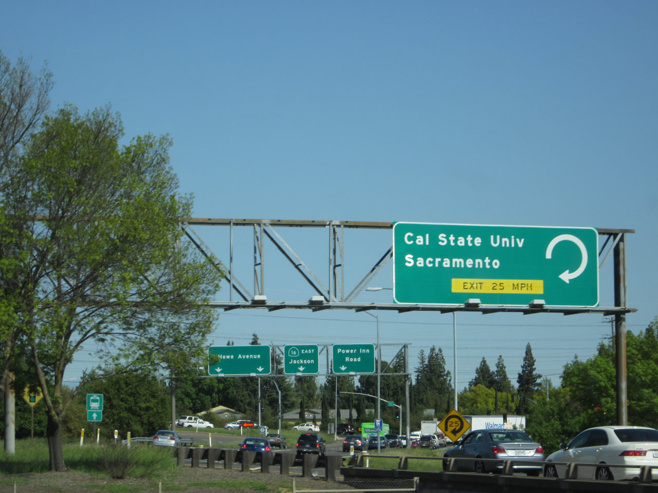
The off-ramp to California 16 is complicated. A loop ramp cuts off from the California 16 to California State University at Sacramento (Sac State), and the ramp again divides between Howe Avenue, California 16, and Power Inn Road. Photo taken 05/14/11. |
|
|
This mileage sign along U.S. 50 (El Dorado Freeway) east provides the distance to the next three exits: Exit 11, Watt Avenue; Exit 13, Bradshaw Road; and Exit 15, Mather Field and Rancho Cordova. Watt Avenue is a major north-south corridor that passes Arden Oaks and Town & Country Village en route to the Interstate 80/Business Loop I-80 interchange northeast of Sacramento. The older sign from 2005 that was replaced only provided the distance to the next exit, not the next three upcoming exits. Photos taken 05/14/11 and 04/02/05. |
|
This U.S. 50 east reassurance shield is posted after the on-ramp from Howe Avenue and Power Inn Road interchange. Photo taken 04/02/05. |
|
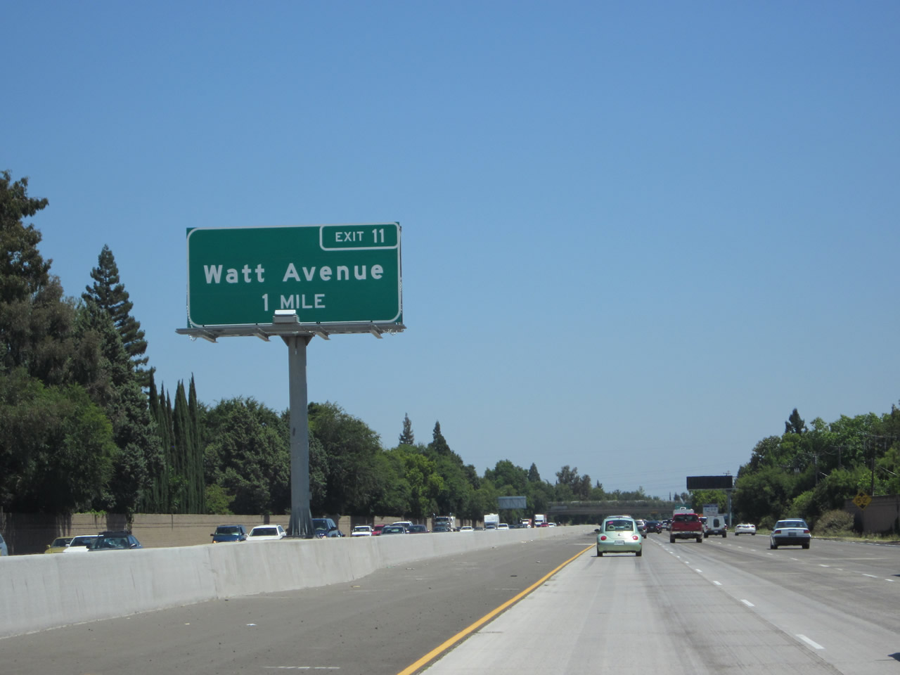
A one-mile advance sign for Exit 11 (Watt Avenue) with exit number was added in 2009. Photo taken 07/28/12. |
|
Use Watt Avenue north to the unincorporated community of Carmichael (population 61,762 as of the 2010 Census). This large suburb receives its services from the county of Sacramento and is not part of any incorporated city despite its large population. Photo taken 05/14/11. |
|
A variable message sign advised that a segment of U.S. 50 in the Sierra Nevada was closed on this day, and an alternate route via Missouri Flat Road and California 49 was advised for through traffic. Photo taken 05/14/11. |
|
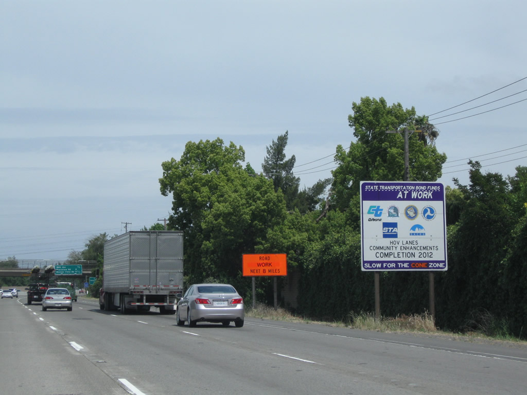
High occupancy vehicle lanes will be complete by 2012 along this stretch of U.S. 50. Photo taken 05/14/11. |
|
Prior to the installation of the new signs in 2009, the first exit number posted in advance of Exit 11 was this roadside sign. Since this photo was taken, some sign replacements have taken place that include the exit number in addition to this sign. Photo taken 01/15/06. |
|
Another mileage sign along U.S. 50 (El Dorado Freeway) east provides the distance to the next three exits: Exit 11, Watt Avenue; Exit 13, Bradshaw Road; and Exit 15, Mather Field Road and Rancho Cordova. Photo taken 05/14/11. |
|
|
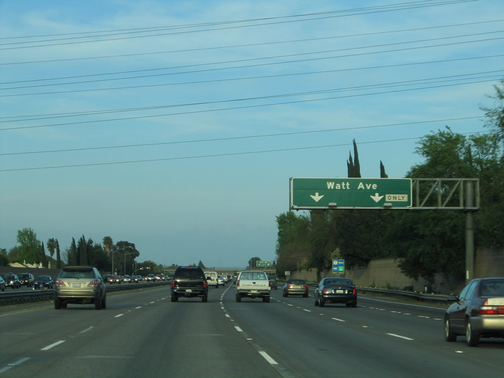
The right two lanes connect to Exit 11, Watt Avenue. A set of Sacramento Municipal Utility District (SMUD) power lines cross over the freeway at this point. Photos taken 04/06/12 and 04/02/05. |
|
This view looks east on U.S. 50 just prior to the Watt Avenue interchange. Photo taken 05/14/11. |
|
|
Eastbound U.S. 50 (El Dorado Freeway) meets Exit 11, Watt Avenue. Photos taken 04/06/12 and 01/15/06. |
|
|
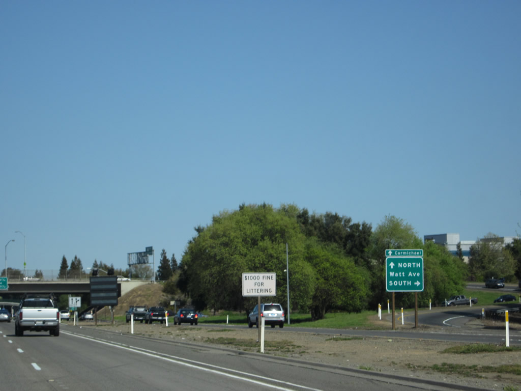
Upon departing the freeway at Exit 11, motorists enter a modified cloverleaf interchange. The first ramp connects to Watt Avenue south, while the second right connects to Watt Avenue north. Use Watt Avenue north to the community of Carmichael. Photo taken 04/06/12. |
|
|
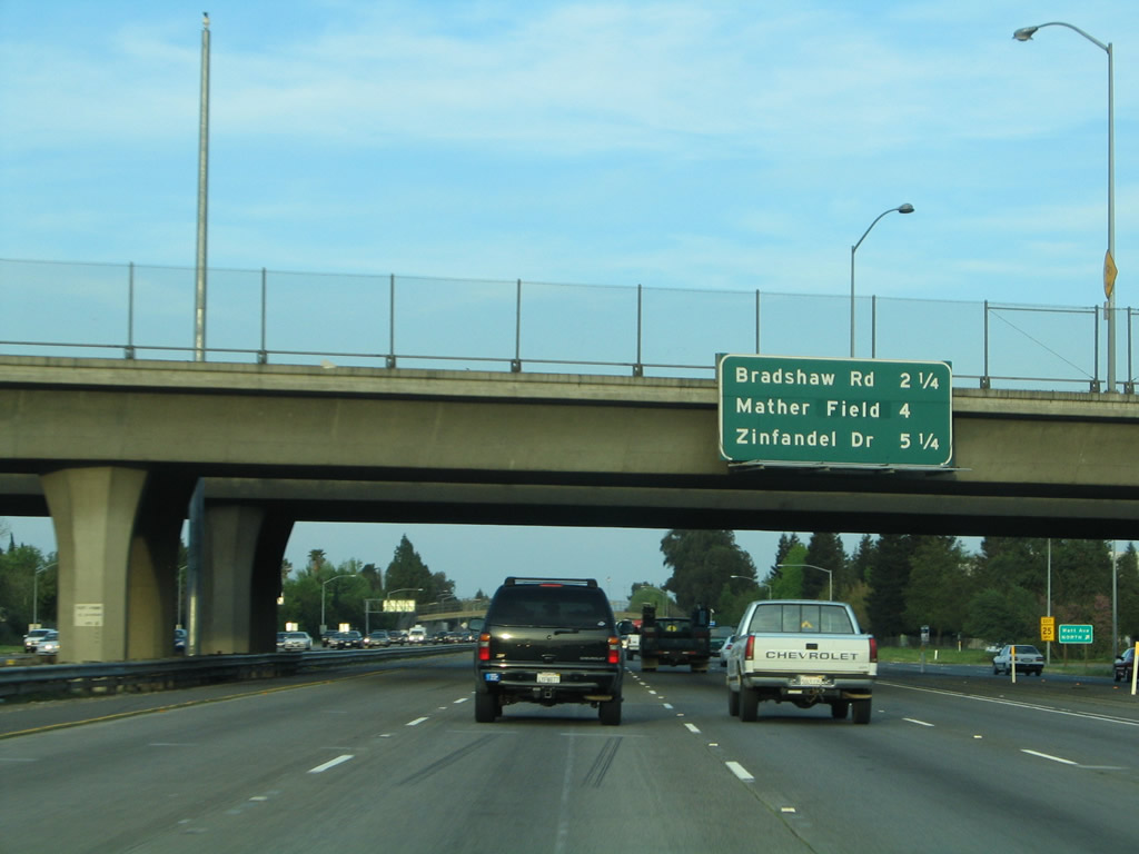
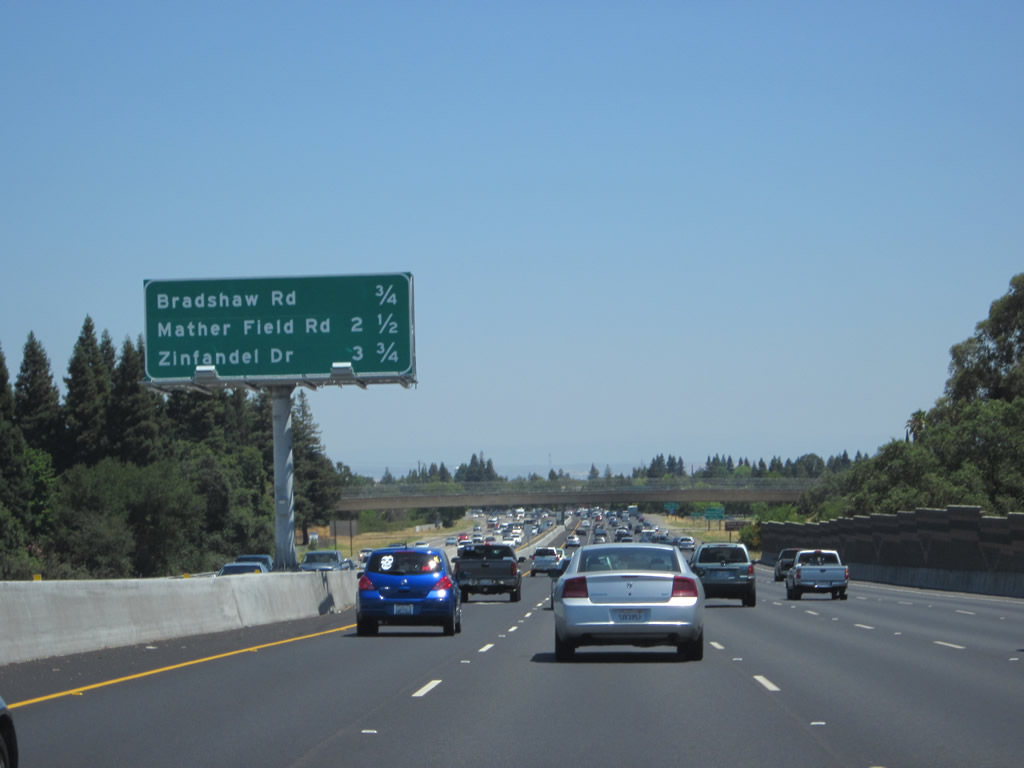
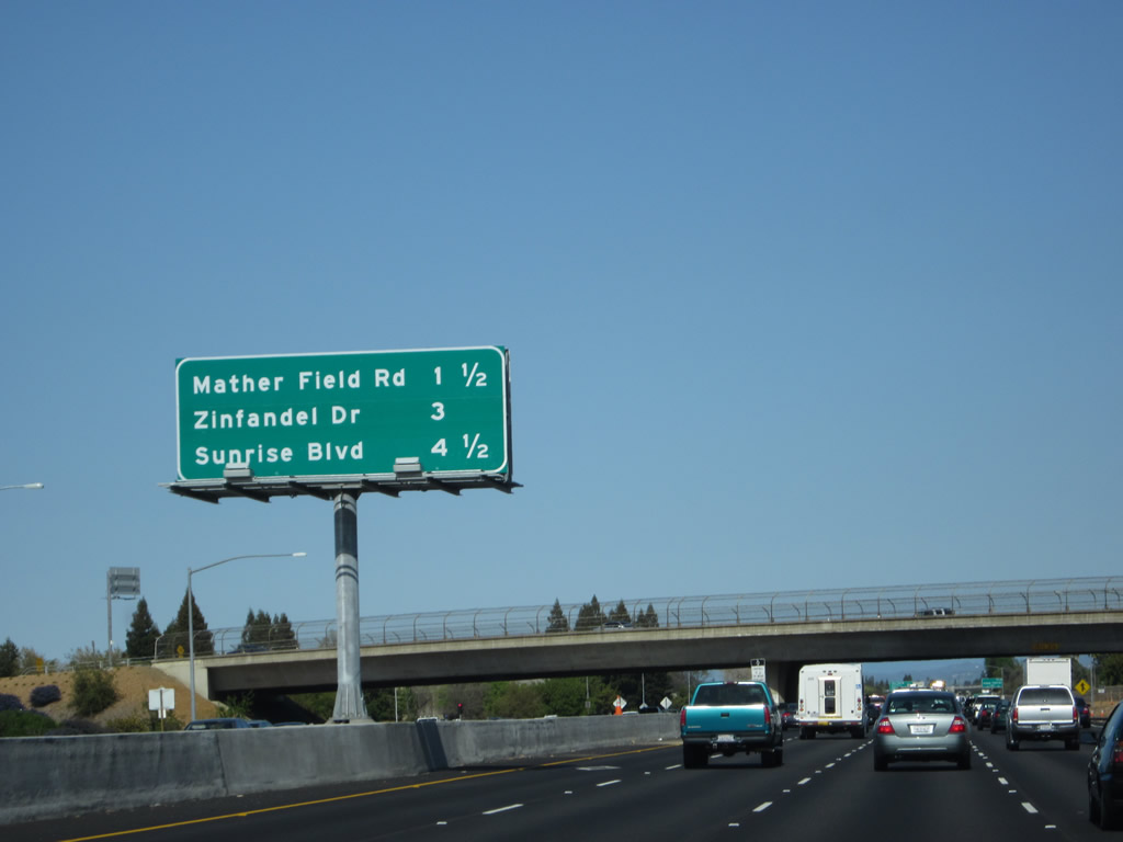
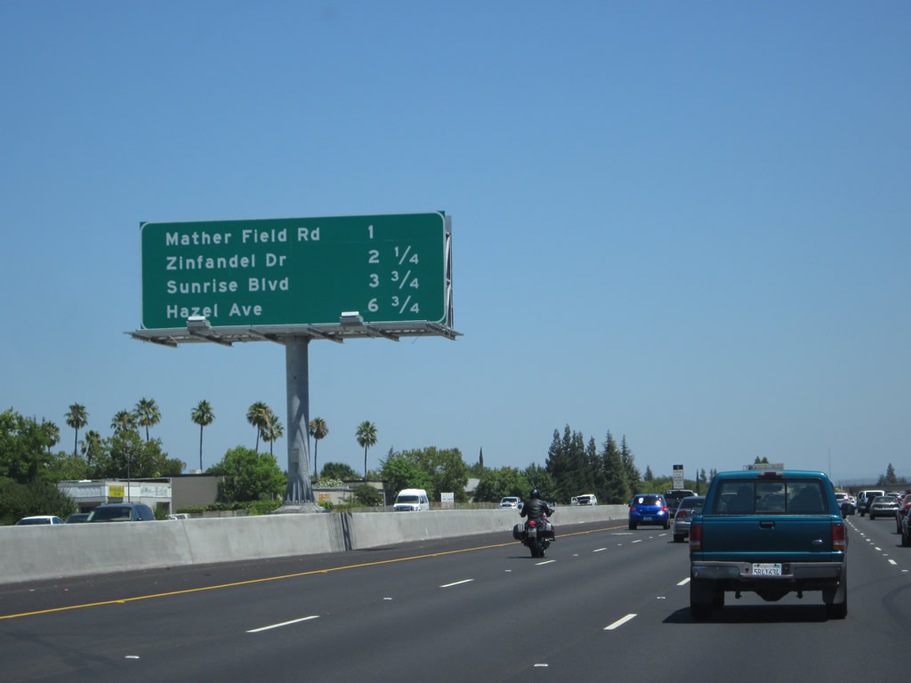
This mileage sign provides the distance to the next three exits along eastbound U.S. 50 (El Dorado Freeway): Exit 13, Bradshaw Road; Exit 15, Mather Field Road to Rancho Cordova; and Exit 17, Zinfandel Drive. Photos taken 05/14/11 and 04/02/05. |
|
A pedestrian bridge passes over the freeway. Photo taken 04/06/12. |
|
|
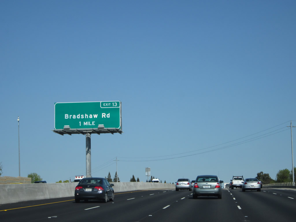
U.S. 50 approaches Exit 13, Bradshaw Road (one mile). This sign was also replaced between 2006 and 2011. Bradshaw Road heads north to Folsom Boulevard and south to Walsh Station (where it meets California 16) and Elk Grove (where it meets Sacramento County E-2). Photos taken 04/06/12 and 01/15/06. |
|
Another mileage sign again provides the distance to the next three exits along eastbound U.S. 50 (El Dorado Freeway): Exit 13, Bradshaw Road; Exit 15, Mather Field Road to Rancho Cordova; and Exit 17, Zinfandel Drive. Photo taken 01/15/06. |
|
Use Bradshaw Road to American River Parkway and River Bend Park (formerly Goethe Park). Photo taken 01/15/06. |
|
|
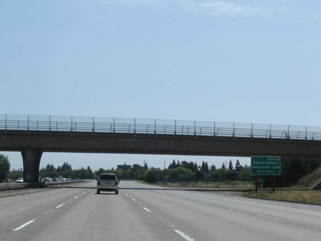
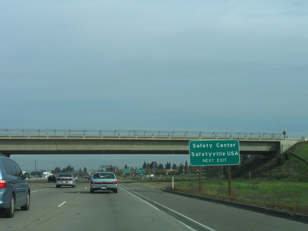
This exit also serves Safety Center and Safetyville USA. The sign was replaced in 2009 to incorporate the exit number for Bradshaw Road. Photos taken 06/20/09 and 01/15/06. |
|
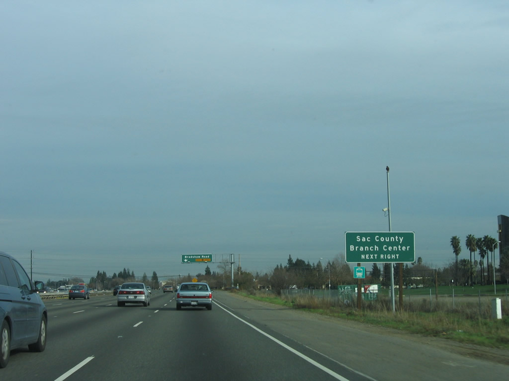
Also at this exit is a County of Sacramento branch center for county government as well as a light rail station. Currently the light rail runs from Folsom to downtown Sacramento. Photo taken 01/15/06. |
|
|
The right two lanes of U.S. 50 (El Dorado Freeway) east connect to Exit 13, Bradshaw Road. Photos taken 05/14/11 and 04/02/05. |
|
|
Eastbound U.S. 50 (El Dorado Freeway) meets Exit 13, Bradshaw Road. The section of U.S. 50 from Bradshaw Road to Zinfandel Drive was built in 1973. Photos taken 07/28/12 and 01/15/06. |
|
This mileage sign provides the distance to the next three exits along eastbound U.S. 50: Exit 15, Mather Field Road; Exit 17, Zinfandel Drive; and Exit 18, Sacramento County E-2 (Sunrise Boulevard). Photo taken 04/06/12. |
|
U.S. 50 enters the city of Rancho Cordova ("City Life. Reinvented."). Rancho Cordova had a population of 64,776 as of the 2010 Census and incorporated on July 4, 2003. In addition to serving as a suburb of Sacramento, Rancho Cordova also has an active employment center. Photo taken 07/30/11. |
|
This mileage sign, formerly mounted on the overpass, provided the distance to the next two exits along eastbound U.S. 50: Exit 15, Mather Field Road to Rancho Cordova and Exit 17, Zinfandel Drive. This sign was relocated to the prior mileage sign (and expanded to include three exits). Photo taken 01/15/06. |
|
|
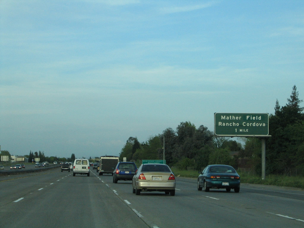
The next exit along eastbound U.S. 50 (El Dorado Freeway) is Exit 15, Mather Field Road to Rancho Cordova (one mile). Rancho Cordova is notable for Sacramento Mather Airport (Mather Field) and a Mormon Temple (the latter of which was dedicated on September 3, 2006). Photos taken 07/30/11 and 04/02/05. |
|
A rare interchange sequence sign with four interchanges comes next. This sign provides the distance to Exit 15, Mather Field Road; Exit 17, Zinfandel Drive; Exit 18, Sacramento County E-2 (Sunrise Boulevard); and Exit 21, Sacramento County E-3 (Hazel Avenue). Photo taken 07/28/12. |
|
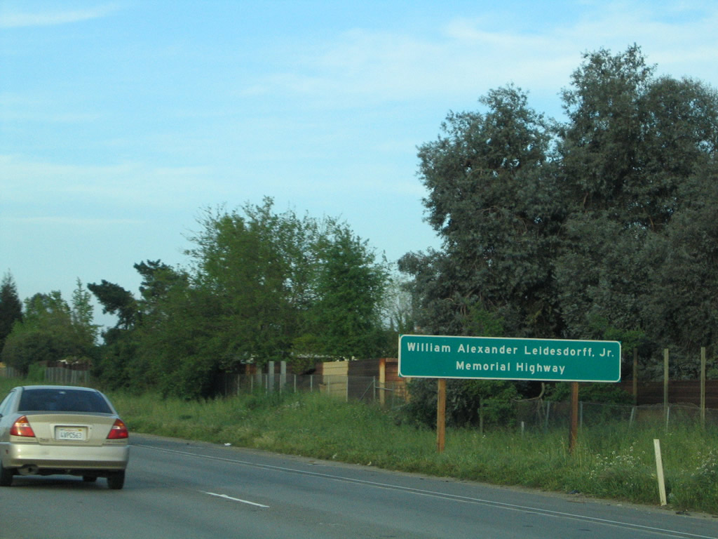
U.S. 50 (El Dorado Freeway) is also known as the William Alexander Leidesdorff, Jr. Memorial Highway. Photo taken 01/15/06. |
|
Use Exit 15 to Mather Regional Park. Photo taken 04/06/12. |
|
|
The right two lanes of U.S. 50 (El Dorado Freeway) connect to Exit 15, Mather Field Road. Note the changes in pavement (from concrete to asphalt overlay) between 2011 and 2012. Additional auxiliary lanes were completed and in use by summer 2012. Photos taken 07/28/12 and 07/30/11. |
|
|
Eastbound U.S. 50 (El Dorado Freeway) meets Exit 15, Mather Field Road north to Folsom Boulevard (old U.S. 50) and south to Mather Field. Photos taken 05/14/11 and 01/15/06. |
|
|
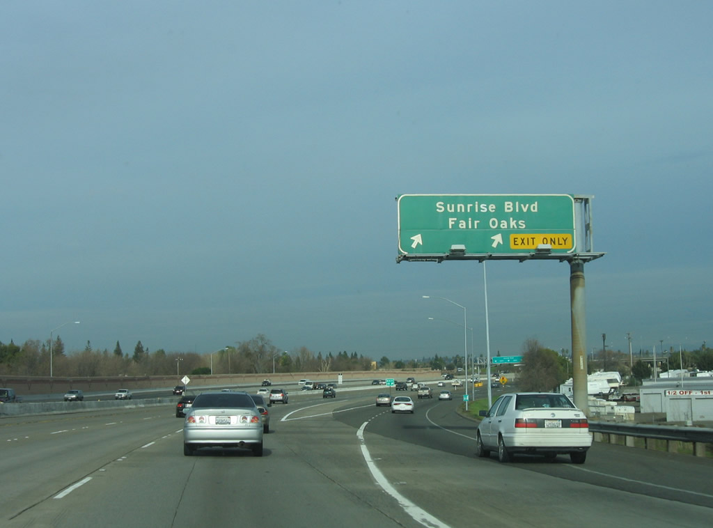
The next two exits along eastbound U.S. 50 (El Dorado Freeway) are Exit 17, Zinfandel Drive, and Exit 18, Sacramento County E-2 (Sunrise Boulevard) to Fair Oaks. This sign was replaced and converted from a mileage interchange sequence sign to the current advance sign solely for Exit 17. Photos taken 04/06/12 and 01/15/06. |
|
Another interchange sequence sign with four interchanges comes next. This sign provides the distance to Exit 15, Mather Field Road; Exit 17, Zinfandel Drive; Exit 18, Sacramento County E-2 (Sunrise Boulevard); Exit 21, Sacramento County E-3 (Hazel Avenue); and Exit 23, Folsom Boulevard. Omitted from this sign is Exit 22, Aerojet Road. Photo taken 07/28/12. |
|
All motorist services are available at Exit 17, Zinfandel Drive. Photo taken 05/14/11. |
|
The right two lanes will connect to Exit 17, Zinfandel Drive. An exit number sign (part of a larger sign replacement project) was added in 2009. The new sign was moved from its former location (and no sign is posted on the pedestrian bridge). Photo taken 04/06/12. |
|
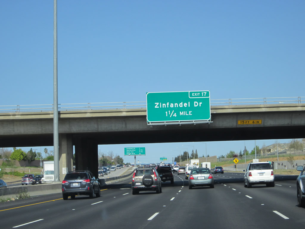
U.S. 50 (El Dorado Freeway) east approaches Exit 17, Zinfandel Drive, one-half mile. Photo taken 04/02/05. |
|
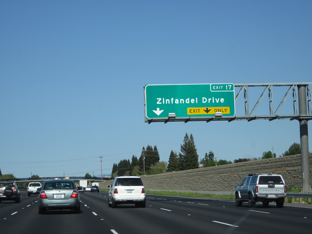
The right two lanes connect to Exit 17, Zinfandel Drive. This sign was removed and not directly replaced. Photo taken 04/02/05. |
|
|
Eastbound U.S. 50 (El Dorado Freeway) meets Exit 17, Zinfandel Drive. Use Zinfandel Drive north to meet old U.S. 50 (Folsom Boulevard) and south to International Drive. Photos taken 07/30/11 and 01/15/06. |
|
|
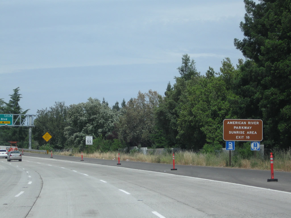
This mileage sign provides the distance to three of the next four exits along eastbound U.S. 50: Exit 18, Sacramento County E-2 (Sunrise Boulevard) to Fair Oaks; Exit 21, Sacramento County E-3 (Hazel Avenue); and Exit 23, Folsom Boulevard (Old U.S. 50). Again omitted is Exit 22, Aerojet Road. Neither of the two county route shields appears on the approach guide signs, and the independently mounted trailblazer signs have been mostly removed from along the freeway as well. Photos taken 07/28/12 and 07/30/11. |
|
|
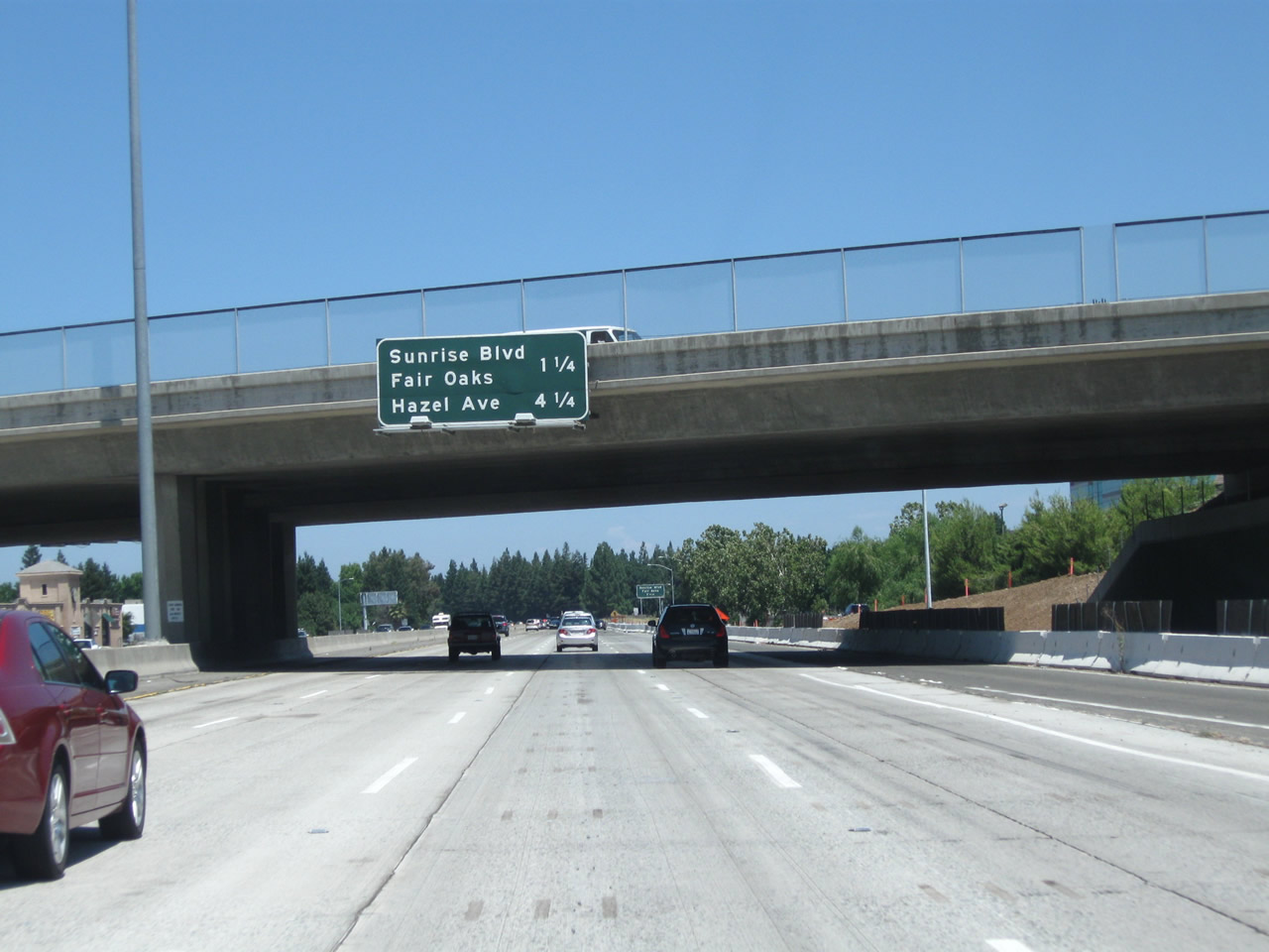
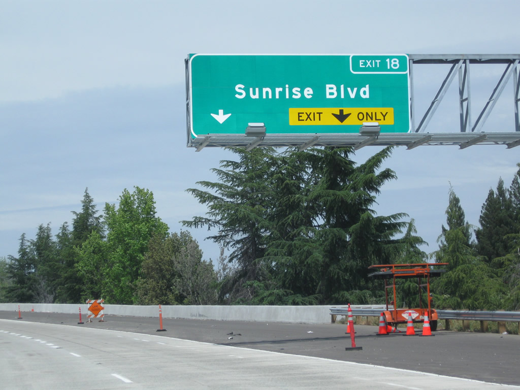
The next exit along eastbound U.S. 50 (El Dorado Freeway) is Exit 18, Sacramento County E-2 (Sunrise Boulevard). Heading south, Sacramento County E-2 turns southwest, angling toward California 99 via Grant Line Road, ending at Exit 284 on that freeway. Photos taken 07/28/12 and 07/30/11. |
|
|
Looking north, Sacramento County E-2 follows Sunrise Boulevard north into Gold River, Fair Oaks, Citrus Heights, and Roseville before reaching Interstate 80 southwest of its junction with California 65. Photos taken 05/14/11 and 01/15/06. |
|
|
The right two lanes connect to Exit 18, Sunrise Boulevard. Photos taken 05/14/11 and 01/15/06. |
|
|
Eastbound U.S. 50 (El Dorado Freeway) meets Exit 18, Sacramento County E-2 (Sunrise Boulevard). Note the pavement changes between 2006 and 2012. Photos taken 07/31/12 and 01/15/06. |
|
Looking at the exit ramp, four lanes depart from the freeway, with the left three lanes linking to Sacramento County E-2 (Sunrise Boulevard) north and the right lane connecting to Sacramento County E-2 (Sunrise Boulevard) south. Photo taken 01/15/06. |
|
A U.S. 50 east route marker is posted between Sunrise Boulevard and Hazel Avenue. Photo taken 05/14/11. |
|
This mileage sign along eastbound U.S. 50 provides the distance to three of the next four exits: Exit 21, Sacramento County E-3 (Hazel Avenue) north; Exit 22, Aerojet Road (not listed), Exit 23, Folsom Boulevard; and Exit 25, Prairie City Road. Photo taken 01/15/06. |
|
The next exit along U.S. 50 (El Dorado Freeway) east is Exit 21, Sacramento County E-3 (Hazel Avenue) north. This series of exit number signs (from here east through Folsom toward El Dorado County) were largely installed in 2005. Photo taken 01/15/06. |
|
Use Hazel Avenue to Orangevale, an unincorporated community of Sacramento County (population was 33,960 as of the 2010 Census). Photo taken 07/30/11. |
|
The right two lanes connect to Exit 21, Sacramento County E-3 (Hazel Avenue) north. Sacramento County E-3 follows Hazel Avenue north from this interchange over the American River to Orangevale, then changes into Sierra College Boulevard as it continues north into the Placer communities of Roseville, Rocklin, and Loomis. Photo taken 01/15/06. |
|
Eastbound U.S. 50 reaches Exit 21, Sacramento County E-3 (Hazel Avenue) north. Photo taken 01/15/06. |
|
The next two exits along U.S. 50 east are Exit 22, Aerojet Road (not signed here) and Exit 23, Folsom Boulevard/Historic U.S. 50. Photo taken 01/15/06. |
|
|
Eastbound U.S. 50 (El Dorado Freeway) reaches Exit 22, Aerojet Road. Although not signed here, the next exit along eastbound is Exit 23, Folsom Boulevard (Historic U.S. 50). Photos taken 07/28/12 and 01/15/06. |
|
|
The next three exits (Exit 23, 25, and 27) all serve the city of Folsom and Folsom Lake. One of the largest recreational lakes in the immediate vicinity of Sacramento is Folsom Lake (dammed American River), which is located northeast of U.S. 50. The historic city of Folsom is located downriver from the dam. Photos taken 07/28/12 and 01/15/06. |
|
|
The right two lanes connect to Exit 23, Folsom Boulevard. This is the old alignment of U.S. 50 and serves as the main route into the city of Folsom ("Distinctive by Nature"). Sitting at an elevation of 220 feet, Folsom is the point where U.S. 50 leaves the flat Central Valley and begins to march up the foothills toward the Sierra Nevada. Incorporated on April 20, 1946, Folsom had a population of 51,884 people as of the 2000 Census. Some of the notable features of Folsom include the historic Rainbow Bridge and a vast network of bike paths. Skirting Lake Natoma to the northwest, Folsom Boulevard provides access to old U.S. 50 through downtown Folsom, then splits north past Folsom Lake and changes into Auburn-Folsom Road en route to Auburn and Interstate 80. Photos taken 07/28/12 and 01/15/06. |
|
Use Folsom Boulevard east to the Folsom Powerhouse State Historic Park. The power house began operating along the American River in Folsom, delivering power to the region starting in the late 1800s. Today the power house is preserved as a museum and state historic landmark. Photo taken 07/28/12. |
|
|
Eastbound U.S. 50 (El Dorado Freeway) reaches Exit 23, Folsom Boulevard (Historic U.S. 50). Although there are no signs to indicate the historic route for U.S. 50 from the mainline freeway, a few green, text-only "Historic U.S. 50" reassurance markers were placed by the city of Folsom near downtown (Riley Street and Sutter Street). Photos taken 07/28/12 and 01/15/06. |
|
|
Upon exiting, turn left on Folsom Boulevard to follow old U.S. 50 to downtown Folsom and the state historic park. Two signs are posted on the off-ramp; Folsom Boulevard is an expressway from here east into downtown Folsom. Photos taken 06/20/09 and 05/14/11. |
|
Back on the mainline, this mileage sign along eastbound U.S. 50 provides the distance to the next two exits: Exit 25, Prairie City Road and Exit 27, East Bidwell Street and Scott Road. Both of these exits serve the city of Folsom. Photo taken 01/15/06. |
|
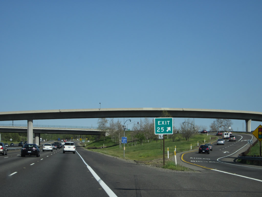
The next exit along eastbound U.S. 50 is Exit 25, Prairie City Road. The bypass of Folsom dates to 1965, with a major improvement to the Prairie City Road interchange in 1998. Photo taken 01/15/06. |
|
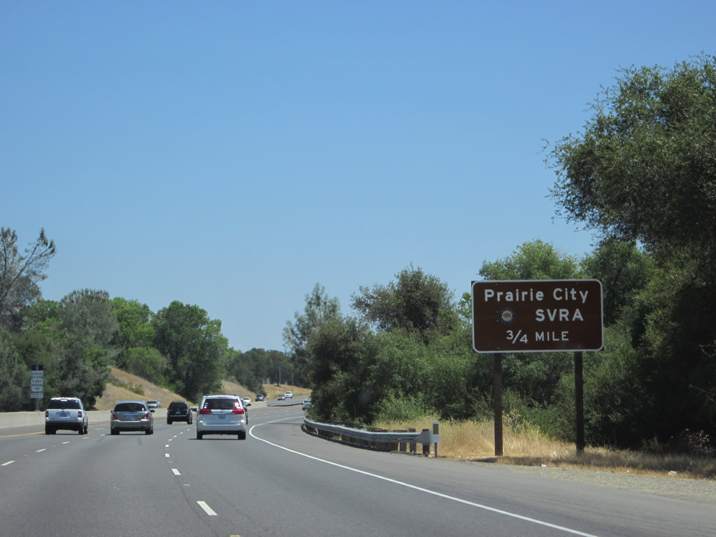
Use Exit 25 to Prairie City State Vehicular Recreation Area. Photo taken 07/28/12. |
|
Eastbound U.S. 50 (El Dorado Freeway) reaches Exit 25, Prairie City Road to Folsom. Photo taken 01/15/06. |
|
The exit number is again posted at the gore point. Photo taken 04/06/12. |
|
Two bridges cross over U.S. 50 at this point. One is a flyover ramp from southbound Prairie City Road to eastbound U.S. 50, and the other is the actual Prairie City Road overpass. Photo taken 01/15/06. |
|
A single U.S. 50 reassurance shield without directional banner is posted shortly after the on-ramp from Prairie City Road. Photo taken 01/15/06. |
|
The next exit along U.S. 50 (El Dorado Freeway) east is Exit 27, Scott Road and East Bidwell Street to Folsom (one mile). Photo taken 01/15/06. |
|
Use Exit 27 (Scott Road and East Bidwell Street) to Folsom Lake College. Photo taken 01/15/06. |
|
The right two lanes of U.S. 50 (El Dorado Freeway) east connect to Exit 27. Photo taken 01/15/06. |
|
Eastbound U.S. 50 (El Dorado Freeway) reaches Exit 27, Scott Road and East Bidwell Street to Folsom. Photo taken 01/15/06. |
|
Now on the off-ramp to Exit 27, turn right (south) to Scott Road or left (north) to East Bidwell Street. Photo taken 01/15/06. |
|
A traffic signal governs the flow of traffic between the U.S. 50 east off-ramp and Scott Road and East Bidwell Street. The El Dorado Hills begin in earnest just east of this point. Photo taken 01/15/06. |
|
|
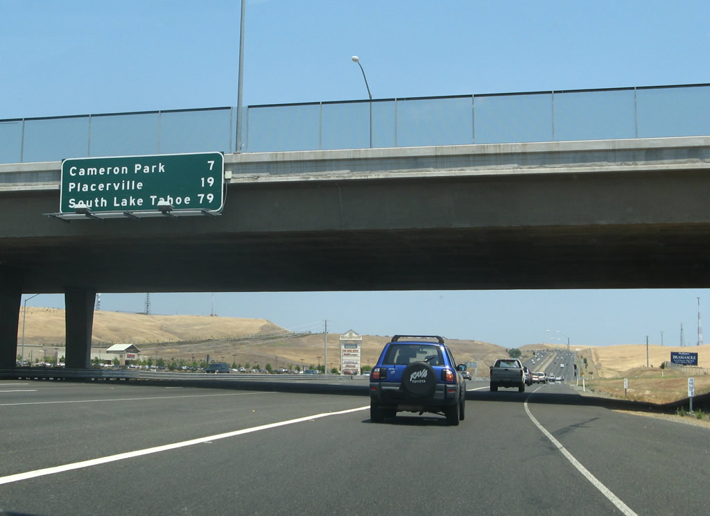
Back on the mainline, an overhead mileage sign mounted on the Scott Road / East Bidwell Street overpass provides the distance to Cameron Park (seven miles), Placerville (19 miles), and South Lake Tahoe (79 miles). Photos taken 07/28/12 and 07/08/07. |
|
A climbing lane briefly expands eastbound U.S. 50 to four lanes. From here it's all "uphill" as we travel through the foothills toward the Sierra Nevada, Echo Pass, and Lake Tahoe. The sign shown in the next picture was added by 2012 for the California Welcome Center at Exit 30 in El Dorado Hills. Photo taken 02/17/07. |
|
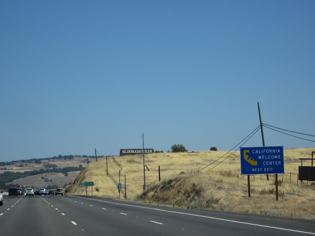
Use Exit 30 for the California Welcome Center in El Dorado Hills. The welcome center is located on the south side of the freeway east of Latrobe Road and north of White Rock Road on Town Center Boulevard. Photo taken 07/28/12. |
|
The next two exits along U.S. 50 east are Exits 30A, Latrobe Road south and Exit 30B, El Dorado Hills Boulevard north (one mile). Photo taken 02/17/07. |
|
The California Welcome Center in El Dorado Hills offers tourist information, restrooms, and related services. Check the official website for operating hours. Photo taken 07/28/12. |
|
|
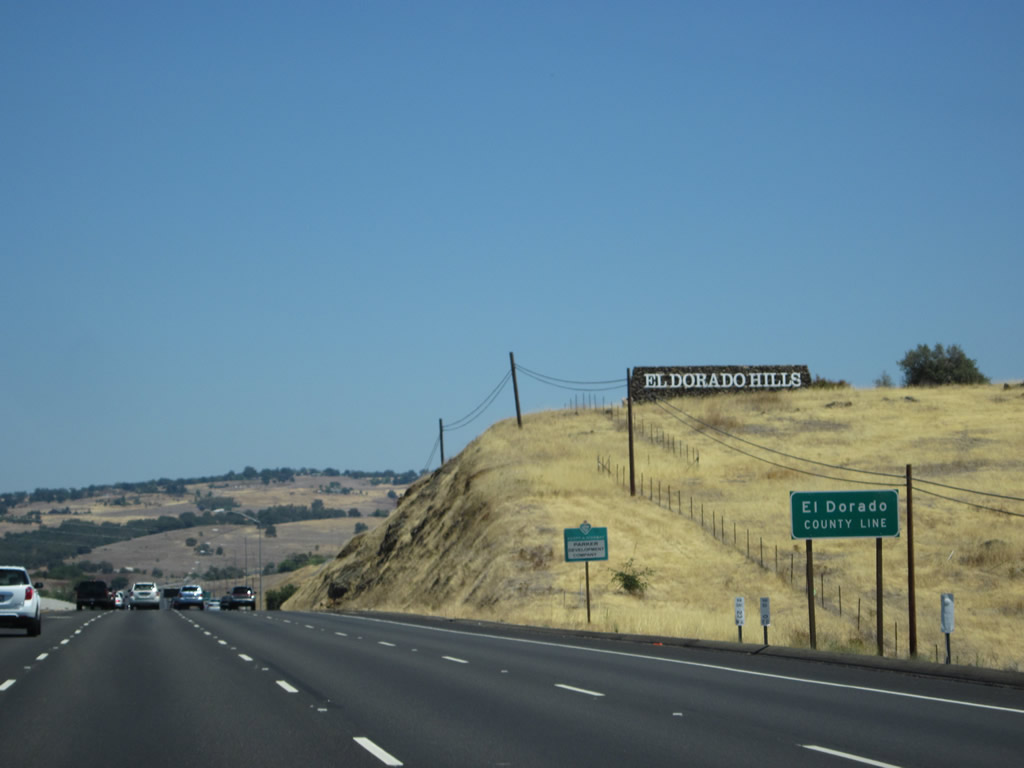
U.S. 50 leaves Sacramento County and enters El Dorado County and the unincorporated community of El Dorado Hills. A growing community of master planned residential developments, El Dorado Hills had a population of 18,016 people as of the 2000 Census. Most residents associate with the amenities in nearby Folsom, and some housing developments come very close to the Sacramento-El Dorado County line, helping to blur the distinction between the two areas. Photos taken 07/28/12 and 02/17/07. |
Page Updated September 22, 2012.