| Business Loop I-80 and U.S. 30 east |
|
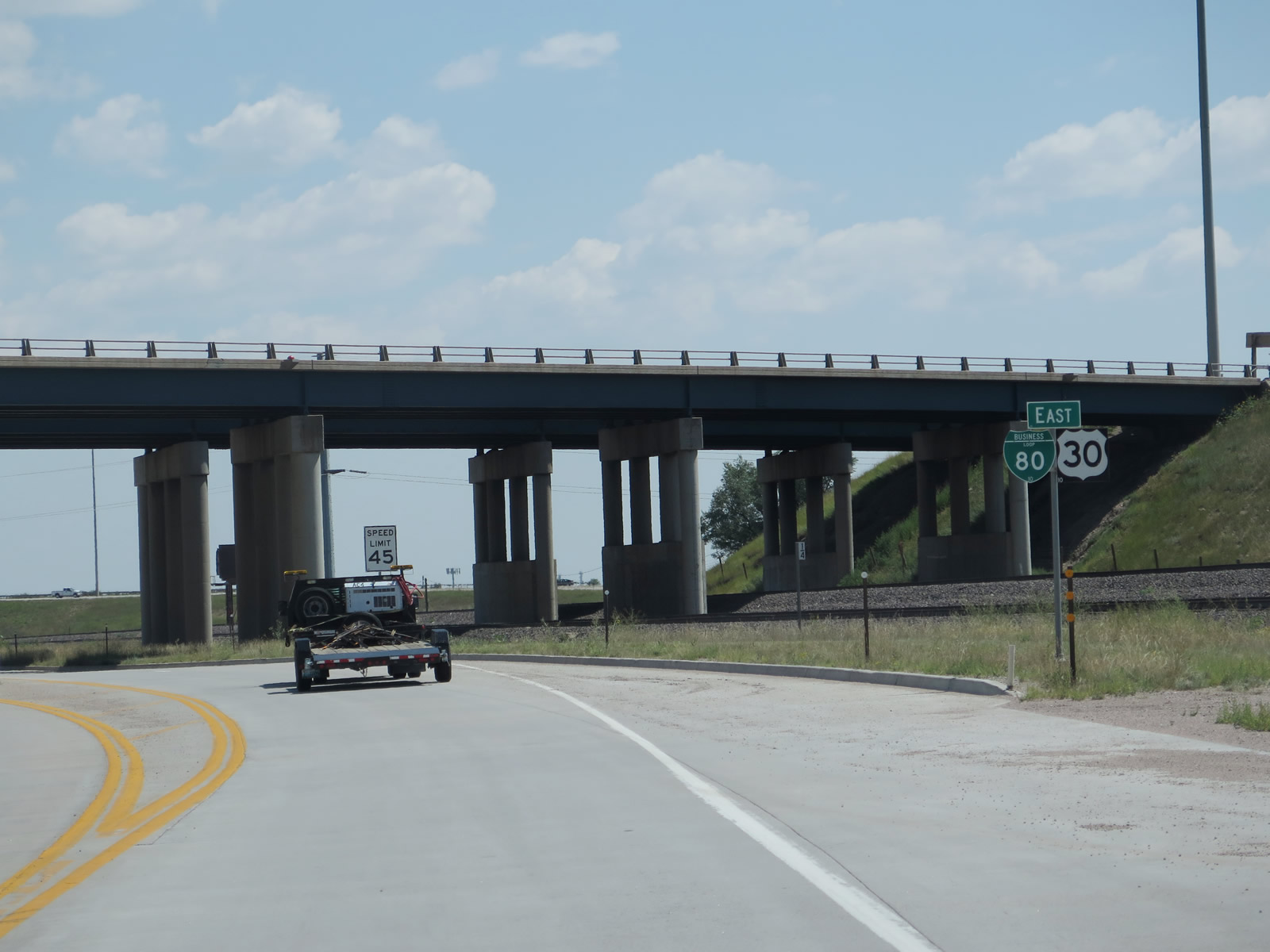
Starting in western Cheyenne, Business Loop I-80 and U.S. 30 follow Lincolnway through town. After departing from Interstate 80 at Exit 358 at a hybrid half-diamond/folded diamond interchange, we find the first reassurance shield assembly for both Business Loop I-80 and U.S. 30 east. This point marks the eastern terminus of Wyoming 225 / Otto Road (former U.S. 30 / Historic Lincoln Highway). After this shield, Lincolnway passes under Interstate 80. Photo taken 08/11/14. |
|
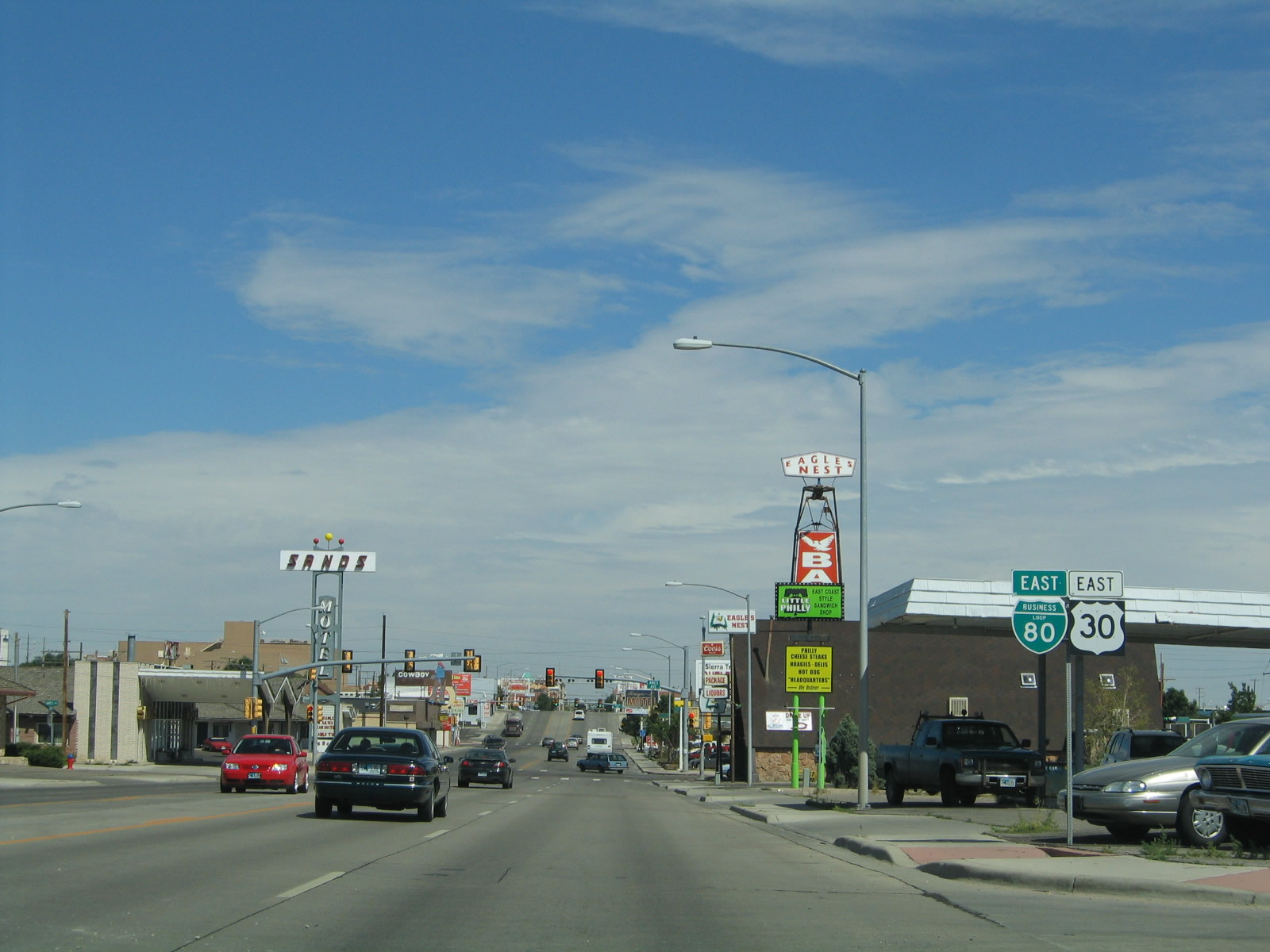
The next left from Business Loop I-80 and U.S. 30 (Lincolnway) connect to Little America, a hotel that features a golf course. Little America has another hotel and travel center along Interstate 80 west of here in Little America, Wyoming, about 300 miles west of here (midway between Green River and Lyman). After the Little America intersection, the business route approaches the on ramp to Interstate 25 and U.S. 87 south to Fort Collins and Denver. Photo taken 08/11/14. |
|
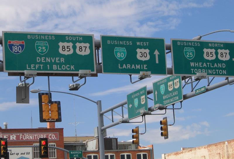
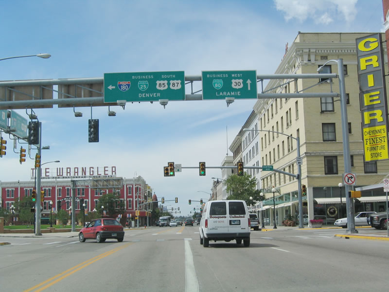
Continuing east, the next left turn connects to Interstate 25 and U.S. 87 south to Interstate 80, Fort Collins, and Denver. Photo taken 08/11/14. |
|
Business Loop I-80 and U.S. 30 (Lincolnway) eastbound approach and pass under Interstate 25. A beautification project resulted in a landscaped median along Lincolnway. Photo taken 08/15/13. |
|
A second Business Loop I-80 and U.S. 30 east reassurance shield assembly stands along eastbound Lincolnway. Photo taken 08/15/13. |
|
A third Business Loop I-80 and U.S. 30 east reassurance route marker set is posted a short distance later along eastbound Lincolnway. Photo taken 08/15/13. |
|
Eastbound Business Loop I-80 and U.S. 30 (Lincolnway) approaches the turnoff to Interstate 25 and U.S. 87 north to Chugwater, Wheatland, Douglas, and Casper. Photo taken 08/15/13. |
|
After passing under the Interstate 25 overpass, eastbound Business Loop I-80 and U.S. 30 (Lincolnway) approach Interstate 25 and U.S. 87 north via a left turn. Lincolnway follows along the north side of the Union Pacific Railroad rights of way and heads east toward downtown Cheyenne. Nestled between Interstate 25 and Interstate 80 on the north side of Lincolnway is the famed Little America Hotel with its golf course and other amenities. Photo taken 08/15/13. |
|
After the turnoff to Interstate 25 and U.S. 87 north, we find a fourth eastbound reassurance shield for Business Loop I-80 and U.S. 30 as the two routes travel through western Cheyenne. Typical Interstate services, such as truck stops, gas stations, motels, and restaurants, are scattered about along Lincolnway just east of Interstate 25 and U.S. 87. Photo taken 08/15/13. |
|
Eastbound Business Loop I-80 & U.S. 30 (Lincolnway) approach Fleischli Parkway, which serves businesses on the north side of the road. Fleischli Parkway is not a through street. Photo taken 08/15/13. |
|
|
The next intersection along westbound is Cutler Road north and Southwest Drive south. While Cutler Road is not a through street, Southwest Drive travels south across the railroad tracks and under Interstate 80 to meet Business Loop I-25/U.S. 87 and Wyoming 212 (College Drive) near Interstate 25 Exit 7. A Business Loop I-80 and U.S. 30 reassurance route marker is posted immediately after the intersection. Photos taken 09/06/05 and 08/15/13. |
|
This railroad overpass separates the north-south Burlington Northern and Santa Fe Railroad from the east-west Union Pacific Railroad (and from Lincolnway). Photo taken 08/15/13. |
|
Home to 59,466 people as of the 2010 Census and 53,010 people as of the 2000 Census, Cheyenne ("Magic City of the Plains") is the largest city in Wyoming. This is a distinction that is commonly challenged by Casper, a comparably sized city that lies northwest of Cheyenne on the banks of the North Platte River and is home to Wyoming's largest newspaper (Casper Star-Tribune). Cheyenne rests on the Crow Creek, which is a smaller river. While at one time Cheyenne's economy was based primarily on cattle and its place on the Texas Trail, today Cheyenne's economy is based on the military base (F.E. Warren Air Force Base), state government, transportation of goods via rail and truck, wind energy, and tourism. An oil refinery dominates the southeastern quadrant of the city, and some commuters live in Cheyenne and travel to jobs in Colorado due to the lower cost of living in Cheyenne than in the Front Range. Photo taken 08/15/13. |
|
Although not signed as such, the next traffic signal on eastbound provides access to Wyoming 210 (Happy Jack Road) west via Missile Drive north. Missile Drive splits with Happy Jack Road at the Interstate 25 interchange, and then it travels directly into one of the gates into F.E. Warren Air Force Base. Photo taken 09/06/05. |
|
Another reassurance shield assembly for Business Loop I-80 and U.S. 30 is posted after the Missile Drive intersection. With road names such as Missile Drive and Pershing Boulevard, it is not hard to find the streets that lead into F.E. Warren Air Force Base. Photo taken 09/06/05. |
|
Several smaller motels and bars line Lincolnway as the highway approaches Ames Avenue. Ames Avenue follows a subway alignment to pass under the Union Pacific Railroad to connect to Cheyenne; the next crossing is at Interstate 180 (Central Avenue). Photo taken 09/06/05. |
|
Five lanes carry Lincolnway toward the central business district. Photo taken 08/15/13. |
|
Eastbound Business Loop I-80 and U.S. 30 (Lincolnway) meet Snyder Avenue at this traffic signal. Photo taken 08/15/13. |
|
Downtown Cheyenne comes into view after Lincolnway rises and crosses a railroad line; the speed limit drops as Lincolnway approaches a series of traffic signals in the central business district. Photo taken 08/15/13. |
|
Proceeding east through Downtown Cheyenne, a median barrier separates the two directions of traffic along Lincolnway. The next traffic signal is with Pioneer Avenue. Photo taken 08/15/13. |
|
Eastbound Business Loop I-80 and U.S. 30 (Lincolnway) meet Pioneer Avenue at this traffic signal. Photo taken 08/15/13. |
|
Several blocks east, Business Loop I-80 & U.S. 30 enter Downtown Cheyenne. Shops, restaurants, and bars line the streets of downtown, adjacent to the large Union Pacific Railroad yard. Several of these buildings date back to the 1800s. Photo taken 09/06/05. |
|
The next traffic signal along eastbound Business Loop I-80 and U.S. 30 (Lincolnway) is with Carey Avenue, which travels one way northbound. Photo taken 08/15/13. |
|
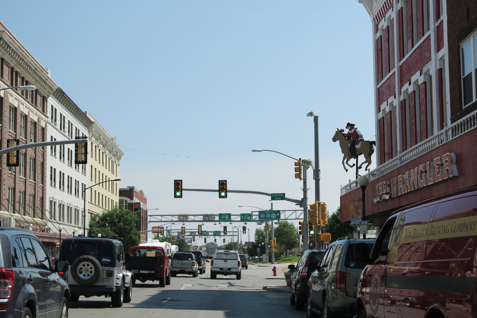
Between Carey Avenue and Capitol Avenue, eastbound Business Loop I-80 and U.S. 30 (Lincolnway) pass by The Wrangler, a historic building that is immediately recognizable by visitors to Cheyenne Depot Plaza, which is anchored by the historic depot. Photo taken 08/15/13. |
|
After the Capitol Avenue intersection, the next intersection along eastbound Business Loop I-80 and U.S. 30 (Lincolnway) is with Central Avenue, which carries Interstate 180, U.S. 85, Business Loop I-25, and Business U.S. 87 south. The signs here were replaced in 2008, and the newer signs deemphasized and removed references to Business U.S. 87. Photo taken 08/15/13. |
|
|
Back in 2005, eastbound Business Loop I-80 and U.S. 30 (Lincolnway) approached the intersection with Interstate 180, U.S. 85, Business Loop I-25, and U.S. 87 Business (Central Avenue) south to Greeley. At this point, Central Avenue travels one-way southbound. The portion of Central Avenue between Lincolnway and Interstate 80 is designated as Interstate 180, even though this portion of Central Avenue does not meet Interstate standards (there are traffic signals along Interstate 180, which has no freeway segment). Photo taken 09/06/05. |
|
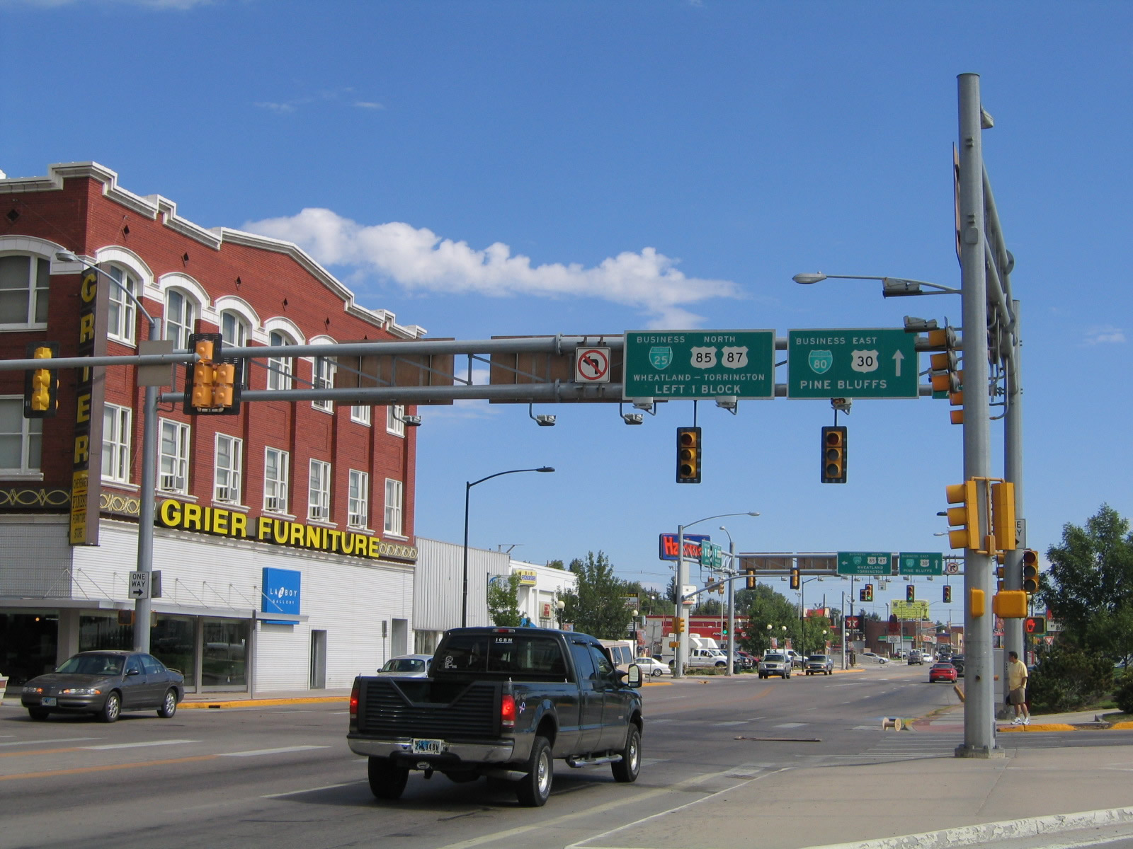
Eastbound Business Loop I-80 and U.S. 30 (Lincolnway) next meets Central Avenue (Interstate 180, U.S. 85, Business Loop I-25, and Business U.S. 87), which travels one way southbound. The signs here were replaced in 2008, and the newer signs deemphasized and removed references to Business U.S. 87. Control cities were also removed from the overhead signs. The next left connects to Warren Avenue (U.S. 85, Business Loop I-25, and Business U.S. 87), which travels one way northbound. Photo taken 08/15/13. |
|
|
Back in 2005, we see the older overhead signs at the Central Avenue intersection. An oddity is that Central Avenue carries four signed routes along this stretch: Interstate 180, U.S. 85, Business Loop I-25, and Business U.S. 87. While four signed routes on one segment of roadway is not unheard of nationwide (or even in Wyoming), this is the only known roadway signed with an Interstate, Off-Interstate Business Loop, U.S. route, and Business U.S. route. The four routes remain merged over Central Avenue until they meet Interstate 80. U.S. 85 continues south from there toward Greeley, Colorado, while Business Loop I-25 and Business U.S. 87 return to Interstate 25/U.S. 87 via College Drive (Wyoming 212). Immediately after the ramp to southbound Interstate 180, Business Loop I-25, U.S. 85, and U.S. 87 Business (Central Avenue), we see overhead signs for U.S. 85, Business U.S. 87, and Business Loop I-25/Warren Avenue north, which is the next block after Central Avenue. Photos taken 09/06/05. |
|
|
Eastbound Business Loop I-80 and U.S. 30 (Lincolnway) next meets Warren Avenue (U.S. 85, Business Loop I-25, and Business U.S. 87), which travels one way northbound. As noted earlier, the signs here were replaced in 2008, and the newer signs deemphasized and removed references to Business U.S. 87. Control cities were also removed from the overhead signs. Ahead, Lincolnway proceeds east out of the downtown area. Photos taken 08/15/13. |
|
|
Back in 2005, eastbound Business Loop I-80 and U.S. 30 (Lincolnway) meet northbound U.S. 85, Business U.S. 87, and Business Loop I-25/Warren Avenue. The business route follows the Central Avenue and Warren Avenue one-way couplet for several blocks, then reunite north of Eighth Avenueto become Central Avenue once again. Central Avenue remains the business loop designation until the three routes meet Interstate 25 at Exit 12. Photos taken 09/06/05. |
|
|
This is the first reassurance shield for eastbound Business Loop I-80 and U.S. 30 (Lincolnway) after the intersection with Central Avenue southbound (Interstate 180) and Warren Avenue northbound (U.S. 85). These shields were replaced in 2010 as noted by the date code at the bottom of the route markers. Photos taken 08/15/13 and 09/06/05. |
|
The next signalized intersection along eastbound Business Loop I-80 and U.S. 30 (Lincolnway) is with Evans Avenue. Photo taken 08/15/13. |
|
Skipping ahead and now past Logan Avenue, the signage for Business Loop I-80 shifts to "To Interstate 80." Logan Avenue connects to the Norris Viaduct, which crosses over the Union Pacific Railroad to enter south Cheyenne; this is the third crossing (the other two are Ames Avenue and Interstate 180). Logan Avenue angles northwest to southeast, like the downtown streets. East of Logan Avenue, however, all roads are north-south or east-west on a traditional grid pattern. Photo taken 09/06/05. |
|
Eastbound Business Loop I-80 & U.S. 30 (Lincolnway) approach Converse Avenue shortly after Logan Avenue. Photo taken 09/06/05. |
|
Business Loop I-80 is signed as "To Interstate 80," which is commonly found on all business loops in Wyoming after passing through the city center. However, Business U.S. 30 is erroneously signed, since this is not the business route for U.S. 30; it is the mainline. Photo taken 09/06/05. |
|
Three blocks east of Converse Avenue is a traffic signal for Hot Springs Avenue. This is a less significant street as it primarily serves residential rather than through traffic. Photo taken 09/06/05. |
|
Lincolnway continues to widen out, and there is a substantial right of way that separates the road from the adjacent houses (including a frontage road system on both sides of the highway). Photo taken 09/06/05. |
|
Ridge Road is another north-south road in the grid system that is prevalent between Logan Avenue and College Drive. It serves residential and commercial access. Photo taken 09/06/05. |
|
The next major intersection is College Drive, and this is where the routes divide. Business Loop I-80 turns south on College Drive (Wyoming 212) to rejoin Interstate 80; U.S. 30 continues straight ahead on Lincolnway toward Archer. U.S. 30 will rejoin Interstate 80 at Archer. Photo taken 09/06/05. |
|
The short section of U.S. 30 that is extant east of College Drive is fairly short; there were proposals in the 1960s to route Interstate 80 directly over Interstate 80 east of College Drive, but those proposals never came to pass. Photo taken 09/06/05. |
| Business Loop I-80 east & Wyoming 212 south |
|
Now south of Lincolnway, Business Loop I-80 travels south along with Wyoming 212 on College Drive. There are only one intersection between Lincolnway and Interstate 80, and the main intersection north of the railroad tracks is here at 12th Street. Use 12th Street west to Nationway, which passes the oil refinery and connects to the Norris Viaduct and Logan Avenue. Photo taken 09/06/05. |
|
After the 12th Street (Nationway) intersection, Business Loop Interstate 80 and Wyoming 212 continue south toward the junction with Interstate 80. There are no more intersections along this expressway; the upcoming viaduct crosses not only the Union Pacific Railroad but also Campstool Road, a frontage road to Interstate 80. There are no services north of Interstate 80 at the Wyoming 212 interchange. Photo taken 09/06/05. |
|
Like many smaller guide signs, this sign shows Interstate 80 with the state name within the shield. Here, College Drive crosses over Campstool Road and the railroad. Photo taken 09/06/05. |
|
Southbound Wyoming 212 and eastbound Business Loop I-80 meet Interstate 80 at this interchange. This marks the eastern terminus of Business Loop I-80. Photo taken 09/06/05. |
| Business Loop I-80 west & Wyoming 212 north |
|
Northbound Wyoming 212 (College Drive) approaches the ramp to westbound Interstate 80 to Laramie. Photo taken 09/06/05. |
|
Continuing north along Business Loop I-80 and Wyoming 212, the College Drive expressway meets 12th Street, which travels west to Nationway and the Norris Viaduct. Note that the pull through signage here omits Wyoming 212 and College Drive. Photo taken 09/06/05. |
|
Westbound Business Loop I-80 and northbound Wyoming 212 (College Drive) approaches their junction with U.S. 30 (Lincolnway). At this intersection, Business Loop I-80 turns west (left) with U.S. 30 toward downtown Cheyenne. U.S. 30 also continues east (right) from this intersection, leading toward Archer, where it rejoins Eastbound Interstate 80. Wyoming 212 continues northerly along College Drive from this point. Photo taken 09/06/05. |
|
Here, northbound College Drive meets Lincolnway. Turn left (west) onto Lincolnway to follow Business Loop I-80 and U.S. 30 to downtown Cheyenne. Turn right to follow Lincolnway to east Cheyenne and Archer. Continue straight ahead to follow College Drive (Wyoming 212) to Dell Range and northern Cheyenne. Wyoming 212 eventually curves toward the west to meet Wyoming 219/Yellowstone Road in northern Cheyenne. Photo taken 09/06/05. |
| Business Loop I-80 & U.S. 30 west |
|---|
|
Skipping ahead, Business Loop I-80 and U.S. 30 west approach Downtown Cheyenne. The signage visible ahead is for the junction with Interstate 180, U.S. 85, Business U.S. 87, and Business Loop I-25 (Warren Avenue and Central Avenue one-way couplet). Photo taken 08/15/13. |
|
|
Westbound Business Loop I-80 and U.S. 30 approach the junction with Interstate 180, U.S. 85, Business U.S. 87, and Business Loop I-25 (Warren Avenue). The Central Avenue/Warren Avenue couplet is the original alignment of the main north-south corridor through Cheyenne. The Central Avenue/Warren Avenue couplet to the north leads to the State Capitol, a variety of state government buildings, and the commercial strip located along Dell Range Boulevard toward the north end of Cheyenne. Along this couplet north of Lincolnway, the northbound business loop follows Warren Avenue, and the southbound business loop follows Central Avenue. Photos taken 08/15/13 and 08/02/10. |
|
|
Looking back to 2005, we see Business Loop I-80 and U.S. 30 approach the junction with Interstate 180, U.S. 85, Business U.S. 87, and Business Loop I-25 (Warren Avenue) with signage that included destination and control cities. This signalized intersection marks the northern terminus of Interstate 180; proceed ahead for U.S. 30 and Business Loop I-80 west along Lincolnway. Photos taken 09/06/05. |
|
Westbound Business Loop I-80 and U.S. 30 meet Warren Avenue at this traffic signal. One block ahead is the left turn for Central Avenue south (U.S. 85 and Interstate 180). Photo taken 08/15/13. |
|
Business Loop I-80 and U.S. 30 enter the historic Downtown district of Cheyenne. Photo taken 08/15/13. |
|
One block further west of Warren Avenue, Business Loop I-80 and U.S. 30 (Lincolnway) now approach the intersection with Central Avenue, which connects to Interstate 180, U.S. 85, Business U.S. 87, and Business Loop I-25 south. These signs were installed in 2008. Photo taken 08/15/13. |
|
|
Back in 2005, westbound Business Loop I-80 and U.S. 30 (Lincolnway) meet their junction with Interstate 180, Business Loop I-25, U.S. 85, and Business U.S. 87 south. Central Avenue to the south is the Interstate 180 viaduct over the railroad yard. Photos taken 09/06/05. |
|
Between Central Avenue and Capitol Avenue, westbound Business Loop I-80 and U.S. 30 (Lincolnway) pass Cheyenne Depot Plaza on the south side of the road. The Wrangler, a local landmark, comes into view along the west side of Capitol Avenue. Photo taken 08/15/13. |
|
Westbound Business Loop I-80 and U.S. 30 next intersect with Capitol Avenue, which travels north toward the state capitol. Turn left here for the west side of the Cheyenne Depot Plaza. Photo taken 08/15/13. |
|
Westbound Business Loop I-80 and U.S. 30 reaches Carey Avenue to F.E. Warren Air Force Base via Randall Avenue, which angles northwest toward F.E. Warren Air Force Base, crossing Interstate 25 at the Pershing Boulevard interchange.. Photo taken 09/06/05. |
|
Westbound Business Loop I-80 and U.S. 30 reaches Pioneer Avenue by the refurbished Dinneen building at the northwestern corner. Photo taken 08/15/13. |
|
Lincolnway passes by the Dinneen building just west of Pioneer Avenue. Photo taken 08/15/13. |
|
U.S. 30 is signed alone, with a To Interstate 25 and To Interstate 80 shield assembly posted immediately thereafter. The next intersection is with Bent Avenue. Photo taken 09/06/05. |
|
Still looking at the Bent Avenue intersection a few years later (2013) near the headquarters of the Wyoming Tribune-Eagle newspaper, we see a To Interstate 25 and To Interstate 80 signed shield assembly along westbound Lincolnway; the U.S. 30 shield shown in 2005 had gone missing. Photo taken 08/15/13. |
|
Here is an overview of the commercial corridor along westbound Lincolnway near Snyder Avenue. Photo taken 08/15/13. |
|
Westbound Business Loop I-80 and U.S. 30 (Lincolnway) connect with Ames Avenue, which travels north under a viaduct to serve southern Cheyenne. Photo taken 09/06/05. |
|
Westbound Business Loop I-80 and U.S. 30 meet Missile Drive. Follow Missile Drive west to F.E. Warren Air Force Base and Wyoming 210/Happy Jack Road, which travels west to Curt Gowdy State Park and the Pole Mountain area. Happy Jack Road offers an alternative route between Cheyenne and Laramie via a scenic two-lane road to Sherman Hill and Vedauwoo. Photo taken 09/06/05. |
|
After the Missile Drive intersection is this Business Loop I-80 and U.S. 30 shield assembly. Photo taken 08/15/13. |
|
|
This viaduct with a steel truss bridge carries the Burlington Northern and Santa Fe Railroad over Lincolnway (Business Loop I-80 and U.S. 30). Photos taken 09/06/05. |
|
These shields are posted on westbound Lincolnway prior to the Burlington Northern Railroad overpass. Photo taken 08/15/13. |
|
Prior to passing under the Burlington Northern and Santa Fe Railroad viaduct, a small guide sign points the way to Westland Road (right turn). Photo taken 08/15/13. |
|
Continuing west, Business Loop I-80 and U.S. 30 reach Southwest Drive south and Cutler Road north. Photo taken 09/06/05. |
|
Westbound Business Loop I-80 and U.S. 30 (Lincolnway) approach Fleischli Parkway, which serves the Home Depot, truck stops, and hotels on the north side of the Lincolnway. Fleischli Parkway is not a through street. Photo taken 09/06/05. |
|
|
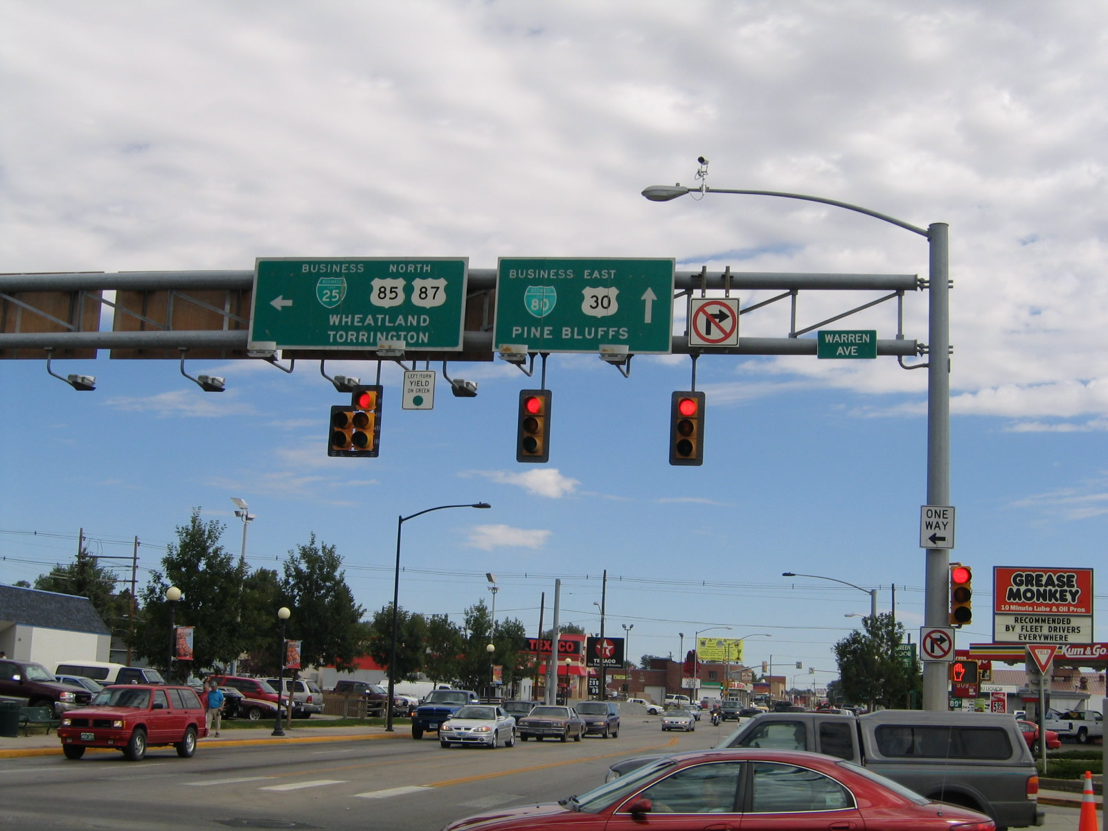
Westbound Business Loop I-80 and U.S. 30 (Lincolnway) approach the junction with Interstate 25 and Interstate 80. The first ramp connects to northbound Interstate 25/U.S. 87 to Casper, while the second ramp (loop ramp) connects to southbound Interstate 25/U.S. 87 to eastbound Interstate 80. Continue straight ahead to Interstate 80 west to Laramie and Wyoming 225, Otto Road. The overhead sign bridge shown in 2005 was removed from service by 2011, most likely when the median island was improved with streetscape and plantings. Photos taken 08/11/14 and 09/06/05. |
|
A ramp connects westbound Business Loop I-80 and U.S. 30 (Lincolnway) with Interstate 25 and U.S. 87 north to Casper. Photo taken 08/11/14. |
|
|
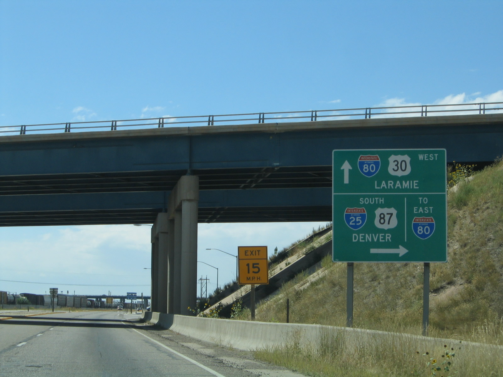
Passing under Interstate 25, another guide sign advises of the pending ramp to Interstate 25 and U.S. 87 south to Fort Collins and Denver. Business Loop I-80 and U.S. 30 continue west to rejoin Interstate 80 after passing by Little America. Note the changes in this sign including revised control cities and removal of the state name from the Interstate shields. Photos taken 08/11/14 and 09/06/05. |
|
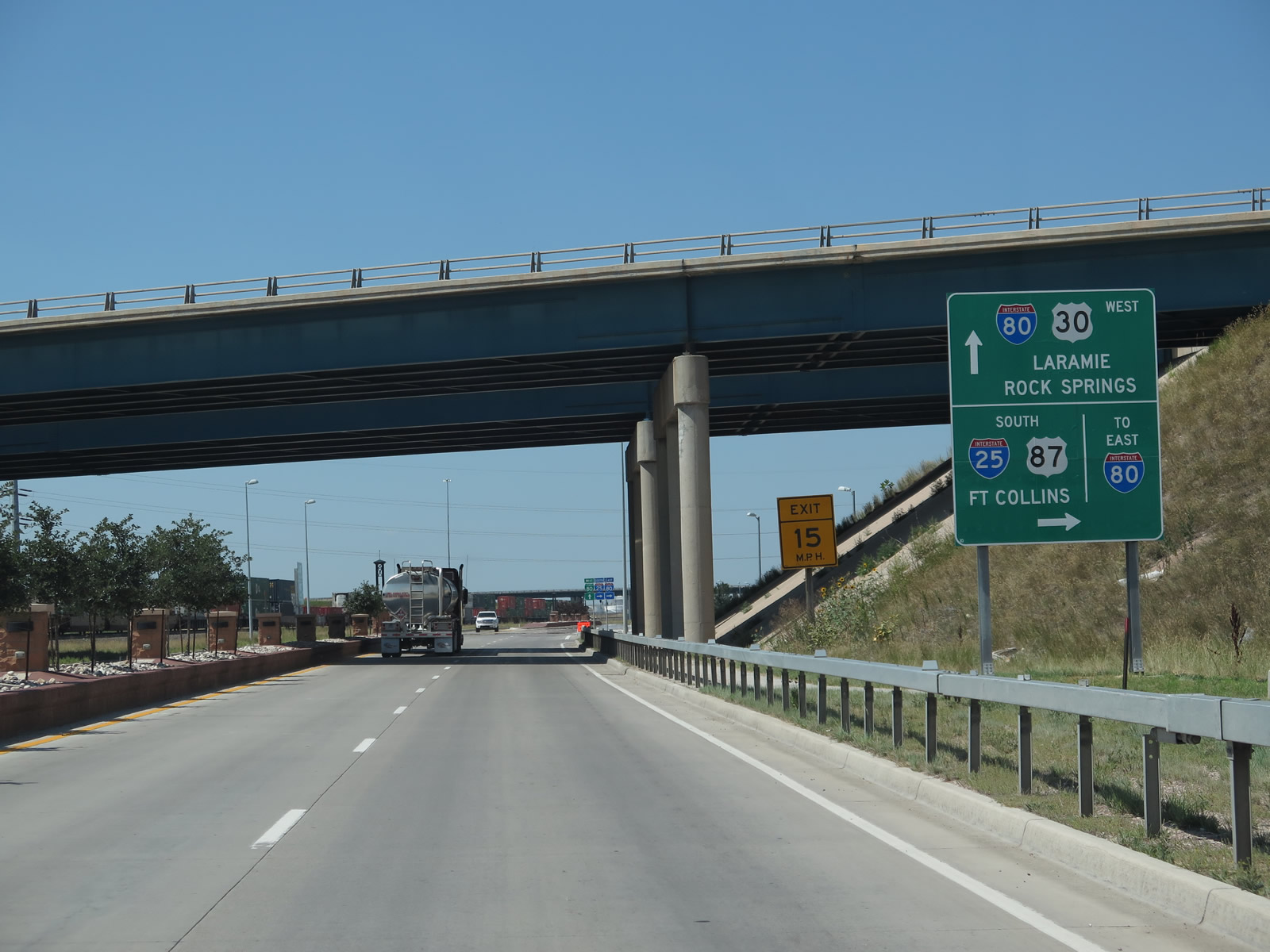
Turn right here for the connection from Business Loop I-80 and U.S. 30 west to Interstate 25 and U.S. 87 south to Fort Collins and Denver. Proceed ahead for Interstate 80 and U.S. 30 west to Laramie and Rock Springs. Continue straight ahead on Lincolnway to Interstate 80 (and Wyoming 225 (Otto Road)). Photo taken 08/11/14. |
|
Leaving the intersection with the ramp to Interstate 25 and U.S. 87 north and passing by Little America, we see another section of improved median followed by the final westbound reassurance shield of Business Loop I-80 before we reach the junction with Interstate 80. The overpass ahead carries Interstate 25 over the business route. This reassurance shield assembly was gone by 2014. Photo taken 08/15/13. |
|
A double circuit 230kV power line crosses over West Lincolnway near the entrance to Little America, a resort hotel and golf complex squeezed between Interstate 80 on the west and Interstate 25 on the east. Photo taken 08/11/14. |
|
Prior to the installation of the taller, double circuit power line tower, two separate H-frame style poles carried wires over West Lincolnway. Back in 2005, this Interstate 80 route marker shield indicated the direction for traffic continuing west on Interstate 80 and U.S. 30 toward Laramie, Rawlins, Rock Springs, and Salt Lake City. This shield assembly has since been removed. Photos taken 09/06/05. |
|
Westbound Business Loop I-80 and U.S. 30 meet Interstate 80 at Exit 358. Turn right here for Interstate 80 and U.S. 30 west to Laramie and Rock Springs. Continue straight ahead on Lincolnway to connect to Wyoming 225 (Otto Road); turn right to follow U.S. 30 onto Interstate 80 west at Exit 358. The business loop ends here. Wyoming 225 follows Old U.S. 30 and Historic Lincoln Highway; it rejoins Interstate 80 at Exit 348. Photo taken 08/11/14. |
|
There is no access from westbound West Lincolnway to eastbound Interstate 80. At this point, the offramp Interstate 80 east connects to Lincolnway. Ahead, Wyoming 225 begins along former U.S. 30 and historic Lincoln Highway. Photo taken 08/11/14. |
Page Updated August 30, 2014.