
Interstate 10 Florida – East

Guide signs for the diamond interchange (Exit 56) with SR 85 were replaced by 2009. 01/18/06

SR 85 forms a busy commuter route between Crestview and Eglin A.F.B. 07/22/04
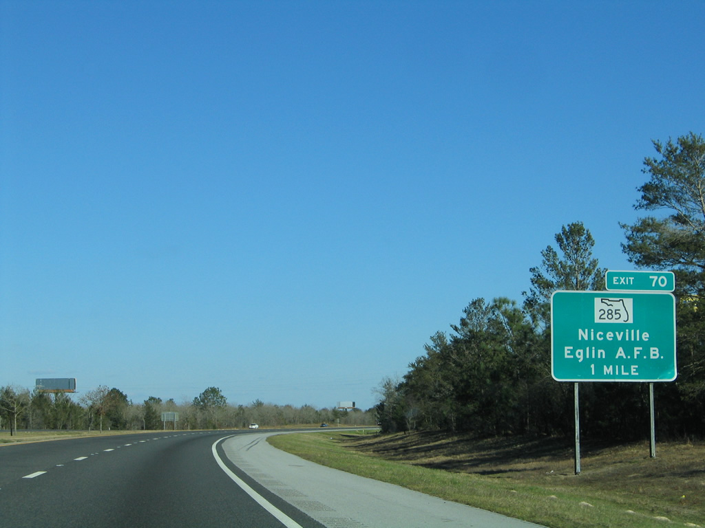
Interstate 10 approaches a diamond interchange (Exit 70) with SR 285 just east of the Walton County line. This sign was replaced by 2009. 02/12/06

This shield for U.S. 331 was removed at Exit 85 in DeFuniak Springs. 05/02/09

This mileage sign posted 116 miles west of Tallahassee was replaced by 2010. 09/01/08

Entering the rural diamond interchange (Exit 96) with SR 81 at Ponce De Leon on I-10 east. This sign was replaced by 2010. 02/12/06

Second sign change was made by 2014 for Exit 96. 05/27/10

The new guide signs for Exit 96 include a placard for the adjacent Rest Area along SR 81 south. 06/13/12

Interstate 10 continues seven miles to the northwestern corner of Washington County and CR 279 at Caryville. 09/28/10

1.25-mile guide sign for Exit 104 and CR 279 (Waits Avenue / Pate Pond Road). This sign was replaced by 2010 with a new one-mile assembly missing an exit tab. 02/12/06

The guide sign preceding Exit 112 to SR 79 at Bonifay was replaced by 2010. 07/19/07

All guide signs for Exit 130 (U.S. 231) along Interstate 10 eastbound were replaced by 2010. 07/22/04

U.S. 231 provides a direct route to the city of Dothan, Alabama from Interstate 10. 07/22/04

Exit 130 departs I-10 east for U.S. 231 north to nearby Cottondale and south to its terminus in Panama City. 07/22/04

I-10 angles southeast to bypass Marianna at the first of two exits for the Jackson County seat. 07/22/04

Signs for Exit 22 and SR 276 were replaced by 2010. SR 276 begins a 3.40 mile route to U.S. 90 in Marianna nearby at CR 167. 07/22/04

Nearing the Chipola River along I-10 east on the one mile approach to Exit 142 with Florida 71. Both guide signs for SR 71 were replaced by 2012. 07/22/04

A number of traveler services line SR 71 both south and north of Interstate 10 at Exit 142. 07/22/04

This mileage sign posted ten miles ahead of SR 69 (Exit 152) was replaced by 2008. 07/22/04

Signs for the rural diamond interchange (Exit 158) between Interstate 10 and Jackson County 286 were replaced after 2011. 02/21/10

Exit 158 leaves I-10 east for CR 286 north to Sneads. Sneads is a town along U.S. 90, just to the south of Lake Seminole. 11/24/10

Faded guide sign that was posted one mile ahead of the diamond interchange (Exit 166) with CR 270A in Gadsden County. 07/13/12

This sign posted at the off-ramp (Exit 166) for CR 270A predated the 2002 switch from sequential to mile based exit numbers in Florida. It remained in service until 2012. 07/13/12

Eight miles to the east is the next interchange of Interstate 10 with Florida 12 (Greensboro Highway). 07/13/12

An older style guide sign with a cutout shield for SR 267 was posted for Exit 181 on I-10 east until 2009. 07/22/04

Older guide signs for Exit 192 omitted any control cities for U.S. 90 at Midway. Quincy and Tallahassee were added to the replacement, which is located 0.25 miles further east. 08/07/06

Replaced signage for the parclo interchange (Exit 192) with U.S. 90 on Interstate 10 east at Midway. 08/07/06

Approaching Exit 196 with Capital Circle NW (SR 263) at the onset of a three-year widening project for Interstate 10 across northern Tallahassee. 06/11/06
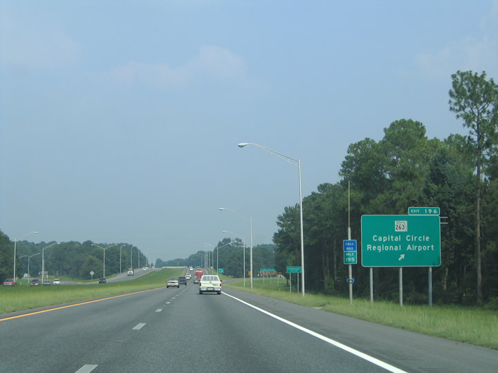
A sign replacement was made by 2006 for Exit 196, despite the impending expansion of Interstate 10 to six lanes. SR 263 forms the western half of Capital Circle, a surface beltway linking U.S. 27 near Lake Jackson to the north with Tallahassee Regional Airport (TLH) to the south. 07/22/04

A sign replacement was made by 2006 for Exit 196, despite the impending expansion of Interstate 10 to six lanes. SR 263 forms the western half of Capital Circle, a surface beltway linking U.S. 27 near Lake Jackson to the north with Tallahassee Regional Airport (TLH) to the south. 06/11/06

I-10 west at SR 263 (Capital Circle NW) during the Moving I-10 Forward project. 07/19/07

Sign changes in 2008 replaced Havana with Monroe Street for U.S. 27. This view looks at the pre-widened configuration of Interstate 10. 06/11/06

A look at the original four-lane freeway on the approach to Exit 199 and U.S. 27 (Monroe Street). Old Bainbridge Road spans the freeway in the distance. U.S. 27 provides the main route between Tallahassee and the cities of Bainbridge and Columbus, Georgia. 07/22/04

Entering the six ramp parclo interchange (Exit 199) with U.S. 27 on Interstate 10 east. 06/11/06

Leaving the Exit 199 interchange with U.S. 27 at the Lakeshore Drive under pass before the widening of Interstate 10 commenced. 07/22/04

What was the first guide sign for the then diamond interchange (Exit 203) with Florida 61 to U.S. 319 (Capital Circle NE) on I-10 east. 06/11/06

Exit 203 departed from I-10 east to Florida 61 (Thomasville Road). Raymond Diehl Road connects the ramp end with U.S. 319 (Capital Circle NE) nearby. Besides expansion of the off-ramp, the on-ramp to I-10 east was adjusted to better serve traffic from U.S. 319 headed toward Lake City. 06/11/06

Looking at former span wire supported guide signs on Exit 203 for SR 61 and U.S. 319. Traffic to U.S. 319 northbound is directed onto Thomasville Road north for its merge with U.S. 319 nearby. South bound U.S. 319 motorists should continue straight on Raymond Diehl Road for its intersection with Capital Circle NE. 07/22/04

All signs for upcoming Exit 209 with U.S. 90 east of Tallahassee were replaced in 2008. 07/22/04

Interstate 10 spans Miccosukee Road (CR 0347) on the one mile approach to Exits 209A/B with U.S. 90. 06/11/06
Photos by AARoads
Page Updated Friday January 24, 2025.