
State Route 241
California 241 is the Foothill Transportation Corridor and Eastern Transportation Corridor in Orange County, starting at Oso Parkway in Rancho Santa Margarita northwest of Coto de Caza and north of Ladera Ranch. The Foothill Transportation Corridor segment extends from Oso Parkway north to the California 133 interchange. From there north, California 241 is designated as the Eastern Transportation Corridor. California 241 continues from the California 133 interchange north to meet California 91 (Riverside Freeway) in the Santa Ana Canyon near Anaheim Hills.
California State Route 241 Guides
The Foothill Transportation Corridor and Eastern Transportation Corridor were among several freeway corridors first considered in the 1970s and developed as toll roads in the 1980s and 1990s. The four Orange County Toll Roads (California 241, California 73, California 133, and California 261) were constructed and are maintained by the Transportation Corridor Agencies (the two agencies are Foothill/Eastern Transportation Corridor Agency and the San Joaquin Hills Transportation Corridor Agency). Together, the agencies are typically referred to as the TCA).
The transportation corridors were named that because county planners were not sure in the late 1970s and early 1980s as to whether they would be built as arterials, expressways, or freeways. With traditional financing options becoming scarce, the Orange County toll road system is the largest such network in the state of California. Tolls were not used on freeways except on toll bridges (such as those found in the Bay Area). That changed in the 1980s. According to the official TCA webpage, "In 1987, Senate Bill 1413 passed, giving TCA the authority to construct the new roads as toll facilities and issue bonds backed by future toll revenues and development impact fees."
Through the 1990s, construction of the various segments of the toll road network began. The following list provides the key planning and opening dates for various segments of the Orange County toll road system:1
- 1976 - three transportation corridors (241/Foothill, 133-241-261/Eastern, and 73/San Joaquin Hills) appears in the Southeast Orange County Circulation Study
- 1981 - Orange County's Master Plan of Arterial Highways includes future routes of California 241 and California 261
- 1986 - The Transportation Corridor Agencies (TCA) -- which includes the Foothill/Eastern Transportation Corridor Agency and the San Joaquin Hills Transportation Corridor Agency -- are created, with Board of Directors approved
- 1987 - Senate Bill 1413 is approved, which allows the various transportation corridors to be built using toll funds
- 1993 - The first three-mile segment of California 241 (Foothill Transportation Corridor) opened near Portola Parkway
- 1998 - The next segment of the toll road network, including the north end of the Foothill Transportation Corridor and two major Eastern Transportation Corridor segments, opened: California 133 from Interstate 5 (Santa Ana Freeway) northeast to California 241 and California 241 from Portola Parkway north past California 133 to California 91 (Riverside Freeway)
- 1999 - The third segment of California 241 (Foothill Transportation Corridor) (three miles) opened from Antonio Parkway south to Oso Parkway
- 1999 - California 261 opened from Interstate 5/Jamboree Road to California 241
- 2000 - Process begins to select an alternative for extension of 241 south to San Onofre; six are chosen for consideration
- 2002 - one lane added to segments of California 241 north; this was the first project to add lanes to any of the toll roads
- 2005 - additional lanes are added to California 133 in a second widening project
- 2006 - TCA identifies finalist alignment for California 241/Foothill South extension
- 2007 - Selected alignment for Foothill South ignites controversy as various groups protest selection of route due to community, environmental, and related considerations
- 2008 - After multiple public hearings (including on with the California Coastal Commission), the 16-mile Foothill South alignment is rejected by both the Coastal Commission (February 6, 2008) and the U.S. Department of Commerce (December 18, 2008)2
- 2010 - TCA continues to look at traffic management alternatives to building the Foothill South extension, including looking at possible expansion of Interstate 5 in lieu of building the once-proposed freeway
Planning of the toll road network included assignment of route numbers into the state Streets and Highways Code in the 1980s and 1990s. The original route numbering for the transportation corridors was modified prior to the opening of the Eastern Transportation Corridor, while originally was assigned one route number (California 231). At that time, California 241 was conceived as forming only the Foothill Transportation Corridor between Interstate 5 near Cristianitos Road in San Diego County near San Onofre Beach north to the California 231 (now California 133)/Eastern Transportation Corridor interchange. At that time, California 231 was to be the designation assigned to the Eastern Transportation Corridor in planning stages. With the common junction between California 133, Interstate 5, and California 231, it was decided to extend the California 133 designation to California 241, then extend California 241 over former California 231 all the way to California 91. As a result of these changes, California 231 is not currently in use as a state route designation.
Foothill South Corridor
The controversy surrounding the Foothill South segment warrants a bit more discussion. Foothill South would have continued California 241 south from the Oso Parkway interchange to California 74 (Ortega Highway), then proceed into San Diego County through San Onofre State Beach adjacent to San Mateo Creek. Most who opposed the Foothill South project especially protested the notion of running a freeway through a state park; the proposed interchange between Interstate 5 and California 241 would have been near the famous Trestles surfing break. Fear that the freeway would destroy campgrounds, the surfing area, and surrounding park brought forward a defining coalition of many groups to oppose the Foothill South. Contentious hearings in 2008 brought both sides forward to present their respective cases, and a pair of key hearings with the California Coastal Commission and U.S. Department of Commerce resulted in the denial of the once-preferred Foothill South corridor. With that plan now dead, the TCA is now focusing on alternative routes that might avoid the state park or possibly expanding the Interstate 5 freeway. Development of lands off the California 74 corridor is anticipated, and this will eventually necessitate construction of additional transportation corridors to handle the increased traffic. As of 2010, it is unclear what the next step by TCA will be.
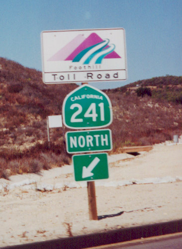
The Orange County Toll Roads generally use a different style of freeway entrance signage than most California freeways. This particular freeway entrance assembly, located along Oso Parkway (Exit 3), uses the standard Foothill Corridor logo in lieu of a freeway entrance sign. Also notice the slightly angular look to this California state shield. At the time this photo was taken, this was the first exit along northbound California 241; since then, the toll road has been extended south to Antonio Parkway. A further extension of the toll road to Interstate 5 near the Basilone Road exit in San Diego County is proposed, but it has encountered environmental and military opposition.
09/16/00
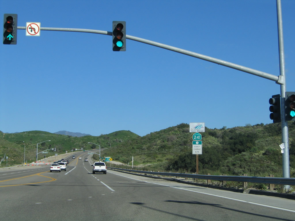
Eastbound Oso Parkway meets the off-ramp from California 241 (Foothill Transportation Corridor) south at this traffic signal. An on-ramp to California 241 north is the next left turn.
01/30/05
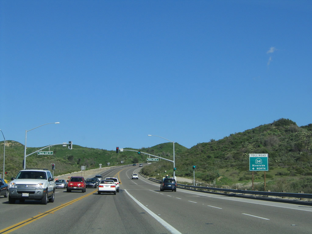
Shortly thereafter, eastbound Oso Parkway meets the on-ramp to California 241 (Foothill Transportation Corridor) north to Riverside. The assigned northbound control city is Riverside, as California 241 flows into California 91 in the Santa Ana Canyon. California 91 continues northeast from there toward Riverside.
01/30/05
References:
- The Orange County Register - Orange County Toll Roads Chronology. http://wiki.ocregister.com/Orange_County/Transportation/Toll_Roads
- Orange County Weekly Blog on California 241 by Matt Coker. http://blogs.ocweekly.com/navelgazing/241_toll_road/
- 241 / Windy Ridge Fire. http://cdfdata.fire.ca.gov/incidents/incidents_details_info?incident_id=168
Photo Credits:
- Andy Field: 09/16/00, 01/30/05
Connect with:
Page Updated Monday November 15, 2010.