Monthly Archives: August 2024

GIS Internship – Networking in Tampa

The GIS Internship part of the UWF GIS Certification program is something I have looked forward to since the start of classes last Fall. While working on AARoads is rewarding, the lack of a team to work with, especially in recent years, has been increasingly discouraging. Also my previous work with GIS Cartography and Publishing Services (GISCAPS) is 100% remote, so the interaction there is limited to phone calls. [...]

By |2024-11-11T15:34:30-05:00August 28th, 2024|GIS|Comments Off on GIS Internship – Networking in Tampa

Spatial Data Quality – Positional Accuracy of Road Networks

When viewing a map or working with geospatial data, it is generally assumed to be accurate. But this may not always be the case, and many factors can affect accuracy. Unaccounted bias may be present, data may have been digitized at a coarser scale than was required, errors present on a previous dataset used to update a new one could be carried over, etc. So how accurate is a [...]

By |2024-11-11T13:07:04-05:00August 28th, 2024|GIS|Comments Off on Spatial Data Quality – Positional Accuracy of Road Networks

Spatial Data Quality – Precision and Accuracy Metrics

The first module of Special Topics in GIScience covers aspects of spatial data quality. Furthermore, the associated lab defines and contrasts the concepts of accuracy and precision in spatial data. Quality generally represents a lack of error, where error in spatial data is the difference between a true value and an observed or predicted value. Rather than unrealistically attempting to know the exact error, an estimated error based upon sampling or another statistical [...]

By |2024-11-11T12:52:07-05:00August 24th, 2024|GIS|Comments Off on Spatial Data Quality – Precision and Accuracy Metrics

Corridor Suitability Analysis – Coronado National Forest

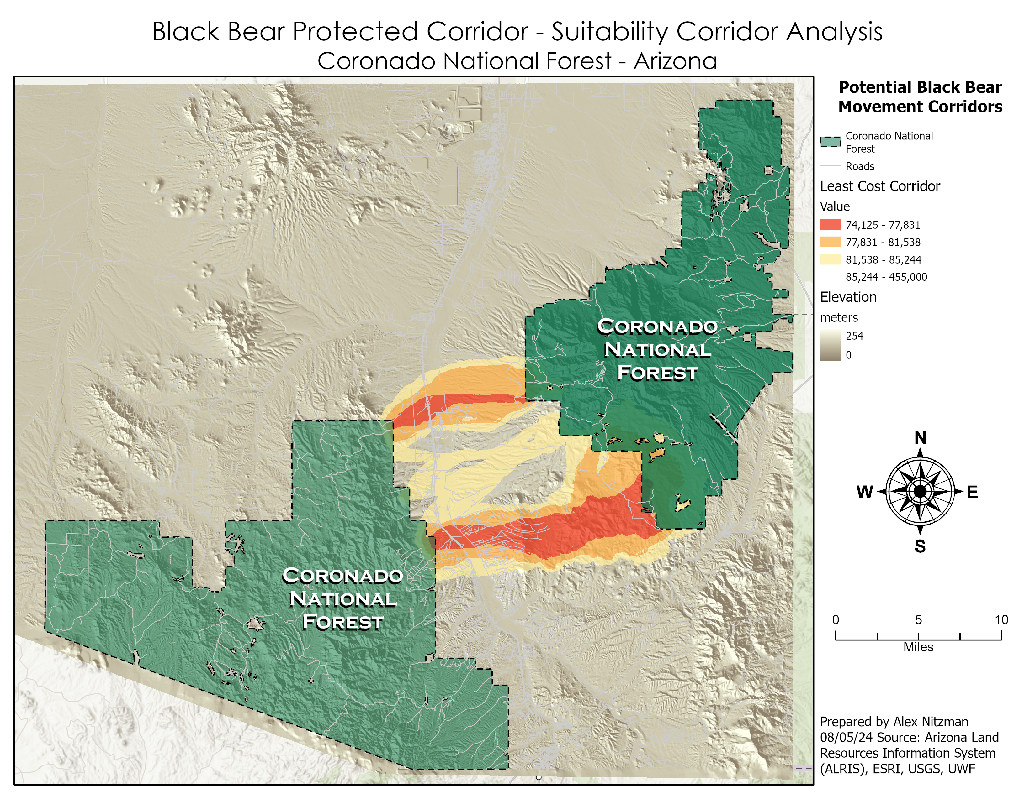
The final scenario for the lab of GIS Applications Module 6 is to determine a potential protected corridor linking two areas of black bear habitat in Arizona's Coronado National Forest. Data provided included the extent of the two existing areas of known black bear habitat, a DEM, a raster of land cover and a feature class of roads in the study area. Parameters required for a protected corridor facilitating [...]

By |2024-11-11T12:46:46-05:00August 5th, 2024|GIS|Comments Off on Corridor Suitability Analysis – Coronado National Forest

Least-Cost Path and Corridor Analysis with GIS

The second half of Module 6 for GIS Applications conducts Least-Cost Path and Corridor Analysis on two scenarios. The first continues working with the Jackson County, Oregon datasets from Scenario 2. There are several ways that GIS measures distance. Euclidean, the simplest, represents travel across a straight line or "as the crow flies". Manhattan distance simulates navigating along a city street grid, where travel is restricted to either north-south [...]

By |2024-11-11T12:35:32-05:00August 4th, 2024|GIS|Comments Off on Least-Cost Path and Corridor Analysis with GIS

Suitability Modeling with GIS

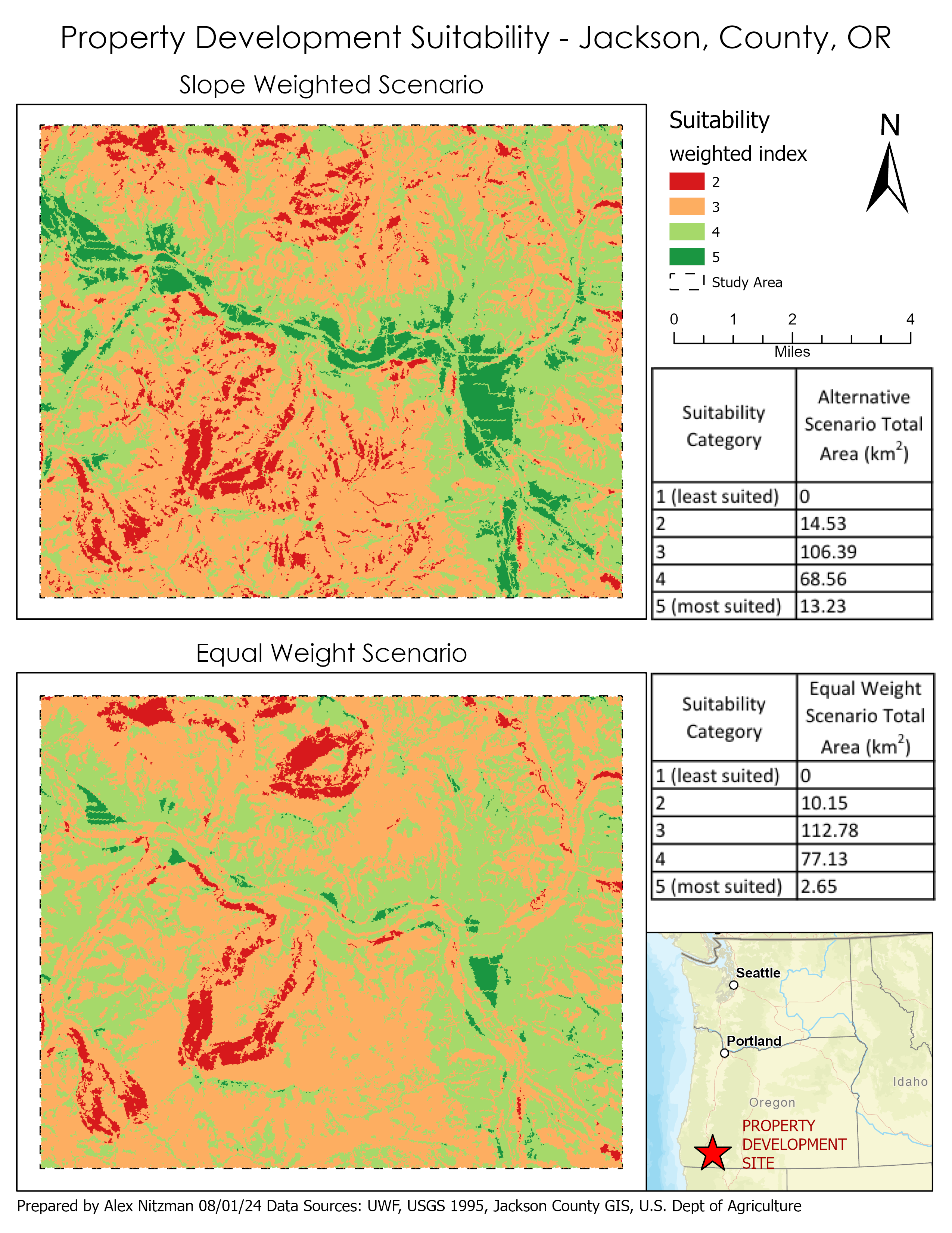
Module 6 for GIS Applications includes four scenarios conducting Suitability and Least-Cost Path and Corridor analysis. Suitability Modeling identifies the most suitable locations based upon a set of criteria. Corridor analysis compiles an array of all the least-cost paths solutions from a single source to all cells within a study area. For a given scenario, suitability modeling commences with identifying criteria that defines the most suitable locations. Parameters specifying [...]

By |2024-11-11T12:20:12-05:00August 1st, 2024|GIS|Comments Off on Suitability Modeling with GIS
Go to Top