
Someone once said (it was me) that a truly great world city has a few traits… great parks, beautiful landmarks, progressive people, and too-low-capacity freeways. This is true of Montreal as well, but what it might lack in freeway capacity in makes up for in sheer numbers of them. Here is a little look at some of the views around the city centre, and as always, click the pictures for larger versions.

A-20 east at A-10 and A-30
I love seeing “USA” as a control point. It would be neat to have more countries-as-control-points in my opinion.
“I-5 south, Sacramento/Mexico” – unlike what I saw further north in Quebec, the Trans-Canada highway is indeed signed here. Lets look at some other Montreal views…
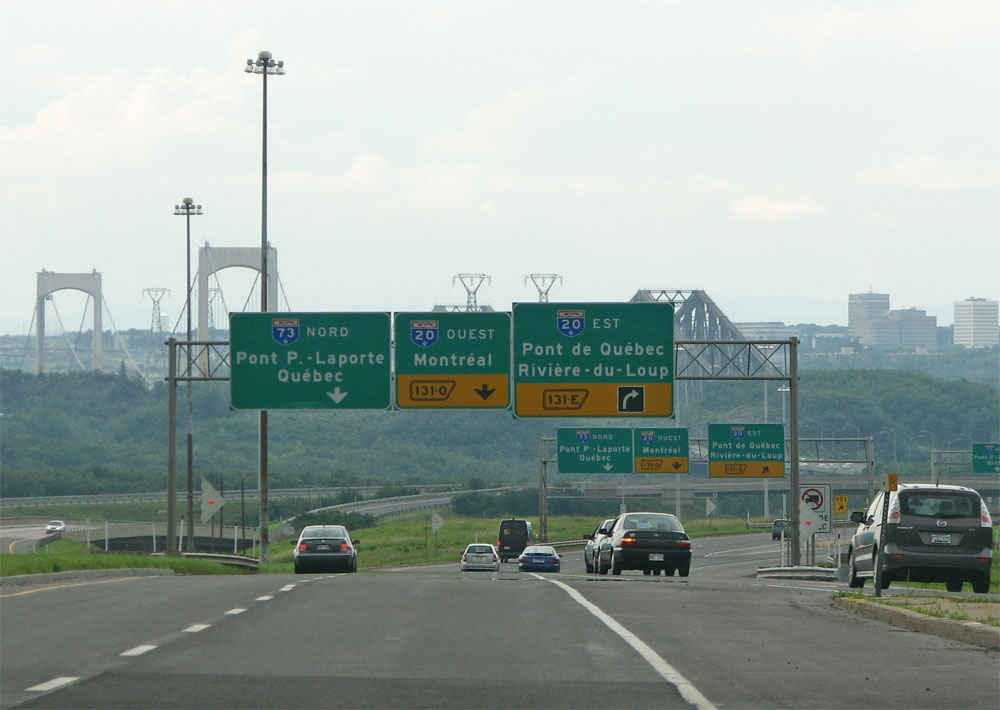
Montreal’s freeway system is based off of Quebec’s numbering scheme for its autoroutes. However all of the low numbers converge on Montreal because of its geographic location. So here you have A10 and A15 heading north into the city centre.

Here on a Thursday afternoon the traffic leaving the city on the southbound side is extremely heavy in the two lanes allotted. There is an HOV lane in the middle.

As with “USA” as a control point, the Interstates the Autoroutes connect to are widely used here on overhead signs. This view looks north on the A10/A15 near its junction with A20.
I find that bit of internationality pretty neat. I didn’t see a lot of NY so I don’t know if the Autoroutes are signed in the same fashion down there (are they?).

Signs like this one on the approach and entrances to Montreal Island indicate that right turns on red are prohibited here, this is for the safety of pedestrians.
None of the signs are English in any way, save for a few nord/north ouest/west signs I saw that looked really old. I find that interesting because in other places in Canada that I’ve been (Alberta, BC) there was quite a bit of bilingual signage. Much more so than the percentage of French speakers in those areas would warrant.

The A720 (The Ville Marie Autoroute) is a spur freeway that connects the A20 and A10 with the city centre.

The coolest aspect of this road is how it tunnels beneath the skyscrapers above. Its actually got aqequate lanes and it looks to have been recently resurfaced. It currently ends just before the Cartier bridge on the east/north side of the city centre but there are plans underway to have it continue further north as was originally planned.
Adieu!


Justin,
Love the Montreal road pics. Great job and thanks for sharing them!
Now if there was a website where you could track “clinched” Quebec Autoroutes just like the Interstate site… :)
Having been to a little of New York (only as far north as Glens Falls though), I can say that they do not sign Autoroute 15 as a control point on I-87 in Albany. There, they only use Montreal as a control city and that’s sadly it. So to answer the question in this blog of Autoroutes being signed in the same fashion…at least as of 2004, no.
There are a few Autoroute 15 trailblazers signed at interchanges in New York along Interstate 87. One is posted as far south as Warren County (home of Lake George). In Vermont, I believe we saw at least one Autoroute 55 trailblazer posted near the International border.
Hey! great pics, I live in Montreal and u could not do better to explain how Montreal was wonderfull Cya!
To add to Alex’s comment above, there are also a number of bilingual guide signs along the I-87 mainline (north- and southbound) for a number of exits into New York. The Montreal signs are the only ones I saw in Quebec on my trip through this area (July 2007) that were bilingual. It took a bit to get used to the change in language and messages/symbols upon crossing the border.
I love your site and all of the luscious photos!
Quick comment about the Quebec autoroute numbering scheme. Not all of the low numbers converge on Montreal. A5 goes north through Hull (the Gatineau region), a good couple hours west of Montreal.
The numbering order for the north-south autoroutes is fairly solidly obeyed, with the lowest (A5) in the west and the highest (A73 through Quebec City) in the east.
When they numbered the Autoroutes, they also developed a new numbering system for the non-expressways. If I recall correctly, routes 100-199 are the main highways around the province; routes 200-299 are secondary highways south (east) of the Saint Lawrence River and routes 300-399 are secondaries north (west) of the Saint Lawrence.
Keep up the great work, because there are plenty of us road geeks groovin’ on it!
Ancient post, but the reasoning for the bilingual signage on the Champlain Bridge and connecting roads is because they were built and continue to be maintained by the federal government. Consequently all signage is bilingual in accordance with the Official Languages Act.
You also see this on similar roads elsewhere, like inside Banff National Park in Alberta since the roads are federally maintained.
Roads done by the Quebec MTQ are generally unilingual French though extensive use is made of pictograms as is evident. The only bilingual sign that the MTQ uses typically is the “our signs are metric” and “radar detectors prohibited” at borders and the “Degel / Thaw” during the thaw period (load restrictions for trucks).