
I-20/59 North - Woodstock to Birmingham


Confirming markers for I-20/59 and U.S. 11/SR 5 posted ahead of mile marker 101 east of Rockview Lake.
06/06/17
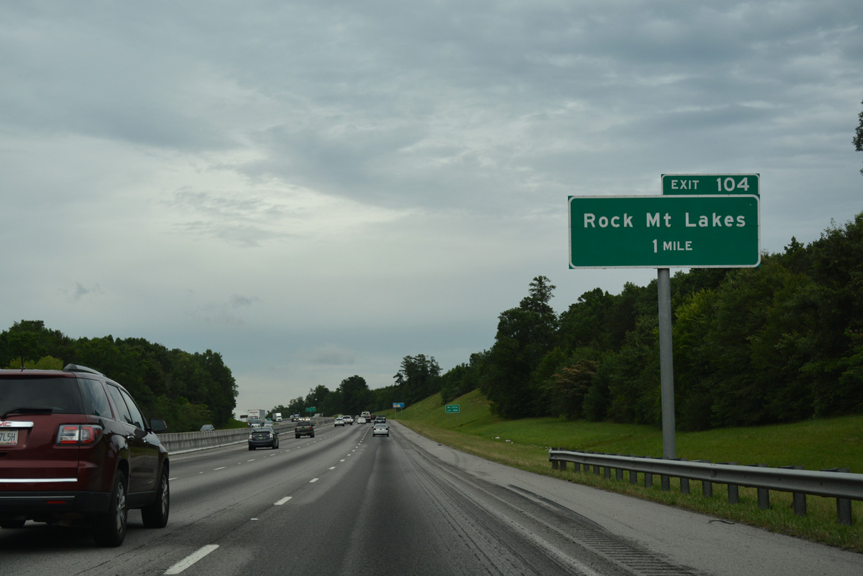
I-59/20 advance northeast between Red Ridge and Mc Ashan Mountain to Exit 104 for Mc Ashan Drive.
06/06/17
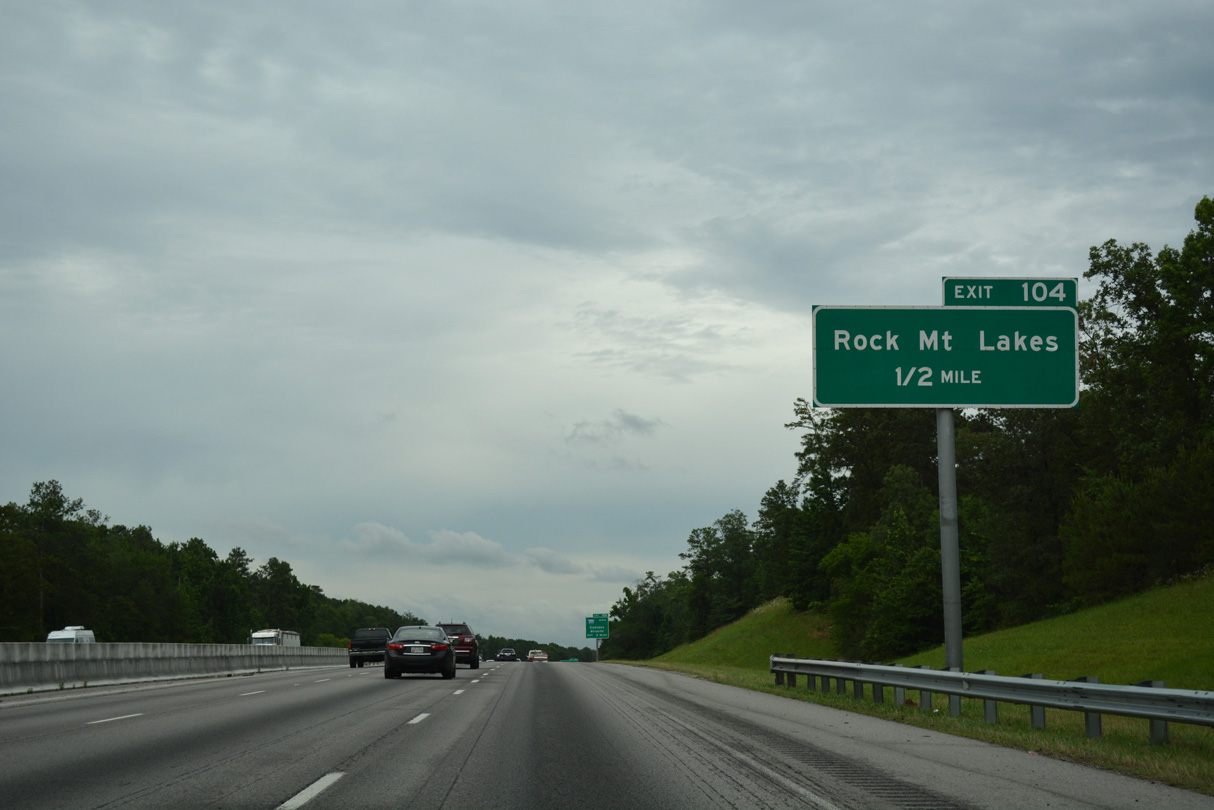
McAshan Drive connects I-59/20 with parallel Rock Mountain Lake Road to the west. South of Mc Ashan Mountain, McAshan Drive links with Old Tuscaloosa County northeast to McCalla.
06/06/17

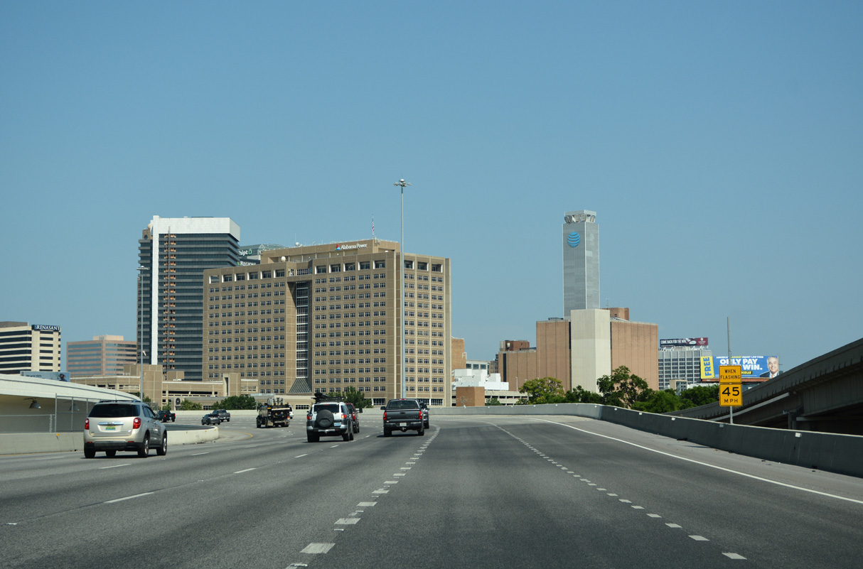
Interstate 459 branches east from I-59/20 at Exit 106 near McCalla. Constituting a suburban bypass of Birmingham, I-459 travels 33.64 miles northeast to I-59 at Trussville.
06/06/17

Collectively the Rock Lakes, Big Lake, Grantham Lake, and Ellis Lake lie west of Rock Mountain off Lakeside Drive. Lakeside Drive extends west from Rock Mountain Lake Road at Buddys Lane near Exit 104.
06/06/17
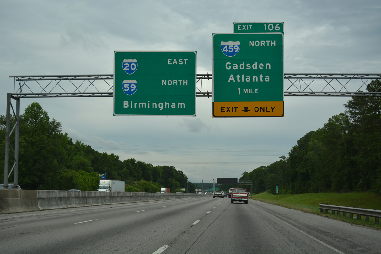
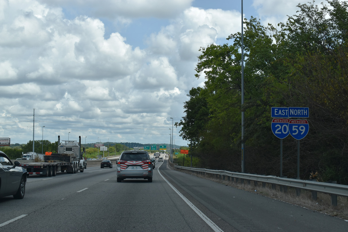
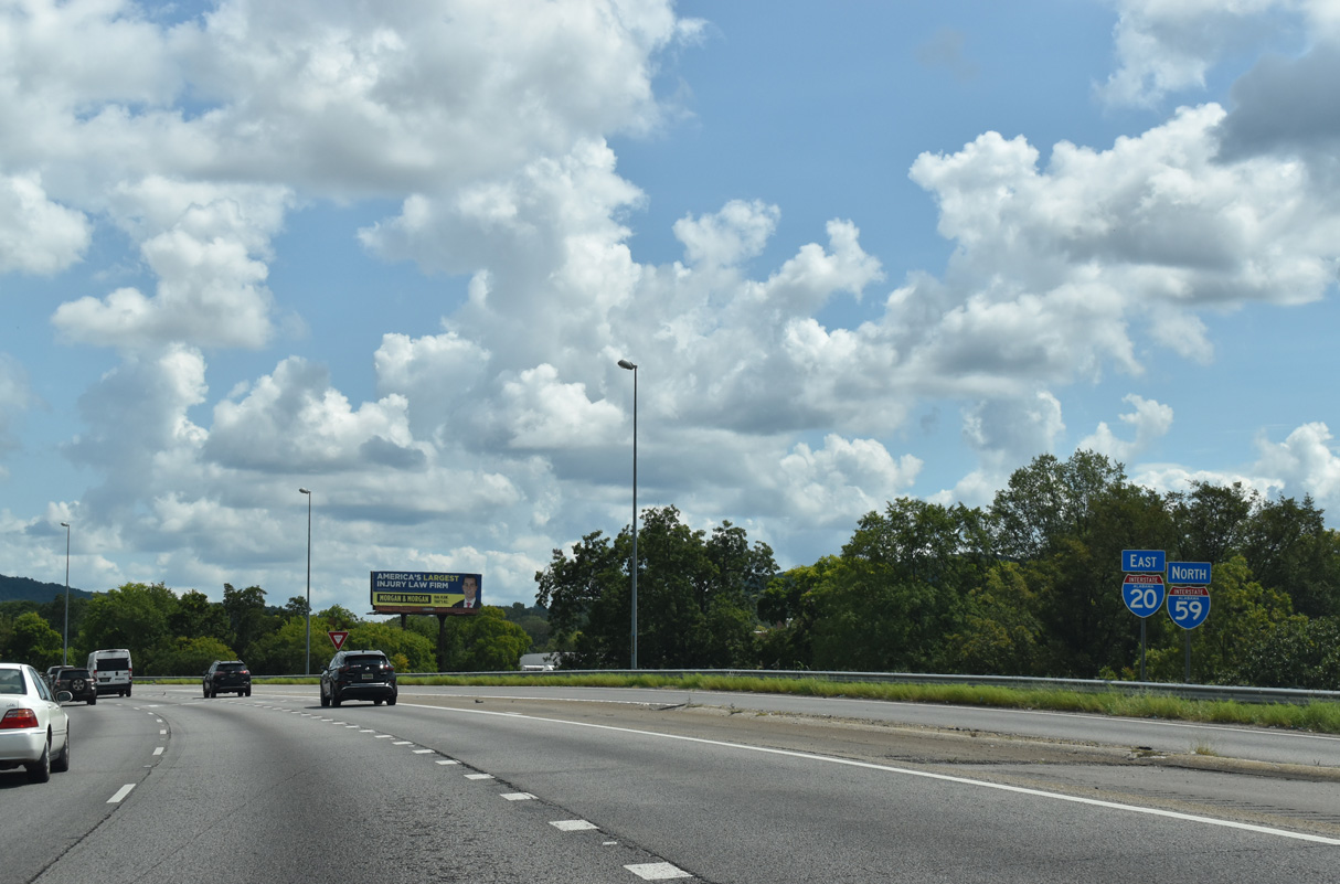
I-20/59 continue between Mc Ashan Mountain and Red Ridge northeast to the trumpet interchange (Exit 106) with Interstate 459.
06/06/17
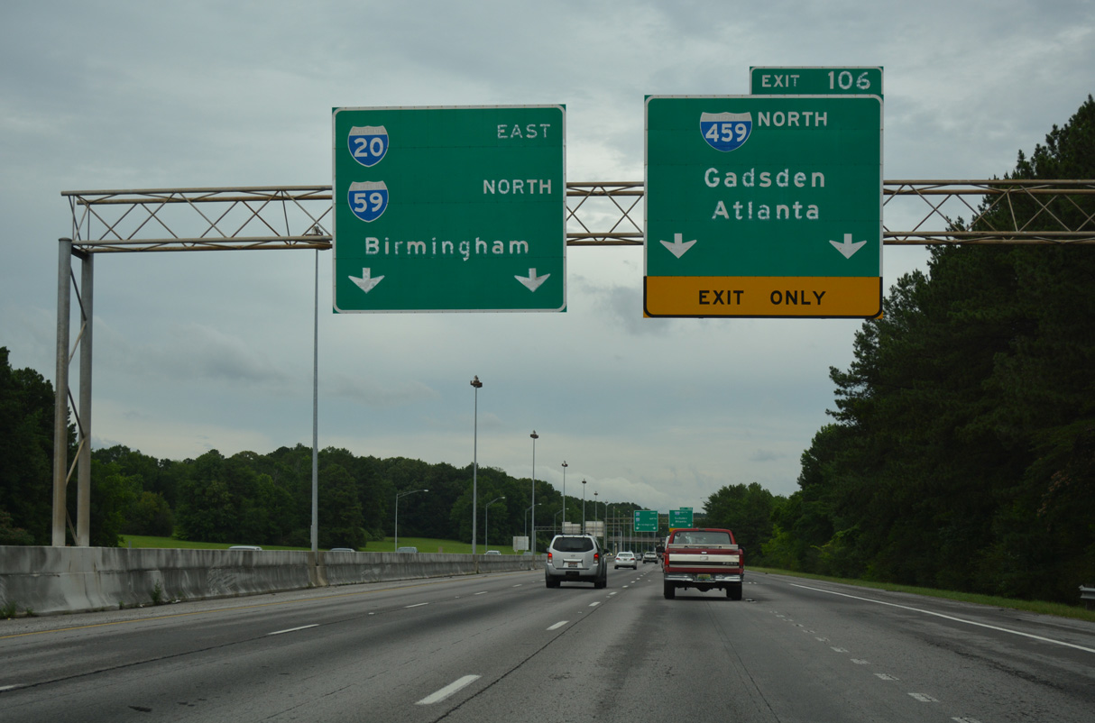
Connecting with I-20 east to Atlanta and I-59 north to Gadsden, the Interstate 459 bypass doubles as a commuter route for the suburbs of Hoover, Vestavia Hills and Irondale.
06/06/17
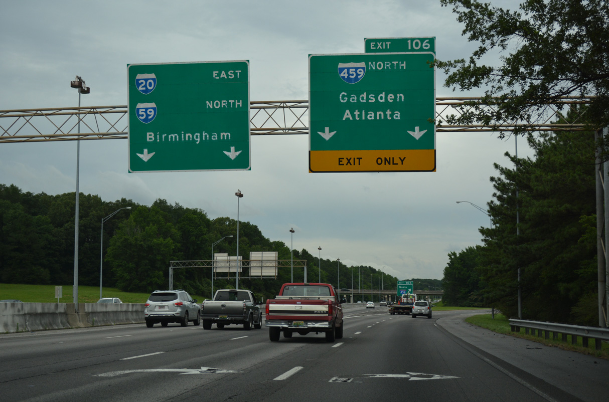
Two lanes separate at Exit 106 for I-459 northbound. Both I-59/20 and I-459 pass through the city of Bessemer on their respective routes. The succeeding exit from both freeways serves big box stores and other retail.
06/06/17

The Birmingham North Belt Line (Interstate 422) is proposed to meet I-20/59 at I-459 from Rock Mountain and Hueytown to the north.
06/07/17

I-20/59 continue northeast past McCalla and Flint Hill.
11/04/09
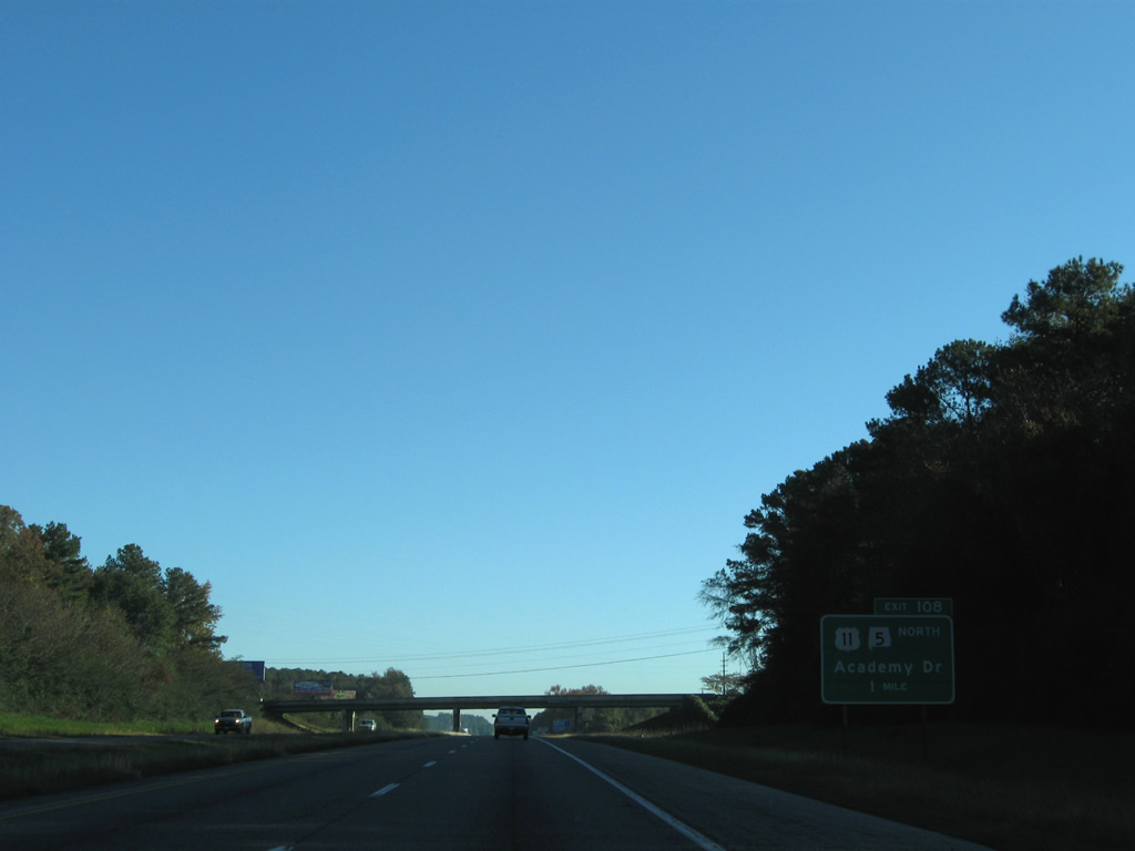
U.S. 11/SR 5 north part ways with I-59/20 north at a diamond interchange (Exit 108) with Academy Drive in one mile.
11/04/09

U.S. 11/SR 5 dog leg east from Exit 108 onto parallel 9th Avenue SW (Bessemer Super Highway) leading north to the Bessemer city center.
06/09/17

Exit 108 leaves I-20/59 north for Academy Drive and U.S. 11/SR 5 (9th Street SW) north.
06/09/17

Academy Drive extends west from I-20/59 to Powder Plant Road and east to 4th Avenue SW (CR 20).
06/06/17

U.S. 11/SR 5 parallel I-20/59 northeast along an arterial route through Bessemer to Brighton and Midfield.
06/06/17

A diamond interchange joins I-59/20 with Alabama Adventure Parkway at Exit 110 in one mile.
11/04/09

I-20/59 diverges northward from the commercial strip along adjacent U.S. 11/SR 5 (9th Avenue SW). U.S. 11 next meets I-20 and I-59 beyond their separation in northeast Birmingham.
11/04/09

Alabama Adventure Parkway runs west from I-20/59 to Alabama Adventure & Splash Adventure water park and Powder Plant Road. The arterial was originally named Visionland Parkway, as Visionland was the previous name of the theme park prior to 2012.
11/04/09
The succeeding two exits beyond Alabama Adventure Parkway also serve the city of Bessemer.
11/04/09

The exchange with Alabama Adventure Parkway opened to traffic on June 11, 2004. The arterial ties into U.S. 11/SR 5 a third of a mile east of Exit 110.
11/04/09

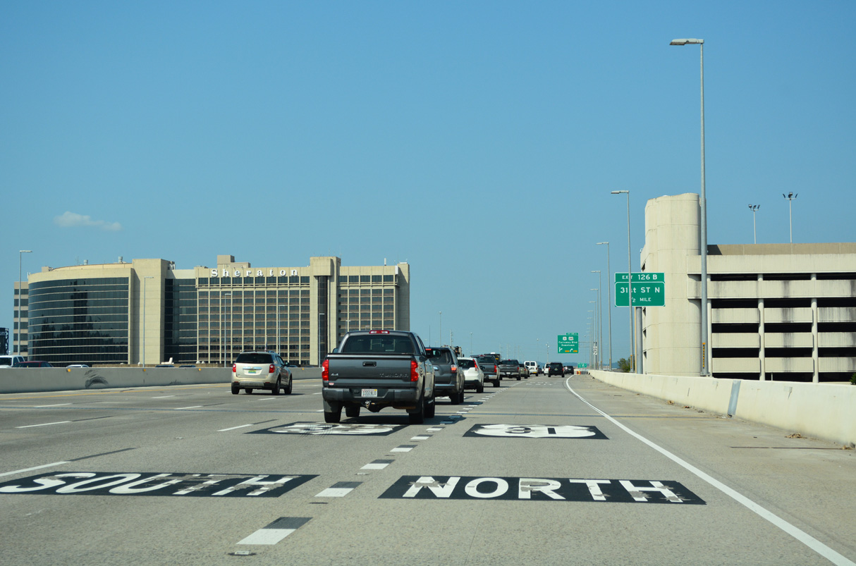
I-20/59 between Interstate 459 and Exit 118 is designated the Alabama Adventure Freeway.
06/09/17

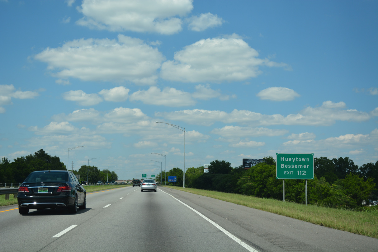
The split diamond interchange at Exit 112 connects I-20/59 with the couplet of 18th and 19th Streets northwest of Downtown Bessemer.
06/09/17

The naming convention for the Bessemer street grid assigns the Street suffix for northwest to southeast orientated roads and Avenue for southwest to northeast roads.
06/09/17
The couplet of 18th/19th Streets combines along a four-lane boulevard (19th Street N) northwest from I-20/59 to the city of Hueytown.
06/09/17

I-20/59 though Bessemer was constructed in the 1970s. Displaying several blocks of the city street grid, the exchange at 18th/19th Streets was completed in 1977.
06/09/17

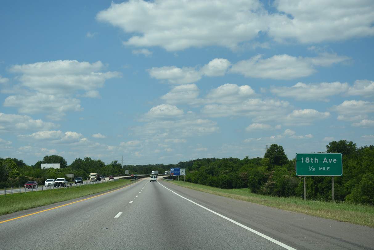
The diamond interchange at Exit 113 connects I-20/59 with 18th Avenue adjacent to Jaybird Road and the Brighton city line. The city of Lipscomb is east of parallel U.S. 11/SR 5.
06/09/17

I-20/59 span 24th Street N north beyond this shield assembly.
06/09/17
I-20/59 cross Valley Creek and a Birmingham Southern Railroad line north ahead of Exit 113.
06/09/17

18th Avenue leads west to 24th Street N and east to adjacent Jaybird Road, south of Main Street in Brighton.
06/09/17

These reassurance markers for I-20/59 preceding the Woodward Road underpass in north Bessemer were gone by 2022.
06/09/17

Parallel Jaybird Road meets I-20/59 directly at a half diamond interchange (Exit 115) in the city of Midfield. The advance sign for Exit 115 was knocked over in 2022 and subsequently removed.
06/09/17
Jaybird Road ties into Allison-Bonnett Memorial Drive just north of Exit 115 and east of Hueytown. A guide sign for Exit 115 was installed here in 2022.
06/09/17
A wye interchange connects parallel Allison-Bonnett Memorial Drive with I-20/59 ahead of Fairfield Boulevard and these confirming markers. The ensuing 2.5 miles run along or adjacent to the west Fairfield city line.
06/09/17

Continuing northeast, I-20/59 meet Valley Road and E.J. Oliver Boulevard at a split diamond interchange (Exit 118) in Fairfield.
06/09/17
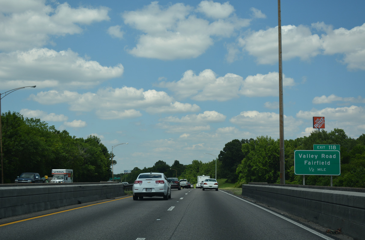
Exit 118 departs in a half mile for to E.J. Oliver Boulevard and the Miles College Historic District. E.J. Oliver Road leads south from Valley Road to the Fairfield Civic Center.
06/09/17

Donald Parkway extends northeast from Valley Road and I-20/59 through Fairfield to a half diamond interchange (Exit 119 B) with the freeway in Birmingham.
06/09/17

I-20/59 expands from four to six overall travel lanes north from the ramps with Valley Road at Exit 118.
11/04/09

Lloyd Noland Parkway angles northeast from 45th Street in Fairfield to become Avenue E at 36th Street and the Birmingham city line. This urban parkway was named for Lloyd Noland Hospital. That facility was purchased by HealthSouth in the 1990s, which led to the parkway being renamed after then-CEO Richard M. Scrushy. Lloyd Noland's name was restored by Fairfield city council on September 13, 2007 after Scrushy's involvement in a multi-billion dollar accounting fraud.
06/09/17

I-59/20 enter the city of Birmingham by 36th Street. The freeway proceeds one mile north from the bridge spanning Avenue I and 34th Street at Exit 119 B to the split diamond interchange (Exit 120) with Ensley 5 Points W Avenue and SR 269 (20th Street Ensley).
06/09/17
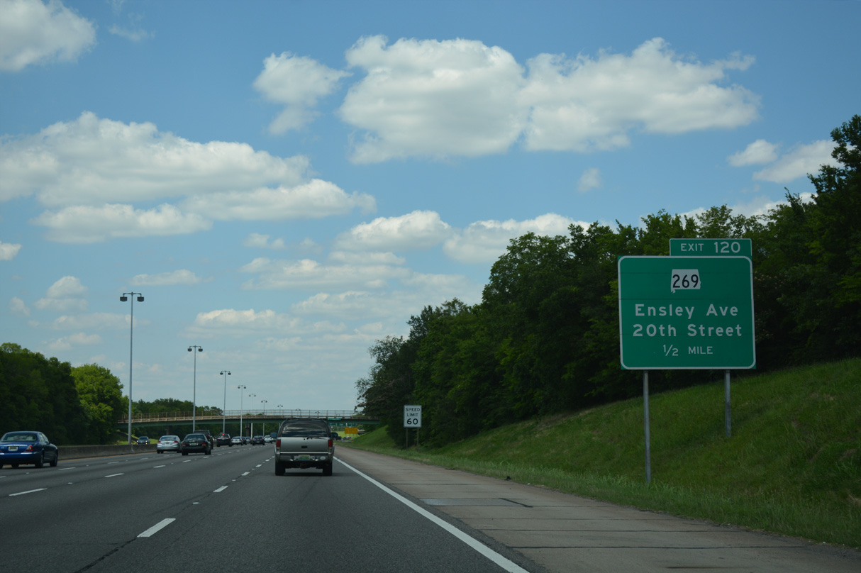
Ensley 5 Points W Avenue leads south from SR 269 (20th Street) and the Ensley neighborhood to Ensley Highlands and U.S. 11/SR 5 (Bessemer Road)at Five Points West Shopping Center.
06/09/17

SR 269 commences west along 21st Street Ensley from the intersection with Avenue V and Pike Road, 0.19 miles east of I-20/59 at Exit 120.
06/09/17

Ensley 5 Points W Avenue north connects Exit 120 with SR 269 along 20th Street Ensley. 41.52 miles in length, SR 269 travels northwest to Maytown, Sylvan Springs and Jasper.
06/09/17
A half diamond interchange (Exit 121) adds traffic to I-20 east / I-59 north from Bush Boulevard ahead of these reassurance markers.
09/11/20

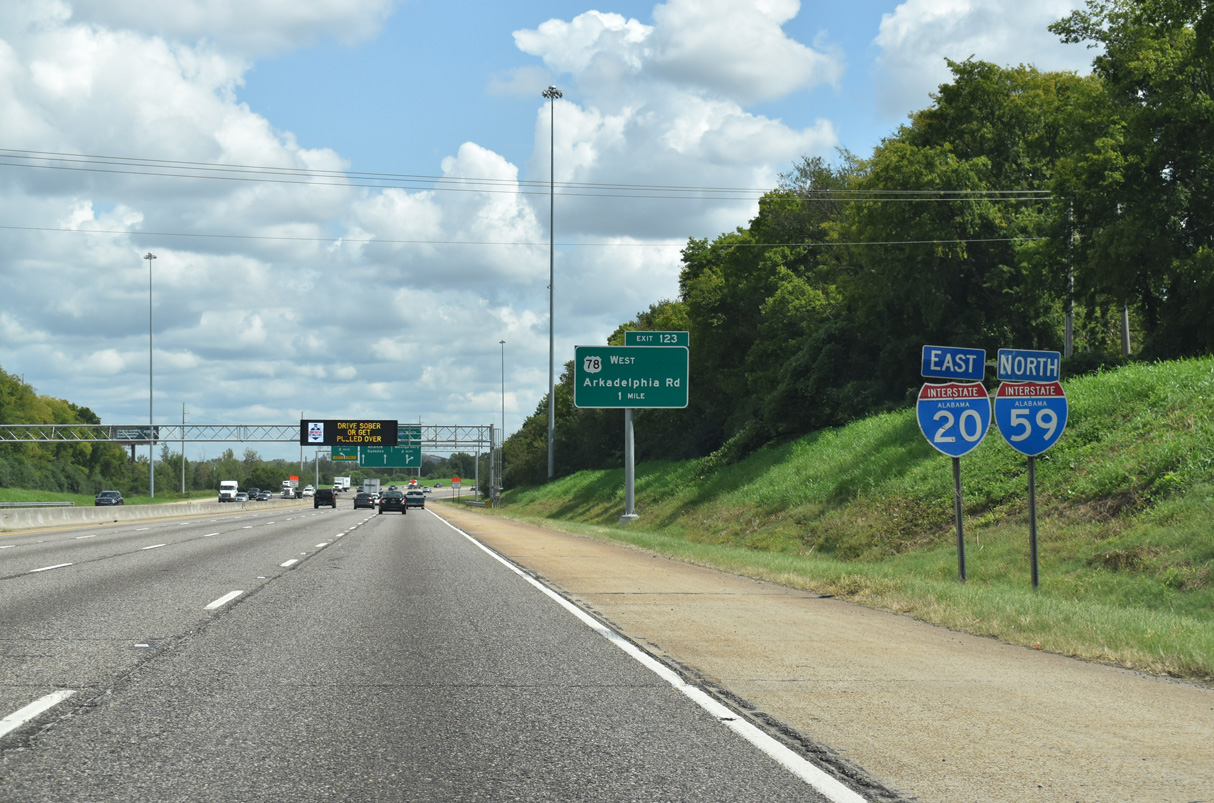
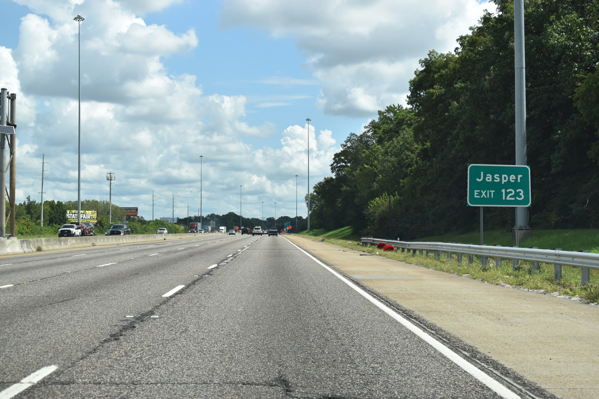
Turning eastward, I-20/59 next meet U.S. 78 (Arkadelphia Road) at a parclo interchange (Exit 123). Arkadelphia Road is a five lane boulevard serving the Owenton and East Thomas neighborhoods of the city, Birmingham Southern College and Legion Field.
09/11/20
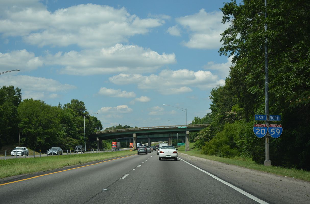
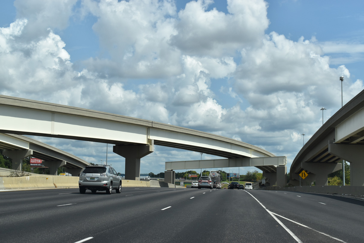
The first in a series of overheads for the systems interchange (Exit 124) joining I-59/20 north with Interstate 65.
09/11/20
U.S. 78 turns west onto the Bankhead Highway where Arkadelphia Road intersects SR 378 (Finley Boulevard) at Thomas. SR 5, not shown on Exit 123 guide signs, combines with U.S. 78 west from U.S. 11 north. SR 5 follows Old U.S. 78 north from I-22 to the Walker County seat of Jasper.
09/11/20

Despite signage at Exit 123, U.S. 78 continues south along Arkadelphia Road 1.05 miles to U.S. 11 (3rd Avenue W). U.S. 11/78 overlap east to the Birmingham central business district.
A sign replacement made here added Road to Arkadelphia.
09/11/20

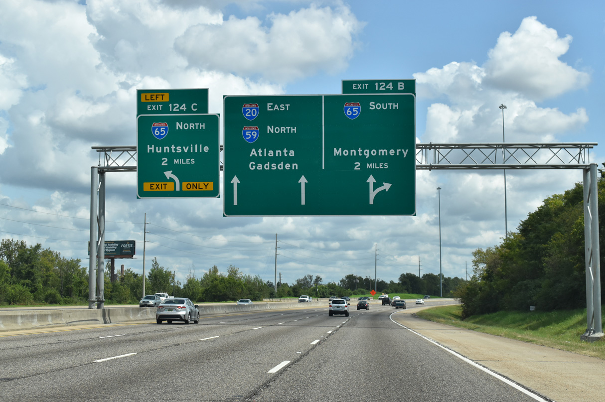
Continuing east by the East Thomas neighborhood, I-20/59 converge with Interstate 65 at an interchange where the roadways for both freeways switch sides to accommodate left exit ramps.
09/11/20

Construction between 2016 and 2020 rebuilt I-59/20 from I-65 to U.S. 31/280 (Elton B. Stephens Expressway). Part of that work included building a new ramp (Exit 124 D) to Downtown Birmingham.
09/11/20

Exit 124 A was previously assigned for I-65 south. 2016-20 road work also added a new ramp connecting I-20/59 north with Exit 261 D from I-65 south to 6th Avenue N.
09/11/20

The two-lane ramp at Exit 124 B joins Interstate 65 south to Homewood, Hoover and Montgomery.
09/11/20
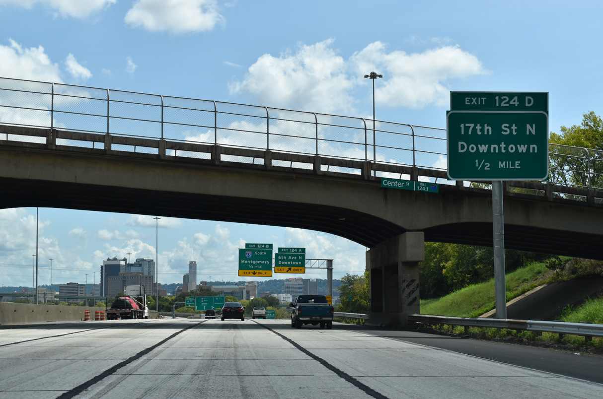
The flyover from Exit 124 D ties into 17th Street N south at Rev. Abraham Woods, Jr. Boulevard (6th Avenue N) two blocks north of Kelly Ingram Park and the Birmingham Civil Rights Institute.
09/11/20

6th Avenue N (Rev. Abraham Woods, Jr. Boulevard) leads west from I-65 to the Graymont neighborhood and east to Downtown.
09/11/20
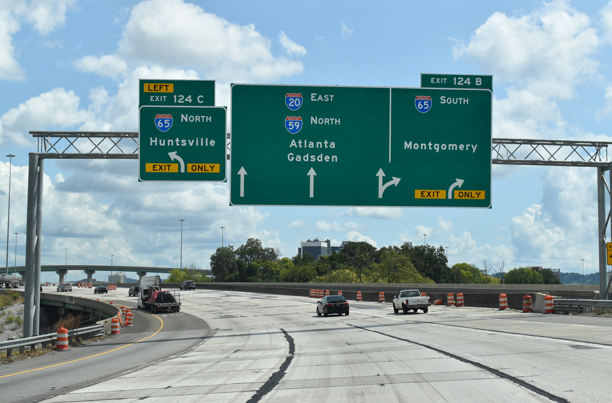
I-65 heads 3.2 miles north from Left Exit 124 B to Exit 265 A for Interstate 22 west. I-22 joins Birmingham with Jasper, Tupelo, Mississippi and Memphis, Tennessee.
09/11/20

Left Exit 124C departs for I-65 north to Fultondale, Cullman and Huntsville. Prior to the 1980s, guide signs for I-65 north referenced Nashville instead of Huntsville.
09/11/20

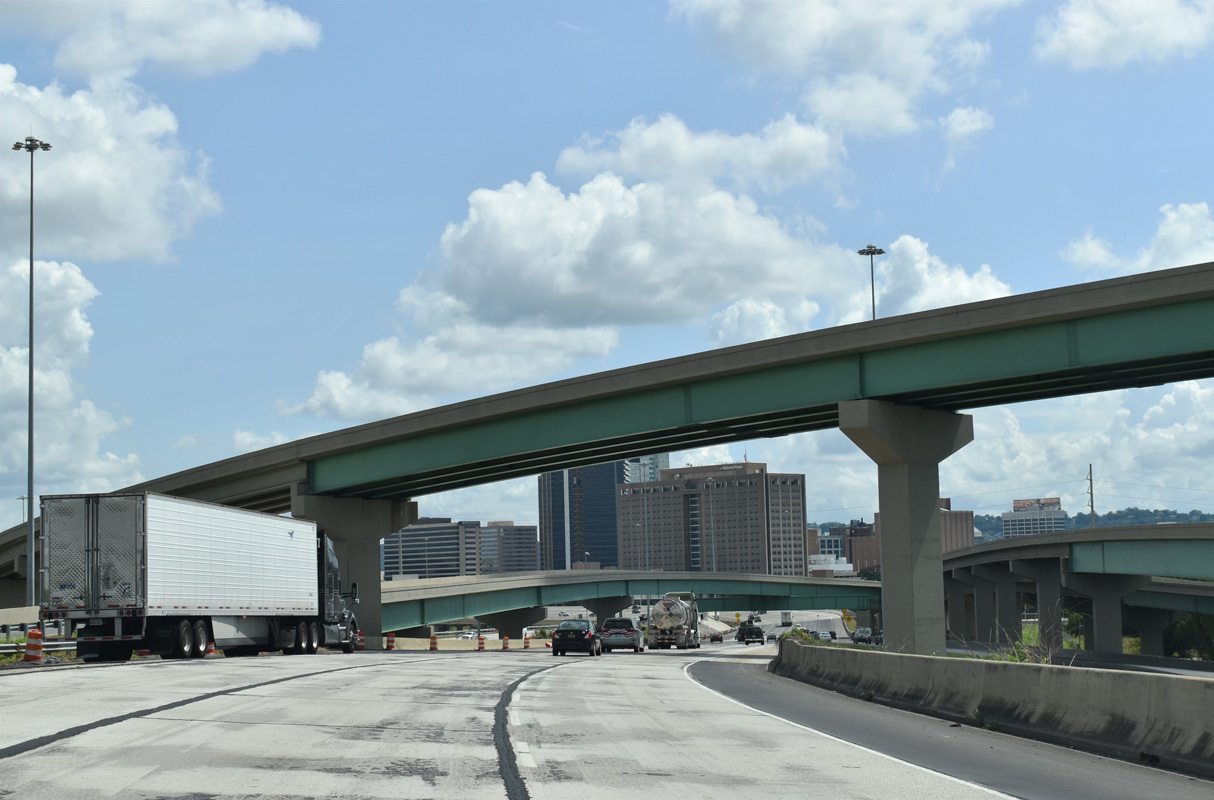
High flyovers constructed at the interchange locally known as Malfunction Junction serve local exits and entrance ramps from the Birmingham street grid.
09/11/20
Prior to the addition of the flyover ramps to 17th Street N, a weaving traffic pattern was in place along I-20/59 north from I-65 to the previous ramp for what was Exit 125 A. Exit 125 B to 22nd Street was also eliminated during 2016-20 construction.
09/11/20

2016-20 construction demolished the previous elevated roadway dating from 1971 and replaced it with a new ten lane viaduct system.
09/11/20
High-rises in Downtown Birmingham can be no higher than 454 feet. This restriction is mandated by the FAA (Federal Aviation Administration) due to the proximity of the central business district to the Birmingham International Airport (BHM) flight path (J. Cozart, personal communication, October 15, 2003).
06/16/22

A lane drop occurs along I-20/59 northbound for Exit 126 A to U.S. 31 south / U.S. 280 east and 26th Street N at 6th Avenue N.
09/11/20
U.S. 31/280 overlap south along a limited access highway officially designated the Elton B. Stephens Expressway. The freeway is also shown on maps and referred to on area traffic reports as the Red Mountain Expressway.
06/16/22

Eliminating a weaving traffic pattern, 2016-20 road work also extended the ramp for Exit 126 B onto a flyover. 31st Street N leads to the Sloss Furnaces, a local historical attraction.
09/11/20

The multi-level interchange at Exit 126 A represents the west end of U.S. 280. 392 miles in length, U.S. 280 travels southeast from Birmingham to Columbus, Georgia, and east across the Peach State to U.S. 80 at Blichton.
06/16/22

U.S. 31/280 overlap south across Red Mountain near Vulcan Park to the city of Homewood. U.S. 31 extends north from the end of the Red Mountain Expressway along Carraway Boulevard to North Birmingham.
06/16/22

The original alignment of U.S. 31 through the Downtown area was along 26th Street south to 8th Avenue and an overlap with U.S. 78 along 24th Street. U.S. 280 tied into U.S. 31 along 20th Street via Highland Avenue.
06/16/22

Historically U.S. 280 ended at the intersection of 24th Street and 1st Avenue N, where U.S. 31/78 met U.S. 11.
09/11/20

The flyover to U.S. 31 north ties into 26th Street N, three blocks south of where U.S. 31 lowers from the Red Mountain Expressway onto Carraway Boulevard.
06/16/22
31st Street run through older industrial areas of the city, which include the Sloss Furnaces, and the Norwood neighborhood to the north. The Sloss Furnaces were used for iron ore smelting between 1882 and 1972. Following their closure, they were transitioned into a tourist attraction that shows how iron was smelted at the turn of the century.
09/11/20
I-20/59 lower from the viaduct passing north of Downtown Birmingham to grade level beyond the 28th Street N underpass.
09/11/20

SR 79 begins along Tallapoosa Street north from Exit 128. Tallapoosa Street becomes Vanderbilt Road north from nearby Lake Boulevard to the Inglebrook neighborhood.
09/11/20
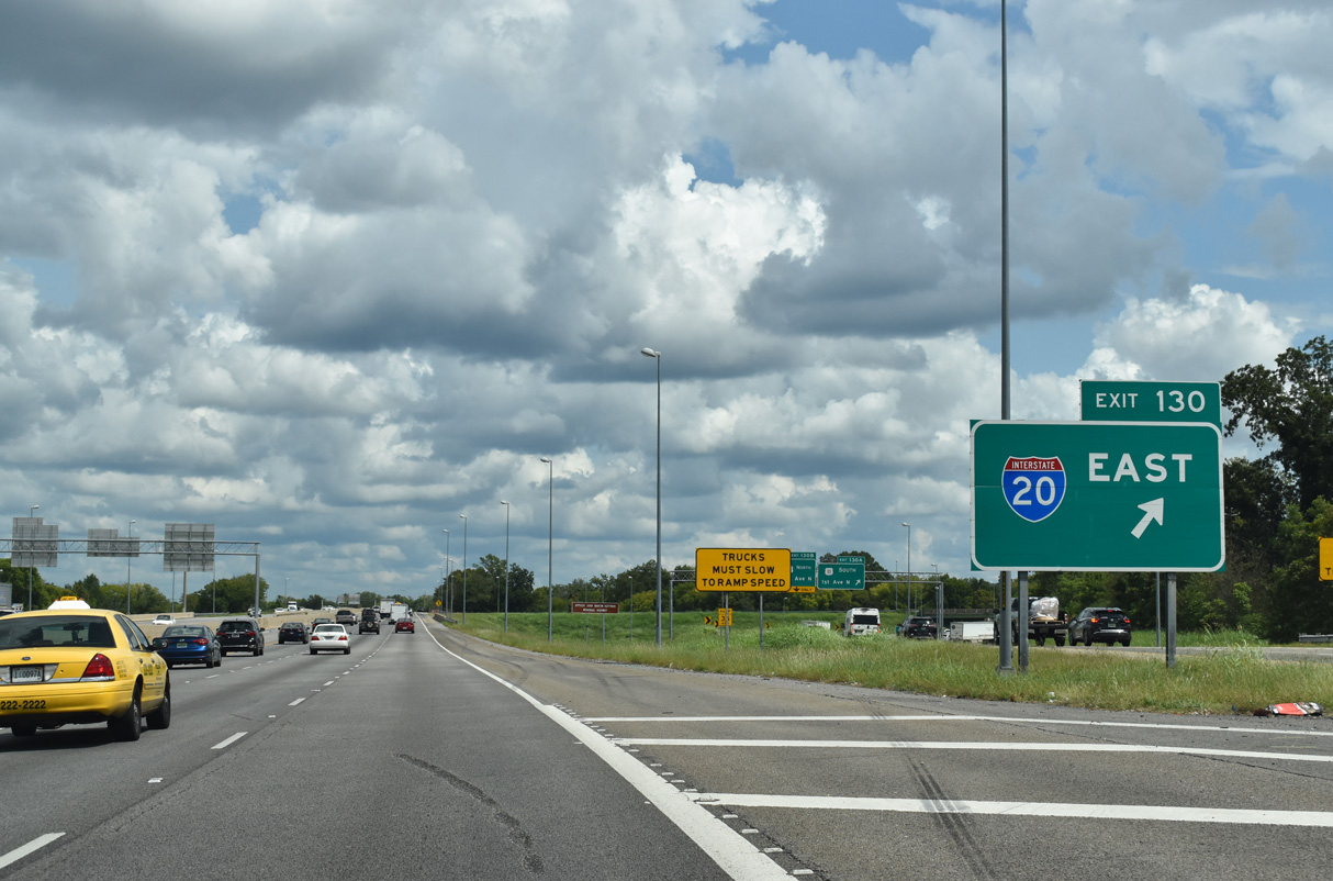
A lane drop occurs at Exit 128. I-59/20 continues east from SR 79 (Tallapoosa Street) with six overall lanes to their separation at Exit 130.
09/11/20

The directional ramp at Exit 128 links I-59/20 north with SR 79 north to Tarrant City, Robinwood and Pinson.
09/11/20

SR 79 travels 117 miles northward from Birmingham to Tarrant City, Guntersville and the Tennessee state line beyond Hytop.
09/11/20

SR 79 originally followed Vanderbilt Road southwest from Tallapoosa Street to 12th Avenue N and at U.S. 31 (26th Street N).
09/11/20
09/11/20

Referenced as Airport Boulevard on Exit 129 guide signs, Messer Airport Highway joins I-20/59 with Birmingham-Shuttlesworth International Airport (BHM). The Southern Museum of Flight is located east of the airport at 73th Street N and 43th Avenue N.
09/11/20

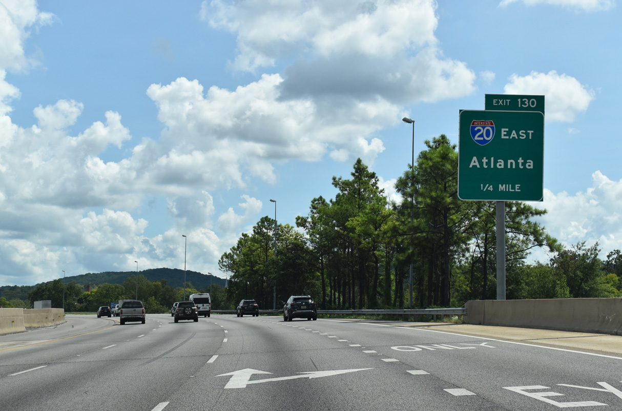
I-20 branches east from I-59 north at a trumpet interchange (Exit 130) in one mile. The succeeding exit serves the Eastwood, Avon Park, Kingston and Woodlawn neighborhoods via Messer Airport Highway.
09/11/20

Messer Airport Highway spurs north to the passenger terminal at BHM Airport. South of Exit 129, Messer Airport Highway continues onto 5th Avenue N at the Central City area of Birmingham.
09/11/20
I-20/59 overlap 153 miles north from west of Meridian, Mississippi to Exit 130 by the Wahouma neighborhood of Birmingham.
09/11/20
The last reassurance markers for the I-20/59 overlap stand along the entrance ramp from Messer Airport Highway.
09/11/20

Interstate 59 continues 52 miles northeast to Gadsden and 131 miles to I-24 near Chattanooga, Tennessee.
09/11/20
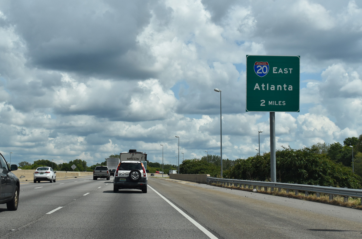
Interstate 20 heads 55 miles east to Anniston and reaches Atlanta in 135 miles. The route concludes to the east at I-95 in Florence, South Carolina.
09/11/20
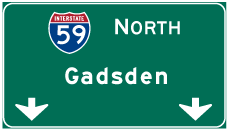
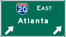
Photo Credits:
- Alex Nitzman: 06/06/17, 06/07/17, 06/09/17, 06/16/22
- ABRoads: 11/04/09, 06/09/17, 09/11/20
- AARoads: 09/11/20
Connect with:
Page Updated Friday February 27, 2026.