
U.S. Highway 50

Looking north from the Heavenly resort toward South Lake Tahoe, Stateline, and the mountains surrounding lake's north shore. U.S. 50 encircles the southern shore. - 07/22/2009
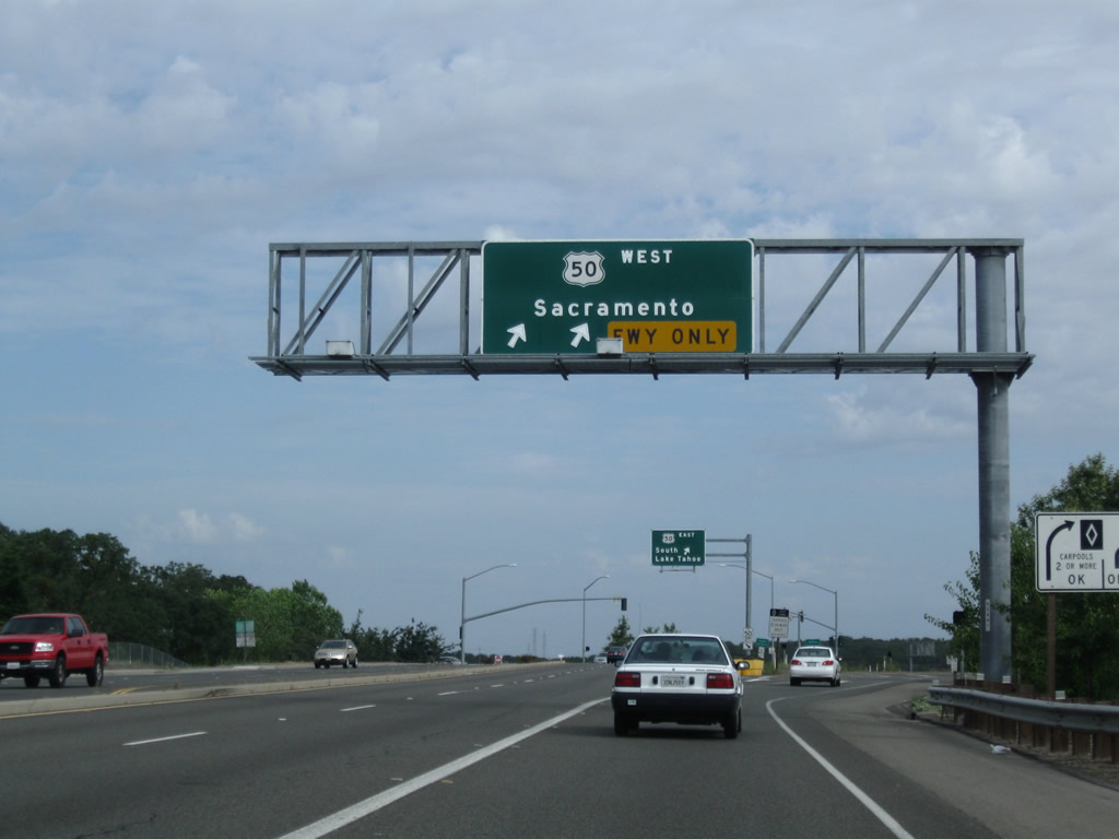
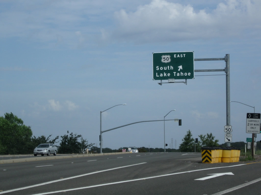
U.S. 50 begins in West Sacramento, starting together with Business Loop I-80 and unsigned Interstate 305 into the capital city of Sacramento. U.S. 50 splits away from the business loop freeway near Downtown, and it continues as its own freeway from that point east to Placerville, serving several eastern suburbs of Sacramento including Rancho Cordova and Folsom. Through Placerville, U.S. 50 loses its freeway status and regains it briefly east of town. Eventually, U.S. 50 becomes a two-lane mountain highway, passing through the American River Canyon and passing over Echo Summit before entering Tahoe Valley. The South Shore of Lake Tahoe is served by U.S. 50, and the highway enters Nevada in the shadow of several casinos at the state line.
U.S. 50 California Guides
- East:
- Capital City Freeway - Yolo County and city of Sacramento
- Sacramento County
- El Dorado County - El Dorado Hills to Pollock Pines
- El Dorado County - Pollock Pines to Meyers
- El Dorado County - Echo Pass to South Lake Tahoe
- West:
- El Dorado County - South Lake Tahoe to Echo Pass
- El Dorado County - Meyers to Pollock Pines
- El Dorado County - Pollock Pines to El Dorado Hills
- Sacramento County
- Capital City Freeway - city of Sacramento and Yolo County
U.S. 50 no longer exists west of Sacramento; it used to extend all the way to San Francisco. From Sacramento, U.S. 50 used to travel south along a shared alignment with California 99 (then U.S. 99) to Stockton, then turned southwest to Tracy (roughly along the Interstate 205 corridor), then west and northwest via Interstate 580 to Oakland. The final distance into San Francisco via the San Francisco-Oakland Bay Bridge was designated as both U.S. 40 and U.S. 50 until the bridge was renumbered as part of Interstate 80.
In addition to local street names, portions of U.S. 50 follow the Lincoln Highway through California. The remainder of the Lincoln Highway accompanied U.S. 40 across the state.
U.S. 50 Alternate
U.S. 50 has one bannered auxiliary route: U.S. 50 Alternate. This highway is only signposted during events that close the mainline route through the American River Canyon or Echo Pass (between Pollock Pines and South Lake Tahoe). From Pollock Pines, U.S. 50 Alternate follows El Dorado County E-16 (Sly Park Road) south, Mormon Emigrant Trail east, California 88 (Carson Pass Highway) east, and California 89 north to rejoin U.S. 50 at South Lake Tahoe. U.S. 50 Alternate is not a permanent alternate route as typically seen elsewhere in the country. Instead, U.S. 50 Alternate in California is only signed when conditions warrant as a 66-mile Detour U.S. 50 route. It may be signed for traffic control purposes or during conditions that warrant road closure, including fires, floods, landslides, road construction, and accidents. Most of the signs for U.S. 50 Alternate appear to have been installed around 1997 in conjunction with a project to repair several landslide issues in the American River Canyon. Few if any of the signs placed then have been replaced or added since that time.

Old U.S. 50 (Lincoln Highway) follows the shadow of massive Interstate 580 closely in some areas and far away from its replacement in other areas. For the most part, U.S. 50 retains the charm of a country road, with ranch access and connections to the wind farms and power plants common on Altamont Pass.
08/21/03

Several older railroad bridges cross over Altamont Pass, including these bridges on old U.S. 50 (Lincoln Highway).
08/21/03

Between the Interstate 5-Interstate 205 split and California 120, Manthey Road (which runs parallel to Interstate 5 through Lathrop) is the old alignment of U.S. 50 (Lincoln Highway). This series of pictures follows Manthey Road as it crosses two sets of bridges. The first is a 1932 bridge (note date stamp) that crosses the Paradise Cut. The second, much more substantial bridge, carries Manthey Road over the San Joaquin River.
09/05/10

Northbound Manthey Road (Old U.S. 50 / Lincoln Highway) crosses a Pratt through truss bridge to pass over the San Joaquin River. Built in 1926, the bridge has a newer, parallel pedestrian/bicycle bridge alongside it and extends for about 539 feet in length with a 15'3" vertical clearance from the bridge deck. This area is not far from Mossdale Crossing. A parallel span to allow for a four-lane U.S. 50 through here was built in 1949; today, this second span is still in use as part of the transition ramp from California 120 west to Interstate 5 south and Interstate 205 west.
09/05/10

Business Loop I-80, California 99, and U.S. 50 shields on northbound Stockton Boulevard at the U.S. 50 interchange in Sacramento.
March 2000

This U.S. 50 trailblazer is posted on southbound 57th Street at Elvas Avenue in Sacramento. Elvas Avenue travels south to 65th Street en route to U.S. 50.
12/29/04

Westbound J Street approaches northbound 57th Street and southbound Elvas Avenue in Sacramento. This is a trumpet interchange between J Street and Elvas Avenue, which travels south to 65th Street en route to U.S. 50.
12/29/04

Southbound 65th Street approaches S Street and U.S. 50 in Sacramento. Note that the overhead sign for U.S. 50 west is for Business 80 and California 99 but does not list U.S. 50 (except on the freeway entrance signs).
12/29/04

This U.S. 50 trailblazer is found on 59th Street in Sacramento.
04/01/00

Northbound Zinfandel Drive approaches the on-ramp to the westbound U.S. 50 freeway.
08/22/03

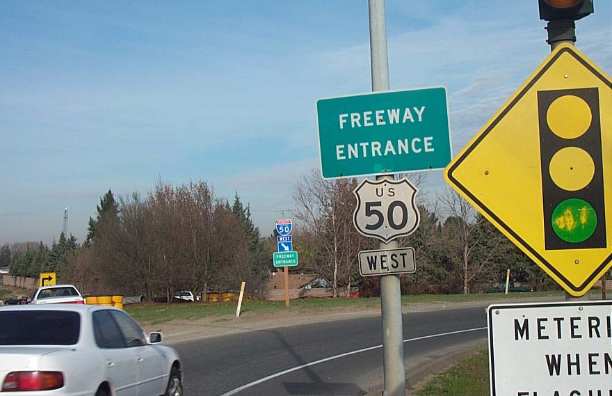
This is a typical U.S. 50 freeway entrance shield assembly found in the greater Sacramento area. All of U.S. 50 is a freeway between West Sacramento and the outskirts of Placerville.
March 2001

This U.S. 50 shield is found as a reassurance marker along the mainline freeway.
March 2001
Southbound Prairie City approaches U.S. 50 (El Dorado Freeway) in Folsom. The first right connects to U.S. 50 west to Sacramento, and the second right flies over U.S. 50 to merge onto eastbound U.S. 50 en route to Placerville.
06/20/09

This overhead sign and freeway entrance shield assembly are posted along northbound East Bidwell Street in Folsom at the U.S. 50 interchange.
01/15/06
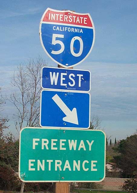
Long since corrected, this shield assembly erroneously showed an Interstate 50 shield in lieu of a U.S. 50 shield.
March 2001

Nearing the California-Nevada state line, U.S. 50 (Lake Tahoe Boulevard) approaches the "downtown" area of the city of South Lake Tahoe, which features Heavenly Village and a variety of shops, restaurants, and hotels located near the Stateline casinos. Access to the lakeshore is available via several local roads leading north from U.S. 50. A plaza on the south side of U.S. 50 makes for pedestrian access and a venue for events such as Hot August Nights and concerts.
07/28/12
07/29/12
07/30/12

Explore Tahoe: An Urban Trailhead is located on the south side of U.S. 50 (Lake Tahoe Boulevard) just a few blocks west of the California-Nevada state line. Inside are exhibits that showcase the natural wonder that is Lake Tahoe, including fascinating imagery that showcases the lake's depth and unusually clear waters.
07/30/12

The platform on the gondola ride to the top of Heavenly provides incredible views. Visible below are the mountains ringing the alpine lake, the Heavenly Village/Stateline area, and the south shore of Lake Tahoe.
07/30/12

Looking north past U.S. 50 (Lake Tahoe Boulevard), high clouds brought on a gorgeous sunset at Heavenly Village in downtown South Lake Tahoe.
08/03/12

U.S. 50 Alternate, which was signed in 1997-1998, began at the Sly Park Road interchange in Pollock Pines. El Dorado County E-16 follows the former route south along Sly Park Road through to the intersection with Mormon Emigrant Trail.
07/28/12

El Dorado County E-16 (Sly Park Road) south curves southeast through forestland. Most of the U.S. 50 Alternate signs formerly posted along this road were removed by 2012.
07/28/12

Skipping ahead, this view of former U.S. 50 Alternate (Mormon Emigrant Trail) east is taken a couple miles before the junction with California 88 near a westbound mileage sign.
09/05/10

Mormon Emigrant Trail is a two-lane highway for its entire length between Sly Park Road and California 88, including the narrow segment near Jenkinson Lake.
09/05/10

Mormon Emigrant Trail east approaches California 88 (Carson Pass Highway). U.S. 50 Alternate combined with California 88 east from this point.
09/05/10

U.S. 50 Alternate, which was best described as a detour route for U.S. 50 in the event of weather or traffic problems through the American River Canyon, followed Mormon Emigrant Trail between Jenkinson Lake and the Iron Mountain Sno-Park. While most signs for U.S. 50 Alternate were removed by 2012, this mileage sign along westbound Mormon Emigrant Trail after SR 88 alludes to its role as a former US highway.
09/05/10

Neither the elements nor bullets were kind to this U.S. 50 Alternate sign, which was the last uncovered sign for the route in 2010. This is a summer-only detour route; it is closed during winter.
09/05/10

Beyond the mileage sign, a second sign advises motorists that off-roading is restricted from Mormon Emigrant Trail.
09/05/10

Nearing U.S. 50 along El Dorado County E-16 (Sly Park Road) north in Pollock Pines. U.S. 50 Alternate ended here.
07/28/12

U.S. 50 leads east back to South Lake Tahoe. The US highway ventures west to Placerville and Sacramento. Sly Park Road concludes just south of the interchange at Pony Express Trail (Old U.S. 50).
07/28/12
Photo Credits:
- Andy Field: 08/21/03, 08/22/03, 12/29/04, 01/15/06, 06/20/09, 09/05/10, 07/28/12, 07/29/12, 07/30/12, 08/03/12
- Dominic Ielati: March 2000, 04/01/00
- Joe Rouse,: March 2001
- Joe Rouse: March 2001
Connect with:
Page Updated Tuesday September 04, 2012.