This past weekend’s roadtrip took us to Jacksonville, Florida, Savannah, Georgia, Charleston and Myrtle Beach, South Carolina, and Wilmington, North Carolina. But before I get into the details of those travels, it is time to take care of unfinished business…
Now two and half months removed from the trip, here’s a summary of Day 6 of our Northwest U.S. roadtrip.
Chris Kalina joined Andy and I for the two-day marathon drive from Seattle east to Montana and back. To get as far east during daylight hours, the day began before sunrise in Burien, Washington with myself loading up on coffee at 5:45 am (!). We arranged to meet Chris at a park and ride lot next to Interstate 405 at Bellevue by 6:30, but a gnarly traffic accident clogged the northbound lanes of I-405 at 6:15, causing us to get there 15 minutes late. Chris also showed up late, so all was ok, and we piled into our rental car and ventured east toward Snoqualmie Pass by 7 am.
The climb eastward into the Cascade Mountains was magnificent with layers of low clouds and fog shrouding the valleys and passes of Interstate 90.
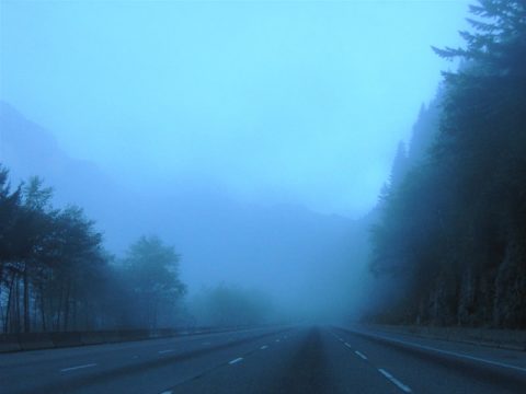
Climbing toward the West Summit interchange (Exit 52) on Interstate 90 east. Snoqualmie Pass rises to 3,022 feet and is snow covered for most of the year. During this last day of August, the temperature was already down to 37 degrees!
One brief stop just west of the Pass revealed a small section of two-lane concrete original U.S. 10. Old U.S. 10 is partially signed as Washington 905, and a stretch of the original roadway passes under I-90 next to a babbling brook. Also of note at the Pass are Interstate 90 Washington shields on overhead signs at Exit 64.
As we lowered into the rainshadow of the Cascades, tall trees gave way to low scrub brush and vast farmland. Just east of Cle Elum at the town of Ellensburg is the Interstate 90 junction with Interstate 82 & U.S. 97. Interstate 90 continues east to the Columbia River Valley, but Interstate 82 & U.S. 97 immediately ascend dramatically to Vanderbilt Gap.
Interstate 82 would lead us southeast to rejoin Interstate 84 near Hermiston, Oregon, rejoining that freeway en route to Boise, Idaho. Along the southward drive to the Columbia River are the longest concrete arch bridges in the United States. Named the Fred G. Redmon Memorial Bridge, the 1971-completed spans travel 1,336 feet over the Selah Creek Canyon.
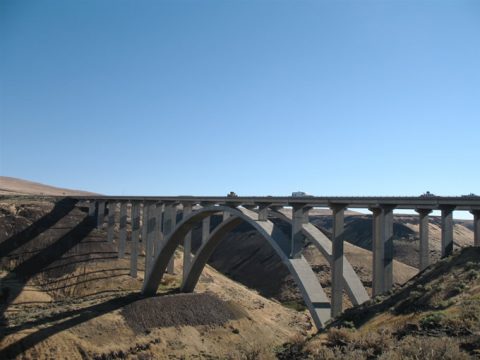
Peering east at the bridge from the adjacent westbound side rest area. An eastbound area lies north of the bridge.
Further south Interstate 82 & U.S. 97 join U.S. 12 through the Yakima area. U.S. 97 veers southwest from south Yakima, but U.S. 12 remains overlapped east to Interstate 182. U.S. 395 later joins Interstate 82 south from the Tri-Cities to Umatilla, Oregon.
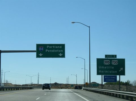
What is wrong with this picture? Upon entering the state of Oregon, Interstate 82 splits with U.S. 395 at Exit 1 for U.S. 730. The pull-through overhead refers to Interstate 84, even though Interstate 82 does not reach that freeway for another 10 miles! Bad ODOT!
U.S. 730 is the highest numbered U.S. highway in existence. It was number two originally as the decommissioned U.S. 830 once held the crown. That route is now Washington 14, and it meets Interstate 82 at its final Washington interchange.
Back on Interstate 84, we continued east on the freeway all the way to Boise, Idaho. Along the way are the small cities of Pendleton, La Grande, Baker City, and Ontario, all of which appear to be original railroad towns in the desert or high country of eastern Oregon. Also noteworthy along the way is the freeway rise to Deadman Pass at Umatilla Indian Reservation. Carriageways of Interstate 84 partition there to make the climb/descent between the low desert and mountains. Near the pass itself is a vista point giving drivers a vast view of the western desert.
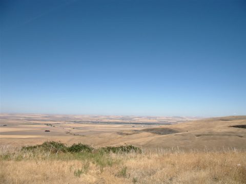
A phenominal view of the Oregonian desert is found at the view point pull-off of Interstate 84 eastbound on the rise to Deadmans Pass. Looking west here, Interstate 84 climbs upward to the right and vast fields of farmland spread south from Pendleton to the left.
Tree lined hills overtake the landscape from Emigrant Springs State Park eastward. The landscape remains similar through to La Grande, when Interstate 84 enters a wide plateau. Beyond there the mountains are devoid of trees for the most part as another rain shadow sets in place. By Ontario Interstate 84 lowers again and travels through farmland to the Snake River, the Idaho State line.
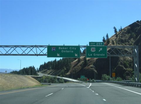
U.S. 30 is relegated to act as a business loop to the Interstate 84 mainline through the cities of eastern Oregon. Here U.S. 30 departs the freeway for a short stretch of independent routing through La Grande. Farmfields and dry hillsides encompass the landscape from La Grande southward along Interstate 84.
Speed limits increase from 65 to 75 mph once Interstate 84 enters the Gem State. The 75 mph speed limit provides for a fast drive to the sprawling metropolitan area of Boise. The capital city lies within an area known as the Treasure Valley. It is one of the fastest growing cities in the Rocky Mountain states.
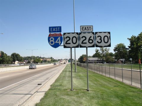
A bank of shields display Interstate 84 and U.S. 20-26-30 along their brief overlap through Caldwell. Welcome to the capital city metro area!
The metro area extends west to include Caldwell, Nampa, and Meridian, and traffic congestion reflects that outward expansion. A business loop for Interstate 84 serves Caldwell and Nampa, and at Caldwell (Exit 26) U.S. 20 and 26 join Interstate 84 and its companion U.S. 30 for a four-way overlap through town. A new interchange was under construction to join Interstate 84 and U.S. 30 with relocated Idaho 55 at Exit 33. The old Idaho 55 follows Nampa Boulevard north from Business Loop I-84 to Exit 35. Upon completion, the new interchange will allow for Idaho 55 through traffic to bypass Nampa by joining the freeway more directly from the west.
Idaho 55 joins 30 on Interstate 84 east from Nampa all the way to Exit 46 at Meridian. The state highway departs via a wide and congested arterial north to Idaho 44 at Eagle (we’ll visit that in a bit). Interstate 84 meanwhile abruptly widens from four to eight lanes at Exit 44 (Idaho 64). When we say abrupt, we mean it as westbound traffic was solid for two miles between Exits 46 and 45 reflecting the quick lane reduction at Idaho 69.
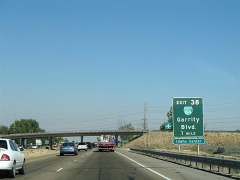
Approaching the Exit 38 interchange with Business Loop Interstate 84 (Garrity Boulevard) east of Caldwell. Much to our surprise, a good deal of button copy remained in use along Interstate 84 throughout the Boise metropolitan area.
The traffic crazyness continues as Interstate 84 splits with Interstate 184 at Exit 49, the so-called “Flying Y” interchange. Interstate 184 constitutes a freeway spur into downtown Boise from the west, ending a short distance from the state capital complex. The freeway carries six lanes and was busy in both the inbound and outbound directions between 4-5 pm. Recent reconstruction of the western terminus entailed building wider high speed ramps between the only two Boise area freeways. It seems to have worked for now…
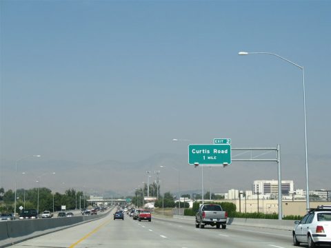
Traveling east toward downtown Boise along the busy Interstate 184. The Sawtooth Range makes up the eastern horizon for the metropolitan area.
This reminded me a lot of Tortugas Mountain east of Las Cruces, New Mexico, which makes up the eastern horizon for that city.
In downtown, Interstate 184 merges with U.S. 20 & 26 at the Boise before ending in the central business district. U.S. 20 & 26 follow the busy one-way street couplets of Myrtle and Front Streets from the freeway east to Broadway Avenue. Broadway Avenue provides the main route to Boise’s Airport and points southeast.
A brief drive through downtown later, we head back west on Interstate 184 to Interstate 84 and all of its traffic congestion. For the orientation of the Treasure Valley, Interstate 84 provides the only freeway between the growing suburbs and city core. Other area roads seemed to fare worse, as many of the interchanges suggested. One such road to suffer from amazing amounts of traffic was Idaho 55. We traveled that north to reach Hells Canyon and did not expect its routing along Eagle Road to be so busy and overwhelmed with motorists.
Traffic trudged from Interstate 84 northward between traffic light cycles along Idaho 55. A “Game crossing” sign posted near the north end elludes to a likely different landscape at the time it was posted compared to the sprawly landscape today.
Turning onto the Idaho 44/55 overlap did not seem to help matters much either, as the sprawl continued to their split east of the Eagle business district. Idaho 55 continues north from there with five overall lanes to the Payette River Scenic Byway north of Beacon Light Road. A lengthy descent carries the state highway over the 4,242 foot Horseshoe Bend Hill north of the Boise County line. A 7% grade awaits northbound travelers over the course of five miles from the hill’s crest to into the village of Horseshoe Bend itself.
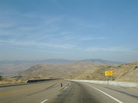
Beginning the descent from the top of Horseshoe Bend Hill along Idaho 55 northbound. Four runaway truck ramps lie along the five-mile descent to Horsehoe Bend.
A brief jaunt west took us to Gem County along Idaho 52. From there we continued north along Idaho 55 through the scenic Payette River Valley. Construction along the narrow roadway involved repairing a concrete arch bridge over the North Fork of the Payette River toward the village of Cascade. I highly recommend the drive to anyone who enjoys mountain scenery!
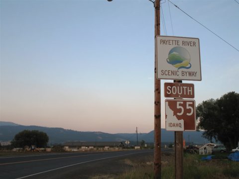
The southbound beginning of Idaho 55 at its junction with U.S. 95 in New Meadows. Idaho uses brown shields for both U.S. and State Highways when a scenic designation is applied.
By the time we reached U.S. 95, the sun was about to set for the day. We turned northward to Grangeville, grabbing some dinner at a local diner in Riggins. North of there is a tied-arch bridge of all things nestled within the canyon walls.
Once at Grangeville, we learned that all of the motel rooms in town were booked, so we had to continue another 20 miles or so along Idaho 13 to Kosskia where we found a vacancy for the night. All in all a long day, but with the early start, we saw most of what we wanted during the daylight hours with the exception of U.S. 95 north of Idaho 55…




THE FEDERAL GOVERNMENT CAN NOT GIVE STATES A SHARE OF THE FEDERAL GAS TAX MONEY IN ANY AMOUNT TO MAINTAIN THE INTERSTATE HIGHWAY SYSTEM THAT IS IN PLACE. HOW IN THE WORLD CAN THE FEDS HELP MAINTAIN A HIGHWAY SYSTEM OF THE SCOPE. IF THIS SYSTEM IS BUILT, IT BASICALLY PUTS IN PLACE THE IDEA OF A NORTH AMERICAN UNION. I, FOR ONE DO NOT WANT A UNION WITH MEXICO. MEXICO WILL NOT OR CANNOT TAKE CARE OF THEIR OWN. THE START OF THIS UNION WILL COME WITH THE PASSAGE OF THE DREAM ACT. ANY CONGRESSMAN, SENATOR THAT VOTES FOR THE DREAM ACT SHOULD BE RUN OUT OF OFFICE. BACK TO THIS HIGHWAY SYSTEM – I OPPOSE THIS TYPE OF TRANSPORTATION SYSTEM, JUST FOR THE LAND IT WILL USE UP. THAT IS VERY WASTEFUL.
I HAVE ONE SMALL QUESTION, IF YOU WERE GOING TO MONTANA, WHY DID YOU GO THRU OREGON AND IDAHO TO GET THERE? DIDN’T YOUR ROAD MAP SHOW YOU THAT I-90 WAS THE MOST DIRECT ROUTE FROM SEATTLE? ALSO YOU WERE WARNED ABOUT I-405 ANYTIME, EASTGATE SHOULD HAVE A PARK AND RIDE SOMEWHERE CLOSE TO I-90. ANOTHER NOTE SNOQUALMIE PASS HAS SNOW FOR SKIERS MAX 5 MONTHS A YEAR, THE ROAD IS MOSTLY CLEAR OF SNOW FROM APRIL THRU NOVEMBER, WHICH COINCIDES WITH CHAIN SEASON.
WHY DO YOU NEED MODERATION TO MY COMMENTS, WHEN WHAT I SAID IS TRUE. FURTHER, I-90 AT SNOQUALMIE PASS EASTSIDE HAS BEEN SCHEDULED FOR MAJOR IMPROVEMENTS – IT IS SSCHEDULED TO BEGIN IN 2010? HOW MANY MORE PEOPLE WILL DIE BEFORE THE STATE OF WASHINGTON DOT GETS ON THE BALL AND GETS IT DONE?