
The second day of our marathon drive continued us northeast into the Treasure State of Montana, my first visit there, and then back west via Interstate 90 to Seattle. A bout of allergies made life difficult through Boise, but the sleep I got in Kooskia all but removed the effects of that!
We resumed our journey along Idaho 13 north to U.S. 12 east for the eastward trek into Montana. U.S. 12 is considered a scenic route throughout its routing in Idaho, so signs are all coloured brown (shades of the old Florida days, I tell you!). The road lives up to its scenic designation, paralleling the Lochsa River from Lowell east to McConell Mountain and Lolo Pass. Surprisingly, the road moves fast and passing opportunities are available more than you would think.
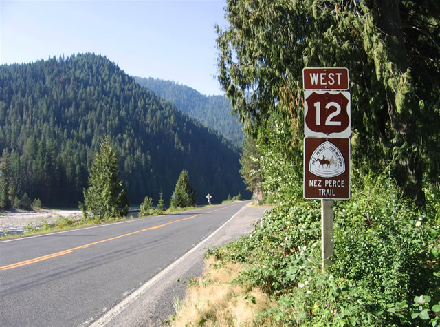
Westbound reassurance shield for U.S. 12 posted at the settlement of Lowell. The Lochsa River flows into the Clearwater Middle Fork river at Lowell. U.S. 12 parallels the waterway west to Kooskia and Kamiah.
At the Montana state line, which occurs at Lolo Pass (elevation 5,235 feet) is the Lolo Pass Visitor Center and Lewis and Clark Interpretive exhibit. The facility doubles as a welcome center for both states, and we were able to obtain official state maps for both Idaho and Montana there. Once U.S. 12 enters Montana, the road straightens somewhere and a generous 70 mph speed limit ensues. Much to my surprise, we encountered several tractor trailers using the road as a through route.
U.S. 12 descends to its merge with U.S. 93 at Lolo. The two highways join together along a four-lane highway northward to the city of Missoula, which is the home of the University of Montana. Missoula sees U.S. 12 and 97 split, with each highway having a Business Loop to boot. The city overall acts as a regional economic hub with your typical array of strip malls, fast food chains, car dealerships, etc. on the south side. Downtown lies adjacent to the Univ. of Montana campus, and the main streets reflect that spatial relationship with a wide array of businesses and residences. Missoula bustled on our visit to the city with college students and visitors alike.
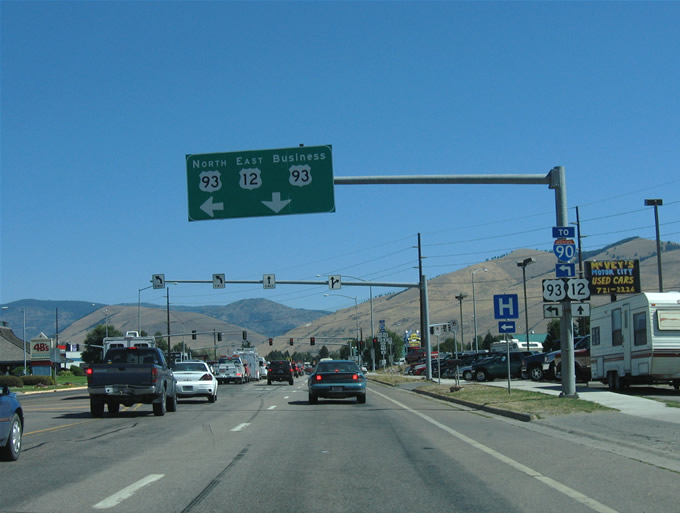
U.S. 12 east parts ways with U.S. 93 north on the south side of Missoula. U.S. 93 follows a newer bypass route to the west, while original U.S. 93 carries the Business loop moniker with U.S. 12 into downtown. The U.S. 93 bypass is not access-controlled, so businesses and other structures line the route.
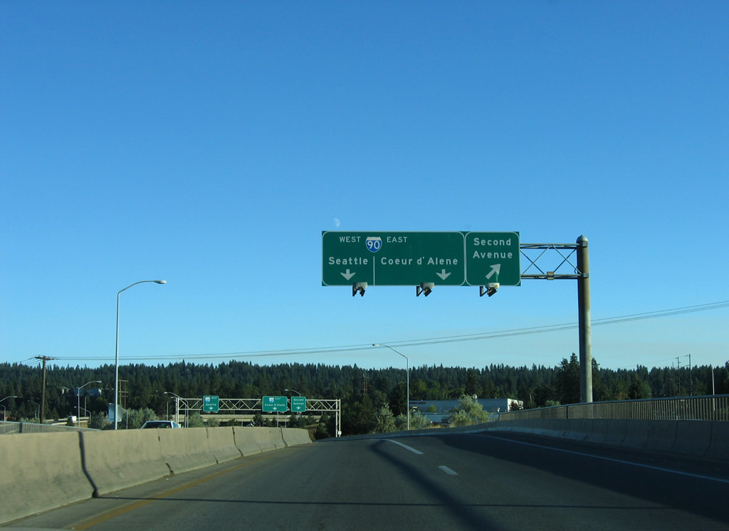
Business Loop Interstate 90 cuts a swath through downtown along Broadway Street. Although the route may be officially decommissioned, signs are still in place along the entire routing. Just north of the city the land rises in the form of mountains. A Union Pacific Railroad line and the Interstate 90 freeway segregate the city from the hillside.
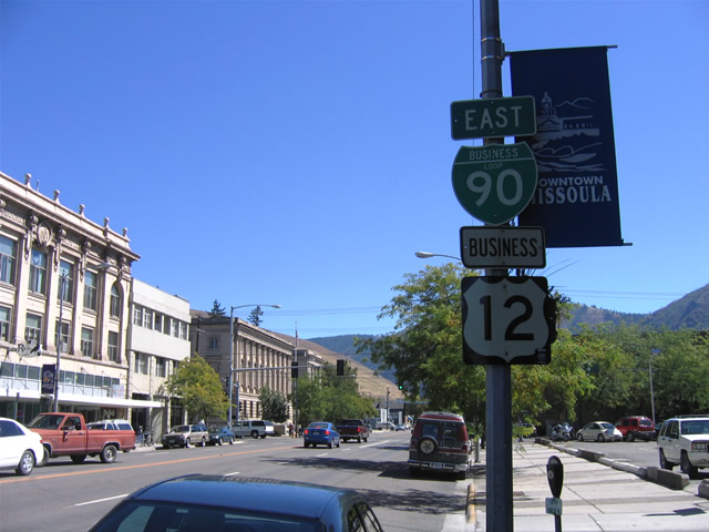
Business Loop Interstate 90 and U.S. 12 Business merge at the intersection of Broadway Street and Higgens Avenue in downtown Missoula. Here we look east at a reassurance shield assembly on Broadway Street as it heads toward Interstate 90 Exit 105. The University of Montana campus lies just southeast of downtown.
Montana is as they say, Big Sky Country. Our trip justified that nickname with crystal clear deep blue skies on the drive west to Idaho. Interstate 90 was lightly traveled and was one of the smoother freeways we encountered in the Pacific Northwest. Speed limits are set at 75 mph, and we averaged 75-80 along with everyone else.
Along most of Interstate 90 in western Montana are parallel alignments of old U.S. 10. Interstate 90 replaced U.S. 10 completely from Billings west to the Seattle area, however many of the old sections remain in use as Interstate Business loops (even though those also are falling by the wayside).
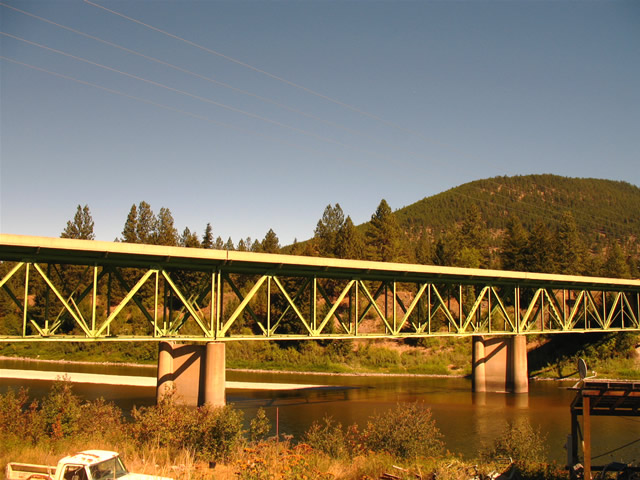
We spotted this old U.S. 10 bridge spanning the Clark Fork river at St. Regis (Exit 33 of Interstate 90). The old alignment spurs east to Four Mile Road, which just loops back to old U.S. 10 near this bridge. Montana 135 provides the only route out of town outside of the freeway.
One of the last undivided sections of Interstate highway is no more as widening of Interstate 90 on its trek through Lookout Pass is complete. The drive is still dramatic however, with a fast descent to Mullan some six miles west of the state line. There lies one of a handful of remaining business loops for Interstate 90 in Idaho.

At 4,680 feet, Lookout Pass represents the Montana and Idaho state line along Interstate 90. The boundary also represents the edge of the Mountain and Pacific Time Zones. For Interstate 90 westbound motorists, a 6% grade carries drivers downward over the next five miles to Mullan.
At Wallace, one of, in my humble opinion, the more interesting facets of Interstate history lies. Dubbed “the last traffic light on Interstate 90”, the signal at the intersection of Business Loop I-90 (Bank Street) at 6th Street remains in place in a permanent flash cycle. The town was bypassed by a sleek modern viaduct just north of downtown in 1991. A ceremony was actually held to bury the last traffic light hindering Interstate 90’s free flow across the country. However signals still hang on span wires in the heart of town.
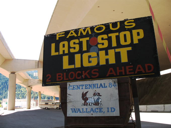
A sign attached to a small wagon in Wallace directs drivers on Business Loop I-90 westbound into the heart of town where the famous last I-90 stop light remains in place. The sleek peach colored viaduct carries four lanes of Interstate 90 overhead.
All Idaho business loops for Interstate 90 west of Osburn were decommissioned in 2005 with the exception of the one at Post Falls. Signage, for the most part, was altered to reflect the loop removals. At Coeur d’Alene, the largest city of northern Idaho, Interstate 90 straddles the scenic Coeur d’Alene Lake ahead of the city center. If you think that sprawl cannot penetrate far northern Idaho, you are sadly mistaken, as Coeur d’Alene and Post Falls are undergoing tremendous growth, and the traffic along Interstate 90 definitely reflected that.
I am unclear if Coeur d’Alene generates enough job and industry to consider itself independent of the much larger Spokane to the west. The close proximity however may relegate the city to bedroom community status to the eastern Washington city. Bedroom community status most certainly applies to Post Falls however with regards to Spokane, but perhaps also its neighbor to the east. Nonetheless all three cities are substantial for the placement in the far northwest Rockies.
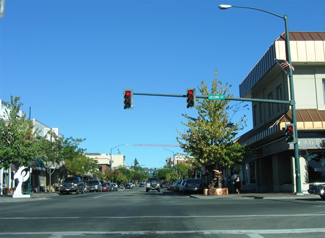
Sherman Avenue eastbound at 2nd Street in downtown Coeur d’Alene.
Sherman Avenue and 15th Street represent the historical path of Business Loop Interstate 90 through town. However as of 2006, all signs were removed of the designation. The city otherwise is gaining condo high rises of all things. Two were already in place along Sherman Avenue to the west of downtown, and the tall crane in the background here is in place to construct a third high rise.
Interstate 90 maintains just four lanes through the Coeur d’Alene and Post Falls area, but the freeway widens to six lanes through metro Spokane. Spokane itself looks like an older city with older high rise buildings and a more established suburban expansion. The commuting axis appears to be based upon U.S. 2 & 395 (Division Street) rather than Interstate 90. If that is the case, it is definitely a departure from the norm (see Boise and Tucson as good cases in point).

U.S. 2 east & 395 north (Division Street) northbound on the approach to Bridgeport Avenue in Spokane. The tandem follow Interstate 90 east into Spokane through to Exit 281. Division Street carries the highways north from there six miles to their split at Newport Highway.
While in town, we picked up a friend of Chris’s in north Spokane, and that took us upon Division Street for a few miles. The four to six-lane arterial teems with traffic and well established businesses and other structures. For the growing traffic woes that occur along the north-south road, WSDOT is building a new freeway for U.S. 395 to the east. Upon completion, the North Spokane Corridor (NSC) freeway will join Interstate 90 with U.S. 395 north of its split with U.S. 2 near Mead. This will alleviate traffic on Division Street for commuters between downtown and Spokane Valley to the north.
Spokane’s other freeway? Well technically it acts like a glorified off-ramp, but a short section of freeway joins Exit 282 with Washington 290 (Trent Avenue) between Interstate 90 and eastern reaches of the downtown area. For those curious about the numbering, it is not a failed Interstate 290, but rather Washington 2-90 as it relates to U.S. 2(-90). Washington, like South Carolina, uses a state road numbering system that implies loops and spurs from parent routes. So instead of South Carolina 762, it is technically South Carolina 7-62. This is why there are so many highways in the Washington 500 series.
Traveling south on the freeway connector between Washington 290 (Trent Avenue) and Interstate 90. A half-diamond interchange along the short freeway serves Second Avenue.
The other Spokane area freeway carries U.S. 2 to Spokane International Airport from Interstate 90.
The sun set on us earlier that I had hoped, claiming our daylight by the time U.S. 395 splits from Interstate 90 west at Ritzville. Twilight carried us west to the magnificent Columbia River valley at Vantage. There we stopped at a view point and gazed at the deep valley below where Interstate 90 spans the Columbia along a four-lane cantilever span.
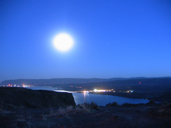
With the stars and moon overhead, Interstate 90 descends in dramatic fashion into the Columbia River valley at the town of Vantage. The Columbia flows south from British Columbia to the Tri-Cities before turning west along the Oregon and Washington border to the Pacific.
The rest of the drive was done in darkness, but we did note that only the Moses Lake Business Loop for Interstate 90 remains signed along the Interstate 90 mainline. However we did receive reports since then that the one in Cle Elum is still kicking outside of the freeway. Otherwise the drive west over the Cascades was amazing in that the Labor Day rush of traffic eastbound resulted in a 3o miles of traffic congestion well outside of the Seattle metro area. Our drive was relatively easy fortunately.
After we parted ways with Chris and Curt, we traveled south to Olympia, covering the suburban Washington 167 and 512 freeways on the way. Both roads were underpowered with just four lanes overall and an occasional six-lane section with auxiliary lanes. Without daylight, we gathered that both were rather nondescript. Day 8 took us around downtown Olympia and then south to Portland International Airport.


