
Interstate 15

Interstate 15 travels 393.030 miles from the Idaho state line at Monida Pass to Alberta, Canada at Sweet Grass. Connecting three of the top six most populated metropolitan areas in the state, I-15 connects the Rocky Mountains with western reaches of the Great Plains as both a freight corridor and travel route for tourists headed to Glacier National Park.
Interstate 15 Montana Guides
North

Idaho to Dillon - 70 photos
Dillon to Butte - 72 photos

I-15/90 East - Butte - 27 photos
Butte to Boulder - 58 photos
Clancy to Helena - 47 photos
Craig to Cascade - 67 photos
Great Falls to Power - 46 photos
Dutton to Conrad - 45 photos
Shelby to Sweet Grass - 68 photos
South
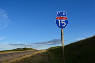
Sweet Grass to Shelby - 49 photos
Business Routes

Business Loop I-15 - Shelby - 48 photos
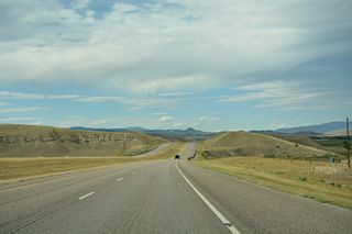
Entering the Glacier State from the south, I-15 crosses the Continental Divide into Beaverhead County. The lightly traveled freeway curves northwest into a broad valley fed by the Red Rock River east of the Tendoy Mountains and north to Clark Canyon Reservoir. Turning back to the northeast, Interstate 15 parallels old U.S. 91 and the Beaverhead River to the east to an agricultural area spreading south of Dillon. Dillon represents the first traveler services since Idaho and the first Business Loop for I-15 in the state.
Heading north from Dillon, I-15 passes through another agricultural area before climbing along a series of hills to the Big Hole River east of Sugarloaf Mountain and west of Bell Peak. Old U.S. 91 remains to the west as a through route to Melrose along the Big Hole River while the freeway rides along the hillside to the east. Crossing into Silver Bow County, which merged with the city of Butte to form a consolidated government in 1977, Interstate 15 winds between Old Glory and Goat Mountains to Montana 43 at Divide.
I-15 enters the Butte area east of Deerlodge National Forest and Fleecer Ridge. A trumpet interchange joins the freeway with Interstate 90 by Nissler, with the two combining east to Rocker, Williamsburg and the south side of Butte. Interstate 115 forms a short spur to Montana Street, which leads Business Loops I-15 & 90 north to Downtown Butte. The main commercial strip for the city lines Harrison Avenue and Montana 2 leading south from Floral Park, just west of where I-15 splits with I-90 east for the continuation north toward Helena and Great Falls.
Interstate 15 Corridor - 1968
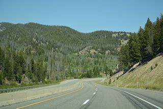
Interstate 15 rises in elevation to Elk Park Pass, where the freeway again crosses the Continental Divide. A southbound view area provides a look at Butte and the massive Berkeley Pit quarry. I-15 otherwise advances north through Elk Park valley east of Rampart and Sheepshead Mountains.
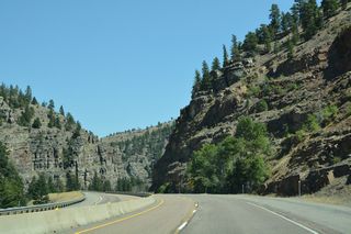
A winding stretch takes I-15 north through Bison Canyon and Deerlodge National Forest to Indian Head Rock and Basin. The route turns east-west along this stretch as it straddles the Boulder River before emerging above agricultural areas of Boulder Valley. Resuming a northward heading, I-15 winds across the Boulder Hills to Jefferson City and Clancy before crossing the Lewis and Clark County line and descending into the capital city of Helena.
The bulk of Helena spreads west of I-15, with the freeway combining with U.S. 287 north from U.S. 12 (Prospect Avenue) by Helena Regional Airport (HLN). A poorly signed business loop also serves Helena as it follows a number of streets by the state capitol building and through Downtown.
I-15/U.S. 287 bee line northward across farm and ranch land west of Lake Helena to Sawmill Gulch, where the tandem ascend between Cooper Butte and Rattlesnake Mountain. Long straight aways take the freeway northwest through Hilger Valley ahead of the narrowest stretch in the state, where I-15 parallels Little Prickly Pear Creek north from Sieben to Wolf Creek.
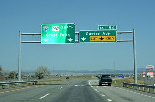
U.S. 287 branches west to Augusta and its northern terminus at Choteau while Interstate 15 angles northeast along the Missouri River to Cascade, Ulm and the city of Great Falls. Circling around the west side of Great Falls, I-15 sees for exits for the largest city in northern Montana. I-315, a short freeway spur signed as part of Business Loop I-15, U.S. 89 and Montana 3 & 200, provides a direct route to the main commercial district of the city.
Progressing northwest from Great Falls, U.S. 89 and MT 200 accompany Interstate 15 to Vaughn as the three highways parallel the Sun River. I-15 then turns more northward, traversing the edge of a plateau east of Muddy Creek and south of the Teton County line. The remainder of the route north travels generally across open ranch land and oil and gas fields with long sight distances. Business loops provide access to the larger population centers of Conrad and Shelby. Interstate 15 ends at a port of entry linking Sweetgrass with Couts, Alberta and Highway 4 leading north to Lethbridge.

S-276 begins north at the roundabout interchange (Exit 122) joining I-15/90 with Grizzly Trail, Nissler Road and Browns Gulch Road at Rocker in Butte.
08/09/16

I-15 south and I-90 west separate 0.9 miles west of S-276 (Browns Gulch Road) for Idaho Falls, Idaho and Missoula respectively.
08/09/16

Construction in 2019 replaced the five point intersection joining S-276, Browns Gulch Road and the westbound ramps from I-15/90 with a roundabout.
08/09/16

A six-leg roundabout joins S-276 (Browns Gulch Road) south with W Browns Gulch Road and the westbound ramps along I-15/90 at Rocker in Butte.
08/09/16

Northbound I-15 combines with I-90 east for 7.56 miles from near Rocker to near the Floral Park neighborhood in Butte.
08/09/16

S-276 ends at the exchange with I-15/90 at Exit 122. Grizzly Trail and Nissler Road tie in from the south.
08/09/16

Potter Road stems one mile west from Oilmont South Road in rural Toole County to meet Interstate 15 at Exit 373.
08/08/16

Swayze Road meets Interstate 15 at a rural diamond interchange (Exit 385) near Ohio Camp in Toole County.
08/08/16

Middle Butte of the Sweet Grass Hills rises along the eastern horizon from Swayze Road east at the northbound entrance ramp for Interstate 15 to Lethbridge, Alberta.
08/08/16

Interstate 15 trailblazer posted along the east freeway Frontage Road south at Swayze Road.
08/08/16

Swayze Road west at Interstate 15.
08/08/16

Border Road leads west from Railroad Street past the USDA Animal Inspection Station into a folded diamond interchange (Exit 397) with the north end of Interstate 15 at Sweet Grass.
07/06/16
Border Road west becomes Montana Secondary Highway 214 (3rd Avenue) at Interstate 15 and ahead of 2nd Street to he southbound entrance ramp for Shelby and Great Falls.
08/08/16
The Sweet Grass Rest Area and Montana welcome center lie nearby within the loop ramp joining the southbound beginning of Interstate 15 with SR 214 at 2nd Street and Loop Road.
08/08/16
07/06/16

S-214 turns west onto Loop Road from 2nd Street at the entrance ramp for Interstate 15 south. S-214 continues 32.67 miles to S-213 near Santa Rita.
07/06/16
The driveway to the Sweet Grass Rest Area ties into the intersection of 2nd Street north, Loop Road west and Interstate 15 south.
07/06/16

S-214 follows Loop Road east from Hillside Colony to the folded diamond interchange (Exit 397) joining Interstate 15 with 2nd Street at Sweet Grass.
07/06/16

S-214 makes an unmarked turn east onto 3rd Avenue across Interstate 15 from 2nd Street north into Sweet Grass.
08/08/16

S-214 northbound ends along 3rd Avenue at Interstate 15 adjacent to the Canadian Customs Station.
07/06/16

A loop ramp joins 3rd Avenue with the north end of Interstate 15. Alberta Highway 4 extends northwest from Coutts to Lethbridge.
07/06/16

Interstate 15 shields posted for the Sweet Grass Rest Area at the intersection with 2nd Street and Loop Road (S-214) in Sweet Grass.
08/08/16

The Sweet Grass Rest Area
08/08/16
Photo Credits:
- ABRoads: 08/08/16, 08/09/16
- Alex Nitzman: 07/06/16
Connect with:
Page Updated Monday February 02, 2026.