South

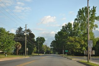
CR 165 (Basswood Road) merges with SR 71 south just inside the town of Greenwood.
04/16/12

CR 162 (Fort Road) east and SR 69 north come together at a traffic light with SR 71 (Bryan Street) in the Greenwood business district.
04/16/12

SR 69 extends Fort Road east from SR 71 and CR 162 to the settlement of Two Egg. The state road forms a 31.63 mile loop east from SR 71 to Grand Ridge and Blountstown.
04/16/12

SR 71 proceeds eight miles south from SR 69/CR 162 in Greenwood to U.S. 90.
04/16/12

SR 166 constitutes a 5.05 mile loop west from SR 71 to Florida Caverns State Park and south to U.S. 90 and SR 73 in Downtown Mariana.
04/16/12

SR 166 heads south across the Chipola River to Chipola College in the city of Marianna.
04/16/12

SR 71 south of SR 166 (Caverns Road) west.
04/16/12

CR 164 (Blue Springs Road) converges with SR 71 west from Dellwood. The intersection between the two routes was expanded with traffic lights by 2018.
04/16/12

SR 71 advances southwest from CR 164 (Blue Springs Road) to U.S. 90 outside Mariana.
04/16/12

Pelt Street ties into SR 71 just ahead of the wye intersection with U.S. 90.
04/16/12

04/16/12

SR 71 curves south to overlap with U.S. 90 for 1.6 miles.
04/16/12

U.S. 90 travels west to Downtown Mariana. SR 71 combines with U.S. 90 east before resuming south to Interstate 10.
04/16/12

East

South

05/01/09

Grand Ridge lies 12 mile east along U.S. 90, followed by Tallahassee in 68 miles.
05/01/09

U.S. 90/SR 71 cross Spring Creek / Merritts Millpond ahead of this reassurance shield.
05/01/09

SR 71 splits with U.S. 90 east along a four lane highway south to Interstate 10.
05/01/09

05/01/09

South

Interstate 10 parallels U.S. 90 two miles south of the split with SR 71.
10/05/16

10/05/16

Whitetail Drive ties into SR 71 at one of two signalized intersections along the commercial stretch leading south to Interstate 10.
12/31/06

SR 71 meets Interstate 10 at a diamond interchange (Exit 142).
10/05/16

Interstate 10 constitutes a rural freeway west from SR 71 to Crestview and Pensacola and east to Quincy and Tallahassee.
10/05/16

12/31/06

12/31/06

07/03/09

07/03/09

10/13/16

10/13/16

10/13/16

Continuing south from CR 278 (Alliance Road) and the settlement of Sink Creek.
07/03/09

07/03/09

07/03/09

07/03/09

07/03/09

CR 274 meanders southwest from Altha across the Chipola River en route to SR 73 at Chason.
07/03/09

07/03/09

06/27/09

06/27/09

CR 275 branches southwest from SR 71 ahead of a distance sign eight miles north of Blountstown.
12/31/06

Entering Blountstown, SR 71 curves east along Main Street N.
07/03/09

Main Street N at Charlie Johns Street in Blountstown.
12/31/06

SR 71 turns southward ahead of Evans Avenue and SR 69.
07/03/09

State Road 69 loops east from SR 71 between Blountstown and Greenwood via Grand Ridge.
07/03/09

SR 71 continues south from SR 69 to Downtown Blountstown.
06/27/09

SR 20 follows Central Avenue across Blountstown.
06/27/09

The western branch of SR 20 extends from Tallahassee to Bristol, Blountstown, Ebro, Freeport and Niceville.
06/27/09

Confirming marker for SR 71 south of SR 20 on S Main Street.
06/27/09

The city of Wewahitchka lies 27 miles south of Blountstown.
06/27/09

SR 71 splits from S Main Street beyond Sherry Avenue in Blountstown.
06/27/09

SR 71 spans Sutton Creek beyond S Main Street.
06/27/09

CR 69 branches south from SR 71, 10.06 miles to New Hope and CR 275 south of Juniper Swamp.
01/16/16

A separate branch of CR 69 spurred west from SR 71 along Barfield Road.
01/16/16

This shield was date stamped 10-05-77, and the arrow 03-20-72.
06/27/09

SR 71 bee lines southwest from CR 69 and Barfield Road to a residential area at Grace Peacock Road north and Faircloth Road west.
01/16/16

Long straightaways take SR 71 through timberland east of Bullhead Swamp.
06/27/09

06/27/09

The 14.79 mile route of County Road 275 returns to SR 71 south of Abe Springs.
01/16/16

06/27/09

The lone shield for CR 275 north on SR 71 south was removed after 2009.
01/16/16

06/27/09

The southern branch of County Road 275 arcs 3.13 miles southeast from SR 71 to CR 69 and SE Cox Fish Camp Road ahead of this reassurance marker.
06/27/09

Curving southwest, SR 71 reaches the settlement of Scotts Ferry.
01/16/16

SR 71 spans the Chipola River at Scotts Ferry.
01/16/16

County Road 392 stems 9.66 miles west from SR 71 to SR 73 north of Kinard and Broad Branch.
01/16/16

SR 71 spans Cypress Creek across the Sweetwater Bridge.
01/16/16

CR 73A (Oak Grove Road) west and SR 73 south converge with SR 71 at the settlement of Chipola Park.
01/16/16

SR 73 follows a rural course 15.60 miles north to SR 20 at Clarksville.
01/16/16

SR 71 at the south end of SR 73. SR 73 travels north to Mariana and U.S. 231 northeast of Cottondale.
01/16/16

01/16/16

01/16/16

01/16/16

Crossing West Arm Creek, SR 71 enters the city of Wewahitchka.
01/16/16

01/16/16

Continuing into Wewahitchka, SR 71 shifts west at 2nd Street by Lake Alice to intersect the east end of State Road 22.
01/16/16

SR 22 joins northern Gulf County with the Panama City area along a 25.85 mile route between SR 71 and U.S. 98 Business at Springfield.
01/16/16

CR 22 spurs 5.29 miles east from SR 71 along Lake Grove Road to Gaskin Park at the intersection adjacent to SR 22 west.
11/27/06

Leaving Wewahitchka, SR 71 approaches County Road 386 south.
11/27/06

CR 386 travels southwest to Overstreet and U.S. 98 along the east side of Mexico Beach.
11/27/06

White City lies 16 miles south of CR 386 along SR 71 at the Intracoastal Waterway.
11/27/06

CR 381 spurs southeast from SR 71 at Gaskins Still.
10/30/10

CR 381 runs 9.33 miles south to Dalkeith and Willis Landing.
10/30/10

Gulf County Road 381A constitutes a 1.20 mile connector between SR 71 and CR 381 at Dalkeith.
11/27/06

11/27/06

SR 71 bee lines southward to Whitfield Hill.
11/27/06

CR 387 (Doc Whitfield Road) spurs 8.69 miles east to the community of Howard Creek.
11/27/06

White City is 1.5 miles south of CR 387 on SR 71.
11/27/06

Approaching the Intracoastal Waterway bridge on SR 71 southbound.
11/27/06

The Gulf Intracoastal Waterway represents the boundary between Central and Eastern Time Zone.
11/27/06

The Intracoastal Waterway ties into the Gulf County Canal west of White City.
11/27/06

CR 382 (Industrial Road) provides a cutoff from SR 71 to the north side of Port St. Joe.
11/27/06

06/27/09

Curving west, SR 71 expands into a four lane boulevard at the Port St. Joe city line.
11/27/06

SR 71 is Cecil G. Costin, Sr. Boulevard in Port St. Joe.
11/27/06

State Road 71 concludes at U.S. 98 (Monument Avenue) on the south side of Downtown Port St. Joe.
11/27/06

U.S. 98 travels southeast from Port St. Joe to Apalachicola and northwest to St. Joe Beach and Mexico Beach.
06/27/09

06/27/09
Page Updated Tuesday April 14, 2020.

 South
South


 East
East  South
South South
South


