
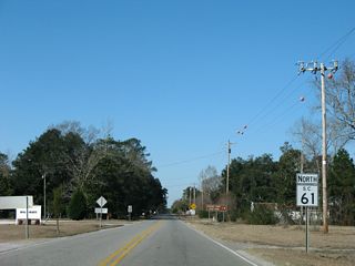
South Carolina Highway 61 travels 67.05 miles southeast from U.S. 78 near Farrell Crossroads in eastern Bamberg County to S.C. 30 (James Island Expressway) in the city of Charleston. S.C. 61 follows a linear route paralleling the Edisto River to U.S. 15 (Jeffries Highway) at Canadys and Givhans Ferry State Park in Dorchester County. Continuing through the LowCountry, S.C. 61 combines with U.S. 17 ALT for 0.40 miles at The Forks and meets S.C. 165 at Cooke Crossroads.
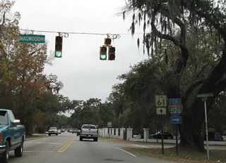
Following the Ashley River to the west, S.C. 61 south of S.C. 165 is part of the Ashley River National Scenic Byway. The state highway advances into suburban areas of Charleston including West Ashley, eventually converging with U.S. 17 and S.C. 30 near Downtown.
Historically S.C. 61 only extended northwest to U.S. 78 at Summerville. This changed by 1967, with S.C. 61 realigned to overtake what was S.C. 65 west to U.S. 15 at Canadys and U.S. 78 west of Branchville. A portion of the old route into Summerville was redesignated as S.C. 165.
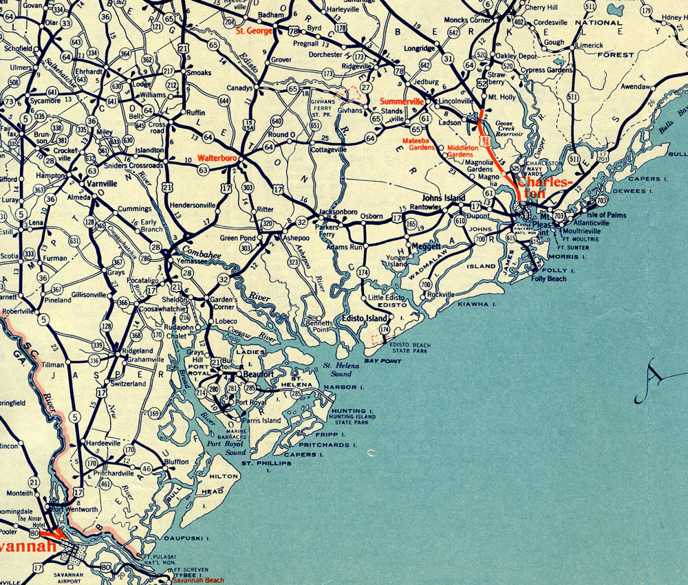
S.C. 61 between Summerville and Charleston in 1942.


U.S. 17 ALT diverges southwest to Cottageville while S.C. 61 arcs northward to Coachmans Corners.
11/13/06


S.C. 61 branches northwest from U.S. 17 ALT along the Clement Singleton, Sr. Highway 8.00 miles to Givhans Ferry State Park.
01/03/08

S.C. 27 runs 19.51 miles northeast to Ridgeville, I-26 near Pringletown and U.S. 176 between Sandridge and Dean Swamp.
01/03/08

Peirce Road (Road 35) heads 9.04 miles southwest from S.C. 61 to Red Oak Corner and U.S. 17 ALT in the town of Cottageville.
01/03/08

S.C. 651 (Rehoboth Road) runs 8.27 miles south from S.C. 61 to U.S. 17 ALT (Cottageville Highway) in Cottageville.
01/03/08

Sidneys Road (Road 21) angles 11.09 miles southwest to Sidney and U.S. 17 ALT outside Walterboro.
01/03/08

Upcoming U.S. 15 (Jefferies Highway) originates 11.16 miles to the south from U.S. 17 ALT in Walterboro.
01/03/08

U.S. 15 (Jefferies Highway) continues 9.66 miles north to U.S. 78 at Parler Avenue and Memorial Boulevard in the town of Saint George.
01/03/08

Removed after 2008, a second trailblazer for Interstate 95 was posted along S.C. 61 (Augusta Highway) north ahead of Redbank Drain in Canadys.
01/03/08

S.C. 61 (Augusta Highway) converges with Interstate 95 at a diamond interchange (Exit 68) just south of the Edisto River.
01/03/08
![]() |
S.C. 217 (Sunrise Road) stems 6.88 miles west from S.C. 61 (Augusta Highway) near Springtown to U.S. 21 in the town of Smoaks. 01/03/08 |
The previously rural intersection with S.C. 165 was expanded in 2014/15 with turn lanes and additional lanes along both state highways. 12/15/07 |
S.C. 61 continues southeast from Cooke Crossroads along the Ashley River National Scenic Byway. 12/15/07 |
Points of interest along Ashley River National Scenic Byway include Middleton Gardens, Magnolia Gardens and Plantation, and Drayton Hall. 12/15/07 |
S.C. 61 (Ashley River Road) runs between several subdivisions in western reaches of Charleston to Bees Ferry Road (Road 57). Bees Ferry Road is a four lane arterial angling southwest 4.55 miles to U.S. 17. 12/15/07 |
Magwood Road links S.C. 61 (Ashley River Road) with S.C. 461 in 0.78 miles. S.C. 461 runs west along Glenn McConnell Parkway and east along Paul Cantrell Boulevard to Interstate 526. 12/15/07 |
The reassurance marker south of Magwood Road is only the second for S.C. 61 posted south of S.C. 165 in Dorchester County. 12/15/07 |
There is no direct access between S.C. 61 (Ashley River Road) and Interstate 526. 12/15/07 |
Tobias Gadsden Boulevard arcs 0.33 miles south to S.C. 461 (Paul Cantrell Boulevard) east of the exchange with Interstate 526. 12/15/07 |
Raoul Wallenberg Boulevard heads 0.74 miles northeast from S.C. 61 to the Plantation Estates neighborhood and Ashley Hall Road. 12/15/07 |
S.C. 61 (Ashley River Road) next converges with the south end of S.C. 461 (Paul Cantrell Boulevard). 12/15/07 |
Savage Road intersects S.C. 61 (Ashley River Road) to the immediate south of S.C. 461. Savage Road arcs 1.86 miles southwest to U.S. 17 (Savannah Highway). 12/15/07 |
S.C. 61 meets S.C. 7 (Sam Rittenburg Boulevard) along a heavily developed commercial strip in West Ashley. S.C. 7 runs 5.92 miles northeast from U.S. 17 to U.S. 52/78 in North Charleston. 12/15/07 |
Wappoo Road (Road 26) stems 2.77 miles southwest from S.C. 7 to U.S. 17 at Dupont Station and Edgewater Park along the Stono River. 12/15/07 |
Ashley Hall Road south ties into S.C. 61 (Ashley River Road) by the Heathwood subdivision. 12/15/07 |
Road 520 is a 1.00 mile long collector along Playground Road and W Oak Forest Drive south from S.C. 61 to U.S. 17 (Savannah Highway). 12/15/07 |
Carriage Lane (Road 80) provides a cutoff 0.17 miles to S.C. 171 (Old Towne Road) north. 12/15/07 |
S.C. 171 (Old Towne Road) branches 1.59 miles south from S.C. 7 (Sam Rittenburg Boulevard) to Charles Town Landing State Historic Site and S.C. 61 at Maryville. 12/15/07 |
![]() ![]() |
S.C. 61/171 overlap 1.59 miles southeast to Wesley Drive. 12/15/07 |
S.C. 171 spurs 9.33 miles south from S.C. 61 (St. Andrews Boulevard) to Folly Beach. 12/15/07 |
![]() |
S.C. 61 elevates onto a flyover ramp spanning U.S. 17 (Savannah Highway) south beyond the exit for U.S. 17 across the T. Allen Legare Bridge into Downtown Charleston. 12/15/07 |
The second of two signalized intersections along the Herbert U. Fielding Connector joins S.C. 61 with Ashley Point Drive and Albemarle Road. 12/15/07 |
S.C. 61 concludes east of Ashley Point Drive at a trumpet interchange with S.C. 30 (James Island Expressway). 12/15/07 |
A 3.05 mile long route, S.C. 30 (James Island Expressway) spurs south from U.S. 17 (Spring Street) and Downtown Charleston to S.C. 171 (Folly Road) on James Island. The freeway was constructed in anticipation of Interstate 526. 12/15/07 |
Connect with:
Interstate 95
U.S. 15
U.S. 17
U.S. 17 Alternate
U.S. 21
U.S. 78
Highway 30 - James Island Expressway
Highway 217
Page Updated 12-05-2022.