
Historic U.S. 80

This replica U.S. 80 shield was fabricated using specifications set during the era when route markers had the California Department of Public Works, Division of Highways logo at the bottom of the six-point U.S. shield. Cat-eyes allowed for nighttime reflectivity of the numerical designation. - 06/18/2011
U.S. 80, the Broadway of America, used to follow the southern tier of California, connecting San Diego with La Mesa, El Cajon, Alpine, Boulevard, Jacumba Hot Springs, Mountain Springs, Ocotillo, Plaster City, El Centro, Holtville, Buttercup Valley, and Winterhaven. With the designation of Interstate 8 in 1964, U.S. 80 was phased out as segments of freeway bypassed the older U.S. 80 alignment. Many extant segments of former U.S. 80 are still in service today. The various business loops of Interstate 8 in California (serving San Diego/La Mesa, Alpine, El Centro, and Winterhaven/Yuma) all incorporate old segments of U.S. 80. The original auto trail that preceded U.S. 80 was known as the Bankhead Highway, and that name also referred to the U.S. 80 corridor in ensuing years.
Historic U.S. 80 California Guides
- East:
- San Diego - Market Street and Park Boulevard
- San Diego to La Mesa - El Cajon Boulevard
- El Cajon to Alpine and Viejas - Main Street, Highway 8 Business, Olde Highway 80, Alpine Boulevard, Willows Road
- Descanso Jct to Crestwood Summit via Pine Valley - Old Highway 80
- Crestwood to Jacumba Hot Springs - Old Highway 80
- Mountain Springs and Ocotillo to El Centro - Mountain Springs Road, Imperial County S-80 (Evan Hewes Highway)
- Holtville Hot Springs to Winterhaven
- West:
Before U.S. 80 was commissioned, it was part of several auto trails that constituted an all-weather, transcontinental highway (National Southern Highway). Motorist associations formed in the 1910s to advocate for the future U.S. 80 corridor. Then-future U.S. 80 in Southern California was known as part of the Ocean-to-Ocean Highway, the Bankhead Highway, the Lee Highway, the Old Spanish Trail, and the Dixie Overland Highway. Other named auto trails, such as Jefferson Davis National Highway, followed portions of U.S. 80 (including the Laguna Mountain segment but excluding the Imperial Sand Dunes segment). In later years, U.S. 80 became known as the Broadway of America. Portions of the auto trail opened between 1911 and 1915. Most of the original Laguna Mountains segments opened in 1911. The Mountain Springs Road opened in 1913. The bridge between Winterhaven and Yuma over the Colorado River opened on May 24, 1915. One of the most insurmountable obstacles was of the the Imperial (Algodones) Sand Dunes (also called the Sand Hills); the auto trail crossed over the shifting sands by way of the original, two-track Old Plank Road in 1915; a later improvement project resulted in a widened, eight-foot-wide Old Plank Road in 1916. The Old Plank Road was widened again in 1922 and bypassed by a more traditional paved road in 1926.4 Around this time, U.S. 80 came into existence to replace the various auto trail designations.
Replacing the auto trails along with dozens of other similarly commissioned routes as recommended by the Joint Board on Interstate Highways and approved via the American Association of State Highway Officials (AASHO), U.S. 80 was created in November 1926 and documented in April 1927 as one of the original U.S. highway routes. It originally extended across the country, connecting San Diego with Savannah, Georgia. It was extended east to Tybee Island in 1929.4 In California, U.S. 80 increasingly became important and was planned for replacement by Interstate 8 between San Diego and Gila Bend, Arizona. Legislatively, the state of California decommissioned U.S. 80 in 1964. However, another decade would pass before most U.S. 80 route markers were removed from California. By 1974, most of Interstate 8 was complete and could be linked together as a continuous route across the southern tier of California, so U.S. 80 lost importance as a regional and national corridor. As sections of U.S. 80 were bypassed by Interstate 8, signs started to come down. By 1974, the last signs for U.S. 80 disappeared along the Interstate 8 corridor in California.


A ceremony held on October 21, 2006 in Seaport Village celebrated the designation of the old alignment of U.S. 80 in San Diego County as a historic route. The ceremony was held just south of the Harbor House at the Unified Port of San Diego's Embarcadero Marina Park North in the morning, and live coverage was provided on television by local station KUSI-TV Channel 9/51 and on-air personality Dave Scott. The planned festivities included a classic car rally that would follow Old U.S. 80 from Seaport Village to Viejas Casino.
A plaque commissioned at the event read:
You now stand at the end of a very long road. Born out of the muddy ruts of the first model T's, a 3,000-mile dream against insurmountable odds to connect east and west by automobile. They would call it U.S. Route 80. It spanned rugged mountains, bridged mighty rivers, crossed scorching deserts, and linked a growing nation. But what started in Savannah stopped in Phoenix. The roadblock was this: Should the final destination be Los Angeles or San Diego? A car race was held. The team to reach Phoenix first would win for their city, the final leg of the highway. On October 28, 1912, David Campbell and Edgar Harvey, in a Stevens-Duryea Racer, reached the finish line in just under 17 hours, two hours ahead of their L.A. rival. With San Diego on the map, U.S. Route 80 was finally commissioned in 1926. It was the first transcontinental highway in the U.S. In years since, U.S. Route 80 would come to be called the 'Broadway of America.
Both the plaque and prototype Historic U.S. 80 Route sign were prominently featured as various dignitaries remarked about the importance of U.S. 80 and the possible economic benefits of signing the historic route through the cities of San Diego, La Mesa, and El Cajon as well as the various unincorporated communities (such as Flinn Springs, Alpine, Descanso, Pine Valley, Boulevard, and Jacumba Hot Springs) along the mostly rural route in eastern San Diego County.
U.S. 80 still remains in use as a local road in most of San Diego County and Imperial County in Southern California. The old alignments carry names such as "Old Highway 80" and were signed with brown "Historic U.S. 80 Route" markers in October 2006. The disconnected segments, when linked together, used to be the primary route leading from San Diego on the coast with its suburbs (La Mesa, El Cajon, and Alpine) and then east into the Laguna Mountain communities of Pine Valley, Boulevard, and Jacumba Hot Springs. At In-Ko-Pah east of Jacumba Hot Springs, U.S. 80 descended into the Imperial Valley, with many old concrete sections still visible from Interstate 8. The old route then follows Imperial Cuonty Route S-80/Evan Hewes Highway east to Seeley, El Centro, and Holtville. Staying just north of Interstate 8 east of Holtville and just south of Interstate 8 through the sand dunes, Old U.S. 80 crossed the Colorado River on the still-standing 1915 Ocean-to-Ocean Highway bridge and entered Arizona from the small community of Winterhaven, leading into Yuma.
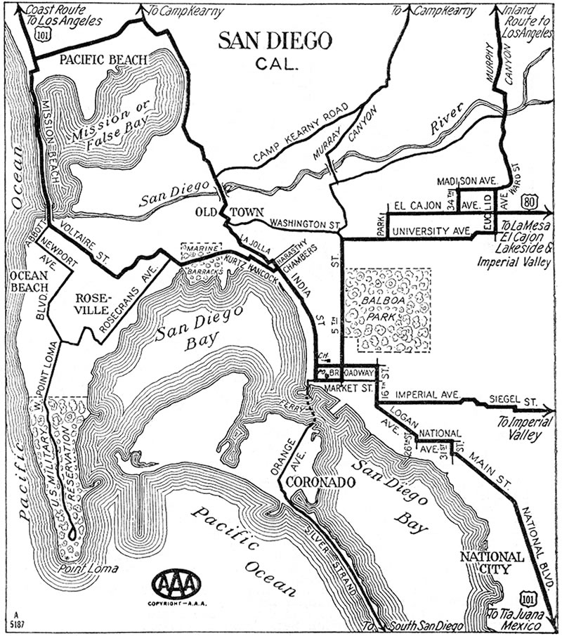
1933 AAA map of San Diego showing U.S. 80 south to Downtown along 5th Avenue (shown here as 5th Street).
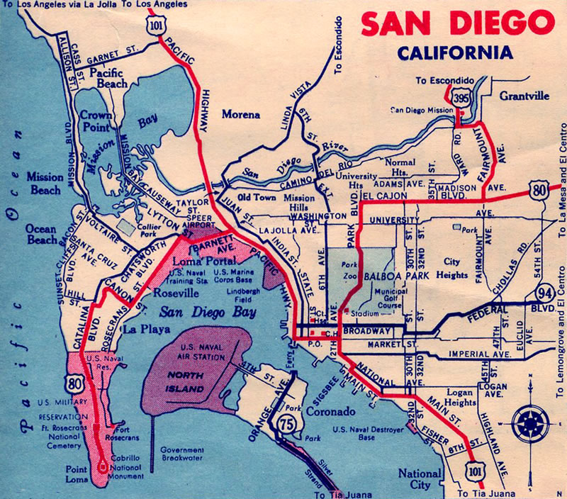
1940 Gousha Map showing U.S. 80 extended west to Point Loma
In the city of San Diego, U.S. 80 had several routes. In chronological order, U.S. 80 followed the several alignments through the city:1,2,3,4
- From U.S. 101/Broadway at Horton Plaza north along the 4th/5th Avenue couplet to University Avenue, then east on University Avenue to La Mesa (circa 1926-1930); a 1933 AAA map of San Diego showed the route of U.S. 80 via 5th Avenue.
- From U.S. 101/Market Street north along 12th Avenue (now Park Boulevard) to El Cajon Boulevard, then east on El Cajon Boulevard to La Mesa (circa 1930-1938)
- From Harbor Drive (Historic U.S. 101) near today's Grand Hyatt Regency hotel east along Market Street to 12th Avenue (Park Boulevard) north, then east on El Cajon Boulevard to La Mesa (this extension occurred due to the relocation of U.S. 101 onto then-new Harbor Drive) (1938 to 1947)
- Around 1940-1943, a possible extension of U.S. 80 was to carry the route from downtown San Diego northwest along Historic U.S. 101 (Pacific Highway) to Barnett Avenue, then west along Barnett Avenue, Rosecrans Street, Canon Street, and Catalina Boulevard to end at Cabrillo National Monument near the tip of Point Loma. This extension only appeared on Gousha maps during the World War II timeframe, and it is not clear whether U.S. 80 markers were ever placed on this alignment.
- From Harbor Drive (Historic U.S. 101) near today's Grand Hyatt Regency hotel east along Market Street to 10th/11th Avenue couplet north to the Cabrillo Freeway then east on Washington Street, Normal Street, and El Cajon Boulevard to La Mesa (1947 to 1953). The Cabrillo Freeway was constructed between 1942 and 1947.
- From Historic U.S. 101 (Pacific Highway) near Old Town east along the Mission Valley Freeway through Mission Valley toward La Mesa (June 1953-1964; this became Interstate 8, and U.S. 80 signs were gradually removed thereafter until 1974, when Interstate 8 was completed)
Many sections of U.S. 80 were constructed using Portland Cement Concrete, and they date back to the 1930s and earlier (in some rare cases, abandoned concrete dates back to 1917, just after the Old Plank Road and Ocean to Ocean Highway Bridge were opened to traffic in 1915). Several of these segments can be seen in San Diego and Imperial Counties as frontage roads, realigned curves, and old bridge approaches. Several other segments remain in use today, especially the long stretch of Old Highway 80 in eastern San Diego County through Jacumba Hot Springs that largely dates to the 1930s.
With the elimination of U.S. 80 in California by 1974, a much greater portion of U.S. 80 was later removed from the books nationally. The first segment to be decommissioned was U.S. 80 in western and central Arizona, from Yuma east to Benson on September 16, 1977 (per state Resolution 1977-16-A-048). AASHTO approved U.S. 80's removal between these points a little more than a month later, on October 28, 1977.4 This route was replaced by Interstate 8 (Yuma to Gila Bend), Arizona 85 (Gila Bend to Buckeye), Maricopa County 85 (Buckeye to Phoenix), Interstate 10 (Phoenix to Tempe), U.S. 60 (Tempe to Florence Junction), U.S. 89 and Arizona 79 (Florence Junction to Catalina), Arizona 77 (Catalina to Tucson), and Interstate 10 (Tucson to Benson). (U.S. 89 was decommissioned south of Flagstaff a few years later, on August 21, 1992, per state Resolution 1992-08-A-056.) Full elimination of U.S. 80 finally occurred in Arizona on December 15, 1989, when U.S. 80 from Benson to Bisbee and Douglas was replaced by Arizona 80 and New Mexico 80 (per state Resolution 1989-12-A-096). AASHTO had approved the retraction from Arizona and New Mexico on October 6, 1989 (from Benson, Arizona, east to New Mexico Route 48 in Anthony, New Mexico). The route was removed from New Mexico at the same time, replaced by New Mexico 80 and Interstate 10 from Lordsburg to El Paso.
On October 12, 1991, U.S. 80 from the New Mexico-Texas state line near El Paso east to Dallas was eliminated; many old segments of U.S. 80 through cities were renumbered as Interstate business loops simultaneously.4 That entire stretch -- save Arizona 77 between Tucson and Florence Junction and Arizona/New Mexico 80 between Benson and near Lordsburg via Douglas -- was replaced by Inter state routes, thus relegating the old highway to frontage road status in some areas or completely gone in others. In cities, many of the old alignments became business loops of Interstate 8, Interstate 10, or Interstate 20. Several other extant sections of Old U.S. 80 (the Broadway of North America) still remain, including several sections out of sight from the freeway. U.S. 80 today extends from Interstate 30 in Dallas, Texas, to an end at a monument located in Tybee Island, Georgia.4
The Old Plank Road
One of the most popular segments of predecessor roadway along the U.S. 80 corridor is the Old Plank Road, which was built across the Imperial (Algodones) Sand Dunes. This road was built in the hopes of directing travelers headed to the Pacific Coast to San Diego rather than Los Angeles, even though Los Angeles had already become the western hub of various railroads. Colonel Ed Fletcher, a San Diego booster, helped finance the proposed Plank Road, which was ensure a direct route from San Diego to Yuma and Phoenix.4, 5, 6
The first planks of the road were laid on February 14, 1915, and construction continued through that winter. The Plank Road officially opened to traffic two months later on April 4, 1915, over a distance of nearly six and a half miles. The first wave of motorists to cross the Plank Road in Spring 1915 was the "Glad Hand Excursion," which included 25 cars and approximately 100 people. The road was built initially as a two-track: Cars were to drive over the original Plank Road with each wheel on a pair of narrow, two-foot, one-inch wide planks laid side-by-side. Only one direction of traffic could proceed across the dunes at a time. Despite the limitations of the design, the Plank Road enabled road travel never conceived previously. With the opening of both the Plank Road and the Ocean to Ocean Highway bridge over the Colorado River between Yuma and Winterhaven in 1915, a true transcontinental automobile route was finally possible across the southern tier of the United States.
The Plank Road became a state highway in June 1915. In 1916, the state rebuilt the Plank Road with wooden cross ties laid to a width of eight feet with double-width turnouts every 1,000 feet. Maintenance was difficult due to wind-blown sand, shifting sand dunes, rough rides due to plank movement, and traffic jams due to the need to pull off to a turnout to allow opposing traffic to pass. Despite efforts to create a two-way plank road in 1924, it became clear that a permanent, paved road would be the best long-term solution for crossing the sand dunes. To that end, engineers determined that lower sand dunes moved rapidly, while other higher dunes moved more slowly. This meant that a road at a higher grade could be feasible. To that end, a new paved road opened on August 12, 1926, to replace the Plank Road.
While the Plank Road was never signed as U.S. 80, it plays a major role in the history of the cross country route and today is a California State Historical Landmark. The paved road is now a frontage road along the four-lane Interstate 8 freeway, which was also built to withstand the challenges of the shifting sand and desert environment.
Many thanks to the San Diego Automotive Museum for information about the Old Plank Road. A visit to the museum is a must for any old road or car enthusiast. Additional information comes from archived copies of the California Highways and Public Works magazine and Desert U.S.A. - Old Plank Road webpage.

A mural harkening back to the old days of Highway 80 is on the side of the Bekins Building at 3727 El Cajon Boulevard in the City Heights community of San Diego. It was painted in the span of week in early December 2009 by artists Werc Alvarez and Geraldine Lozano. The mural extends around to the front of the building; this view is looking west from the southern sidewalk along El Cajon Boulevard.
10/11/10

This blue and white style of street sign marks the intersection of El Cajon Boulevard and Esther Street in San Diego. Replacing older black-on-white and white-on-green signs, these signs were phased in across the city of San Diego through 2020.
03/27/05

This sign, which points the way to Julian via Historic U.S. 80 west and Mt. Laguna via Historic U.S. 80 east, is posted along northbound Pine Valley Road in the unincorporated community of Pine Valley.
10/14/06

This view looks northwest toward Laguna Summit as seen from the shoulder of Buckman Springs Road (San Diego County S-1). Old Highway 80 follows the power lines northwest toward Laguna Summit.
11/10/12

View of a bridge near Jacumba Hot Springs along old U.S. 80 in San Diego County as the highway passes over the San Diego and Imperial Valley Railroad. This railroad was in use as a freight line until around 1986; since then, the section between Campo and Plaster City has fallen into disuse. Plans call for this rail line to be refurbished and restored, but it is unclear when it might return to active service again. With steep grades, only a single track, and the section that enters into Mexico, this rail line is not likely to achieve the same level of traffic as many east-west railroads in California.
01/22/99

The U.S.-Mexico International Border in metropolitan San Diego is marked with a tall fence, one that is heavily guarded and difficult to surmount. This fence was extended east through rural San Diego County in phases through the 2000s.
01/22/99

Back in 1999, the international border was marked by a short fence, paralleled by the dirt road shown in these pictures. The vantage point is just south of U.S. 80 (Old Highway 80) near the railroad bridge west of Jacumba Hot Springs; the border is within walking distance from the south side of U.S. 80.
01/22/99

A side trip off California 79 onto Los Terrinitos Road reveals a rare, 1917 bridge that originally served the pre-U.S. 80 auto trail and later was incorporated into U.S. 80.
04/29/07

The underside of the Los Terrinitos Drive Bridge bridge with its cathderal-like substructure.
04/29/07

Los Terrinitos Bridge is a deck concrete arch bridge that spans the Sweetwater River.
03/12/05

This narrow, ornate bridge served as part of the principal east-west U.S. 80 route until 1951, when the taller, wider 1951 bridge was built along what is now Wildwood Glen Lane.
04/29/07

Plentiful water flowed through the Sweetwater River below the Los Terrinitos Bridge due to an unusually wet winter in 2004-05. Blackened trees nearby burned in the 2003 Cedar Fire.
03/12/05

A second side trip off California 79 onto Wildwood Glen Lane reveals a tall, 1951 bridge that originally was built to bypass the nearby Los Terrinitos Bridge and allow a faster passage over the Sweetwater River for U.S. 80.
03/12/05

Built high above the Sweetwater River, this bridge was intended to become part of the U.S. 80 high-speed route that was slowly being developed through the mountains.
04/29/07

The 1951 bridge spanning the Sweetwater River along old U.S. 80 was orphaned due to construction of Interstate 8. It is easily visited by bridge and highway enthusiasts.
04/29/07

Located by the intersection of California 79 and Wildwood Glen Lane just east of the 1951 Sweetwater River bridge, an abandoned stretch of twin-slab concrete remains along old U.S. 80 followed a curve connecting the bridge with the modern California 79 alignment.
04/29/07

East of Viejas Indian Reservation and west of California 79 near Descanso Junction, this old alignment of U.S. 80 is located along Wildwood Glen Lane in Cleveland National Forest. It has been closed off to vehicular traffic yet still has traversable, twin slab concrete poured in the early 1930s.
10/14/06

The walk from the dead-end of Wildwood Glen Lane is all downhill from Los Terrinitos Road to the point where the concrete ends. Much of this area burned during the Cedar Fire of October 2003.
10/14/06

This arch bridge, located adjacent to the Old Highway 80 crossing over Pine Valley Creek, was the original auto trail bridge over the creek. It was built in 1916 (some sources peg the opening date in 1917, just like Los Terrinitos Bridge over Sweetwater River east of here). While the bridge still stands, it is no longer in use and sits on private property, making access with property owner permission impossible.
03/12/05

A long stretch of abandoned, single-slab concrete that was originally built in the 1910s prior to the official commissioning of U.S. 80.
08/20/06

With the creation of U.S. highways in 1926, U.S. 80 was signed along this route until it was bypassed by a more modern asphalt highway that now carries Imperial County Route S-80 (Evan Hewes Highway). It is not clear when this rerouting happened; it was possibly dated to the 1930s or 1940s given the age of some of the nearby bridges on the "newer" route.
08/20/06

Several C-block monuments line this old stretch of U.S. Highway 80 between Plaster City and Seeley.
08/20/06

Paddles next to the concrete monuments designate the rights of way for the former state maintained roadway.
08/20/06

The Southwest Powerlink (a 500kV power line operated by San Diego Gas & Electric) passes by this unused road. It connects a substation in Bonita with another substation in the western Imperial Valley.
08/20/06

A C-block located on the south side of County Route S-80 (Evan Hewes Highway) in the Yuha Desert in the Imperial Valley.
08/20/06

Northbound Bowker Road at Imperial County Route S- 80 (Evan Hewes Highway/Historic U.S. 80) near El Centro.
03/26/06

View of the Highline Canal looking north near Holtville Hot Springs. A nearby Southern California Edison transmission line extends north from nearby toward the Los Angeles basin via the Highline Canal, staying east of the Salton Sea. The Highline Canal marks the eastern edge of the expansive agricultural area of the Imperial Valley. Agriculture is prevalent from here west to the New River beyond El Centro.
10/05/02

A geothermal plant located to the north of old U.S. 80 and east of the Highline Canal. The plant produces electricity that is routed onto the transmission grid, destined for homes both in Imperial County and in the Los Angeles Basin. This plant takes superheated water from the ground and uses it to turn turbines and generate electricity. The entire eastern portion of the Imperial Valley is geothermicly active due to its narrow crust, and relative proximity to magma, as well as the number of fault lines that cross the region.
10/05/02

There is a camping area for Holtville Hot Springs on the north side of old U.S. 80. The actual hot spring is located to the south between old U.S. 80 and I-8. The long-term visitor area features weekly use camping areas, and many of the visitors are "snowbirds" seeking to escape the cold of the northern states in their recreational vehicles. The entire facility is operated by the Bureau of Land Management (BLM).
10/05/02

One of the two outhouses at the Holtville Hot Springs parking area just south of Historic U.S. 80. The hot spring is located behind the outhouse.
10/05/02

The hot spring is pumped from a well through a pipe. A portion of the water is directed into a concrete tub, while the rest is propelled through a sprinkler, which is visible in this picture. The water is usually in the mid-100s degrees Fahrenheit.
10/05/02

Looking north at the hot spring tub and sprinkler. The power lines in the distance mark the location of Historic U.S. 80 while Interstate 8 is behind the location where this picture was taken.
10/05/02

The hill behind the hot springs supports Interstate 8.
10/05/02

This tiny stream carries the excess hot water from the concrete hot tub into a small pond adjacent to the hot spring. The pond contains warm water, but it is not nearly as hot as the water in the concrete tub or the sprinkler.
10/05/02

Sunset from the Holtville Hot Springs.
08/27/04

Lush environs surrounding the pond at Holtville Hot Springs. This pond has several varieties of fish living in it, and visitors use it to cool off after lounging in the hot springs.
10/05/02

The Ocean to Ocean Highway Bridge and adjacent railroad truss bridge spanning the Colorado River at the Arizona / California state line.
01/27/06

Looking south from the Ocean to Ocean Highway Bridge toward the Interstate 8 bridge over the Colorado River.
01/27/06
01/15/07

Viewing the Ocean to Ocean Highway Bridge from a hill next to the span on the California side. The name of the bridge and "Yuma" adorn the truss.
01/27/06

Letters spelling out Ocean to Ocean Highway and Yuma are illuminated at night.
01/15/07
References:
- Historic U.S. 80 in California, Yuma to San Diego, produced for the Historic Highway 80 Committee by Steve Varner of AmericanRoads.us (2006/First Edition). This is an excellent resource for locating remaining alignments of U.S. 80 in San Diego and Imperial Counties, including the prior routes taken by U.S. 80 in the city of San Diego. http://hh8c.camp8.org/Default.aspx?pageId=1059363
- American Roads: Historic U.S. Highway 80. Steve Varner http://www.americanroads.us/ushighways/ushighway80.html
- Finding U.S. 80: The Broadway of North America by Casey Cooper. This excellent site contains historical photos of U.S. 80 from California Highways and Public Works, the old California Division of Highways journal.
- U.S. Route 80: The Dixie Overland Highway by Richard F. Weingroff, Federal Highway Administration. Tybee Island became the eastern terminus of U.S. 80 in 1929, an extension from Savannah, Georgia. U.S. 80 was shortened in phases between 1964 and 1991, so it could no longer be considered a transcontinental highway today. As stated in the article, "The shortening began in California. Under State Senate Bill 64, California renumbered its State highway system, effective July 1, 1964. The State law provided that each route should have a single number, with precedence given to retention of present sign route numbers in the following order: Interstate routes, U.S. numbered routes, and State sign routes. To comply with this requirement, California asked AASHO to remove the State's section of U.S. 80 from the official log. The changed was first reflected in AASHO's U.S. route log published in 1969." Maps and field observations indicate U.S. 80 signs were removed in California by 1974, the same year Interstate 8 was completed in that state.
- San Diego Automotive Museum - Old Plank Road Exhibit. http://www.sdautomuseum.info/
- Desert U.S.A.: The Old Plank Road
Photo Credits:
- Andy Field: 01/22/99, 10/05/02, 08/27/04, 03/12/05, 03/27/05, 01/27/06, 03/26/06, 08/20/06, 10/14/06, 01/15/07, 04/29/07, 10/11/10, 11/10/12
Connect with:
Page Updated Wednesday February 27, 2013.