Virginia Route 3 travels 150.55 miles from Culpeper east to Warsaw and south from Lancaster to Gloucester. SR 3 originates in Culpeper where U.S. 15 Business (Main Street), U.S. 29 Business (Madison Road) and U.S. 522 (Fredericksburg Road) come together. U.S. 522/SR 3 overlap with U.S. 15 Business for 0.12 miles to Orange Road, and overall 1.74 miles to Zachary Taylor Highway. SR 3 continues east from Culpepper along Germanna Highway to the Spotsylvania County line.
With increasing commercial development, SR 3 advances east along Plank Road to I-95/U.S. 17 by Spotsylvania Towne Centre at the independent city of Fredericksburg. SR 3 partitions with a 2.95 mile long business route to Downtown Fredicksburg while bypassing the city center to the south along Blue and Gray Parkway, a controlled access expressway. Reentering Spotsylvania County from Fredericksburg, SR 3 follows Kings Highway east along a rural stretch paralleling the Rappahannock River.
Kings Highway continues east across King George County to the county seat and southeast to Montross in Westmoreland County and SR 203 (Oldhams Road) at Lyells in Richmond County. Angling southwest, SR 3 follows History Land Highway to the county seat of Warsaw, where another business route separates. Crossing Lancaster Creek, SR 3 enters Lancaster County along Mary Ball Road.
SR 3 arcs southeast to Lancaster, Kilmarnock and White Stone. Turning southwest, SR 3 crosses the Rappahannock River over the Robert O. Norris, Jr. Bridge to Greys Point in Middlesex County. SR 3 (Greys Point Road) continues west to SR 33 (General Puller Highway) at Harmony Village, where the two combine 3.45 miles southeast to Hartfield. SR 3 shifts southward onto Twiggs Ferry Road 3.20 miles to the Mathews County line across the Plankatank River.
Passing through northwestern Mathews County, SR 3 overlaps with SR 198 (Buckley Hall Road) for 1.55 miles west to Soles. SR 3 turns south again along Windsor Road 2.07 miles to SR 14 at Fort Nonsense. SR 3/14 (John Clayton Memorial Highway) combine southwest into Gloucester County. SR 3 ends in Gloucester, where SR 14 joins U.S. 17 Business west along Main Street.


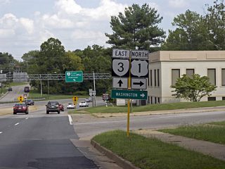
A cloverleaf interchange joins SR 3 (William Street) with U.S. 1 (Jefferson Davis Highway) in the city of Fredericksburg. SR 3 splits with SR 3 Business (William Street) for Blue and Gray Parkway around Downtown Fredericksburg just east of U.S. 1.
08/31/09

SR 3 (History Land Highway) continues south from SR 203 (Oldhams Road) at Lyells three miles to the town of Warsaw and 34 miles to Kilmarnock.
06/25/10

SR 3 (History Land Highway) expands to four lanes ahead of the split with SR 3 Business (Main Street) to bypass Warsaw.
06/25/10

SR 3 Business lines Main Street southwest 0.77 miles to U.S. 360 (Richmond Road) beyond Downtown Warsaw.
06/25/10

SR 670 (Scott Town Road) provides a cutoff to U.S. 360 (Richmond Road) west from SR 3 (History Land Highway) south in Warsaw.
06/25/10

SR 3 (History Land Highway) curves southwest into the signalized intersection with U.S. 360 (Richmond Highway).
06/25/10


SR 3 west and SR 198 east combine for 1.55 miles along Buckley Hall Road between Soles and Twiggs Ferry Road near Dixie.
06/25/10

SR 198 loops 7.17 miles southeast to meet SR 14 north of Mathews. SR 3 angles northwest and than northeast 15.41 miles to White Stone, where SR 200 branches west to Irvington.
06/25/10


SR 3 (Twiggs Ferry Road) continues northwest 1.37 miles from SR 198 to the Middlesex County line. Located 11 miles away, Deltaville lies near the east end of SR 33.
06/25/10

SR 3 (Twiggs Ferry Road) spans the Piankatank River north to Wilton Point in Middlesex County.
06/25/10

The Twiggs Bridge across the Piankatank River was originally built in 1957 and reconstructed in 2014.1
06/25/10

The bridge taking SR 3 over the Piankatank River measures 2,092 feet in length. It ascends 42.7 feet above the navigation channel.1
06/25/10

SR 655 is Ferry Road at the south end of Wilton Point. The Twiggs Ferry was originally a part of SR 225.
06/25/10

SR 630 (Stampers Bay Road) provides 1.00 mile long a cut off northeast to SR 33 (General Puller Highway) east to Wilton, Hardyville and Deltaville.
06/25/10

SR 653 comprises a local loop along the east side of SR 3 (Twiggs Ferry Road) through Stampers.
06/25/10

SR 33 (General Puller Highway) spurs 8.41 miles east to Deltaville and Stingray Point on Chesapeake Bay.
06/25/10


SR 3/33 (General Puller Highway) overlap 3.45 miles northwest to Grafton and Harmony Village.
06/25/10

SR 626 (Regent Road) heads 0.43 miles north to Free Shade Corner, where it splits with SR 624 north to Syringa an route to Wake.
06/25/10

SR 707 (Grafton Church Road) loops west from SR 3/33 along the original alignment of SR 33 through Grafton.
06/25/10

SR 3 branches northeast from SR 33 (General Puller Highway) along Greys Point Road to the Robert Opie Norris Bridge and White Stone.
06/25/10

SR 33 expands into a four lane highway ahead of the split with SR 3 west at Harmony Village.
06/25/10

SR 33 (General Puller Highway) continues 6.89 miles west to U.S. 17 Business (Gloucester Road) in the Middlesex County seat of Saluda.
06/25/10


SR 3 replaced SR 200 along Greys Point Road northeast from SR 33 to the former Grey Point - Whitestone Ferry across the Rappahannock River.
06/25/10

The Robert O. Norris, Jr. Bridge lies four miles northeast of SR 657 (Kates Neck Road) along SR 3.
06/25/10

SR 645 (Locust Grove Road) heads north and than east to residential areas along Meachim Creek.
06/25/10

SR 646 (Long Point Lane) connects SR 3 with SR 663 (Planview Road) north to Hummel Field Airport (W75).
06/25/10

SR 621 (Locklies Creek Road) branches east from SR 3 (Greys Point Road) to Locklies along the Rappahannock River.
06/25/10

The 9,989 foot long
06/25/10

The Rappahannock River empties into Chesapeake Bay beyond the distant Mosquito Point and Stingray Point east of the Robert O. Norris, Jr. bridge.
06/25/10

Tolls were previously collected for the Norris Bridge just beyond the north end of the span.
06/25/10

SR 3 (Rappahannock Drive) advances northeast into the town of White Stone where it meets the south end of SR 200 (Chesapeake Drive).
06/25/10

SR 695 spurs 7.69 miles southeast from SR 3/200 in White Stone Palmer and Westland on Fleets Island. SR 200 loops west to Irvington and north back to SR 3 at Kilmarnock.
06/25/10

SR 200 west to Irvington and Christ Church was formerly the route of SR 3. SR 3 north along Mary Ball Road to Kilmarnock Road was the original alignment of SR 200.
06/25/10

SR 3 expands to a four lane, divided highway between White Stone and the town of Kilmarnock.
06/25/10

The short loop along SR 702 (Methodist Church Road) north to SR 646 (Ocran Road) is the original alignment of SR 200.
06/25/10

SR 646 (Old Salem Road) meanders 3.16 miles northwest to SR 200 (Irvington Road) at Pitmans Corner and SR 222 (Weems Road) north of Christ Church.
06/25/10

SR 1036 (Harris Road) loops 1.82 miles northwest from SR 3 at SR 759 (Simmons Lane) to SR 200 (Irvington Road) at SR 688 (James B. Jones Memorial Highway).
06/25/10

SR 650 (Fleets Bay Road) spurs 3.01 miles east from SR 3 (Mary Ball Road) along Fleets Back Neck.
06/25/10


- TWIGG'S FERRY ROAD over PIANKATANK RIVER. http://bridgereports.com/1577449 BridgeReports.com.
- Robert O. Norris Bridge. https://bridgehunter.com/va/lancaster/12083/ BridgeReports.com.
Connect with:
Interstate 95
U.S. 1
U.S. 15
U.S. 17
U.S. 29
U.S. 360
U.S. 522
State Route 33
State Route 198
State Route 200
State Route 203
Page Updated 05-08-2021.