California 75
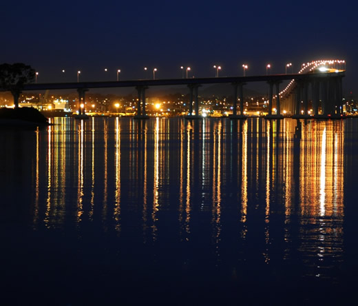
Looking east from Glorietta Bay Park in Coronado, the San Diego-Coronado Bay Bridge illuminates the night sky and reflects onto the calm waters of San Diego Bay. Photo taken 12/03/06.
California 75 begins at Interstate 5 in San Diego. It starts as east-west Palm Avenue through southern San Diego (Otay-Nestor) and Imperial Beach, then turns due north to parallel the coastline along the Silver Strand Boulevard. Upon reaching Coronado, California 75 follows Orange Avenue, the major north-south roadway through that beach community. It passes by the famous Hotel Del Coronado, viewed as one of the top tourist attractions in the San Diego area. Once passing through downtown Coronado, California 75 turns east to cross the San Diego Bay via the Coronado Bay Bridge. The highway comes to its end at Interstate 5 in the Barrio Logan community of San Diego.
Prior to 1976, what is now known as California 905 was an easterly extension of California 75. This section was renumbered as California 117 in 1976 and then renumbered again to California 905 in 1985 per legislative action. The route was likely split because no one would logically drive California 75 from Otay Mesa to Imperial Beach to Coronado to downtown San Diego. California 117 was renumbered as California 905 due to the planned conversion of that highway into a freeway with potential aspirations as the Interstate 905 corridor.
California 75 Highway Guides
- 1969. The Coronado Bay Bridge opens; this new span replaces the old Coronado Ferry and extends California 75 east to meet Interstate 5 (old U.S. 101) just southeast of downtown San Diego.
- 1975. California 75 is curtailed from its prior extension east to Otay Mesa. Now the highway begins at Interstate 5 in the South Bay, continues north along the Silver Strand to Coronado, then culminates at the Interstate 5 junction in Barrio Logan. The eastern extension of California 75 is renumbered to California 117 (which later becomes California 905); the freeway is under construction in 1975.
- July 2002. The toll is removed from the San Diego-Coronado Bay Bridge.
- 2005. Plans called for construction of a tunnel along California 75 and California 282 between the foot of the San Diego-Coronado Bridge and the entrance to the naval air station at North Island. Such a facility would be very expensive to construct.
The San Diego-Coronado Bay Bridge
One of the most striking features of the San Diego Skyline is the San Diego-Coronado Bay Bridge. With its sweeping blue arch flying high above the waters of the San Diego Bay, the bridge is known for its simple design and high arch. Many of the graphical presentations of San Diego's skyline feature the bridge in the artwork. In addition, this is the only bridge to cross San Diego Bay, so part of its beauty lies in its uniqueness. Built as a toll bridge, the tolls were removed in July 2002.
The bridge was completed in 1969 as a replacement to the ferry service that used to connect Coronado with downtown San Diego at the Broadway Pier. Although some ferry service remains, the bridge has largely supplanted the ferry for commuter traffic. Many travelers who take the bridge work for the military, as Coronado is home to the North Island Naval Air Station. In addition, tourists flock to the bridge to reach the beaches of Coronado and the famed Hotel Del Coronado located off Orange Avenue (California 75) toward the south end of town.
In an article by Thomas Lux in the March 16, 2000, San Diego Reader are some facts about the bridge. These facts were collected prior to the removal of the toll from the bridge in July 2002.
- Principal architect: Robert Mosher
- Opened on August 3, 1969
- in 1970, it won the Most Beautiful Bridge Award from American Institute of Steel Construction
- 2.12 miles (11,179 feet) long
- cost $50 million to build
- retrofitting will cost $70-150 million
- 20,000 tons of steel (13,000 tons in structural steel and 7,000 in reinforcing steel)
- 94,000 cubic yards of concrete
- 900,000 cubic yards of dredged fill
- some caissons for the towers were drilled and blasted 100 feet into the bed of the San Diego Bay
- 4.67% grade from Coronado to San Diego
- side railings are concrete blocks only 34 inches high
- over 50 people work 24 hours a day, seven days a week to maintain the bridge and take its tolls
- the grade and the 90-degree angle turn is to create clearance for an empty aircraft carrier to pass beneath it
- the bridge is the third largest orthogonal box in the country - the box is the center part of the bridge, between piers 18-21 over main shipping channel
- 2,850 of curved steel is contain the largest such segments in the country
| California 75 scenes |
|---|
| These views of downtown San Diego are taken from the Coronado Ferry Landing in the city of Coronado about two blocks east of the northern terminus of Orange Avenue. Photos taken 02/19/05. |
| Looking toward downtown San Diego's skyline from Centennial Park near the Coronado Ferry Landing, a light cloud cover provided dramatic lighting. Photos taken 01/18/09. | |||
| Looking northwest from the same vantage point, aircraft carriers stationed at North Island Naval Air Station along San Diego Bay are visible. Photo taken 01/18/09. | |
| Looking north from the San Diego Coronado Bay Bridge westbound lanes is this view of downtown San Diego. Harbor Drive (Old U.S. 101) is the four-lane roadway that can be seen traveling north past the San Diego Convention Center and Petco Park (Home of Major League Baseball's San Diego Padres). Photo taken 01/18/09. | |
| The San Diego-Coronado Bay Bridge, which connects the city of Coronado with San Diego, arcs over the San Diego Bay. Five lanes wide, the bridge has reversible lanes that are adjusted to accommodate rush hour traffic. Photo taken 07/06/99. | |
| From Coronado Ferry Landing, the San Diego-Coronado Bay Bridge arcs across the bay between Coronado and the shipyards of Barrio Logan. Photo taken 02/19/05. | |
| This view of the San Diego-Coronado Bay Bridge is taken from the Grand Hyatt hotel's 40th floor "Top of the Hyatt" bar. Photo taken 01/18/09. | |
| Looking west from Interstate 5 on the ramp onto California 75 south near the Cesar Chavez Parkway exit is this view looking west toward the San Diego-Coronado Bay Bridge and city of Coronado. Photo taken 02/19/05. | |
| Now looking west from Old U.S. 101 (Harbor Drive), this view shows the underside of the San Diego-Coronado Bay Bridge from Barrio Logan. Photo taken 02/19/05. | |
| View of the San Diego-Coronado Bay Bridge as seen from the ferry landing about two blocks east of the northern terminus of Orange Avenue. Photo taken 12/14/02. | |
| Signage for the toll crossing entrance from Cesar Chavez Parkway (The parkway was known as Crosby Street at the time this picture was taken; Crosby Street was a surface street near the Interstate 5/California 75 interchange near Barrio Logan that was renamed as Cesar Chavez Parkway in April 2002.) to San Diego-Coronado Bay Bridge. This crossing is no longer toll (as of July 2002), so this sign has been removed. Photo taken 07/06/99. | |
| This is an on-ramp from Logan Avenue (near Cesar Chavez Parkway) onto the San Diego-Coronado Bay Bridge. Photo taken 08/08/04. |
Page Updated June 23, 2009.


