California 125

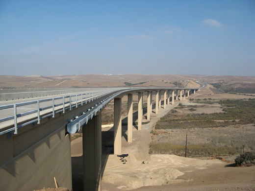
California 125 crosses the Otay River Valley on this massive precast segmental bridge opened to traffic on November 19, 2007. This view is afforded looking north toward Otay Ranch in Chula Vista. Photo taken 11/17/07.
California 125, part of the inner and outer loop system of freeways around San Diego, begins at California 905 in Otay Mesa and travels north to California 52 (Soledad Freeway) in Santee. While most of the route is completed, a proposed segment from California 52 to Scripps Poway Parkway remains unconstructed and planned for a future construction, perhaps by 2020.
California 125 Highway Guides
- California 125 North - 905 to 94
- California 125 North - 94 to 52
- California 125 South - 52 to 94
- California 125 South - 94 to 905
California 125 was constructed in four sections. The portion between California 94 and Interstate 8 is the oldest (and opened as part of California 67). The portions north to California 52 and south to California 54 were built next, and the last segment to open was the tolled section south to California 905. Here's a more detailed history, starting with the southernmost segment and working our way north:
South Bay Expressway
The southernmost California 125 segment is the South Bay Expressway (formerly known as the San Miguel Parkway), which runs from California 905 north to California 54. TransNet (a local, half-cent sales tax dedicated to transportation projects) funded a small portion of California 125 from California 54 south to San Miguel Road in Bonita, while the majority of the route is operated as a tollway. Initial construction of this TransNet-funded segment of California 125 was a four-lane freeway built at a cost of $264 million. Future construction will upgrade this segment of California 125 to eight lanes with two HOV (high occupancy vehicle) lanes for an additional $110 million. TheSan Diego Association of Governments (SANDAG) forecast that California 125 will carry between 60,000 to 70,000 vehicles per day around Otay Mesa and between 80,000 to 100,000 vehicles per day in the north Chula Vista area. Much of the traffic count is dependent upon the future housing developments planned in the area, including Otay Ranch and Eastlake.
The South Bay Expressway tolled segment of California 125 was authorized to be a potential tollway by state Assembly Bill 680 in July 1989, which allows for public-private ventures for tollway construction. Under this plan, a private, for-profit corporation (initially California Transportation Ventures and later South Bay Expressway Ltd., a subsidiary of The Macquarie Infrastructure Group of Australia) was to charge tolls on the designated toll segment of California 125 for 35 years after the toll road opened on November 19, 2007, or until 2042. With the recession that began in 2008, along with the housing collapse, traffic never reached projected levels, and the for-profit operator was unable to make bond payments, owing as much as $510 million in 2010. The operator reorganized from bankruptcy protection beginning in March 22, 2010. It emerged from bankruptcy in April 2011 as the new South Bay Expressway LLC. In July 2011, SANDAG expressed interest in taking over the toll road from South Bay Expressway LLC. On December 16, 2011, the purchase of the toll road from South Bay Expressway LLC to SANDAG for $351.7 million was approved by the SANDAG board, thus moving the operation from a for-profit operator to a governmental non-profit agency.1,2
Sweetwater Segment
Immediately north of the California 54 interchange is the Sweetwater segment of California 125, so named because it parallels Sweetwater Road through Spring Valley. This segment ends at the massive interchange with California 94. This section opened to traffic in May 2003.
Helix Freeway
Between California 94 and Fletcher Parkway (Amaya Drive), California 125 follows the Helix Freeway. The original configuration has seen some interchange modifications, including a revamping of the California 94/125 interchange. This section was originally part of a southern extension of California 67 and is the oldest segment on California 125; the portion between California 94 and Interstate 8 dates back to the 1950s (the Panorama Drive underpass and Mariposa Street overpass date to 1957). The interchange between Interstate 8 and California 125 was reconstructed between 1984 and 1993; the completed stack interchange opened on April 15, 1993. The Fletcher Parkway overpass and connection to Amaya Drive was fully opened on January 3, 2001.
Fanita Segment
Between Fletcher Parkway (Amaya Drive) and California 52 is the Fanita segment of California 125, again named for the road that it closely parallels. The section between Fletcher Parkway and Navajo Road opened in March 2001, and the section between Navajo Road and Grossmont College Drive opened in mid-2002. The northernmost section between Grossmont College Drive and Mission Gorge Road opened to traffic in phases between May and July 1998; construction began on April 3, 1996.
North of California 52 - Unconstructed
California 125 is currently proposed as an expressway from California 52 north to Scripps-Poway Parkway and possibly Poway Road. However, this routing is currently very controversial, leaving it very unlikely that California 125 will ever be extended north of California 52. As currently envisioned, this expressway would take pressure off Interstate 15 and arterials such as Pomerado Road. This would allow direct travel between El Cajon and Poway without using either Interstate 15 or California 67. This highway, which is part of the San Diego Outer Loop, was at one time projected to carry between 40,000 to 70,000 vehicles per day by 2020 according to SANDAG estimates. California 125 is planned as a six-lane expressway from California 52 to Scripps-Poway Parkway with a four-lane connection to Poway Road. This had a price tag of $132 million back in 1997; it has certainly increased since then. East-west Scripps-Poway Parkway itself is a relatively new road; it was extended east to California 67 in 1998. Most focus of creating a new north-south freeway or expressway corridor has shifted to California 67 now that the California 52 extension to Santee has opened.
In March 2003, San Diego County Supervisor Bill Horn presented his vision of a new north-south freeway corridor that would lead from the current planned northern terminus of California 125 in Poway north to Interstate 10 in Riverside County, roughly paralleling Interstates 15 and 215 past Escondido, Temecula, and Perris. Supervisor Horn did not refer to this corridor as California 125, even though that would be the logical designation for such a route. The map below depicts a rough proposal of what would be this freeway's route based on Supervisor Horn's vision. This freeway is not on official planning documents, is not a legislatively route, would be very controversial, and therefore is unlikely to ever be constructed. This freeway corridor would also allow for a bypass of California 67, which carries a great deal of traffic and is seen as dangerous due to lack of passing lanes, steep grades, and limited sight distances. Since much of the land is currently undeveloped along this proposed corridor, the biggest impacts would be environmental and economic. This proposal seemed to fade out and is not seriously being pursued.
| California 125 scenes | |
|---|---|
| In lieu of a typical freeway entrance shield, this "South Bay Expressway" trailblazer is featured at all access points to the toll road section of California 125. This particular sign is located at the Birch Road interchange with California 125 near the Otay Ranch shopping mall. Photo taken 11/17/07. | |
| The South Bay Expressway, between California 905 and East H Street, opened to bicyclists, pedestrians, and runners during a preview event held on November 17, 2007. A festival celebrated the opening of the new toll road at the Otay Ranch shopping mall. Photo taken 11/17/07. | |
| This series of photos shows the Sweetwater Reservoir near the present-day alignment of California 125, including a power substation that today is seen from the tollway but in 2004 was only visible from hiking trails around the reservoir. Photos taken 11/06/04. | |||
| Shields for California 94 and California 125 along eastbound Broadway in Spring Valley. Photo taken 06/99. | |
| Signage for California 94 and California 125 along eastbound Broadway in Spring Valley. Photo taken 07/14/02. | |
| This sign advising motorists of the California 125 project was posted along northbound Sweetwater Road as it approached Broadway under the then-future California 94/125 interchange. Much has changed since this picture was taken. Photo taken 07/14/02. | |
| This view of the then-future California 94/125 interchange was seen from eastbound Broadway in Spring Valley. Photo taken 07/14/02. |
| This series of pictures shows the Mariposa Street/Merritt Boulevard overpass at California 125 (Helix Freeway). Owing to its age as a freeway, Caltrans installed a C-block to denote the rights of way for the Helix Freeway. Photos taken 10/21/06. | ||||
| Looking north from the Mariposa Street/Merritt Boulevard overpass at California 125 (Helix Freeway), we see a busy north-south freeway heading north toward Lemon Avenue and Interstate 8. Photo taken 10/21/06. | |
| Eastbound Mission Gorge Road approaches the connection to California 125 south to Spring Valley and Chula Vista. Photo taken 03/28/09. | |
| California 125 Construction - Fletcher Hills Segment | |
|---|---|
| Construction for California 125 at the Amaya Road / Fletcher Parkway overcrossing. Photos taken 06/07/00. | ||
Sources:
- Toll road operator files for Chapter 11: South Bay Expressway use below forecasts, by Steve Schmidt, San Diego Union-Tribune, March 23, 2010
- SANDAG OKs purchase of South County toll road: Officials plan to lower fares in effort to attract motorists, by Robert J. Hawkins, San Diego Union-Tribune, December 16, 2011
Page Updated January 27, 2013.


