
Our latest roadtrip took us to Las Vegas and southwestern Utah last month. The goal was to mix in roads with hiking while also visiting White Pine County in eastern Nevada. Also conferring with the TravelMapping website, we aimed to drive every stretch of state route designated along the Las Vegas area urban arterials.
Also, Interstate 11 is now fully signed in both directions from Henderson to SR 157 (Kyle Canyon Road) in northwestern Las Vegas. We only noted one remaining interchange sequence sign along I-15 that references Interstate 515. The north end is not where the freeway along U.S. 95 ends, but is the end of the developed area of Las Vegas.
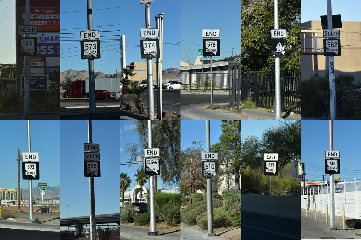
The bulk of the photos covering the Las Vegas area have already been added to the guide pages. The urban state routes are generally signed at their end points, and sparsely signed otherwise. There are some exceptions either way:
Nevada State Route 146 – follows St. Rose Parkway northeast from I-15 to I-215 at Pecos Road. Shields are only posted at the SPUI with I-15 and by the intersection with Las Vegas Boulevard.
Nevada State Route 147 – follows Lake Mead Boulevard east from Pecos Road and the North Las Vegas city line to the North Entrance to Lake Mead National Recreation Area. There are no shields posted along the route, but mileposts along the stretch east from the Sunrise Manor to the park boundary include SR 147 markers. The lone shield observed anywhere is a Junction SR 147 marker posted on SR 612 (Nellis Boulevard) southbound.
Nevada State Route 159 – what is left of Nevada State Route 159 along Charleston Boulevard in Las Vegas has one shield posted westbound after SR 612 (Nellis Boulevard). The bulk of Charleston Boulevard was turned over to local maintenance in 2022. This left a short section at Interstate 15, and from Fremont Street (SR 582) east to Nellis Boulevard as SR 159. SR 159 remains designated west from Clark County Route 215 to Red Rock Canyon National Conservation Area.
Nevada State Route 160 – follows Blue Diamond Road west from Las Vegas Boulevard and I-15 to the Spring Mountains. We only took the spur east from I-15 to Las Vegas Boulevard, verifying that the east end shields and first west shields are still posted.
Nevada State Route 562 – follows Sunset Road east from Las Vegas Boulevard along the boundary of Harry Reid International Airport (LAS) to the Henderson city line. The route is marked at both end points.
Nevada State Route 564 – follows Lake Mead Parkway from the Henderson Bowl interchange with I-11/215 in Henderson to Lake Mead National Recreation Area. Only the begin shield for westbound remains posted. The shields on eastbound posted after I-215 and after Boulder Highway (old SR 582) are gone.
Nevada State Route 573 – two sections of Craig Road are designated as SR 573. The western section joins I-11/U.S. 95 with Decatur Road at the North Las Vegas city line. There are begin and end shields on this stretch. Marked only at the east end, the eastern segment follows Craig Road from west of I-15 in North Las Vegas to SR 604 (Las Vegas Boulevard).
Nevada State Route 574 – Cheyenne Avenue between Decatur Boulevard and SR 612 (Nellis Boulevard) is SR 574. This is a lone end shield posted eastbound and just one reassurance marker posted west of Losee Road in North Las Vegas.
Nevada State Route 578 – a 0.66 mile long section of Washington Avenue is SR 578 between I-15/U.S. 93 and Las Vegas Boulevard. The lone shield is posted west of the state maintained portion of Washington Avenue. There are end shields posted in both direction, but the route is otherwise unsigned.
Nevada State Route 579 – paralleling SR 578 (Washington Avenue) to the south along Bonanza Road. SR 579 runs between SR 599 (Rancho Drive) and Las Vegas Boulevard in Downtown Las Vegas.
Nevada State Route 582 – the former route of U.S. 93/95 between Henderson and Las Vegas, SR 582 was truncated in 2022 from Fremont Street south to the intersection with SR 159 (Charleston Boulevard). The south end along Boulder Highway was formerly at I-11/U.S. 93-95 and the Wagonwheel Interchange in south Henderson. It is now at the seemingly random location where Boulder Highway meets Broadbent Boulevard. There is at least one shield still posted along Boulder Highway for SR 582, and additional signage on Nellis Boulevard.
Nevada State Route 589 – all of SR 589 along Sahara Avenue was dropped by 2018. A short unsigned section was readded by 2022, covering Sahara Avenue east from Rancho Drive at I-15 to Sammy Davis, Jr. Drive. Otherwise, remnant begin and end shields for SR 589 remain at SR 595 (Rainbow Boulevard).
Nevada State Route 592 – two sections of Flamingo Road remain designated as SR 592. The western leg joins SR 595 (Rainbow Boulevard) at Spring Valley with I-15 by the Las Vegas Strip. The eastern segment runs between Paradise Road and SR 582 (Boulder Highway). The only shields noted are at the west end.
Nevada State Route 593 – two sections of Tropicana Avenue are still designated as SR 593. The western portion joins Dean Martin Drive, to the immediate west of I-15, with Las Vegas Boulevard on the Las Vegas Strip. This section was recently resigned following completion of the Tropicana Interchange reconstruction project. The eastern section of SR 593 lines Tropicana Avenue from Maryland Parkway in Paradise to SR 582 (Boulder Highway). Signage for SR 593 was added at I-15 this year. Two shields are also posted along Tropicana Avenue west from Boulder Highway.
Nevada State Route 595 – follows Rainbow Boulevard north from Tropicana Avenue in Spring Valley to Washington Avenue adjacent to I-11/U.S. 95 in Las Vegas. There are begin and end shields at both end points, and at least one reassurance marker posted along the urban boulevard.
Nevada State Route 596 – there are two sections of Jones Boulevard designated at SR 596. With one shield posted southbound after I-11/U.S. 95, the southern section follows Jones Boulevard between Sahara Avenue to Aberdeen Lane / Clarice Avenue. The unsigned northern leg extends north from Smoke Ranch Road to SR 599 (Rancho Drive). There are still end/begin shields along Jones Boulevard at Smoke Ranch Road, from when SR 596 was designated from that point south instead of north.
Nevada State Route 599 – also designated as U.S. 95 Business, SR 599 follows Rancho Drive northwest between I-11/U.S. 95 in Las Vegas. The business route for U.S. 95 is only acknowledged on select guide signs along Interstate 11. The route is otherwise only marked sparingly as SR 599.
Nevada State Route 610 – Lamb Boulevard between SR 604 (Las Vegas Boulevard) and I-15/U.S. 93 in North Las Vegas is SR 610. There are begin/end shields at Las Vegas Boulevard and an end shield northbound ahead of the SPUI with Interstate 15.
Nevada State Route 612 – probably the best signed route of all the Las Vegas urban arterials, SR 612 follows Nellis Boulevard between SR 593 (Tropicana Avenue) and SR 604 (Las Vegas Boulevard). In addition to begin and end shields, confirming markers are posted for SR 612 at SR 147 (Lake Mead Boulevard), SR 159 (Charleston Boulevard) and SR 574 (Cheyenne Avenue).
Nevada State Route 613 – Summerlin Parkway was a locally maintained freeway joining CC-215 (Bruce Woodbury Beltway) with I-11/U.S. 95 at SR 595 (Rainbow Boulevard) until 2019, when NDOT assumed maintenance. Three confirming markers were added along each direction, but the route remains unmarked on guide signs along both CC-215 and Interstate 11.
