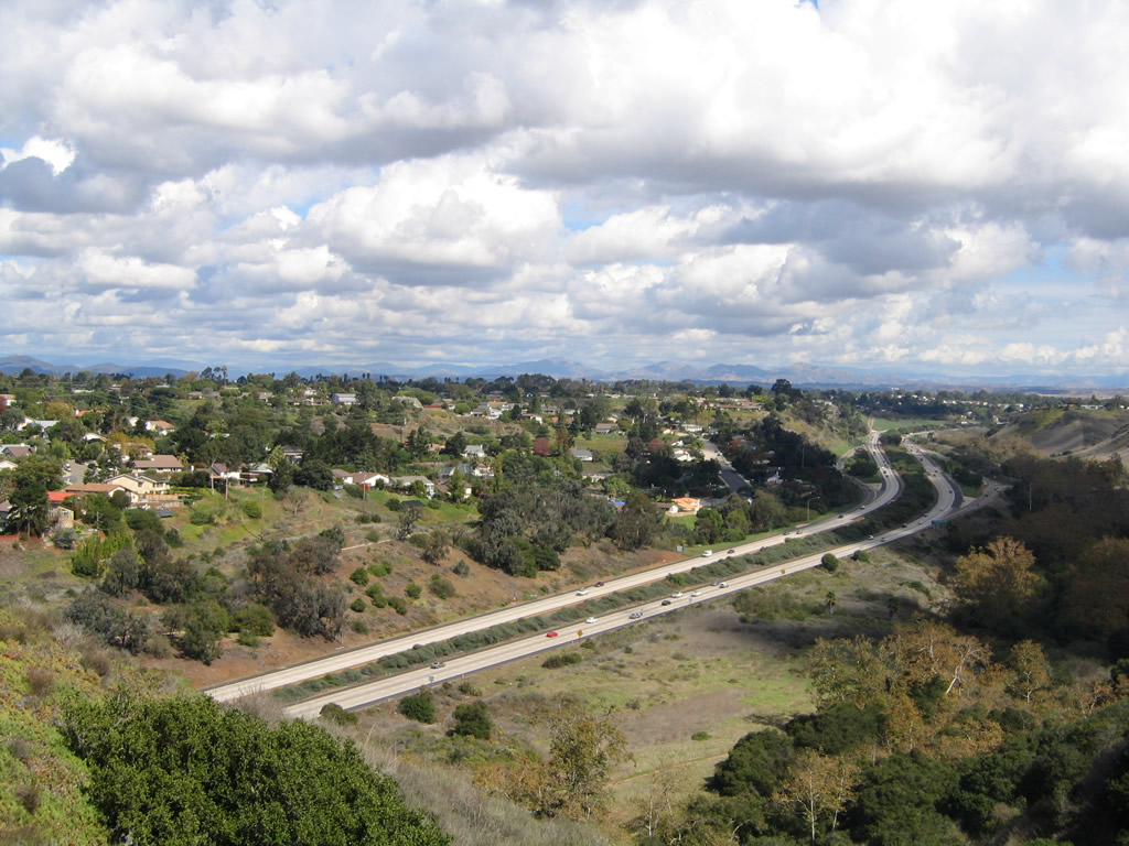
California 52 is the Soledad Freeway, starting at Interstate 5 at the foot of Mount Soledad in Rose Canyon, then heading east through San Clemente Canyon to Interstate 805. At Interstate 805, the freeway climbs out of San Clemente Canyon, headed to the top of the old Miramar Landfill. The freeway was constructed on top of the original landfill, and as such, the freeway undulates (dips) as the trash settles beneath it. At Convoy Street, motorists may reach the expanded Miramar Landfill for refuse disposal. California 52 continues east from here as an eight-lane facility, with two lanes exiting for California 163, Kearny Villa Road (Former U.S. 395), and Interstate 15. The mainline continues east, narrowing to four lanes as it passes through the Mission Trails Regional Park. There are climbing lanes through the western part of the park, but the point at which the three lanes merge into two lanes is a choke point for rush hour traffic. The freeway leaves the city of San Diego immediately after leaving the park. Currently, California 52 ends at its transition into southbound California 125, but the freeway is planned to be extended to California 67 through Santee. Land acquisition began in August 2002, and construction began in 2007. The first segment to open will connect California 125 with Cuyamaca Street. Assuming no complications, the extension of California 52 east to California 67 in Santee will be complete by late 2010.
History
California 52 has been built in stages, initially between Interstate 5 and Interstate 805 and gradually extending east, with the final planned segment to open between California 125 and California 67 in Spring 2011.
Key Opening Dates of California 52 freeway sections:
La Jolla Parkway (former Ardath Road) to Interstate 5 – May 28, 1970
Interstate 5 Separation to Ayar Overhead – December 23, 1966
Ayar Overhead to Genesee Road Undercrossing – May 28, 1970
Genesee Road Undercrossing to Interstate 805 Separation – March 22, 1972
Interstate 805 Separation to San Clemente Creek – July 28, 1987
San Clemente Creek to Convoy Street – July 28, 1987 (widened August 5th, 1994)
Convoy Street to California 163 – June 30, 1988 (widened August 5th, 1994)
California 163 to Interstate 15 – June 30, 1988
Interstate 15 - April 4, 1988
Interstate 15 to Santo Road – April 4, 1988 (widened December 17, 1993 and again in 2009)
Santo Road to San Diego River – December 17, 1993
San Diego River to California 125 – May 15, 1998
California 125 to California 67 - Spring 2011
Many thanks to C.J. Moon for his assistance in providing this historical chronology.
Highway Guide
Torrey Pines Road north
The first appearance of Interstate 5 and California 52 overhead sign trailblazers along northbound Torrey Pines Road (Historic U.S. 101W) occurs at the intersection with La Jolla Shores Drive and Torrey Pines Lane. Photo taken 01/24/07.
An erroneous Interstate 52 shield is posted on the next set of overhead signs as Torrey Pines Road approaches La Jolla Parkway. Continue straight ahead to merge onto La Jolla Parkway east to California 52 and Interstate 5 south. Turn left on Torrey Pines Road north to Interstate 5 north and to continue along the route of Old U.S. 101. Photo taken 01/24/07.
La Jolla Parkway east
After departing the Torrey Pines Road intersection, eastbound La Jolla Parkway carries four lanes (two in each direction). La Jolla Parkway culminates in an interchange with Interstate 5 south and California 52 east. Use California 52 east to Interstate 805 north/south. Photo taken 08/21/04.
To California 52 east, use the left lane. To Interstate 5 south, use the right lane. Photo taken 08/21/04.
Eastbound La Jolla Parkway (former Ardath Road) transitions onto eastbound California 52 at this sign bridge, with an option to take Interstate 5/San Diego Freeway southbound. There is no access to northbound Interstate 5. This is the only remaining sign that uses the control city of "San Clemente Canyon" in association with east California 52. Photo taken 08/21/04.
California 52/Soledad Freeway east
Eastbound California 52 begins as La Jolla Parkway connects directly onto the freeway alignment. The single lane of eastbound through traffic from La Jolla Parkway receives additional lanes from northbound Interstate 5 (from the right) and southbound Interstate 5 (from the left). Photo taken 07/27/02.
The first exit along eastbound California 52 is Exit 1, Clairemont Mesa Boulevard east and Regents Road north. The first photo shows the connection to California 52 east from La Jolla Parkway, and the second photo shows the connection from Interstate 5 north. Photo taken 08/23/04.
The right lane becomes exit only for Clairemont Mesa Boulevard east and Regents Road north. Photo taken 08/23/04.
Eastbound California 52 reaches Exit 1, Clairemont Mesa Boulevard and Regents Road. Clairemont Mesa Boulevard heads south and then west from here, roughly parallel to California 52 through the Clairemont and Kearny Mesa communities of San Diego. Regents Road heads north into University City. Photo taken 08/23/04.
The next exit along eastbound California 52 is Exit 2, Genesee Avenue (some maps show this as a southerly extension of San Diego County Route S-21, but it is not signed as such), one mile. This sign was replaced in October 2003. Photo taken 08/23/04.
A California 52 east reassurance shield is posted after the onramp from Clairemont Mesa Drive and Regents Road. Photo taken 08/23/04.
Genesee Avenue travels north into the University City community of San Diego and south into the Clairemont community of San Diego. It is generally four lanes wide through San Clemente Canyon. Photo taken 08/23/04.
Eastbound California 52 reaches Exit 2, Genesee Avenue. Photo taken 08/23/04.
The next exit along eastbound California 52 is Exit 3, Interstate 805, 0.75 mile. From Interstate 5 east to the location of this picture, California 52 has followed narrow San Clemente Canyon. However, the canyon widens out at the Interstate 805 interchange, and California 52 leaves the canyon on the east side of the interchange. Photo taken 08/23/04.
This section of Interstate 805 is wholly within the city of San Diego. Interstate 805 travels north, straddling University City and Mira Mesa before ending at Interstate 5 in Sorrento Valley near Torrey Hills and Carmel Valley. To the south, Interstate 805 serves the communities of Clairemont and Kearny Mesa. Photo taken 05/22/04.
Eastbound California 52 reaches Exit 3, Junction Interstate 805 northbound and southbound. Photo taken 05/22/04.
Now looking at the transition ramp from eastbound California 52 to Interstate 805, use the left lane to connect to northbound and the right lane to southbound. Photos taken 08/23/04 and 05/22/04.
Back on the mainline, this view shows California 52 east as it passes through the Interstate 805 stack interchange as seen from eastbound California 52. Travelers on Interstate 805 would hardly realize that this interchange is so tall, since all of the connecting ramps are located under that freeway. Photos taken 08/23/04.
The next exit along eastbound California 52 is Exit 5, Convoy Street. Convoy Street leads south into Kearny Mesa, and it is well known for the many ethnically diverse eateries along its corridor. Photo taken 08/23/04.
As California 52 climbs out of San Clemente Canyon, it approaches this mileage sign for the next three exits: Exit 5, Convoy Street; Exit 6, Junction California 163 south; and Exit 7, Junction Interstate 15/Kearny Villa Road. Photo taken 08/23/04.
Eastbound California 52 reaches Exit 5, Convoy Street. This exit leads to the City of San Diego landfill. California 52 through this area was built on the original landfill, and as a result, the road has a tendency to sink. This forms the dips that are common along the road and is why the road is asphalt rather than concrete. Photo taken 08/23/04.
The next exit along eastbound is Exit 6, Junction California 163/Cabrillo Freeway south to downtown San Diego. There is no ramp to northbound California 163; northbound traffic should instead use north Interstate 15 (Exit 7). Photo taken 02/16/05.
This mileage sign along eastbound California 52 provides the distance to the next three exits: Exit 6, Junction California 163; Exit 7, Junction Interstate 15 and Kearny Villa Road; and Exit 8, Santo Road. Photos taken 05/16/09 and 08/23/04.
Eastbound California 52 reaches Exit 6, Junction California 163 Southbound and approaches Exit 7, Kearny Villa Road (old U.S. 395) and Junction Interstate 15. The ramps visible in the distance are associated with California 163, but this offramp leads to all three routes. Photos taken 05/16/09 and 08/23/04.
Use Exit 7 to Kearny Villa Road (former U.S. 395). Photo taken 05/16/09.
Immediately thereafter, eastbound California 52 next reaches Exit 7 for Kearny Villa Road and Interstate 15. Kearny Villa Road is the original U.S. 395, and an old expressway segment that parallels Interstate 15 between California 163 and Miramar Road is accessible by taking Kearny Villa Road northbound. Interstate 15 is a major north-south freeway that leads north to the northern reaches of San Diego as well as Escondido and eventually Temecula in Riverside County. Photos taken 05/16/09, 08/23/04, and 02/16/05.
Use Exit 7 to reach Kearny Villa Road (Old U.S. 395), which follows an old alignment of Interstate 15 to the north and follows the route of U.S. 395 from before the construction of California 163/Cabrillo Freeway. Photo taken 02/16/05.
Now on the transition ramp to Interstate 15 from eastbound California 52, the first ramp serves Kearny Villa Road (Old U.S. 395). The ramp to Interstate 15 south and north is just ahead. Note the newer sign at the gore point and the older sign on side of the road. Photos taken 02/16/05 and 05/16/09.
The right lane connects to Interstate 15 south. This new sign replaces the one seen on the left side in the previous photo. Photo taken 05/16/09.
Both lanes will connect to northbound Interstate 15, but only the right lane connects to the ramp to southbound Interstate 15 to Murphy Canyon and City Heights. Photo taken 05/16/09.
Traffic bound for south Interstate 15 departs here, while those connecting to northbound Interstate 15 will use the "Citizens for 52 Bridge" to make the connection. Cowles Mountain, the highest point within the city of San Diego and a focal point of Mission Trails Regional Park, comes into view in the distance. Photos taken 05/16/09 and 02/16/05.
The flyover transition ramp that carries traffic from California 52 east to Interstate 15 north is signed as the "Citizens for 52 Bridge." Photo taken 05/16/09.
This view looks north from the transition ramp toward Interstate 15 north. This view has changed as the new managed lanes project progresses. Photo taken 08/23/04.
Back on the mainline, this view shows the transition ramp that carries traffic from east California 52 to north Interstate 15 as seen from the mainlanes along eastbound. This transition ramp is signed as "Citizens for 52 Bridge." Photo taken 05/22/04.
The next exit along eastbound California 52 is Exit 8, Santo Road, 0.75 mile. Photo taken 02/16/05.
This mileage sign is found along eastbound California 52, and it provides the distance to Exit 8, Santo Road, and Exit 13, Mast Boulevard. An extra space was left on the sign for Jackson Drive, which was to be extended north through what is now Mission Trails Regional Park on the east side of Tierrasanta. The extension of Jackson Drive was removed from the regional transportation plan once the park was expanded westward. Photo taken 02/16/05.
Eastbound California 52 reaches Exit 8, Santo Road. Santo Road leads south into the Tierrasanta community. Most of this area burned in the wildfires of Sunday, October 26, 2003. Photo taken 05/22/04.
This mileage sign provides the distance to the next two exits along eastbound: Exit 13, Mast Boulevard and Exit 14, Mission Gorge Road. Omitted is unconstructed Jackson Drive interchange (but space for this exit was left on the highway sign even though Jackson Drive will not be built) and California 125 interchange. Photo taken 05/22/04.
Mission Trails Regional Park, with Fortuna Mountain and Cowles Mountain, comes into view after the Santo Road overpass. There are no exits for the next five miles. The park is owned and operated by the City of San Diego. To the north is the Marine Corps Air Station (MCAS) at Miramar, which is owned by the federal government. Photo taken 01/27/06.
This reassurance marker for California 52 is located immediately after the Santo Road interchange. Photo taken 05/22/04.
Eastbound California 52 passes through the scenic open space of Mission Trails Regional Park. Somewhere in the vicinity of this picture, Jackson Drive was at one time planned to connect to California 52. The road and the adjacent planned neighborhoods were never constructed, and those lands are now part of the Mission Trails Regional Park open space. Photo taken 05/22/04.
A climbing lane allows for a third lane as California 52 climbs toward Mission Trails Summit (the elevation of California 52 at this summit is 821 feet above sea level - the 1,291 feet cited on the sign is incorrect, has been corrected, and reflects the elevation at the top of nearby North Fortuna Mountain). Signage for the summit was placed in late 2005; the last photo (taken in 2009) shows the corrected elevation. A barrier-separated bike lane is also found on the shoulder of California 52. Photos taken 01/27/06 and 03/28/09.
After the top of the rise, California 52 reverts back to two lanes. During commute hours, this merge can cause traffic delays. Photos taken 05/22/04 and 01/27/06.
As California 52 descends from the summit, it approaches its next exit: Exit 13, Mast Boulevard, one mile. Photo taken 02/16/05.
A set of San Diego Gas and Electric electric transmission power lines crosses over California 52 in Mission Trails Regional Park. Photos taken 03/28/09.
Eastbound California 52 approaches Exit 13, Mast Boulevard, one-half mile. Photo taken 02/16/05.
Use Mast Boulevard north to West Hills Parkway south to reach San Diego's Mission Trails Regional Park. Santee Lakes are located north of Mast Boulevard via Fanita Parkway. Photo taken 02/16/05.
Eastbound California 52 reaches Exit 13, Mast Boulevard. Mast Boulevard heads south to Mission Gorge Road and northeast into Santee. Unfortunately, a short segment of Mission Gorge Road is not constructed near the boundary between Santee and Lakeside, thus rendering the street ineffective for regional traffic flow. Instead, traffic must use California 52 and Mission Gorge Road east. Photo taken 02/16/05.
This mileage sign along eastbound California 52 provides the distance only for Exit 14, Mission Gorge Road. Omitted for now are Exit 15, California 125 south and Exit 17, Cuyamaca Street. Photo taken 02/16/05.
After the Mast Boulevard interchange, California 52 crosses the San Diego River. Photo taken 05/22/04.
The next exit along eastbound California 52 is Exit 14, Mission Gorge Road. Mission Gorge Road provides an east-west connection through the heart of Santee and the best route to California 67. Exit 15 is Junction California 125 freeway south. Photo taken 03/28/09.
For the first time in its journey, California 52 departs the city of San Diego and enters the city of Santee. The sign was replaced between 2006 and 2009. Photos taken 03/28/09 and 01/27/06.
California 52 temporarily ends here at Exit 14, Mission Gorge Road. Through traffic is obliged to take California 125 south (Exit 15) all the way to Grossmont College Drive. Future plans call for California 52 to be extended to Cuyamaca Street (Exit 17) and eventually all the way to California 67. In addition, California 125 is to be extended north, but the exact path for California 125 has not yet been determined. Photo taken 02/16/05.
Upon exiting, the offramp widens to three lanes. Turn left to follow Mission Gorge Road east to Santee and right to Mission Gorge Road west to Mission Trails Regional Park and San Diego. Photo taken 03/28/09.
California 52 transitions directly onto southbound California 125 here (Exit 15) for now. Expect to see change happening here soon, as California 52 is extended east to Cuyamaca Street and then to California 67 (expected opening of extended freeway is March 2011). Photo taken 02/16/05.
California 52/Soledad Freeway west
California 52 begins in the city of Santee. Incorporated on December 1, 1980, Santee consists of 16.56 square miles, sits at an elevation of 350 feet above sea level, and had a population of 52,975 as of the 2000 Census. Continuing construction of new homes has brought rapid growth to this city, which lies northeast of the city of San Diego. A portion of Mission Trails Regional Park lies within the city limits of Santee, while the majority of the park is within the city of San Diego. This view of the nascent California 52 freeway is seen from the top of the transition ramp from northbound California 125 to westbound California 52. Note the stub ramps for the future easterly extension of California 52. Photo taken 02/16/05.
The first exit along westbound California 52 is Exit 13, Mast Boulevard. Photo taken 03/30/07.
Use Mast Boulevard east to West Hills Parkway south to Mission Gorge Road west to Mission Trails Regional Park. Hiking, bicycling, camping, and a museum are among the many offerings at the sprawling open space park. In addition, Mast Bouelvard east connects to Santee Lakes, which offer additional recreational opportunities. Photo taken 03/30/07.
Leaving Santee, California 52 enters the city of San Diego. Home to 1,223,400 people as of the 2000 Census, San Diego was the sixth largest city at that time, but it has since slipped to eighth largest (moving behind Phoenix and San Antonio). Annual precipitation at San Diego International Airport (Lindbergh Field) amounts to 10.77 inches annually, which makes San Diego an arid place. However, the agreeable climate allows for plant growth with sufficient irrigation. Being at the southern end of the state, water is a major concern here, as the vast majority of water is imported from the Colorado River or from Northern California via the State Water Project (California Aqueduct). Growth is expected to continue, despite the fact that San Diego has one of the highest costs of living in the country. Photo taken 03/30/07.
A half-mile advance sign for Exit 13, Mast Boulevard is posted shortly therefater. Photo taken 03/30/07.
California 52 crosses the San Diego River between the Mission Gorge Road and Mast Boulevard exits. This bridge more or less marks the city limits between Santee and San Diego, although technically the city of San Diego owns the San Diego River channel between this bridge and the California 52/125 interchange. Photos taken 03/30/07.
After the bridge, westbound California 52 reaches Exit 13, Mast Boulevard, the first San Diego exit along westbound. Photo taken 03/30/07.
Westbound California 52 enters Mission Trails Regional Park after the Mast Boulevard interchange. The next exit is in four and a half miles at Exit 8, Santo Road. Photo taken 03/30/07.
A California 52 west reassurance shield is posted after the onramp from Mast Boulevard. Photo taken 03/30/07.
California 52 west ascends to Mission Trails Summit (elevation 821 feet above sea level) in Mission Trails Regional Park. This grade is located between the Mast Boulevard and Santo Road interchanges. While there are three lanes along westbound at this point, the climbing lane used to end at the top of the grade but has been extended to Santo Road. This results in traffic delays for morning commuters who use California 52 to reach Interstate 15. Watch for bicycles, as they are permitted for use on this section of California 52. Photos taken 03/30/07.
After crossing the summit, the populated areas of the city of San Diego spread out from Mission Trails Summit on westbound California 52. This an incredibly beautiful view most mornings. Photos taken 03/30/07.
The next exit along westbound California 52 is Exit 8, Santo Road south to Tierrasanta. Photo taken 03/30/07.
Santo Road is a north-south arterial that passes through Tierrasanta Norte and Tierrasanta. Photo taken 03/30/07.
Prior to the Santo Road interchange, a variable message sign provides travel times to Interstate 805 and Interstate 5. Photo taken 03/30/07.
Westbound California 52 reaches Exit 8, Santo Road. Photo taken 03/30/07.
The next three exits along westbound are Exit 7, Junction Interstate 15 and Kearny Villa Road; Exit 6, Junction California 163; and Exit 5, Convoy Street. Photo taken 03/30/07.
The right two lanes connect to Interstate 15. Use Interstate 15 north to Scripps Ranch, Mira Mesa, Sabre Springs, and Rancho Bernardo. To the south, Interstate 15 passes through Murphy Canyon en route to Mission Valley and City Heights. California 163 is another freeway that travels southwest toward downtown San Diego. Photo taken 03/30/07.
A reassurance shield for California 52 west is posted after the onramp from Santo Road. The "elephant tracks" pavement marking indicates that the right lane becomes exit only. Photo taken 03/30/07.
Another mileage sign for California 52 west provides the distance to Exit 7, Junction Interstate 15/Escondido Freeway and Kearny Villa Road and Exit 6, Junction California 163/Cabrillo Freeway. Photo taken 03/30/07.
Westbound California 52/Soledad Freeway reaches Exit 7, Junction Interstate 15/Escondido Freeway and Kearny Villa Road. Use this exit for all destinations north of here; there is no access to California 163 north. Even though this exit guide sign was placed in 2006, there is no exit number posted on the overhead sign for Interstate 15. There is an exit number on the guide sign for Exit 6, Junction California 163/Cabrillo Freeway south to downtown. Photo taken 03/30/07.
Now on the collector-distributor lanes, the first ramp connects to northbound Interstate 15/Escondido Freeway to Escondido, Riverside, and San Bernardino. The next ramp on the c-d lanes connects to Interstate 15 south and then Kearny Villa Road. Photo taken 03/30/07.
Back on the main lanes, westbound California 52/Soledad Freeway approaches the offramp to Exit 6, Junction California 163/Cabrillo Freeway south to downtown San Diego. Photos taken 03/25/10 and 02/16/05.
Again returning to the collector-distributor lanes for Exit 7, the second ramp in this interchange connects to Interstate 15 southbound. The next ramp serves Kearny Villa Road (old U.S. 395). Photo taken 04/09/06.
The collector-distributor lanes split, with the right lane transitioning onto southbound Interstate 15 and the left lane continuing onto westbound California 52. Photo taken 04/09/06.
Meanwhile, on the main lanes, westbound California 52 (Soledad Freeway) reaches Exit 6, Junction California 163/Cabrillo Freeway south to downtown San Diego. The next exit on the mainline is Exit 5, Convoy Street. Photos taken 03/25/10 and 02/16/05.
Back on the collector-distributor lanes, the right lane departs onto Kearny Villa Road, while the left lane continues toward westbound California 52. Photo taken 04/09/06.
Blooming flowers are a common sight along this section of California 52 in March and April, and this year was no exception. The occasional orange poppy (state flower) blends well with the other colorful wildflowers. Photos taken 04/09/06.
After traffic joins the collector-distributor lanes from northbound California 163, the auxiliary lanes prepare to merge back onto the main lanes. Photos taken 03/25/10 and 04/09/06.
Decorative artwork graces the retaining wall that separates westbound California 52 from the transition ramp that connects southbound California 163 with westbound California 52. Photo taken 04/09/06.
Additional lanes join westbound California 52 after the California 163 interchange, and the freeway briefly has four westbound lanes. The right lane becomes exit only for the next offramp: Exit 5, Convoy Street. Photo taken 03/25/10.
This upcoming exits mileage sign along California 52 west provides the distance to the next three exits: Exit 5, Convoy Street; Exit 3, Junction Interstate 805 (Jacob Dekema Freeway), and Exit 2, Genesee Avenue. Watch this stretch of California 52 for dips in the freeway, because this particular section of freeway was constructed on top of an old landfill that was topped off in the middle of the 20th century. Note the pavement change from concrete in the previous photobox to asphalt here. This portion of California 52 is regularly repaved due to the constantly changing and undulating surface. Photo taken 03/25/10.
Westbound California 52/Soledad Freeway reaches Exit 5, Convoy Street. To the north of the freeway, California 52 skirts the southern edge of the Miramar Marine Corps Air Station and the city of San Diego's landfill. For waste disposal, use Exit 5 and follow Convoy Street north to the entrance to the landfill. To the south, Convoy Street passes through several business parks before emerging along one of the most diverse restaurant corridors in San Diego. A wide variety of ethnic restaurants, especially Asian restaurants, line Convoy Street south of Clairemont Mesa Boulevard. Photo taken 03/25/10.
The next exit along westbound California 52/Soledad Freeway is Exit 3, Junction Interstate 805 (Dekema Freeway). This major interchange connects California 52 with a major north-south corridor that provides a more direct connection to Interstate 5 north toward Los Angeles. Photo taken 03/25/10.
This upcoming exits mileage sign along California 52 west provides the distance to the next three exits: Exit 3, Junction Interstate 805 (Jacob Dekema Freeway), Exit 2, Genesee Avenue; and Exit 1B, Clairemont Mesa Boulevard and Regents Road. Photo taken 03/25/10.
The right lane of California 52 (Soledad Freeway) becomes exit only for Interstate 805. Use the two left lanes to continue west on California 52. Photo taken 04/09/06.
California 52 descends from Kearny Mesa into San Clemente Canyon. The freeway will follow this canyon west to Interstate 5, where San Clemente Canyon merges with Rose Canyon. Photo taken 04/09/06.
Use the two left lanes to continue west along California 52; use the right two lanes to exit onto Interstate 805. The characteristics of California 52 change after Interstate 805, as it has only four lanes total (two in each direction) and features a landscaped median. Photo taken 03/25/10.
A set of San Diego Gas & Electric 230kV power lines cross over the California 52 freeway near the Interstate 805 interchange. Photos taken 03/25/10.
The interchange between Interstate 805 and California 52 is a stack. California 52 forms the lowest level, while Interstate 805 forms the top deck. Photos taken 03/25/10.
More spring flowers adorn the right of way of California 52 as the freeway continues west through San Clemente Canyon. To the north lies the University City community of San Diego, while the Clairemont community is to the south of the freeway. Photo taken 04/09/06.
This upcoming exits mileage sign along California 52 east provides the distance to the next three exits: Exit 2, Genesee Avenue; Exit 1B, Regents Road and Clairemont Mesa Boulevard; and Exit 1A, Junction Interstate 5/San Diego Freeway and La Jolla Parkway west. Photo taken 03/25/10.
This reassurance shield for California 52 west is posted after the Interstate 805 interchange and prior to the Genesee Avenue interchange. Photo taken 03/25/10.
Use Genesee Avenue north to University City and south to Clairemont Mesa. Both of these are communities of the city of San Diego. Photo taken 03/25/10.
Westbound California 52/Soledad Freeway reaches Exit 2, Genesee Avenue. The original sign was replaced with an exit number sign in 2005. Photos taken 05/22/04 and 03/25/10.
Upon exiting, the first ramp connects to Genesee Avenue north, or stay left on the offramp to loop onto Genesee Avenue south to Clairemont Mesa. Genesee Avenue may be also designated as San Diego County Route S-21, although we've not seen any route markers with that designation southeast of Interstate 5. Photo taken 03/25/10.
The interchange with Genesee Avenue is a bit more complicated than a typical diamond interchange due to the contours of the landscape and the narrowness of the canyon. Photo taken 04/09/06.
The next exit along westbound California 52 is Exit 1B, Clairemont Mesa Boulevard and Regents Road. Clairemont Mesa Boulevard turns southeast toward the community of Clairemont, while Regents Road enters South University City. Regents Road ends just north of Governor Drive. There are proposals to construct a bridge over Rose Canyon, but the project has become extremely controversial. As of April 2006, it is not clear if the bridge will ever be built. Photo taken 03/25/10.
A California 52 west reassurance shield is posted after the onramp from Genesee Avenue. Photo taken 03/25/10.
Westbound California 52 reaches Exit 1B, Clairemont Mesa Boulevard southeast and Regents Road north. Photo taken 03/25/10.
This is the last reassurance shield for California 52 along westbound. Photo taken 03/25/10.
The final exit along westbound is Exit 1A, Junction Interstate 5/San Diego Freeway; the right two lanes will exit onto the freeway. Photo taken 03/25/10.
To continue west into La Jolla, use the left two lanes to follow La Jolla Parkway. Photo taken 05/22/04.
The Interstate 5 and California 52 junction is known as the Rose Canyon Interchange due to its location within Rose Canyon. California 52 passes over the Rose Canyon Fault here. Both right lanes exit onto Interstate 5 north/south. Photo taken 03/25/10.
Westbound California 52 reaches Exit 1A, Junction Interstate 5 north to Carmel Valley and south to Downtown. Photos taken 05/22/04 and 03/25/10.
Now on the transition ramp to Interstate 5, the left two lanes transition onto southbound Interstate 5, while the right lane has an exit to northbound Interstate 5. This marks the end of the northern Inner Belt created by the combination of California 125 and California 52. Photos taken 03/25/10.
Meanwhile, back on the mainline, California 52 serves as the top deck in the Rose Canyon Interchange; Interstate 5 is the bottom deck. Photo taken 05/22/04.
An increasing rarity, the end of California 52 is signed with an END shield. La Jolla Parkway, a city street that was formerly known as Ardath Road, continues from here into the community of La Jolla. Photo taken 01/18/09 and 01/24/07.
La Jolla Parkway west
After the END shield, the highway continues as a city-maintained street: La Jolla Parkway. There is one partial interchange on this route, which is shown here for La Jolla Scenic Drive North. There is no access to La Jolla Scenic Drive South because the bridge across the highway was never built due to resident opposition. Photo taken 02/16/05.
Westbound La Jolla Parkway reaches the offramp to La Jolla Scenic Drive North. To downtown La Jolla, continue straight ahead on La Jolla Parkway. Photo taken 02/16/05.
La Jolla Parkway is narrow and has a jersey barrier that acts as a separation between the two directions of traffic. Photo taken 01/24/07.
At the bottom of the hill, all traffic should prepare to stop for the upcoming traffic signals with Torrey Pines Road. To downtown La Jolla, continue straight. La Jolla Parkway will become Torrey Pines Road (historic U.S. 101W) south. Photo taken 01/24/07.
Turn right at the first trafic signal to Torrey Pines Road north to the University of California at San Diego. Photo taken 01/24/07.
The limited access La Jolla Parkway comes to an end at this traffic signal, where it meets Hidden Valley Drive and Torrey Pines Road. Follow Torrey Pines Road south to downtown La Jolla. Photo taken 01/24/07.
Westbound La Jolla Parkway meets Hidden Valley Drive and Torrey Pines Road at this intersection. Photo taken 01/24/07.
Torrey Pines Road south
Now on southbound Torrey Pines Road, a colorful median and pedestrian bridge dominate the view. The next traffic signal is with La Jolla Shores Drive. Photo taken 01/24/07.
Scenes Pertaining to California 52
Traveling north along Clairemont Mesa Boulevard prior to changing into Regents Road in San Clemente Canyon, these California 52 overhead signs provide motorists guidance to both directions of the California 52 freeway. Note the close-up photo of the second sign, which shows a scraped off "Ardath Road." Ardath Road is the former name of what is now known as La Jolla Parkway west of Interstate 5. Photos taken 10/28/04.
This view looks down on California 52 in San Clemente Canyon (Marian Bear Natural Park) toward the Clairemont Mesa Boulevard and Regents Road interchange (Exit 1) looking north and east. Photos taken 10/28/04.
Traveling west along Mission Gorge Road, this onramp offers a connection to California 52 west near the temporary eastern terminus of California 52 in Santee near the California 125 interchange. Photo taken 03/31/07.
A companion sign is found on eastbound Mission Gorge Road approaching the junction with California 52 and California 125 in Santee. Construction activities related with California 52's eastern extension to California 67 was evident at the time this photo was taken. Photo taken 03/28/09.
Mission Trails Regional Park is a large, open space park located in San Diego and Santee south of California 52. The best route through the park is via Mission Gorge Road. This photo shows Kumeyaay Lake near the campground off Mission Gorge Road and Father Junipero Serra Trail within the park. Photos taken 03/28/09.
The Old Mission Dam used to impound the San Diego River for the purpose of providing drinking and irrigation water for the San Diego Mission. The dam was finished between 1813 and 1816 but later fell into disrepair. A flume carried the water from this location downstream to the mission near Qualcomm Stadium. Photos taken 03/28/09.
A series of trailblazer shields for California 52 are posted along northbound Santo Road. A direct connection ramp leads from Santo Road to the California 52 bicycle lane. Photos taken 03/25/10.
West of Interstate 5, the approach road into California 52 is La Jolla Parkway (formerly Ardath Road). This four-lane expressway connects downtown La Jolla with California 52. This picture shows the signage approaching the onramp from La Jolla Scenic Drive South onto eastbound La Jolla Parkway (formerly Ardath Road). Note the use of the California 52 and Interstate 5 shields. This is a city of San Diego sign, hence why it is not up to Caltrans standards. Also note the substandard design of the onramp in the second picture. Photos taken 07/27/02.