

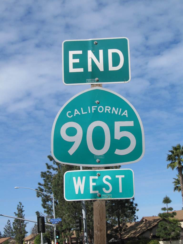
SR 905 is the connector between Interstate 5 near San Ysidro and the Otay Mesa Port of Entry (POE), with a connection to I-805, Otay Mesa and Brown Field. Formerly a mostly at-grade route, upgrades to limited access standards were made along the state route through the 1990s and 2000s as segments of freeway were funded and constructed along Otay Mesa Road. The final section of freeway opened to traffic on July 30, 2012, completing a high speed route from I-5 east to the Otay Mesa POE, the border crossing with Tijuana, Baja California, Mexico.
California State Route 905 Guides
California State Route 905 can be divided into five segments:
- Segment One - The unconstructed section between the International Border near Border Field State Park - this segment passes through some environmentally sensitive areas and will likely never be constructed.
- Segment Two - Between I- 5 and a point one half mile east of the Interstate 805.
- Segment Three - The last segment of freeway to open (July 2012), this segment connects Interstate 805 with Brittania Boulevard. The expressway segment was bypassed with the freeway opening.
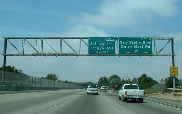
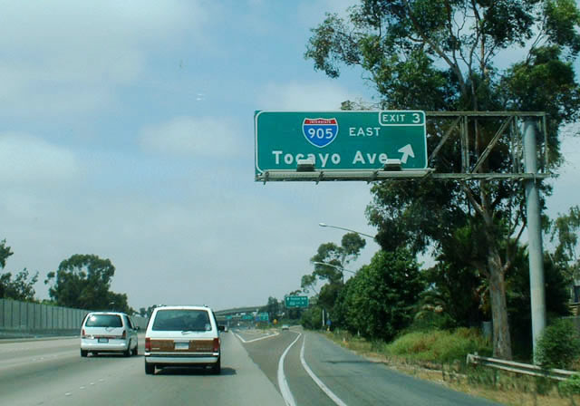
- Segment Four - The third freeway section opened (November 2010), this segment connects Brittania Boulevard with Segment Five near Airway Road, with a high speed interchange linking with SR 125 planned in the future.
- Segment Five - The second freeway section built (between 2005 and 2008 including the Siempre Viva Road interchange), this segment connects SR 125 and the Otay Mesa POE.
The following list provides a chronological history of California State Route 905:
- 1975 - SR 117 freeway under construction between Interstate 5 and Interstate 805. Plans call for the freeway to continue eastward to the Otay Mesa Port of Entry.
- 1984 - SR 905 commissioned to replace California 117, which was previously part of SR 75. Designation is changed to reflect future plans to add SR 905 into the Interstate Highway System. Since Otay Mesa Road between I-805 and the future SR 11/125 interchange is not maintained by Caltrans, this section was not signed as SR 905.
- 1997-1999 - The City of San Diego widens the existing Otay Mesa Road as a stop-gap measure until the full freeway is built parallel to and south of Otay Mesa Road. After this construction is completed, Otay Mesa Road will be maintained by the state until after the freeway is constructed in the new century.
- 1998 - SR 905 included in federal High Priority Corridor 30 in the hopes the designation would bring additional funding for the upgraded border crossing and freeway.
- 1999 - Initial Environmental Impact Reports were completed for the future 905 freeway; final documents were completed five years later.
- Spring 2000 - Work is completed on interim, temporary SR 905 expressway along Otay Mesa Road between Old Otay Mesa Road just east of Interstate 805 to the future SR 11/125 freeway interchange. This new expressway was built to Caltrans standards, with six lanes, Botts Dots, standard signage and a special fence-like median strip to prevent pedestrians from attempting to cross the highway. Signalized intersections with protected left turns were installed at Heritage/Otay Valley Road, Cactus Road, Britannia Boulevard, Alisa Court, La Media Road and Otay Mesa Road near the future California 125 interchange/connector. Planning continued for a permanent Interstate 905 freeway south but parallel to the existing SR 905 expressway. Traffic continued to escalate as all trucks were redirected to the Otay Mesa Border Crossing. The freeway segment was planned to begin between 2000 and 2004, according to the 2000 SANDAG Regional Transportation Plan.
- September 2004 - Final Environmental Impact Statement approved for the remainder of the freeway construction project.
- Spring 2005 - The SR 905 interchange with Siempre Viva Road was completed and opened to traffic.
- 2006 - the total project cost to complete SR 905 was $670 million; of this amount, $348 million was identified by early 2008.
- 2007 - Due to funding shortfalls, the project to finish SR 905 is divided into two phases: Phase 1A is the eastern segment of SR 905 from Siempre Viva Road to Britannia Boulevard, and Phase 1B is the western segment from Britannia Boulevard to just east of Interstate 805.
- January 2008 - Construction began on Phase 1A, from Siempre Viva Road to Britannia Boulevard.
- November 10, 2010 - Completion of Phase 1A with a grand opening ceremony.1 Phase 1B construction is underway, with anticipated completion of this phase in July 2012.2, 3
- July 30, 2012 - As scheduled, Phase 1B is completed, and the final link of SR 905 between Interstate 805 and Brittania Boulevard opens to traffic.7 Along with improvements to the I-805/SR 905 interchange, the final two phases were slated improvements to the Heritage Road and SR 125 interchanges at a cost of approximately $163 million.
In an agreement inked between the City of San Diego and Caltrans from 1998, the City paid to upgrade Otay Mesa Road to six lanes with turning lanes by the end of 1999, and Caltrans would maintain the road as a temporary state facility until the SR 905 freeway was built. Construction was completed in early 2000, and signs for SR 905 were erected shortly thereafter.
Once the SR 905 freeway was completed it was to be redesignated as Interstate 905, per an agreement between the FHWA, Caltrans, and SANDAG.4,5 SR 905 was previously approved as an Interstate by AASHTO in 1984. Otay Mesa Road, which served as the temporary alignment of SR 905, was returned to city of San Diego control following completion of the freeway.6
With the opening of Segments 3 and 4, the following improvements were proposed for the corridor as defined by Caltrans:2
- Phase 2 - Improvements to the I-805/SR 905 Interchange
- Phase 3 - Construct SR 125/SR 905 direct access/systems interchange
- Phase 4 - Construct Interchange at Heritage Road
The controversy surrounding SR 905 was the completion of the missing freeway link of Segments Three and Four. City of San Diego officials constructed the interim expressway as a temporary fix to close the gap (until the final freeway alignment opened in July 2012). The original Otay Mesa Road was an under-developed City street that became California's busiest trade route with Mexico. People wanted Otay Mesa Road upgraded to expressway or freeway status for several reasons:
- The road was designed for a maximum of 35,000 vehicles a day, but traffic often exceeds 50,000 vehicles.
- From 1990 until around 1998, 25 people had been killed and 350 others injured on the five mile eastern stretch of Otay Mesa Road that runs just south of the Brown Field cargo airport and across rolling hills, between Interstate 805 and the Mexican border.
- The Federal Government opened the Otay Mesa Port of Entry, approved the North American Free Trade Agreement (NAFTA), and shifted all cross-border truck traffic onto the road in a span of fifteen years. Prior to these actions, Otay Mesa Road only handled 4,300 vehicles per day.
As a short-term solution, the City of San Diego and Caltrans appropriated $17 million in Fiscal Year 1998 to widen Otay Mesa Road to three lanes each way, add a concrete median and widen the shoulders. This was approved in December of 1994. The City and Caltrans hoped to begin work by 1995, but an Environmental Impact Study was required. Construction did not begin until August 1997, and it was delayed at several points. It was completed by late 1999/early 2000.
Funds to build the future SR 905 freeway (Segments Three and Four) were secured in the late 2000s. This allowed a new freeway to be built parallel to the existing Otay Mesa Road and provide six to eight lanes of traffic between Interstate 805 and SR 125. In August 1997, U.S. Representative (Pa.) Bud Shuster, chairman of the House Transportation Committee, visited the border region and pledged to help secure money to complete the SR 905 freeway. Route 905 was listed as a High Priority Corridor in BESTEA, the House-approved ISTEA Reauthorization bill, and it was finally added to the final TEA-21 bill signed into law in 1998.
Funding for the SR 905 freeway was difficult to obtain. In the mid-1990s, state and federal officials were not even sure whether to build a $130 million four-lane expressway or a $255 million six-lane freeway (figures from the 2000 SANDAG Regional Transportation Plan). The feasibility study and Major Investment Study for the SR 905 freeway were completed in spring 1998, and the Environmental Impact Study was made public in 1999.
 | Brittania Boulevard south linked SR 905 east from Otay Mesa Road to the Otay Mesa Freeway until 2012, when the remaining freeway segment opened to traffic. 07/10/16 |
 | Brittania Boulevard south at the diamond interchange and then-temporary west end of the Otay Mesa Freeway leading east to the international border. 02/21/11 |
 | Leaving the intersection with Otay Mesa Road, La Media Road travels south first to intersect with SR 905 west and then proceed to the Truck Border Crossing. 02/21/11 |
 | La Media Road south at the parclo B2 interchange with SR 905 (Otay Mesa Freeway). 02/21/11 |
 | Siempre Viva Road east at the parclo interchange with SR 905. 07/19/14 |
 | Freeway entrance assembly for the westbound ramp leading from Siempre Viva Road toward the adjacent SR 905 partition with SR 125 north. 07/19/14 |
- "Ceremony to mark completion of key leg of I-905." San Diego Union-Tribune, November 9, 2010.
- State Route 905 Fact Sheet - February 2010
http://www.dot.ca.gov/dist11/facts/SR-905_feb2010.pdf - State Route 905/125 Interchange at Otay Mesa Port of Entry
http://www.dot.ca.gov/dist11/departments/planning/pdfs/systplan/ 26-TransportationBorderCongestionReliefProgramApplicationSR905125InterchangeOtayMesaPOE.pdf, Transportation Border Congestion Relief Program Application, California Department of Transportation, June 2008 - A San Diego Association of Governments (SANDAG) brochure states that when the SR 905 freeway is completed, "SR-905 WILL BE DESIGNATED AS I-905, as part of an obligation that is included in an agreement between the FHWA and the State of California." This brochure came out in the late 1990s.
- "U.S. grants $20.2M for Otay Mesa interchange improvements." San Diego Union-Tribune<,/em> October 4, 2010.
- Adoption of a Traversable Highway: Resolution HRA 02-01 11-SD-905 KP T10.3/16.9E (PM T6.4/10.5E) dated October 1, 2001, by Mark Leja. On page 3, under the Conclusion section: "When the Route 905 freeway is opened to traffic, Otay Mesa Road will be relinquished to the City of San Diego pursuant to the terms in the Cooperative Agreement dated December 10, 1996."
- "SR-905 opens, connects 805 to Otay Mesa border entry." CBS 8, July 30, 2012.
Photo Credits:
02/21/11, 07/19/14, 07/10/16 by AARoads
Connect with:
Interstate 5
Interstate 805
Page Updated 08-28-2017.