
Interstate 480, better known as the Embarcadero Freeway, connected I-80 (San Francisco-Oakland Bay Bridge) with Downtown San Francisco via a double-decked freeway that followed today's Embarcadero. The only section that was constructed opened in 1959, and it was signed as I-480 between 1959 and 1965.
The two pronged freeway was constructed with even grander plans for the ultimate route of Interstate 480. According to a 1964 official map of California, I-480 was to continue northwest past the Broadway exit to meet U.S. 101 and I-280 near the Golden Gate Bridge. The 1964 map showed I-480 following the Embarcadero northwest to near Lombard Street, then along Lombard Street and Richardson Street west to the foot of the Golden Gate Bridge. An interchange was proposed with U.S. 101 (Central Freeway) near the current intersection of Lombard Street and Van Ness Avenue.
There would have been a major interchange on Doyle Drive connecting I-480 and U.S. 101 with California 1 and the proposed Interstate 280 at the south end of the Golden Gate Bridge. Interstate 280 was proposed to follow California 1 on a corridor roughly parallel to Seventh Avenue and Park Presidio Boulevard at that time. Some maps also showed Interstate 480 as the designation of the unconstructed section of I-280 between the Golden Gate Bridge approach (Doyle Drive) and the present interchange joining I-280 with California 82.
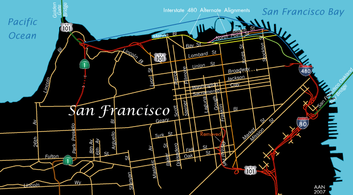
However, such grandiose plans for Interstate 480 never came to pass. A freeway revolt started in the late 1950s and early 1960s caused most freeway construction within the city of San Francisco to grind to a halt. Resulting changes included shifting the northern end of Interstate 280 toward the San Francisco-Oakland Bay Bridge and downgrading I-480 to California 480 because the Embarcadero Freeway was truncated at the Sansome Street/Battery Street couplet near Broadway in 1965. Ultimately, the majority of the freeway was never built due to opposition from the San Francisco City Council and many residents of the "City by the Bay."
The Embacadero Freeway was one of several double-decked freeways built in the San Francisco Bay Area. The upper deck carried southbound traffic and the lower deck SR 480 northbound. Other double deck freeways included parts of U.S. 101 (Central Freeway) and the Cypress Viaduct on Interstate 880 in Oakland that collapsed in 1989. Only a short stretch of I-280 northeast of U.S. 101 remains double decked today.
The California 480 freeway obstructed views of San Francisco Bay from the financial district, and its two levels dominated the skyline of the city as seen from the bay and Yerba Buena Island. People complained about the look of the hulking concrete structure. Although it served a key function in moving traffic through Downtown, it came at a price of cutting off the city from its bay, and it also left the waterfront largely ignored. The San Francisco city council worked to get the freeway condemned to restore and redevelop the waterfront, with an action in 1985 helping to move in that direction. The freeway did not close until 1989, when the Loma Prieta Earthquake made the structure unsafe for use.
Although some think that the Embarcadero Freeway collapsed in the 1989 Loma Prieta earthquake, in actuality SR 480 suffered relatively minor damage. However, the cost to repair and retrofit the structure would have been enormous, plus the 1985 city council vote already advocating removing it. So, within two years, SR 480 was decommissioned. The state took action in 1991, demolishing the elevated freeway. Redevelopment efforts followed, with a tree-lined boulevard, light rail and walkway built along the along the former freeway corridor.
Until 2005, the Fremont Street / Folsom Street exit from westbound Interstate 80 was the only remaining section of the Embarcadero Freeway. The former ramp connecting I-80 east to what was SR 480 north was blocked from use by that time. A subsequent reconstruction project along the James Lick Skyway replaced all ramps to Downtown, including the few remnant structures left of from the Embarcadero Freeway.
These web sites offer more on the background of former Interstate 480 in California:
- I-480 (cancelled) California by Scott Oglesby
- California Highways: Former State Route 480 by Daniel Faigin
- Notorious SF: Freeway Revolt (by Hank Donat)
Page Updated 06-21-2018.