
SR 72 forms a 17.52 mile arc north from SR 9 and the Delaware City refineries, to SR 7 (Limestone Road) in the Upper Pike Creek Valley, by way of Newark. The state route carries four lanes along the 0.22 mile overlap with U.S. 13 between Wrangle Hill and SR 1, and from Old Baltimore Pike north through Newark, to the east split with SR 2 (Capitol Trail) at Liberty Plaza shopping center.
The state route follows Wrangle Hill Road northwest from near Delaware City through suburban areas of Bear-Glasgow to U.S. 40 (Pulaski Highway). North from Frasers Corner, Sunset Lake Road continues SR 72 by Sunset Lake Preserve to Old Baltimore Pike. South Chapel Street then expands the route into a five-lane boulevard northward by an array of industrial parks beside the Interstate 95 overpass.
South Chapel Street intersects SR 4 (Chestnut Hill Road) at Pencader Shopping Center, just outside the Newark city limits. Northward, Library Avenue shifts the route east across the AMTRAK Northeast Corridor to the couplet of SR 273 (Delaware Avenue / Main Street). Between 1988 and 2013, SR 2 overlapped with SR 72 north from Chestnut Hill Road to East Main Street in Newark as part of its bypass of Newark. SR 2 (Capitol Trail) was truncated to begin at Capitol Trail and East Main Street in fall 2013. Capitol Trail takes both routes east 1.20 miles to Possom Park Road, just beyond the Newark city line.
Rising over 250 feet in elevation, Possum Park Road angles SR 72, 1.9 miles northwest to Milford Crossroads, where Paper Mill Road and Thompson Station Road come together. Paper Mill Road turns SR 72 northeast between White Clay Creek State Park, Middle Run Natural Area, and Paper Mill Road to Polly Drummond Hill Road. Pike Creek Valley subdivisions line the remainder of the state route east to its conclusion at Limestone Road.
The Delaware Department of Transportation (DelDOT) SR 72, McCoy Road to SR 71 project expanded SR 72 to a five lane boulevard from McCoy Road, west of SR 1, to Willamette Drive, north of SR 71 (Red Lion Road). Construction got underway in Summer 2022 on the four-phase project. The bulk of work was completed by Summer 2024, with work on final punch-list items in Phase 4 extending to Spring 2025.
Delaware State Route 72 Guides
Designated by 1942, SR 72 measured 9.5 miles in length north from SR 273 (Delaware Avenue / Main Street) in Newark to SR 7 (Limestone Road) in the Pike Creek Valley. The state route followed Chapel Street and Pike Creek Road north to Milford Crossroads, and the current alignment from there to Limestone Road.
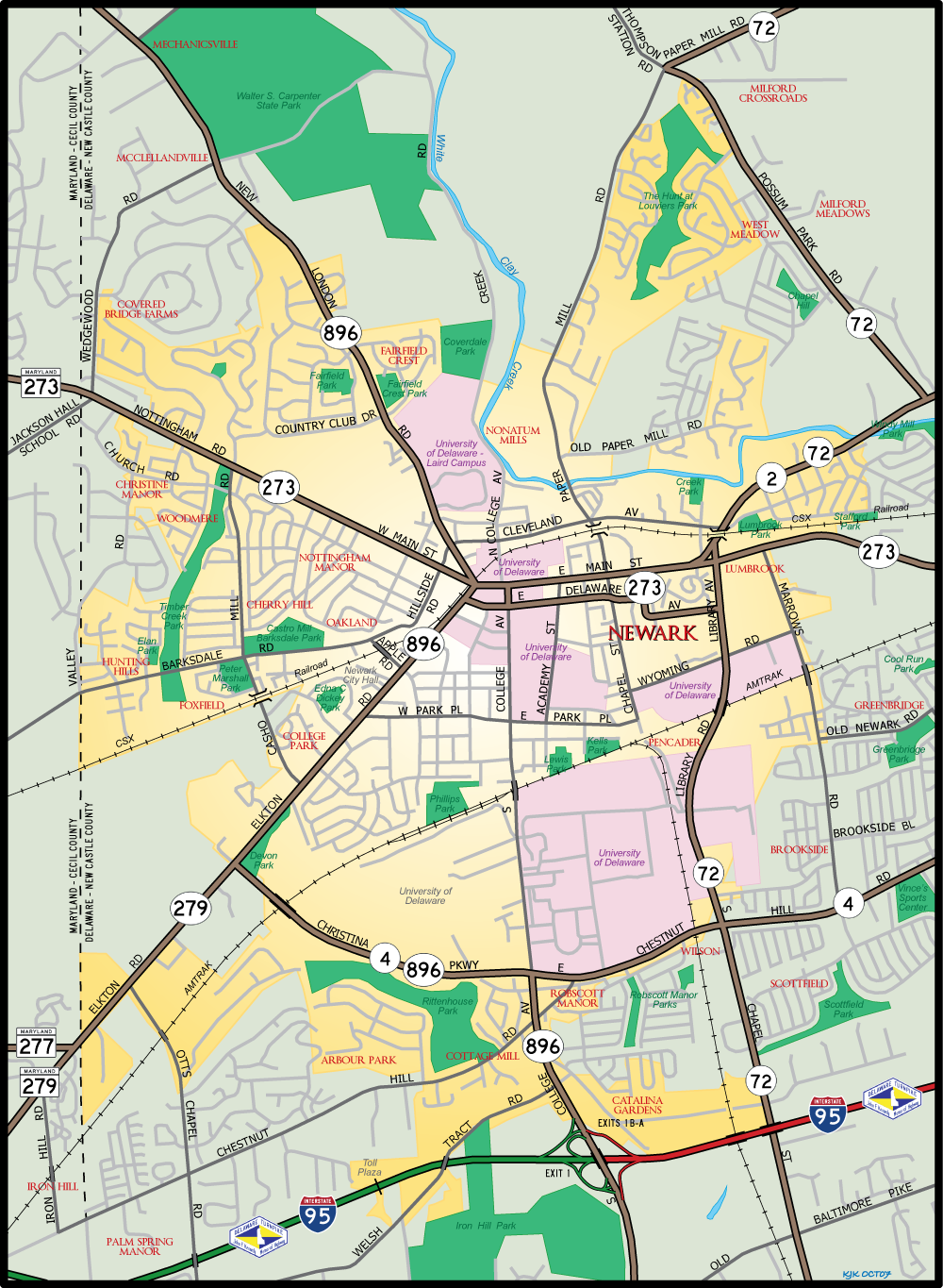
SR 72 was extended south along South Chapel Street and Sunset Lake Road from Newark to U.S. 40 and southeast along Wrangle Hill Road to SR 9 by 1967. The route through Newark changed by 1979, with a new alignment (Library Avenue) and bridge over the AMTRAK Northeast Corridor constructed east from South Chapel Street to the curve of eastbound SR 273 (Delaware Avenue) at College Square Shopping Center. Library Avenue replaced the accident prone AMTRAK grade crossing along Chapel Street. Closure of the crossing made Chapel Street discontinuous south of East Park Place, with Wyoming Road built to provide connectivity with the new SR 72 to the east.
Delaware State Route 72 - 2015 Annual Average Daily Traffic (AADT)
- 5,636 - SR 9 to U.S. 13
- 23,483 - SR 1 to SR 71
- 16,646 - Porter Road to U.S. 40
- 18,156 - Reybold Road to Old Baltimore Pike
- 32,733 - Old Baltimore Pike to Delaware Industrial Park
- 34,189 - SR 4 to south Newark limits
- 39,279 - SR 273 to Cleveland Avenue
- 13,534 - SR 2 to Old Possom Park Road
- 17,144 - Thompson Station Road to Corner Ketch Road
- 17,026 - Corner Ketch Road to SR 7
 scenes scenes |
 | Wyoming Road (Road 365E) leads 0.30 miles west from Marrows Road between The Grove at Newark mixed used development and Delaware Technology Park to SR 72 (Library Avenue) in Newark. 12/24/22 |
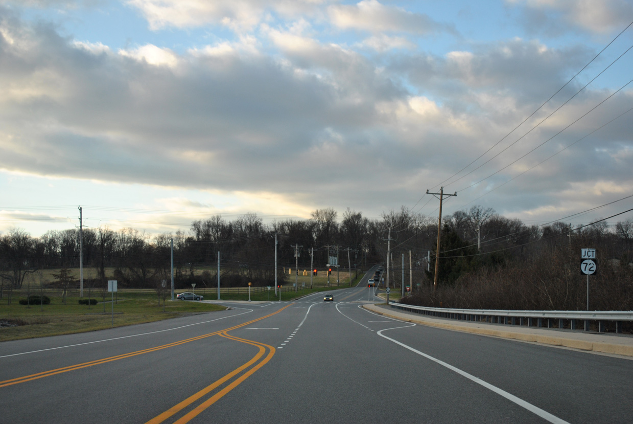
 | Thompson Station Road exits White Clay Creek State Park and approaches the turn of SR 72 from Paper Mill Road to Possum Park Road at Milford Crossroads. 06/25/10 |
  | Polly Drummond Hill Road north at SR 72 (Paper Mill Road) and Corner Ketch Road in the Upper Pike Creek Valley. 12/22/12 |
Photo Credits:
06/25/10, 12/22/12, 12/24/22 by AARoads
Connect with:
U.S. 13
State Route 1
State Route 2
State Route 4
State Route 7
State Route 9
State Route 71
State Route 273
Page Updated 01-07-2025.