The city of Deltona originated as a Mackle Brothers idea of a master-planned community for retirees in 1962. Work broke ground and by April 1963, Deltona welcomed its first residents. Incorporation however did not occur until December 31, 19951 and as of the 2020 Census, Deltona was home to 93,692.
DeBary incorporated in 1993 to prevent annexation by Orange City to the north.2
Orange City, incorporated in 1882, was started by Dr. Seth French and company in 1874 with a purchase of 5,000 acres. The town derives its name from the thousands of orange trees planted in the area.3
Henry A. DeLand founded Lake Helen in 1883. The community was named after his daughter Helen.5
|
| Traversing areas of low lying wetlands and marshes, Interstate 4 straddles the western shore of Lake Shore in western Volusia County. 02/12/24 |
|
| Interstate 4 east connects with the c/d roadway along I-95 north ahead of U.S. 92 in 26.8 miles from this distance sign. The city center of Daytona Beach is 32.6 miles away via U.S. 92 (International Speedway Boulevard) east from I-95. 09/11/22 |
|
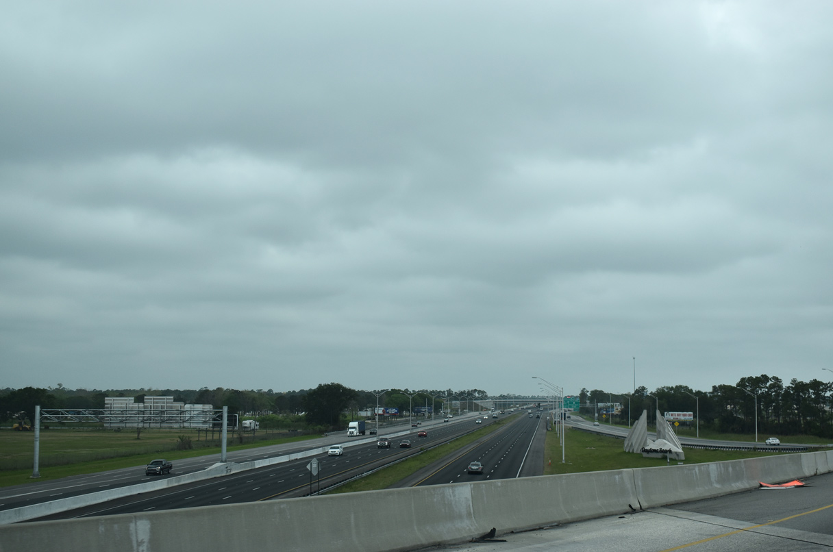
| I-4 separates DeBary to the west and Deltona to the east, expansive suburban cities spreading across the majority of the surrounding area. 02/12/24 |
|
| Completed in July 2010, an arterial bypass takes CR 4162 (DeBary Avenue) around unincorporated Enterprise just east of Interstate 4. 02/12/24 |
|
| The folded diamond interchange at Exit 108 joins I-4 with CR 4162 along Dirksen Drive west through DeBary and DeBary Avenue east through south Deltona. 02/12/24 |
|
| DeBary Avenue meanders east from Lake Monroe and Enterprise to Providence Boulevard (CR 4155). CR 4162 continues from there along Doyle Road to Osteen. 02/12/24 |
|
| Dirksen Drive (CR 4162) heads 2.1 miles west along Gemini Springs Park to U.S. 17/92 (Charles Beall Boulevard). Central DeBary lies one mile north of there. 02/12/24 |
|
| Enterprise Road (unsigned CR 4156) angles northwest from the DeBary Avenue bypass (CR 4162) to span I-4 beyond this eastbound shield assembly. 09/11/22 |
|
| Road Ranger service continues along Interstate 4 northeast from Sanford throughout Volusia County. 09/11/22 |
|
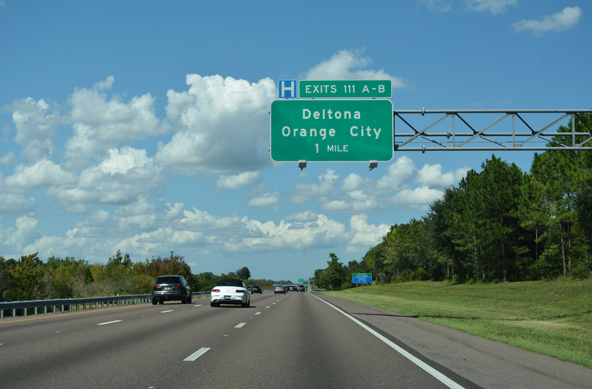
| DeBary gives way to Orange City west of I-4 at Exit 111. Joining the freeway at a three quarter cloverleaf interchange in one mile is CR 4146 (Saxon Boulevard). Saxon Boulevard stems two miles east from U.S. 17/92 (Charles Beall Boulevard / Volusia Avenue) to I-4 in south Orange City. 09/11/22 |
|
| Exit 111 A joins Interstate 4 east with CR 4146 (Saxon Boulevard) east to central Deltona. Saxon Boulevard meanders southeast to CR 4162 (Doyle Road) at the south end of the city. 09/11/22 |
|
| Six lane expansion along I-4 through the vicinity of Deltona was completed in 2007. Saxon Boulevard comprises a suburban boulevard arcing southeast from Exit 111 A three miles to CR 4155 (Providence Boulevard). 09/11/22 |
|
| Exit 111 B loops onto Saxon Boulevard west to Orange City and DeBary. Saxon Boulevard west to Enterprise Road north connects with U.S. 17/92 north to the Orange City business district. 09/11/22 |
|
| Reassurance marker posted north of Saxon Boulevard. The exit with CR 4146 was not an original I-4 interchange. 09/11/22 |
|
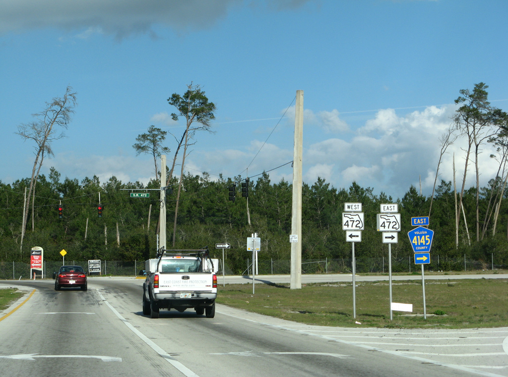
| The ensuing exit along Interstate 4 east is the parclo interchange with SR 472 (Howland Boulevard) along the Orange City and Deltona city line. 09/11/22 |
|
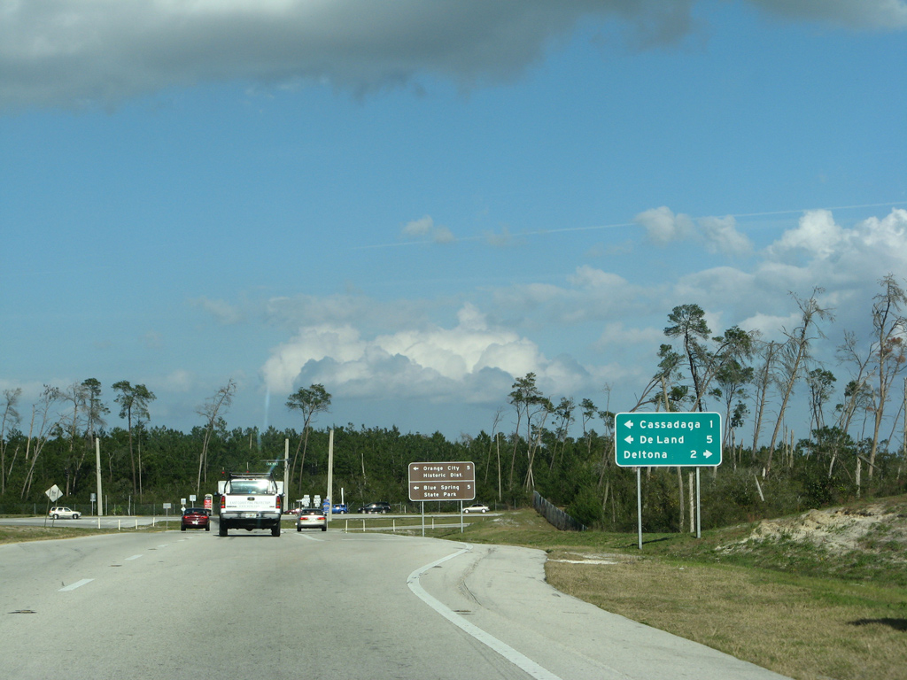
| The east end of SR 472 ties into CR 4145 (Graves Avenue) at Howland Boulevard. CR 4145 extends 2.74 miles west to U.S. 17/92 and the Orange City Historic District. 09/11/22 |
|
| SR 472 constitutes a 3.41 mile long controlled access route from Graves Avenue (CR 4145) in Deltona northwest to U.S. 17/92 south of DeLand. 09/11/22 |
|
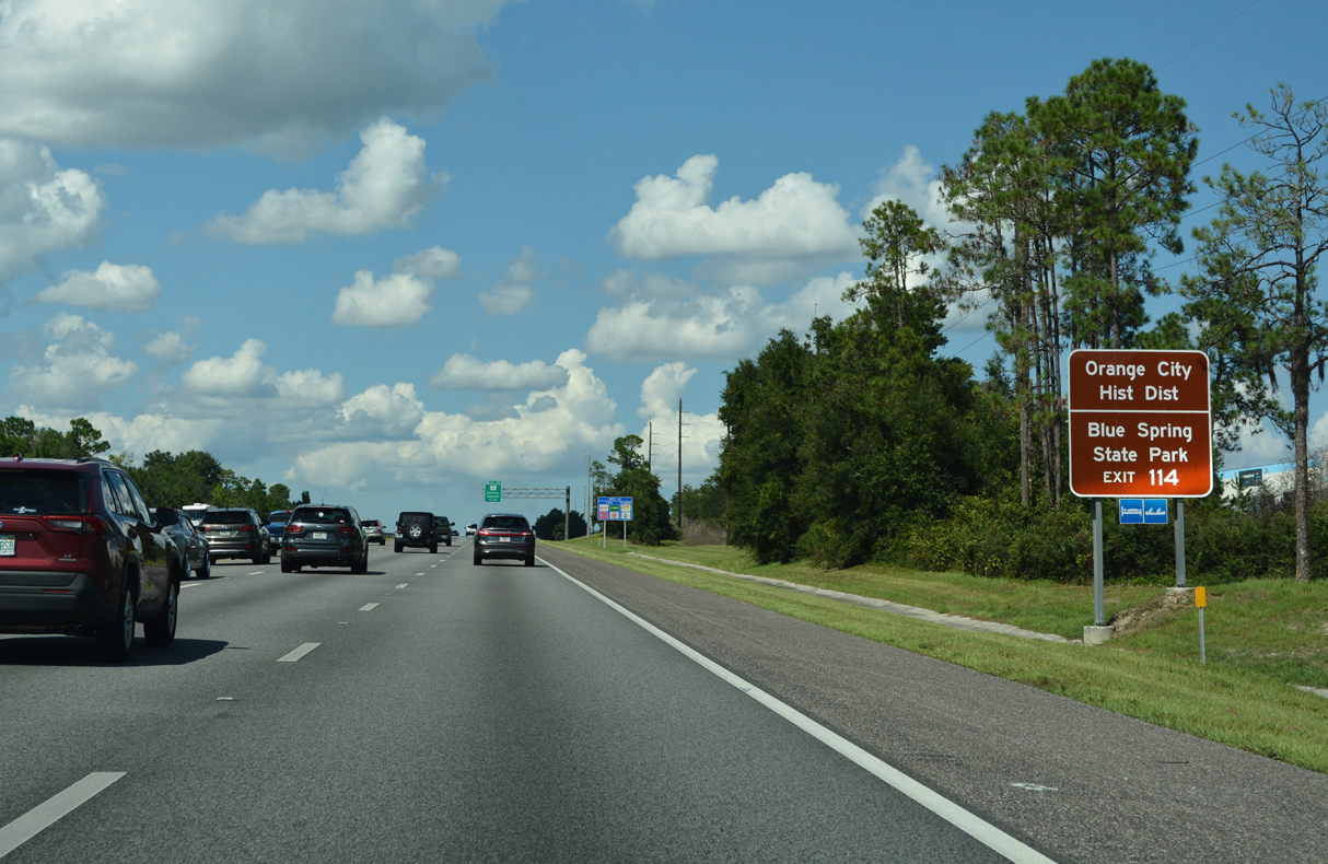
| Howland Boulevard (CR 4145) continues 8.64 miles southeast from SR 472 and Exit 114 across Deltona to SR 415. 09/11/22 |
|
| Blue Spring State Park lies 2.10 miles beyond U.S. 17/92 and Orange City along W French Avenue (CR 4142). 02/17/08 |
|
| Originally a trumpet interchange joined I-4 with what was the south end of State Road 472. Construction in the mid 2000s expanded the exchange with an extension of Howland Boulevard north. 02/17/08 |
|
| CR 4139 (Cassadaga Road), formerly SR 430A, spans Interstate 4 beyond this shield marker. 09/11/22 |
|
| CR 4116 (Orange Camp Road / Main Street) converges with Interstate 4 at a parclo B2 interchange (Exit 116) along the DeLand / Lake Helen city line. Orange Camp Road leads west one mile to a roundabout with CR 4101 (Dr. Martin Luther King, Jr. Beltway) and 2.89 miles to U.S. 17/92 (Woodland Boulevard). 09/11/22 |
|
| Main Street (CR 4116) east to CR 4139 (Lakeview Drive) south leads to the unincorporated community of Cassadaga, the self proclaimed "Psychic Center of the World." 09/11/22 |
|
| Exit 116 leaves Interstate 4 eastbound for Orange Camp Road west and Main Street east. CR 4116 concludes 0.89 miles east of Interstate 4 at Lakeview Drive (CR 4139) just off Lake Helen. 09/11/22 |
|
| Interstate 4 runs across northwestern reaches of Lake Helen toward the County Road 4139 (Summit Avenue) overpass. 09/11/22 |
|
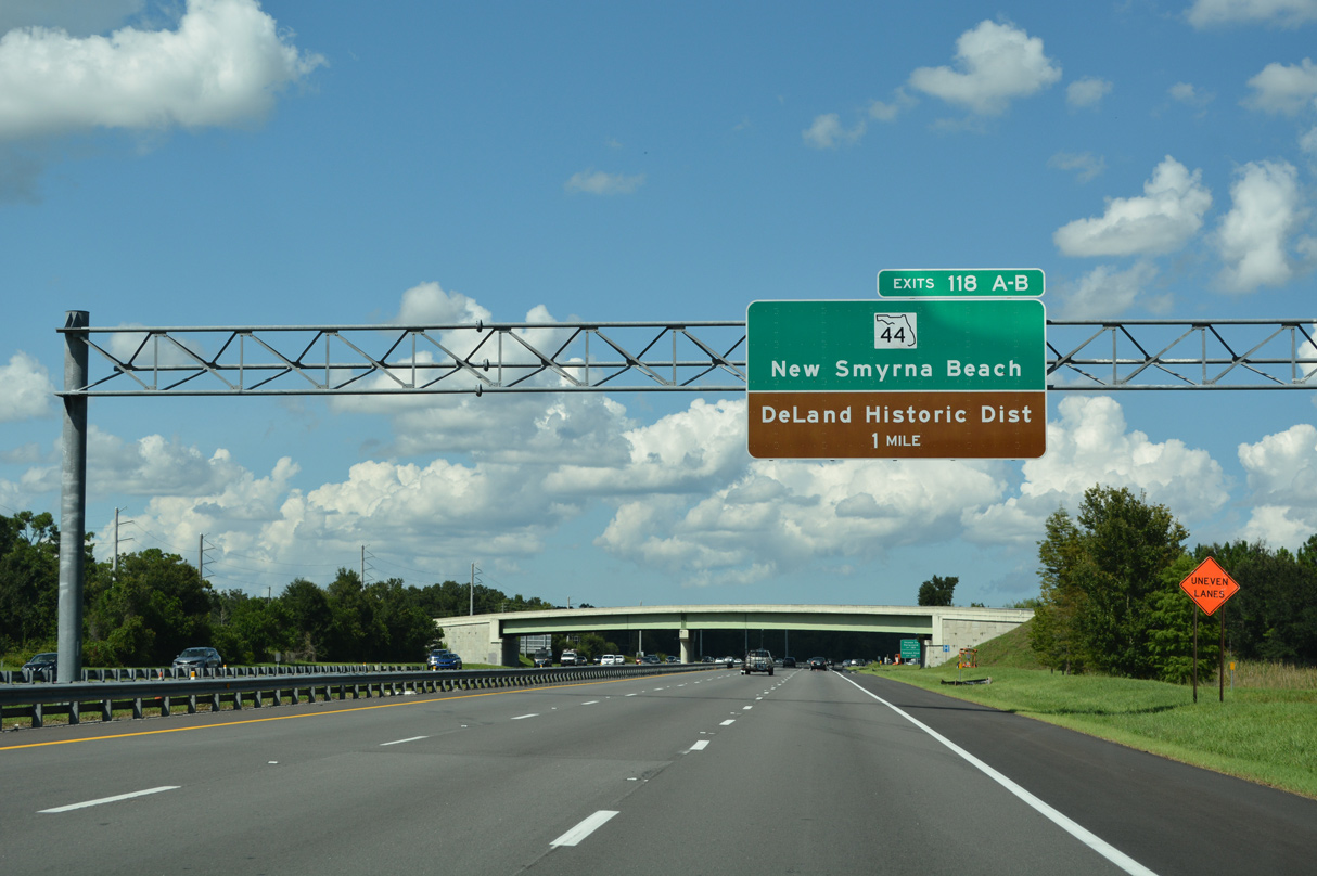
| Curving northeast, I-4 next meets SR 44 (New York Avenue) at Exits 118 A/B, north of Lake Helen and east of DeLand. SR 44 joins Downtown DeLand with New Smyrna Beach on the coast.
Six lane widening of I-4 north to SR 44 finished in August 2008 included expansion of the parclo B2 interchange at Exit 118 with two additional ramps. 09/11/22 |
|
| Interstate 4 east previously reduced to two through lanes with a lane drop at SR 44. Construction underway from 2013 to 2017 widened the freeway north to Daytona Beach.
Exit 118 A joins I-4 east with the adjacent Volusia County Fairgrounds. Exit 118 B leads west toward Stetson University. 09/11/22 |
|
| SR 44 (New York Avenue) encircles Lake Winnemissett west to Kepler Road (CR 4101) before straightening out ahead of the DeLand street grid. The DeLand historic district is centered around the intersection of New York Avenue and U.S. 17/92 (Woodland Boulevard). 09/11/22 |
|
| Exit 118 A leaves a distributor roadway for SR 44 east 19 miles to U.S. 1 in New Smyrna Beach. These overheads were installed in 2019. 09/11/22 |
|
| A 9.6 mile exit less stretch along Interstate 4 commences northeast from SR 44 and DeLand toward toward Daytona Beach. The freeway traverses wetland areas at Deep Creek Swamp and Tiger Bay along this stretch. 09/11/22 |
|
| The connection with I-95 north toward the First Coast lies 12.7 miles beyond this distance sign. The Daytona Beach city center is 19 miles to the northeast via I-4, I-95 and U.S. 92 (International Speedway Boulevard). 09/11/22 |
|
| Completed in Spring 2017 at a cost of $143 million, the 12.34 mile long expansion project on Interstate 4 in Volusia County rebuilt the freeway with a concrete surface. Running along the south side of Tiger Bay State Forest, three animal crossings were also added.6 09/11/22 |
|
| A wye interchange (Exit 129) links Interstate 4 east with the connector to parallel U.S. 92 (International Speedway Boulevard) east in one mile. 09/11/22 |
|
| U.S. 92 parallels I-4 a half mile to the north while en route to Daytona International Speedway and Daytona Beach International Airport (DAB). 09/11/22 |
|
| Widening of I-4 between SR 44 (New York Avenue) and Interstate 95 included changing the left exit for U.S. 92 to a right side exit.6 09/11/22 |
|
| U.S. 92 (International Speedway Boulevard) extends another 8.7 miles from the ramps at Exit 129 through central Daytona Beach to conclude at SR A1A (Atlantic Avenue). 09/11/22 |
|
| The last eastbound confirming marker for Interstate 4. 09/11/22 |
|
| The first in a series of arrow per lane signs for the systems interchange with Interstate 95 appears two miles out. I-95 passes through western reaches of Daytona Beach, Port Orange, and many other beach cities throughout Volusia County and the entire Florida east coast. 09/11/22 |
|
| A $205 million project underway through late 2018 Spring 2020 along I-95 redesigned the exchange with I-4 into a wider footprint. The roadways linking with SR 400 were realigned and ramps between the freeways were relocated to connect with new c/d roadways along Interstate 95.7 09/11/22 |
|
| SR 400 extends 4.20 miles east from I-4/95 to U.S. 1 (Ridgewood Avenue) along an arterial route on the Daytona Beach and South Daytona city line. 09/11/22 |
|
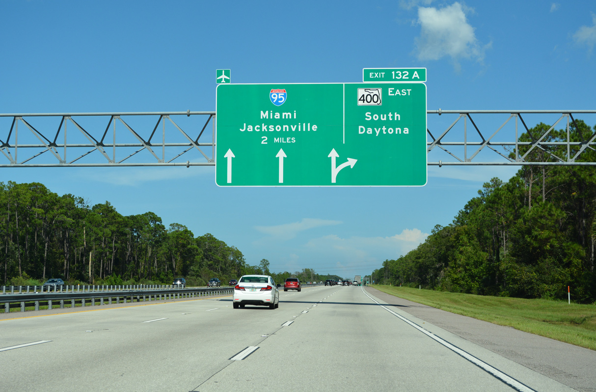
| I-4 east defaults onto Interstate 95 north through Daytona Beach toward Jacksonville. The Systems Interchange project built an extended ramp (Exit 132 A) from I-4 east to SR 400 (Beville Road) and South Daytona. This was previously Exit 132. 09/11/22 |
|
| Embry-Riddle Aeronautical University is a part of the Daytona Beach International Airport (DAB) complex north of SR 400 via SR 483 (Clyde Morris Boulevard). 09/11/22 |
|
| The Museum of Arts and Sciences lies north of SR 400 (Beville Road) along SR 5A (Nova Road). 09/11/22 |
|
| Exit 132 A departs I-4 east for SR 400 to the city of South Daytona. Interstate 95 connects Daytona with the Melbourne and the Space Coast, Fort Pierce and the Treasure Coast and West Palm Beach, Fort Lauderdale and Miami in South Florida. 09/11/22 |
|
| The ramp to I-95 south at Exit 132 B combines with a ramp from SR 400 west. I-95 travels south four miles to SR 421 at Port Orange and 258 miles to Downtown Miami. 03/26/20 |
|
| I-4 east connects with the northbound c/d roadway along I-95 ahead of Exit 260 C for U.S. 92 (International Speedway Boulevard) in Daytona Beach. 03/26/20 |
|
| Signs identifying each ramp at the I-4/95 systems interchange are posted along all connections. This assembly follows the loop ramp from I-95 south to SR 400 East. 09/12/22 |
|
| The eastbound roadway from Interstate 4 transitions onto SR 400 (Beville Road) just ahead of CR 4009 (Williamson Boulevard) north to Daytona Beach International Airport (DAB). 09/11/22 |
|
| An end Interstate 4 / begin SR 400 shield assembly precedes a gas station and Andros Isles Boulevard along Beville Road eastbound. 09/12/22 |


Sources:
- City of Deltona - General Information - City History.
http://cideltona.zgraph.com/ 2001/generalinfo/history.html
- DeBary, Florida. Wikipedia.org.
- City of Orange City, Florida -- Orange City Town History.
http://www.ci.orange-city.fl.us/ index.asp?Type=B_BASIC&SEC=%7B3A 964F0C-F92B-43E6-8947-0B107833C839%7D
- City of DeLand, Florida - Virtual Tour - The History of DeLand
http://www.deland.org/ tour/history_overview.htm. City of DeLand, web site.
- Lake Helen, Florida - Community Information of Lake Helen Florida.
http://www.volusia.com/ lakehelen/
- I-4 Widening from SR 44 (East New York Avenue) to East of I-95 - 408464-1.
http://www.cflroads.com/project/408464-1/ I-4_widening_from_SR_44_to_East_of_I-95 Florida Department of Transportation (FDOT) District 5, project web site.
- I-95 Widening and Systems Interchange Reconstruction Design-Build from North of S.R. 44 to North of U.S. 92 - 242715-2. Florida Department of Transportation (FDOT) District 5, project web site.
- 02/17/08 by AARoads.
- 03/26/20 by AARoads.
- 09/11/22 by AARoads.
- 09/12/22 by AARoads.
- 02/12/24 by AARoads and JP Nasiatka.
Connect with:
Interstate 95
U.S. 92
State Road 400 - Beville Road
State Road 472
Volusia County Road 4116
Volusia County Road 4146
Page Updated 02-13-2024.

 East
East