|
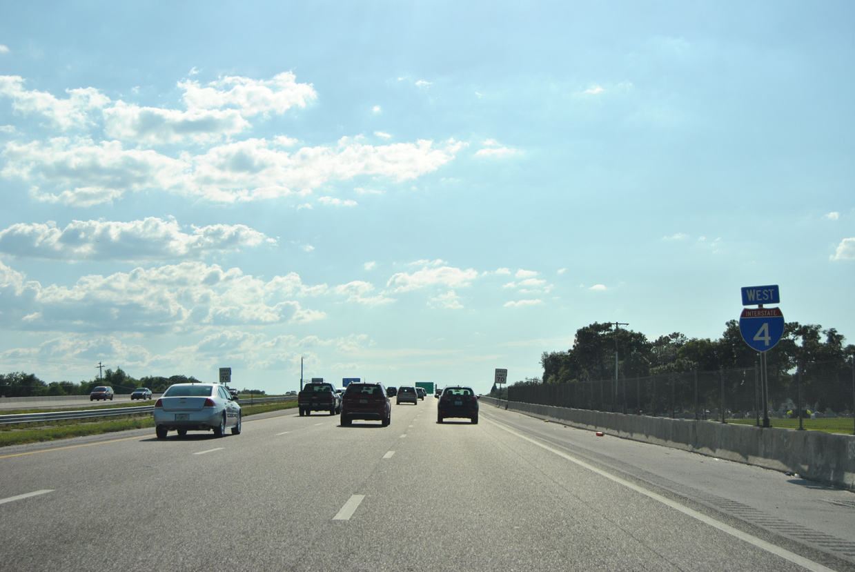
| Reassurance marker posted beyond the folded diamond interchange with County Line Road at Mt. Enon. A pair of frontage roads accompany I-4 from Lakeland west to Plant City. 05/15/16 |
|
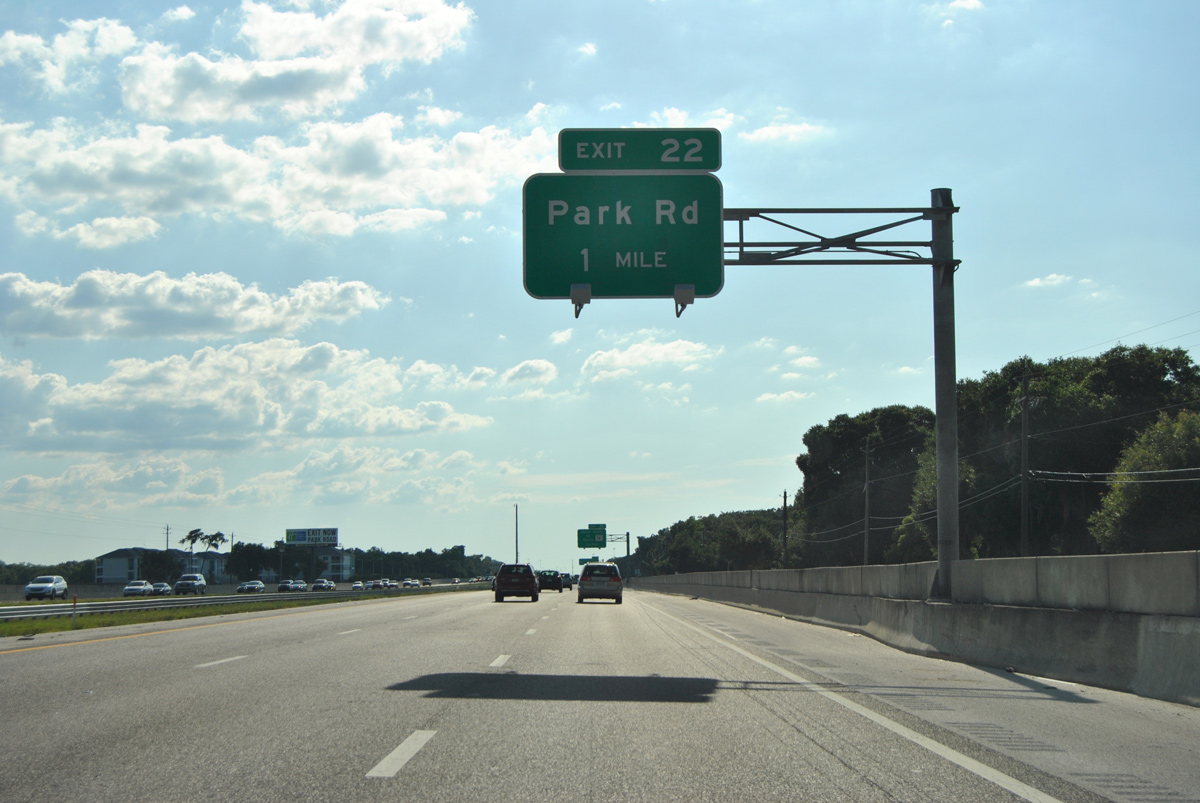
| Park Road serves Plant City Stadium, Hillsborough Community College and eastern reaches of Plant City. Wheeler Street (CR 39) extends south from Paul Buchman Highway (SR 39A) to Downtown while SR 39 (Alexander Street) and SR 566 (Thonotosassa Road) serve western reaches of Plant City. 11/04/17 |
|
| Omitted from Exit 22 guide signs in both directions, State Road 553 lines Park Road 1.41 miles south from I-4 to U.S. 92 (Baker Street). 05/15/16 |
|
| Park Road forms the east truck bypass for Plant City south from I-4 to James L. Redman Parkway (former SR 39) and north to parallel CR 580 (Sam Allen Road). SR 39 overtakes James L. Redman Parkway south from Alexander Street to SR 60 at Hopewell. 11/04/17 |
|
| Interstate 4 west enters the diamond interchange (Exit 22) with SR 553 south and unsigned CR 580 north along Park Road. 05/15/16 |
|
| Reassurance marker posted west of the Park Road (SR 553) entrance ramp. 05/15/16 |
|
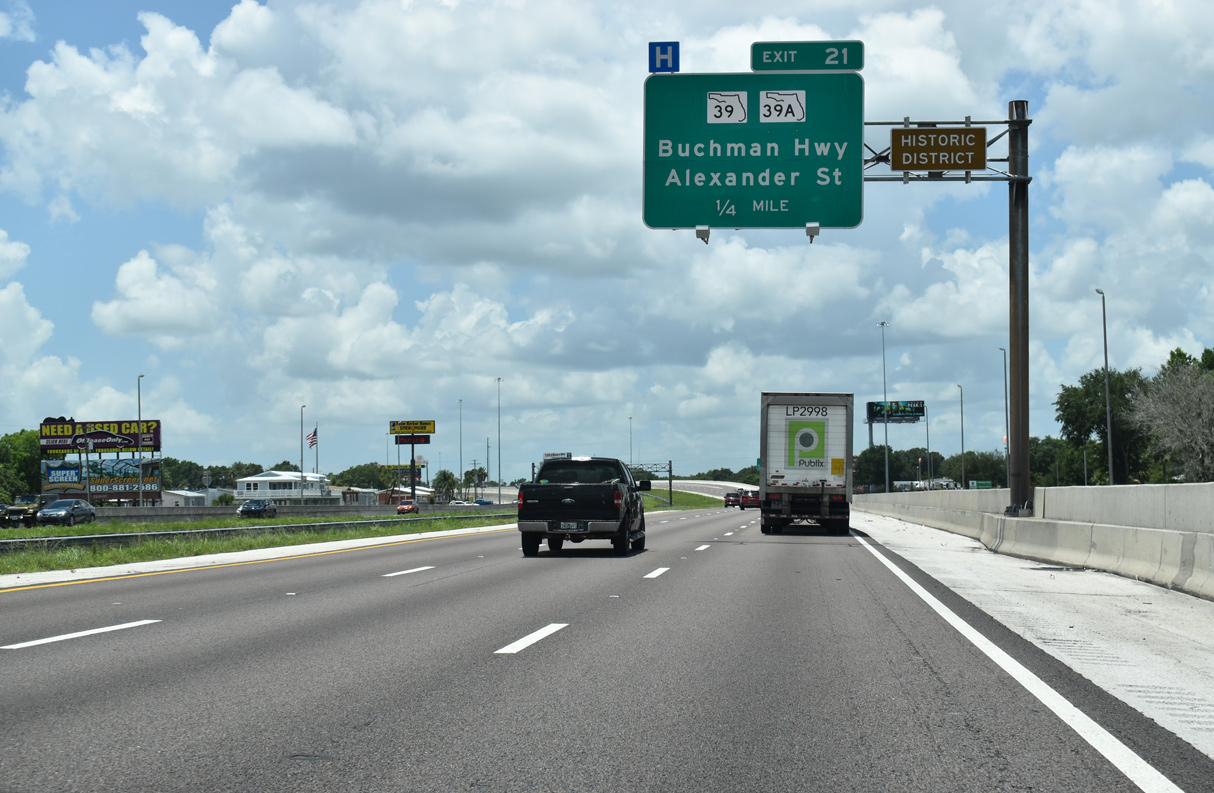
| SR 39 is the main route between Plant City and Zephyrhills in Pasco County. The route was realigned in December 2013 onto a 2.5 mile long extension of N Alexander Street from Exit 21 to Paul Buchman Highway near Knights. 06/02/18 |
|
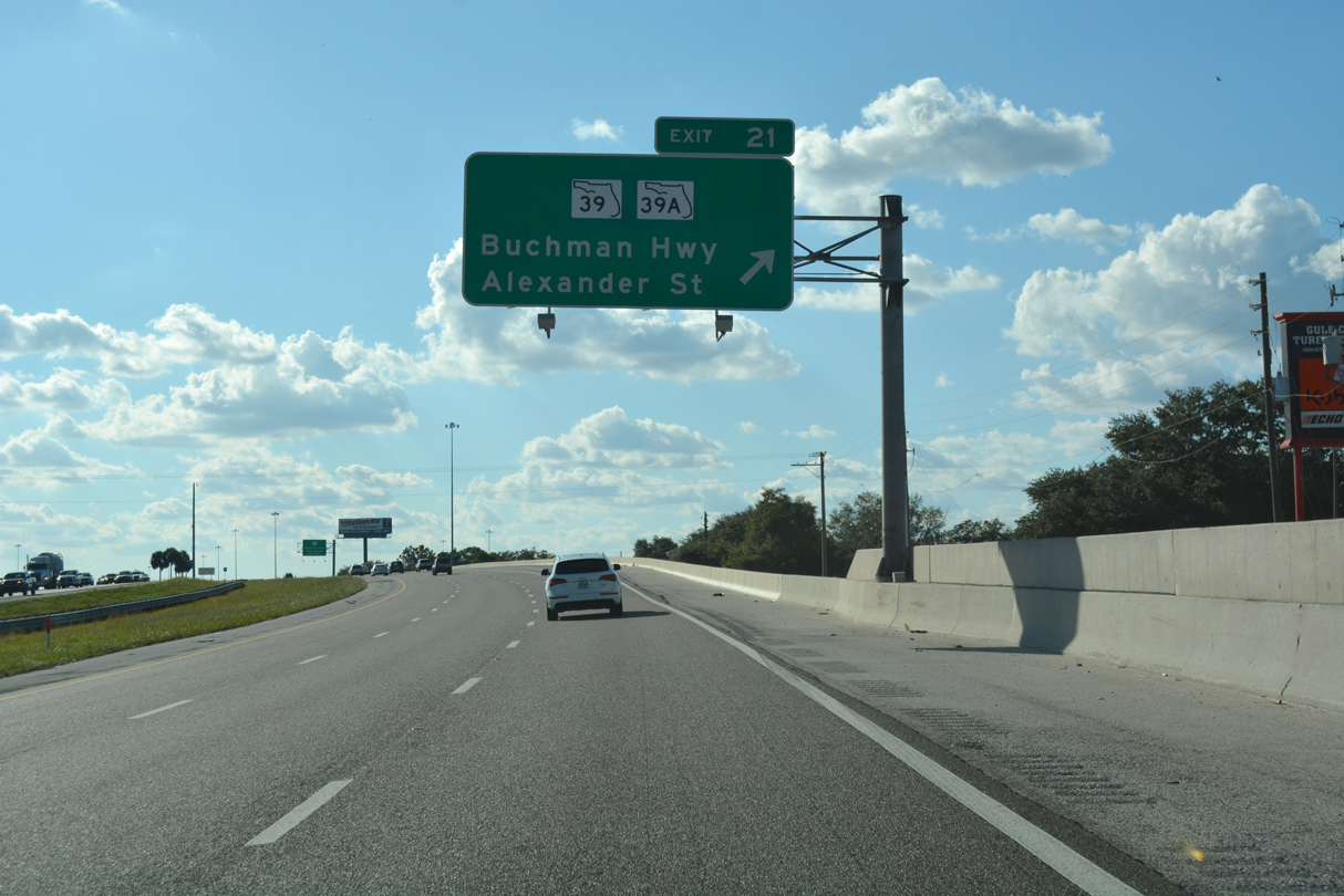
| A c/d roadway (Exit 21) leads to both SR 39A (Paul Buchman Highway / Wheeler Street) and SR 39 (Alexander Street). Alexander Street (formerly SR 39A) loops south from Franklin Street and I-4 to U.S. 92 and James L. Redman Parkway around the west side of Plant City. 11/04/17 |
|
| I-4 passes over N Frontage Road, a CSX Railroad and Wheeler Street (CR 39) beyond the separation with Exit 21. A folded diamond interchange follows with Wheeler Street south to Downtown and SR 39A (Paul Buchman Highway) north to Zephyrhills. 11/04/17 |
|
| A loop ramp departs the c/d roadway for Wheeler Street south and SR 39A north. SR 39 overtakes Paul S. Buchman Highway north 13 miles to U.S. 301 at the city of Zephyrhills. 11/04/17, 06/02/18 |
|
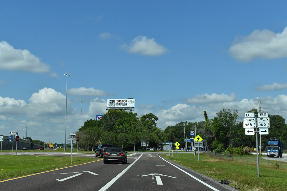
| SR 566 (Thonotosassa Road) spurs northwest from U.S. 92 (Baker Street) to a diamond interchange with I-4 at Exit 19. SR 39 (Alexander Street) intersects U.S. 92 (Baker Street west / Thonotosassa Road east) one mile to the south. 03/26/19 |
|
| The succeeding loop ramp departs for SR 39 (N Alexander Street) north to Zephyrhills and south along the western bypass of Plant City. Beyond Plant City, SR 39 travels south to SR 60 and CR 39 at Hopewell. 03/26/19 |
|
| A fourth westbound lane opens between the c/d roadway for SR 39 (Alexander Street) and Exit 19 to SR 566 (Thonotosassa Road) east and unsigned CR 582 west. 03/26/19 |
|
| SR 566 follows Thonotosassa Road 0.93 miles south from Exit 19 to U.S. 92 (Baker Street) by the Florida Strawberry Festival grounds. 03/26/19 |
|
| SR 566 ends on the north side of the exchange with I-4. Thonotosassa Road extends west as unsigned CR 582A local route to Cork Road and the intersection of Stafford and Forbes Roads. 09/20/17, 03/26/19 |
|
| Demolished by 2009, weigh stations were formerly located along both directions of Interstate 4 between Exits 19 and 14. 09/01/18 |
|
| Branch Forbes Road meets I-4 at the forthcoming diamond interchange (Exit 17). The rural road travels north 1.5 miles to CR 580 (Sam Allen Road / Thonotosassa Road). Thonotosassa Road resumes in name from Branch Forbes Road west to Antioch and the community of Thonotosassa. 05/30/19 |
|
| South from Exit 17, Branch Forbes Road continues 1.7 miles to SR 574 (Dr. Martin Luther King, Jr. Boulevard) east of Dover and 3.5 miles to Sydney Road at the community of Turkey Creek. 05/15/16 |
|
| The lone state named shield for Interstate 4 west precedes the Bethlehem Road overpass near Dover. 06/15/13 |
|
| The last in the series of distance signs for I-75 and I-275 along Interstate 4 west. 09/01/18 |
|
| McIntosh Road converges with Interstate 4 at a diamond interchange (Exit 14) in one mile. McIntosh Road heads north two miles to Antioch and six miles to U.S. 301 (Fort King Highway). 09/01/18 |
|
| New weigh stations were constructed between 2007 and 2009 to replace those used previously near Plant City. The facilities lie just west of Exit 14. 09/01/18 |
|
| McIntosh Road meets parallel U.S. 92 (Hillsborough Avenue) a half mile south of Exit 14, and SR 574 (Dr. Martin Luther King, Jr. Boulevard) within the vicinity of Seffner in 2.25 miles. 09/01/18 |
|
| Interstate 4 passes over McIntosh Road one mile ahead of the aforementioned weigh station. 05/15/16 |
|
| Bending more to the southwest, Interstate 4 crosses a canal as it bypasses Seffner. 05/15/16 |
|
| A replacement of the "Tampa - 13" distance sign made in May 2020 added Ybor City, a neighborhood within the city. 05/22/20 |
|
| Both weigh stations along I-4 lie east of Kingsway Road. Both were constructed as part of a $36.7 million project between June 2007 and November 2009.1 06/15/13 |
|
| A sparsely signed route, CR 579 follows Mango Road northward 3.5 miles from Exit 10 to Thonotosassa and 4.25 miles to U.S. 301 near Hillsborough River State Park. Despite being replaced in 2017, a new assembly for Exit 10 was erected in May 2020. 05/22/20 |
|
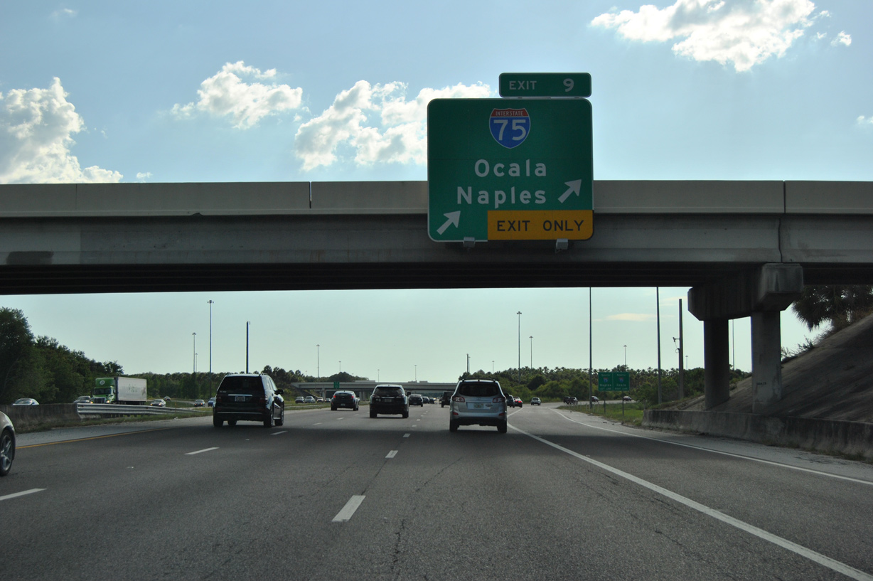
| Two miles out from the turbine interchange (Exit 9) with Interstate 75 near Mango. 05/22/20 |
|
| CR 579 (Mango Road) meets U.S. 92 (Hillsborough Avenue) just south of the diamond interchange at Exit 10 and SR 574 (MLK Boulevard) in unincorporated Mango. 09/01/18 |
|
| I-4 advances one mile from Mango Road to Interstate 75. I-75 constitutes a commuter route north to Temple Terrace, New Tampa and Wesley Chapel and south to Brandon, Riverview and Ruskin. 09/01/18 |
|
| Interstate 4 passes between an area of wetlands ahead of the exchange with I-75. 09/01/18 |
|
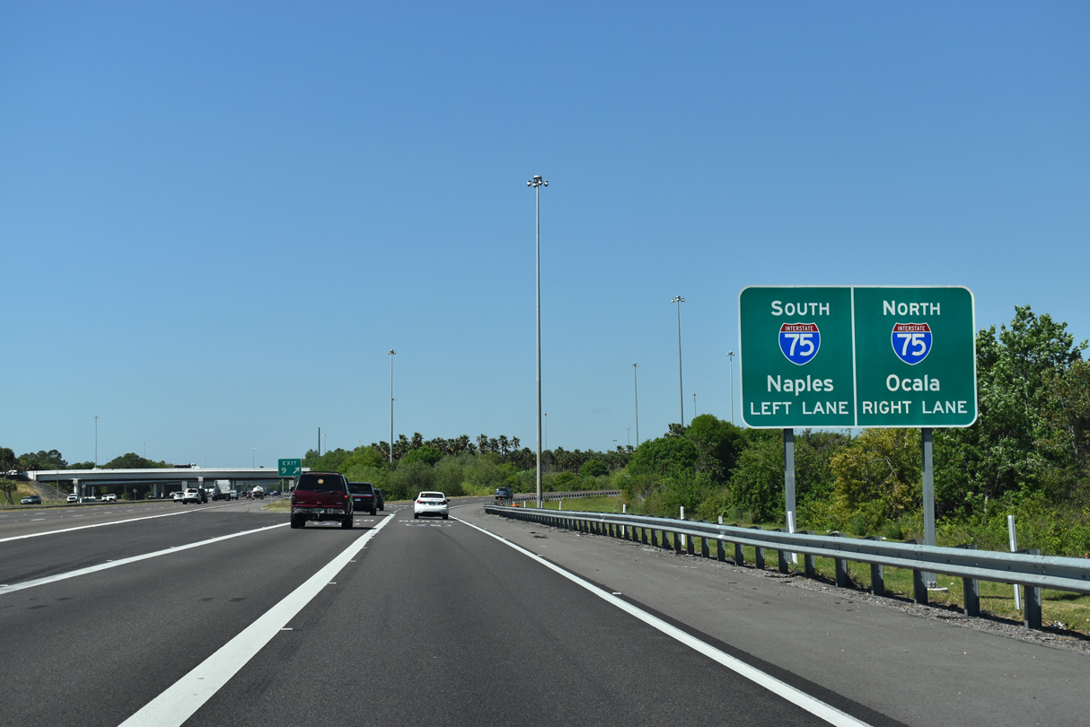
| Generally bypassing Tampa to the east, Interstate 75 serves regional traffic between Southwest Florida and Gainesville. 05/15/16 |
|
| Ybor City was retained on the distance sign replacement preceding I-75. Located south of I-4 and northeast of Downtown Tampa, Historic Ybor City was annexed by Tampa in 1887. 05/22/20 |
|
| Exit 9 separates from I-4 west with two lanes below Williams Road. Heading north from Tampa, I-75 stays inland to Ocala and Lake City en route to Atlanta, Georgia. 05/15/16 |
|
| Traveling 479 miles in the Sunshine State, I-75 originates at Hialeah in South Florida and departs for Georgia near Jennings. South from Tampa Bay, I-75 joins Bradenton, Sarasota, Fort Myers and Naples in Southwest Florida. 03/17/21 |
|
| The succeeding two exits from I-75 north serve the city of Temple Terrace. Unincorporated Brandon spreads east of I-75, four miles south of I-4. 03/17/21 |
|
| I-75 ventures 88 miles north to Ocala, 122 miles to Gainesville and 450 miles to Atlanta. I-75 south heads 125 miles to the Fort Myers area, 155 miles to Naples and 278 miles to Miami (via SR 826 and SR 836). 03/17/21 |
06/15/13, 05/15/16, 09/20/17, 11/04/17, 06/02/18, 09/01/18, 03/26/19, 05/30/19, 05/22/20, 03/17/21 by AARoads
Page Updated 09-21-2022.

 West
West