|
| County Route 44 (N Main Street) branches southwest from US Hwy 50 to the Shiloh village center. The route spans I-64/U.S. 50 by this shield assembly. 04/05/13 |
|
| I-64/U.S. 50 west straddle the O'Fallon and Shiloh line west to Green Mount Road. This distance sign predates the opening of Exit 16 to Green Mount Road. 04/05/13 |
|
| A commercialized diamond interchange (Exit 16) joins I-64/U.S. 50 with Green Mount Road in one mile. 04/05/13 |
|
| Green Mount Road constitutes an arterial route north to US Hwy 50 in O'Fallon and south to parallel CR 95 (Frank Scott Parkway) through a retail area anchored by Green Mount Crossing shopping center. 04/05/13 |
|
| Exit 16 open up adjacent areas for development in the late 1990s. Green Mount Road otherwise heads south as a growing suburban route to Belleville and County Road 4 (Old Freeburg Road) and north to a roundabout with State Street and Obernuefemann Road north to O'Fallon Sports Park. 04/05/13 |
|
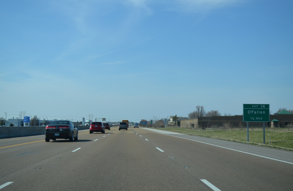
| Turning northwest, I-64/U.S. 50 converges with US Hwy 50 at a diamond interchange (Exit 14) in one mile. 04/05/13 |
|
| Commercial frontage roads (Central Park Drive to the west and Regency Park to the east) line I-64/U.S. 50 north to Exit 14 as the freeway expands to six overall lanes. 04/05/13 |
|
| US Hwy 50 expands into a four lane divided commercial arterial west from State Street to Long Drive across I-64/U.S. 50. 04/05/13 |
|
| Exit 14 leaves I-64/U.S. 50 west for US Hwy 50. Old U.S. 50 continues west from O'Fallon into Fairview Heights, becoming Lincoln Trail west from IL 159. 04/05/13 |
|
| I-64/U.S. 50 bend back to the west by Lincoln Crossing shopping center. A north side frontage road parallels the freeway to IL 159. 04/05/13 |
|
| IL 159, a 62 mile long highway north from IL 3 at Red Bud to IL 138 outside Bunker Hill, connects with I-64/U.S. 50 at a six-ramp parclo interchange (Exit 12) in one mile. 04/05/13 |
|
| I-64/U.S. 50 west enter the city of Fairview Heights beyond the Old Collinsville Road overpass. IL 159 runs south from the city into the adjacent village of Swansea on Illinois Street. 04/05/13 |
|
| IL 159 leads south from Swansea to Belleville, seat of St. Clair County. A portion of the route between adjacent Lincoln Trail (old U.S. 50) and IL 161 in south Swansea, represents former U.S. 50 Bypass. Old U.S. 50 remains westward through Fairview Heights onto St. Clair Avenue and IL 161 ahead of IL 157. 04/05/13 |
|
| St. Clair Square mall anchors the adjacent retail area spreading south along IL 159 from the parallel CSX Railroad to Longacre Drive. North of the CSX Railroad, IL 159 transitions into a semi-rural route to Oak Hills and the city of Collinsville. 04/05/13 |
|
| I-64/U.S. 50 traverse a series of forested hills to the Caseyville village line. 04/05/13 |
|
| 12 miles of I-64 remain leading to Downtown St. Louis from Fairview Heights. 04/05/13 |
|
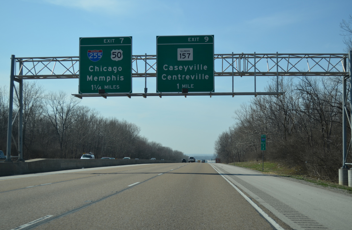
| Interstate 255 and I-64 come together at a cloverleaf interchange (Exit 7) in two miles. U.S. 50 partitions from I-64 west to accompany I-255 south to Columbia, the Jefferson Barracks Bridge and Mehlville, Missouri. 04/05/13 |
|
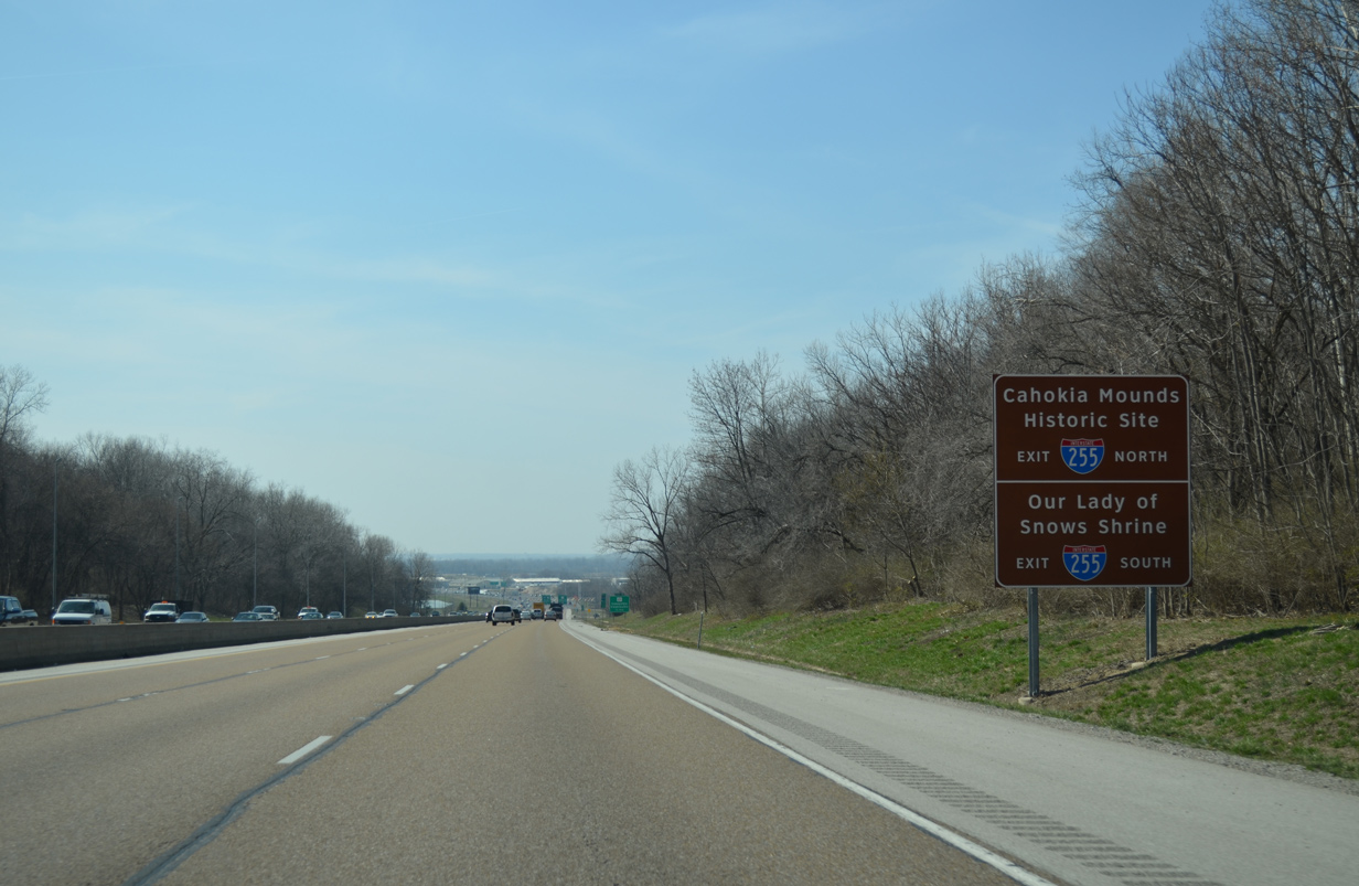
| Forthcoming I-255 north to Collinsville provides the fastest route to Cahokia Mounds Historic Site via Exit 24. Our Lady of Snows Shrine lies east of Exit 17 A / IL 15 via I-255 south in Belleville. 04/05/13 |
|
| I-64/U.S. 50 west lower onto the American Bottoms area spreading east from the Mississippi River. The folded diamond interchange (Exit 9) with IL 157 lies opposite the bluffs southwest of the Caseyville village center and northeast of Edgemont in East St. Louis. 04/05/13 |
|
| Exit 9 departs I-64/U.S. 50 west for IL 157 southwest to Centreville and northeast to Caseyville and Collinsville. One half mile remains before U.S. 50 separates with I-64 west via a collector distributor roadway for the St. Louis beltway (I-255). 04/05/13 |
|
| Two lanes branch away from I-64 west for the c/d roadway at Exit 7. Interstate 255 provides a long distance bypass for I-55 between Springfield and Cape Girardeau, Missouri. The beltway uses Chicago and Memphis as control cities for the regional destinations along I-55. 04/05/13 |
|
| Interstate 255 angles northeast through Caseyville to Collinsville and I-55/70. I-255 ends in ten miles at I-270 near Edwardsville, with IL 255 extending north as a freeway spur to Alton and Godfrey. 04/05/13 |
|
| Exit 7 A loops onto a c/d roadway along I-255/U.S. 50 west to Alorton, Centreville, Cahokia and Columbia. I-255 south becomes I-270 north at Mehlville, Missouri, where U.S. 50 joins Lindbergh Boulevard (U.S. 61/67) north to Sunset Hills and I-44 west. 04/05/13 |
|
| Interstate 64 enters the village of Washington Park beyond the Alton & Southern Railway underpass to next meet IL 111 (Kingshighway). The subsequent exits lie within the city of East St. Louis. 12/31/23 |
|
| The ending c/d roadway from I-255 forms an auxiliary lane to Exit 6 with IL 111 (Kingshighway). 12/31/23 |
|
| A six-ramp parclo interchange (Exit 6) links I-64 with IL 111 (Kingshighway) in a quarter mile. 12/31/23 |
|
| IL 111 begins at North 59th Street and Lake Drive by Frank Holten State Park in the city of Centreville. 59th Street becomes Kingshighway north through East St. Louis to the Washington Park village center. 12/31/23 |
|
| Westbound I-64 at Exit 6 to IL 111 (Kingshighway) in Washington Park. Overall IL 111 runs 78 miles north from Centreville to Fairmont Cit, Pontoon Beach, Wood River and ultimately Waverly. 12/31/23 |
|
| The remaining stretch of I-64 west to I-55 is the Wyvetter Younge Memorial Parkway. Younge was the area member of the Illinois House of Representatives from 1975 to her death in 2008.1 12/31/23 |
|
| Interstate 64 crosses the East St. Louis city line at the N 38th Street underpass. 12/31/23 |
|
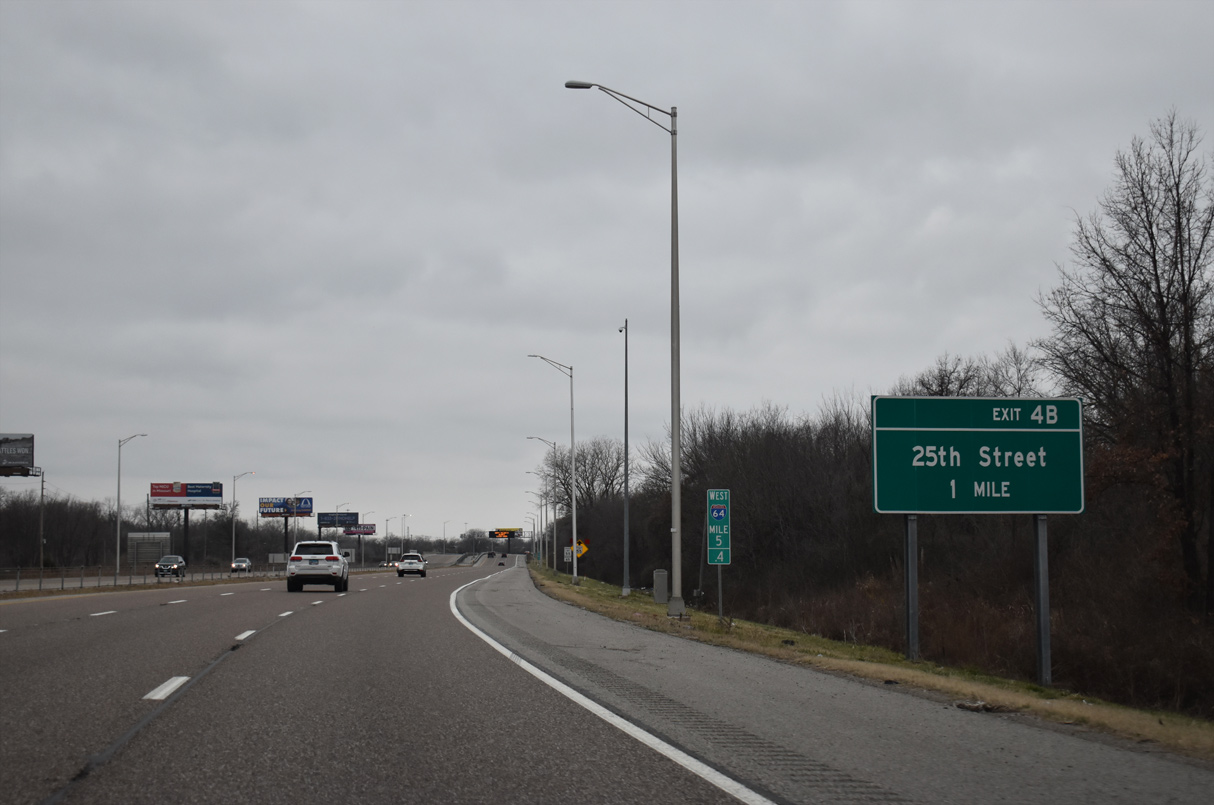
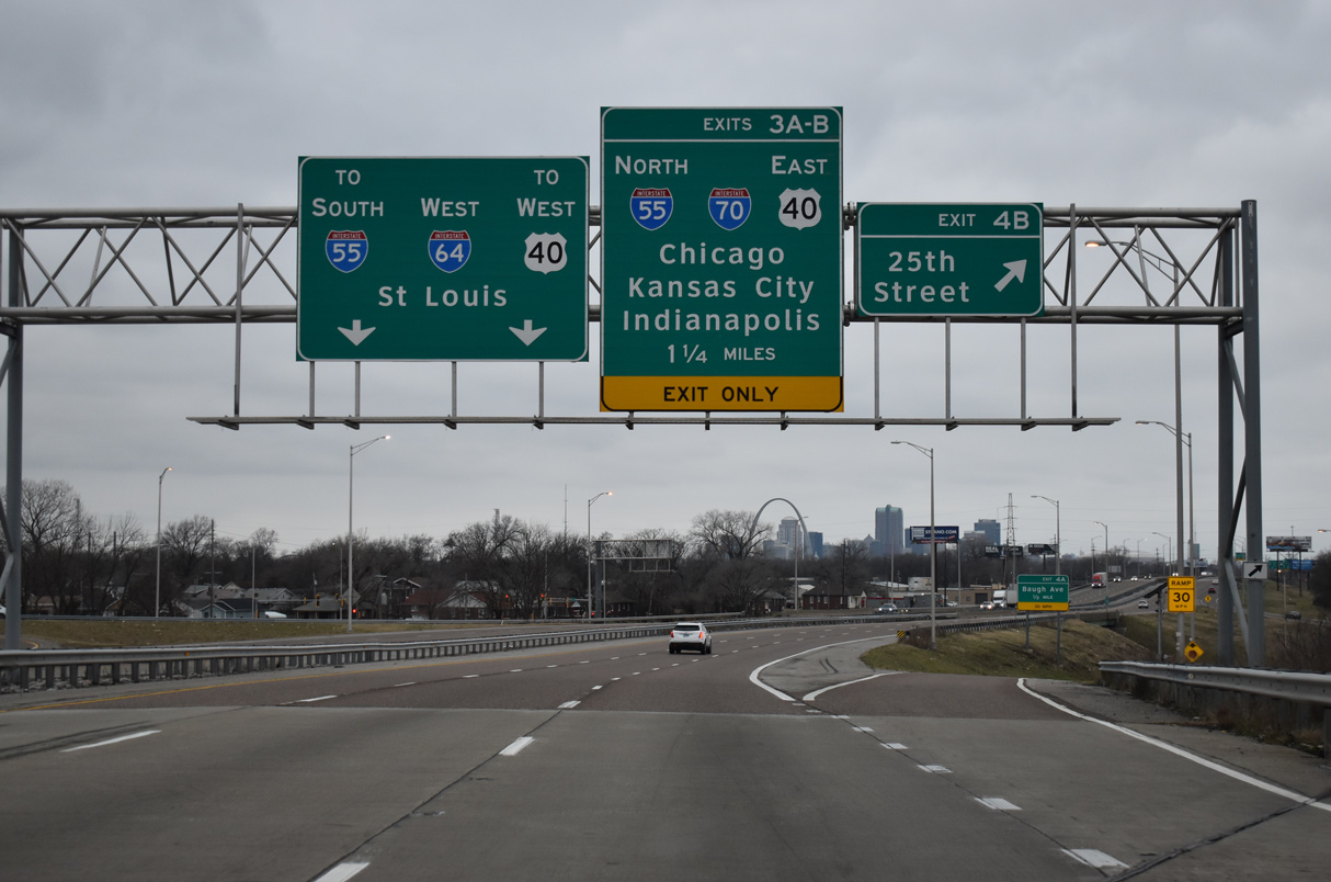
| A parclo interchange (Exit 4 B) joins Interstate 64 with 25th Street at St. Clair Avenue (old U.S. 50) in one mile. 12/31/23 |
|
| Upcoming Exit 4B serves the Metrolink JJK Center Station by the Jackie Joyner-Kersee Center and Jones Park to the north of Interstate 64. 25th Street north becomes 26th Street and Caseyville Avenue east into Washington Park. 12/31/23 |
|
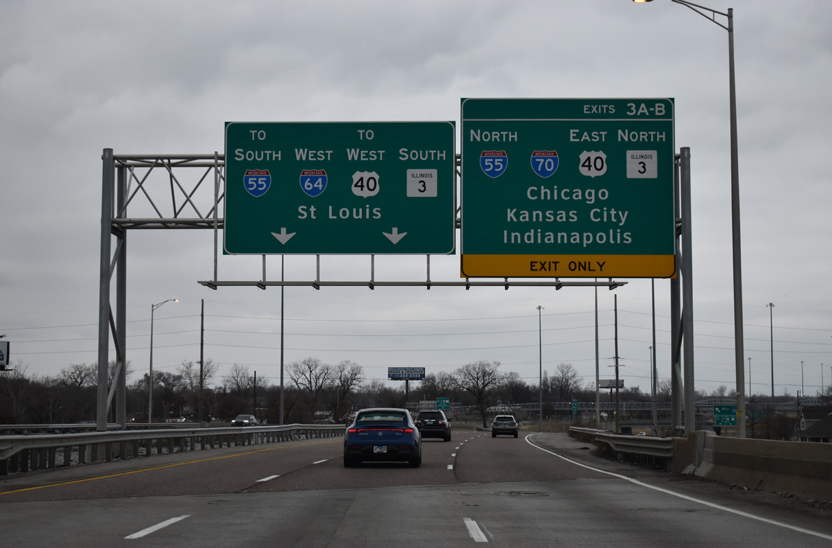
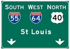
| I-64 combines with I-55/U.S. 40 west at a systems interchange (Exit 3) connecting with Interstate 70. I-70 was realigned in 2014 to bypass Downtown St. Louis to the north along the Stan Musial Veterans Memorial Bridge. 12/31/23 |
|
| Exit 4 A connects I-64 westbound with a roundabout joining Baugh Avenue with N 18th Street in East St. Louis. 12/31/23 |
|
| Baugh Avenue originally split from parallel St. Clair Avenue (old U.S. 50) to pass under I-64. That section was subsequently abandoned as part of the reconstruction of I-64 associated with the realignment of I-70. 12/31/23 |
|
| Interstate 64 spans TRRA and Norfolk Southern Railroad lines ahead of Exit 4 A. Baugh Avenue parallels I-64 northwest to a roundabout with N 9th Street and an entrance ramp to I-55/70 north. 12/31/23 |
|
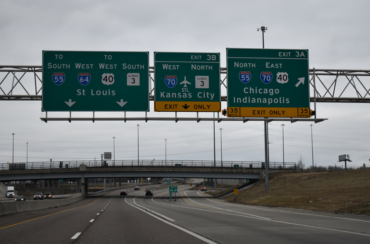
| Exits 3 A for I-55/70-U.S. 40 east to Collinsville and Troy and 3 B for I-70 west across the Stan Musial Veterans Memorial Bridge and IL 3 north to Brooklyn depart from westbound I-64 simultaneously in a half mile. 12/31/23 |
|
| I-70 west was relocated off the Poplar Street Bridge alongside I-55/64 on February 4, 2014, when the Stan Musial Veterans Memorial Bridge spanning the Mississippi River opened to traffic. 12/31/23 |
|
| A new pedestrian bridge was built in 2011 over Interstate 64 for the nearby Emerson Park Metrolink Station. 12/31/23 |
|
| Traffic separates at the 9th Street overpass into ramps for I-55/64 west to the Poplar Street Bridge and Downtown St. Louis, I-70 west through north St. Louis and I-55/70 east to Chicago and Indianapolis respectively. 12/31/23 |
|
| Exit 3 A joins I-55/70 north ahead of Exit 4 for IL 203 to Madison and Fairmont City. 12/31/23 |
|
| The eastbound mainline for I-70 spans I-64 westbound on a flyover ramp. The original exchange joining I-64 with I-55/70 was the Tri-Level Interchange. 12/31/23 |
|
| Interstate 64 combines with I-55/U.S. 40 west ahead of Left Exit 2 B to the Dr. Martin Luther King, Jr. Memorial Bridge. The MLK bridge connects East St. Louis with Downtown St. Louis. 12/31/23 |
|
| Left Exit 2 A departs in 0.75 miles from within the wye interchange (Exit 2 B) for the Martin Luther King, Jr. Memorial Bridge. Exit 2 A connects with N 3rd Street west to Riverpark Drive for the Eads Bridge across the Mississippi River. 12/31/23 |
Page Updated 01-07-2024.


 West
West