|
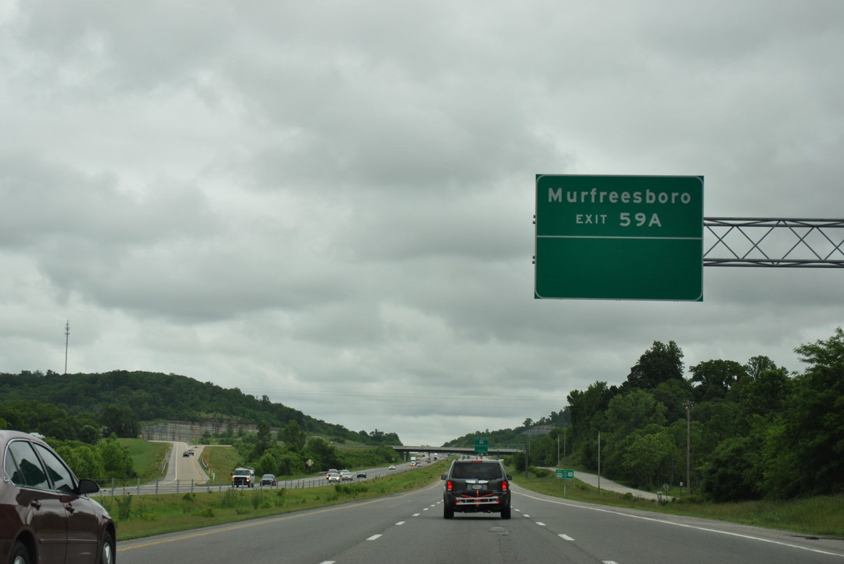
| U.S. 431 (Lewisburg Pike) and the West Harpeth River pass underneath I-65 one mile ahead of Exits 59 A/B to Interstate 840. 11/04/09 |
|
| Interstate 840 comprises a 78 mile long outer beltway around Nashville, from I-40 at Exit 176 near Dickson to I-40 at Exit 235 in Wilson County. 05/27/11 |
|
| I-840 leads 22 miles east from I-65 to I-24 in northwest Murfreesboro. I-840 west from Exit 28 / U.S. 31 to Exit 14 / SR 46 was completed in 2012. The segment north from Exit 14 to Exit 7 / SR 100 opened to traffic on October 27, 2010. 05/27/11 |
|
| Interstate 840 spurs west three miles from Exit 59 B to U.S. 431 (Lewisburg Pike) and U.S. 31 (Columbia Pike) near Thompson's Station. This stretch of roadway opened in October 2001. 05/27/11 |
|
| I-840 northwest connects with I-40 near Dickson in 31 miles. Beyond Mufreesboro, I-840 heads north to I-40 at Lebanon, 45.7 miles from Exit 59. 05/27/11 |
|
| The distributor roadway for Exit 59 separates to I-840 east for Murfreesboro and I-840 west between Spring Hill and Franklin. A cloverstack interchange joins I-65/840. 05/27/11 |
|
| 2015/16 construction expanded Interstate 65 from six to eight lanes northward from I-840. 06/11/17 |
|
| The left lane is restricted to HOV-2 traffic during weekday mornings along Interstate 65 northbound beyond Lookout Hill southeast of Franklin. 06/11/17 |
|
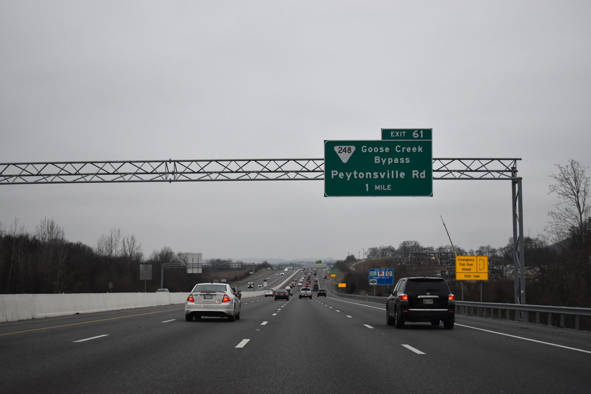
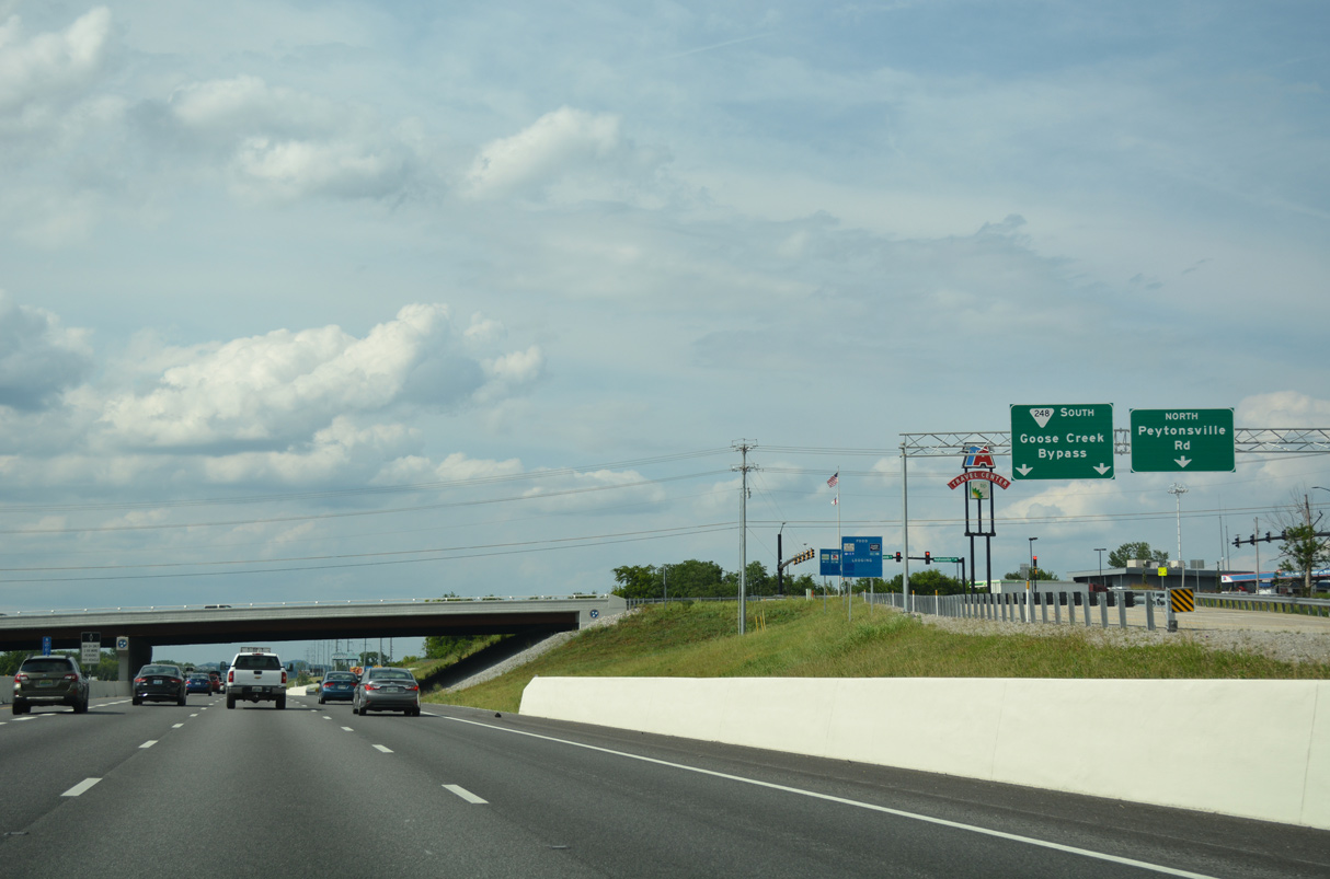
| The first of five exits from I-65 north for the city of Franklin links with SR 248 (Goose Creek Bypass) and Peytonsville Road. 01/15/19 |
|
| SR 248 (Goose Creek Bypass) arcs 3.66 miles southwest from I-65 at Exit 61 to U.S. 31 (Columbia Pike) near the Thompson's Station town line. 01/15/19 |
|
| Peytonsville Road turns southward beyond the diamond interchange at Exit 61 to Peytonsville and I-840 at Exit 34. 01/15/19 |
|
| SR 266 west to U.S. 431 (Lewisburg Pike) leads to Douglas and Ellington Park in Franklin. Williamson County AG Expo Park lies just northeast of Exit 61. 06/11/17 |
|
| Pier supports for an unbuilt overpass north of Exit 61. 06/11/17 |
|
| TDOT recorded 107,280 vehicles per day along I-65 between Exits 61 and 65 in 2017. 01/15/19 |
|
| Interstate 65 continues north to a commercialized diamond interchange (Exit 65) with SR 96 (Murfreesboro Road) in east Franklin. 01/15/19 |
|
| Interstate 65 was expanded from six to eight lanes north between Exits 61 and 65 in 2011/12. 06/11/17 |
|
| I-65 advances a half mile north to Exit 65 and SR 96 (Murfreesboro Road). The state route leads west to the Franklin city center and eastward to Arrington and Truine. The exit serves interests to Carter House State Historic Site and the Historic Carnton Plantation. 06/11/17 |
|
| SR 96 is not the fastest way between Franklin and Murfreesboro, but it is the most direct. Overall the state route travels 126.7 miles from U.S. 70 at Dickson and SR 53 at Granville.1 01/15/19 |
|
| The last three exits along Interstate 65 north in Franklin are heavily commercialized. 06/11/17 |
|
| An additional 30,000 vehicles per day join Interstate 65 north from SR 96 (Mufreesboro Road). 06/11/17 |
|
| Northbound I-65 passes over Liberty Pike on the half mile preceding the single point urban interchange (Exit 67) with McEwen Drive. 06/11/17 |
|
| McEwen Drive stretches 3.9 miles east across Franklin from Cool Springs Boulevard to SR 252 (Wilson Pike) 06/11/17 |
|
| Improving access to the Cool Springs area of Franklin, Exit 67 opened to traffic on September 14, 2007. Costing $29.9 million, construction on the SPUI commenced in late 2005.2 06/11/17 |
|
| Interstate 65 crosses the South Prong of Spencer Creek beyond this confirming marker. 06/11/17 |
|
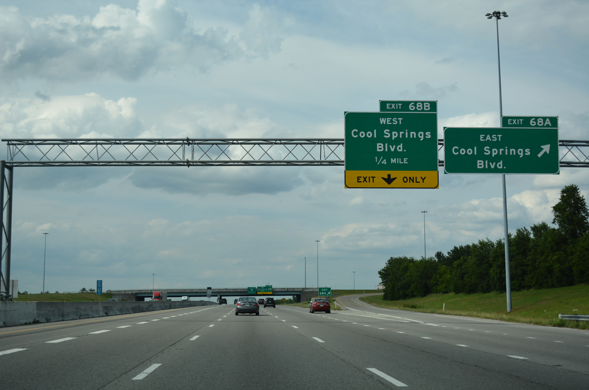
| A six-ramp parclo interchange (Exit 68 joins Interstate 65 with Cool Springs Boulevard amid a cluster of office parks. 06/11/17 |
|
| Exit 68 A leaves Interstate 65 north for Cool Springs Boulevard east to commercial areas west of Seward Hills and residential areas south to Oxford Glen Drive. 06/11/17 |
|
| Cool Springs Boulevard weaves 1.6 miles southwest from Exit 68 B through an area of retail and offices to SR 397 (Mack Hatcher Memorial Parkway) at Ropers Knob. 06/11/17 |
|
| Interstate 65 passes by additional office parks and Coolsprings Galleria mall north to Exit 69 with SR 441 (Moores Lane). 06/11/17 |
|
| Bakers Bridge Avenue passes over Interstate 65 at Exit 69. SR 441 (Moores Lane) links I-65 with U.S. 31 (Franklin Road) 1.55 miles to the west and with SR 252 (Wilson Pike) 2.13 miles to the east. 06/11/17 |
|
| SR 441 (Moores Lane) comprises a commercial arterial at the six-ramp parclo interchange (Exit 69) with I-65. The arterial continues into residential areas beyond the freeway corridor. 06/11/17 |
|
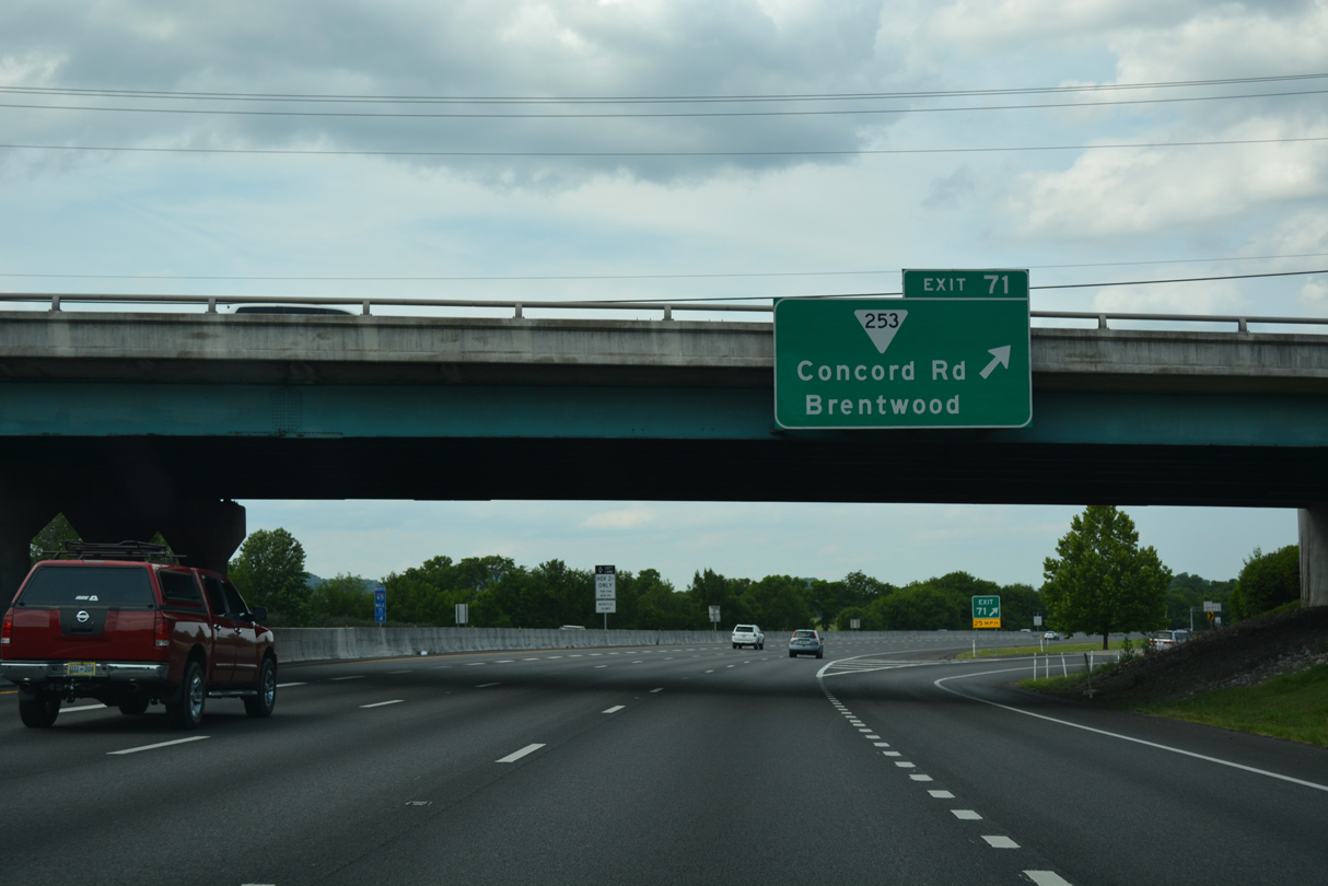
| Interstate 65 proceeds north into the city of Brentwood ahead of Exit 71 with SR 253 (Concord Road). 06/11/17 |
|
| The folded diamond interchange at Exit 71 connects I-65 with SR 253 (Concord Road) at Lipscomb Drive south. Lipscomb Drive and General MacArthur Drive to the west are residential streets paralleling I-65 southward. 06/11/17 |
|
| Measuring 7.24 miles in length almost wholly within Brentwood, SR 253 (Concord Road) runs west to U.S. 31 (Franklin Road) nearby. East from Exit 71, SR 253 continues to U.S. 31A/41A (Nolensville Pike) just across the Nashville / Davidson County line. 06/11/17 |
|
| Interstate 65 crosses the Little Harpeth River beyond this reassurance shield posted ahead of milepost 72. 06/11/17 |
|
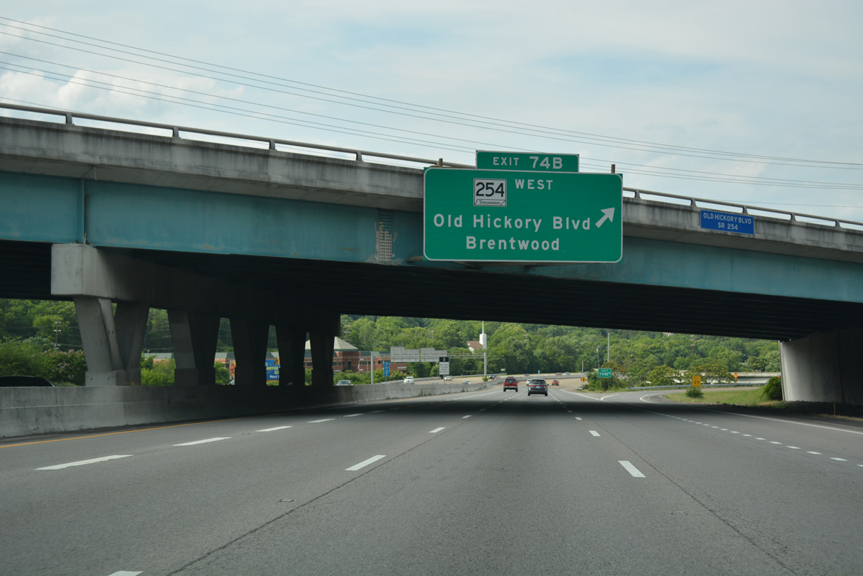
| SR 254 (Old Hickory Boulevard) straddles the Davidson / Williamson County line west from Exits 74 A/B to SR 100 at Edwin Warner Park. 06/11/17 |
|
| SR 254 (Old Hickory Boulevard)continues east from the six-ramp parclo interchange at Exit 74 to Holt Knob, Antioch and Interstate 24 at Exit 59. 06/11/17 |
|
| SR 254 travels 17.29 miles across southern areas of Nashville, extending east to U.S. 41/70S (Murfreesboro Pike) in the Rural Hill area. 06/11/17 |
|
| I-65 enters Nashville and Davidson County just ahead of Exit 74 B for SR 254 (Old Hickory Boulevard) west to U.S. 31 (Franklin Road) and Granny White Pike south back into Brentwood. 06/11/17 |
Page Updated 12-15-2023.

 North
North