|
| The diamond interchange at Exit 142 is the first of three exchanges along I-65 within Lowndes County. 04/13/12 |
|
| SR 185 intersects Interstate 65 on its return to U.S. 31 to the east at Exit 142. Fort Deposit is the main town of consequence along SR 185 on this stretch. The community can be found two miles to the west. 04/13/12 |
|
| Traffic to SR 185 (Old Fort Road) departs Interstate 65 north at Exit 142. The state route concludes at U.S. 31 and the settlement of Logan. 04/13/12 |
|
| Northbound distance sign and shield posted 11 miles out from Letohatchee and 30 miles south of Montgomery. 04/13/12 |
|
| Curving under Bishop Bottom Road and over Big Swamp Creek along the forested stretch of Interstate 65 north toward Letohatchee. 04/13/12 |
|
| Approaching the bridge over Cherry Creek. Allentown Road passes over the freeway in the far distance. 04/13/12 |
|
| SR 97 travels north-south 29.80 miles between U.S. 331 and U.S. 80 in central Alabama. The state highway intersects Interstate 65 at a diamond interchange (Exit 151) near the community of Letohatchee. 04/13/12 |
|
| Interstate 65 north, one half mile ahead of Exit 151 to SR 97. The state route leads 4.2 miles southeast to U.S. 31, which it overlaps with east to the community of Davenport. 04/13/12 |
|
| North from Exit 151, SR 97 leads to SR 21 at Hayneville and U.S. 80 at Lowndesboro. 04/13/12 |
|
| Much of the freeway between SR 97 and Tyson includes a roadway split with a forested median. 04/13/12 |
|
| Located southwest of the Montgomery County, the diamond interchange at Exit 158 connects with Lowndes County Route 6 (Tyson Road). CR 6 connects with CR 26 west to Tyson and the county seat of Hayneville. 04/13/12 |
|
| Lowndes County Route 6 (Tyson Road) becomes Montgomery County Route 24 (Cloverfield Road) nearby. CR 24 crosses the Pinchony Creek at Federal Road ahead of U.S. 31 at Pintlalla. 04/13/12 |
|
| Pintlalla and U.S. 31 lie 3.5 miles to the east of Exit 158. The community of Tyson lies just under two miles to the west. 04/13/12 |
|
| Continuing northeastward, Interstate 65 travels six miles to Hope Hull in south Montgomery County. 06/21/05, 04/13/12 |
|
| Crossing the Montgomery County line on Interstate 65 north, 18.74 miles after entering Lowndes County. 04/13/12 |
|
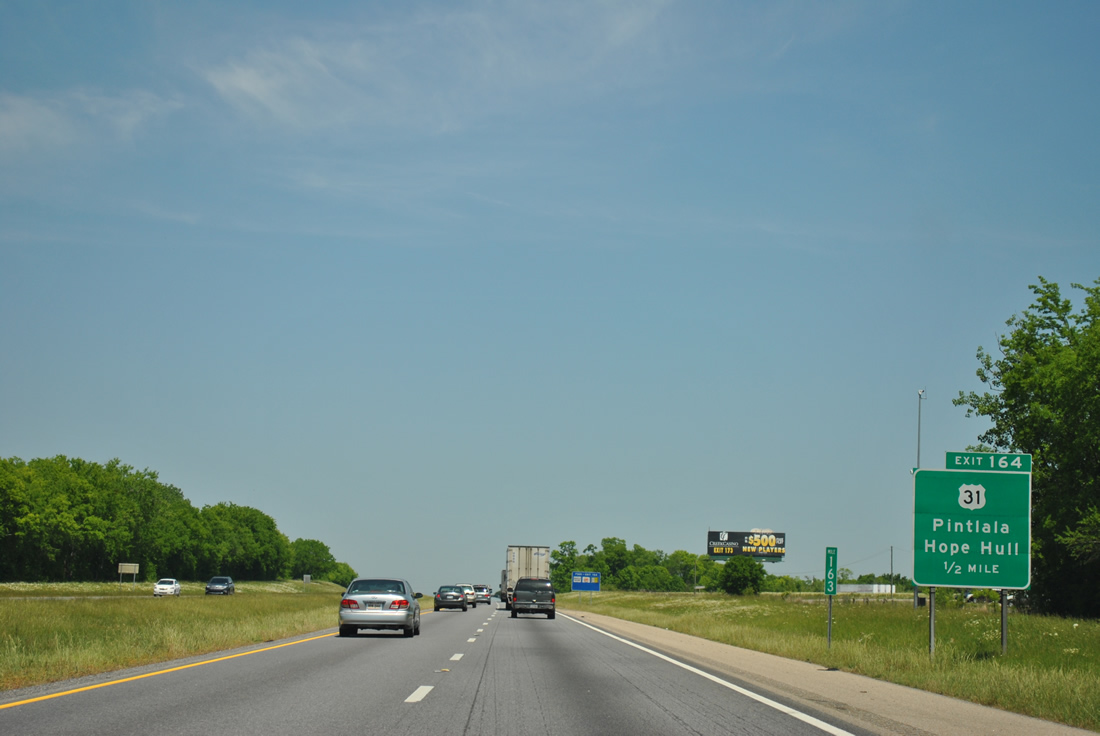
| Although U.S. 31 mirrors the course of Interstate 65 from Perdido northward, Exit 164 represents the first direct meeting between the two. This is also the first exit within the Montgomery metropolitan area. 10/06/12 |
|
| Montgomery County Route 42 (Hyundai Boulevard / former Teague Road) comprises a 3.5 mile connection to parallel U.S. 331 (Norman Bridge Road) and the Hyundai manufacturing plant opened on May 20, 2005. Construction of the plant resulted in a widening of U.S. 31, CR 42 and U.S. 331. 10/06/12 |
|
| One half mile south of the diamond interchange (Exit 164) with U.S. 31 (Mobile Highway) and the community of Hope Hull on Interstate 65 north. Hope Hull mainly consists of industrial and mobile home parks. 04/13/12 |
|
| Interstate 65 northbound at Exit 164 to U.S. 31 (Mobile Highway). The planned Montgomery bypass is proposed to meet I-65 at milepost 163. Since first appearing on maps in the 1990s, the bypass was eventually included in a proposal to extend I-85 westward to Selma and Cuba. 04/13/12 |
|
| U.S. 31 shield assembly posted at the end of the Exit 164 off-ramp. An industrial park and a truck stop lie nearby with U.S. 31 carrying five overall lanes. 04/13/12 |
|
| Travelers enter the Montgomery city limits north of the Hyundai Boulevard overpass ahead of six interchanges for the capital city. Downtown remains eight miles away. 04/13/12 |
|
| One mile south of the U.S. 80 eastbound merge onto Interstate 65 northbound at Exit 167. U.S. 80 enters Interstate 65 from a one mile freeway spur connecting with U.S. 31 to the west. The freeway was constructed in 1992 and shifted U.S. 80 from a shared alignment with Mobile Highway northward to South Boulevard onto the freeway.
Note that the sign was replaced between 2003 and 2005. Both panels are damaged! 08/22/03, 11/03/11 |
|
| U.S. 80 is a part of the Selma to Montgomery National Historic Trail. The four lane divided highway travels 65 miles west to the city of Selma while passing by Dannelly Field / Montgomery Regional Airport (MGM) in three miles. The speed limit drops from 70 to 60 mph ahead of Exit 167. The reduction was only to 65 in 2005. 04/13/12 |
|
| I-65 enters a directional interchange with U.S. 80 (Selma Highway) north of Southlawn Drive. U.S. 80 is a part of High Priority Corridor 6, a designation that extends westward to I-59/20 near Meridian, Mississippi. The planned Montgomery Bypass (SR 108) will join U.S. 80 west of the airport. 01/16/04 |
|
| Another look at the Exit 167 sign bridge. Included is the one mile overhead, and its 2010 replacement, for Exit 168, the U.S. 80 eastbound departure onto South Boulevard. U.S. 82 will enter onto Interstate 65 northbound from South Boulevard for a 10.75 mile overlap to Exit 179. This relocation occurred in 2000 after a new U.S. 82 alignment opened between Prattville and the freeway in 1997. 08/22/03, 11/03/11 |
|
| Interstate 65 crosses Catoma Creek on the half mile approach to Exit 168 with South Boulevard. U.S. 80 departs for South Boulevard, joining U.S. 82 eastward to Troy Highway (U.S. 231). The north end of U.S. 331 (Court Street) exists two miles to the east. U.S. 231 joins U.S. 80 from Troy Highway northward along Eastern Boulevard.
Differences in Exit 168 signage over the years included "TO U.S. 31" in the 1990s, "TO U.S. 231 and 331" in the 2000s, and all three US route connections by 2010. The original button copy sign was replaced by 1999. Signage replacements occurred again in 2010 to coincide with widening of Interstate 65 through Montgomery. 04/18/95, 01/16/04 |
|
| Interstate 65 crosses the Catoma Creek on the half mile approach to Exit 168 with South Boulevard. U.S. 80 departs for South Boulevard, joining U.S. 82 eastward to Troy Highway (U.S. 231). The north end of U.S. 331 (Court Street) exists two miles to the east. U.S. 231 joins U.S. 80 from Troy Highway northward along Eastern Boulevard.
Differences in Exit 168 signage over the years included "TO U.S. 31" in the 1990s, "TO U.S. 231 and 331" in the 2000s, and all three US route connections by 2010. The original button copy sign was replaced by 1999. Signage replacements occurred again in 2010 to coincide with widening of Interstate 65 through Montgomery. 11/03/11 |
|
| South Boulevard was originally intended to circumvent traffic away from Downtown Montgomery in conjunction with East and North Boulevards. However without access control, commercial development ensued. A diamond interchange joins I-65 with the arterial that doubles as SR 21 from U.S. 31 (Mobile Highway) east to U.S. 231 (Wetumpka Highway). 01/16/04 |
|
| A $110 million project widening I-65 to six lanes between Exits 168 and 173 between 2006 and December 21, 2010.1 Extra capacity also increased the speed limit from 50 to 60 mph.
South Boulevard becomes West Boulevard at the nearby intersection of SR 21 and U.S. 31 (Mobile Highway). U.S. 31 stays west of the city core and Maxwell Air Force Base via Birmingham Highway (former U.S. 82). 04/13/12 |
|
| A look at the original four lane configuration of I-65, two miles south of the multi level interchange with I-85 north. 06/21/05 |
|
| Exit 170 follows on I-65/U.S. 82 north to Fairview Avenue (Exit 170) in one mile. 04/13/12 |
|
| A new overhead assembly was added for Interstate 85 north (Exit 171) to coincide with the expanded freeway. A barrier median replaced the original grassy one and Gateway Park Golf Course now occupies former wetlands to the east of Interstate 65. 01/19/13 |
|
| A diamond interchange joins I-65/U.S. 82 at Exit 170. 06/21/05, 04/13/12 |
|
| Traffic from Edgemont Avenue west and Oak Street north merges onto Interstate 65 north from a half diamond interchange (Exit 169 of I-65 south), one half mile out from Fairview Avenue. Fairview Avenue represents the original alignment of U.S. 80 from Mobile Highway. The road later (1974) was designated U.S. 80 Alternate to the one way couplet of Perry / Hull Streets (former Alternate U.S. 231 and U.S. 331). 04/13/12, 06/21/05 |
|
| The auxiliary lane from the Exit 169 on-ramp departs for Exit 170 / Fairview Avenue. Fairview Avenue remained within the state highway system as SR 21 to Norman Bridge Road (historic U.S. 331) until 1985. 01/16/04 |
|
| Exit 170 departs I-65 north for Fairview Avenue, one mile ahead of Interstate 85. Fairview Avenue leads east to Huntingdon College and Narrow Lane Road. 04/13/12 |
|
| The original sign bridge posted one mile south of Exit 171. Button copy signs were replaced by 1999.
Birmingham makes its debut as the Interstate 65 northbound control city. Alabama's largest city is situated 90 miles to the north of this junction. Meanwhile a major partition of traffic occurs at the split of Interstate 85 northbound. 162 miles to the northeast lies the central business district of Atlanta, Georgia. 01/16/04, 06/05/96 |
|
| Interstate 65 reduces to two northbound through lanes briefly through the Exit 171 stack interchange. A two lane ramp carries drivers onto the northbound beginning of Interstate 85. Interstate 85 serves downtown Montgomery with its first four interchanges, before intersecting East Boulevard at Exit 6. It is the main route to Atlanta, Greenville-Spartanburg, Charlotte, Raleigh-Durham, and ultimately Richmond from the Deep South. 11/03/11 |
|
| Guide signs for the Interstate 65 and 85 northbound split were originally attached to the Early Street overpass. The panel on the right survived the 1999 sign replacement project and was the last original button copy sign for the freeway to freeway junction. 01/16/04 |
|
| A somewhat sharp exit ramp connects with Interstate 85 north from Interstate 65 north at Exit 171. The interchange between the two highways is a three level stack, with an access road to Day Street tying in from the west. 01/16/04, 01/19/13 |
|
| A second look at the Exit 171 off-ramp of Interstate 65 north, including a temporary guide sign. Proposals to extend Interstate 85 west from Montgomery to Cuba, Alabama include a relocation of the Interstate 85 mainline from downtown onto the south bypass. If this comes to pass, the existing freeway between Exit 171 and I-85 at Mt. Meigs will be redesignated as Interstate 685. 11/04/09 |
|
| A historic look at the original button copy signage and overhead lighting assemblies at Interstate 85 north (Exit 171). The signage and lights were removed by Summer of 1999. Although Atlanta is the only control city shown, Interstate 85 is also the main route to Auburn, Opelika, and Columbus / Phenix City (via U.S. 80 east). 04/18/95 |
|
| I-65/U.S. 82 pass over Jeff Davis Avenue and ramps to Interstate 85 from the Day Street connector and I-65 southbound a half mile from Herron Street. Herron Street provides a direct route to the Montgomery central business district. 11/04/09 |
|
| Interstate 65 north & U.S. 82 west pass over Jeff Davis Avenue and ramps to Interstate 85 from the Day Street connector and I-65 southbound on the 0.50 mile approach to Herron Street. Herron Street provides a direct route to the Montgomery central business district. 10/06/12 |
|
| Traffic from I-85 southbound joins I-65 north ahead of Exit 172 to Clay and Herron Streets. The forthcoming split diamond interchange connects with Bell Street west to Maxwell A.F.B. 11/04/09, 10/06/12 |
|
| Exit 172 departs from under the Clayton Street overpass of Interstate 65 and connects with Herron Street at Holt Street north. Holt Street continues two blocks to Clay Street west and Bell Street opposite the Alabama River. Interests to Troy University Montgomery and the Alabama State Capitol complex should follow Herron Street east. 11/04/09, 10/06/12 |
|
| Situated just beyond the Exit 172 off-ramp for Herron Street is the first in a series of Exit 173 guide signs for the North Boulevard interchange. While the sign displays this as "TO U.S. 231", the route is actually signed as SR 152. 08/22/03 |
|
| The Clay Street on-ramp joins Interstate 65 northbound at the beginning of the Alabama River bridges. 01/19/13 |
|
| Spanning the Alabama River, drivers get a glimpse of the Montgomery skyline to the southeast. 01/19/13 |
|
| Widening of I-65 between 2006 and 2010 expanded the Alabama River bridges to eight overall lanes including outside shoulders. The spans built in 1973 originally carried six lanes with no shoulders.
A controlled access expressway, SR 152 (North Boulevard) travels six miles east from Exit 173 to U.S. 231/SR 21 (Wetumpka Highway). 10/06/12 |
|
| SR 152 begins where Interstate 65 turns northwesterly toward Prattville and the city of Birmingham. Interchanges along SR 152 (North Boulevard) include Alabama River Parkway, U.S. 231/SR 21, and U.S. 80. 10/06/12 |
|
| I-65/U.S. 82 continue northwest along a peninsula between the winding Alabama River. Meeting the freeway next is the south end of SR 143 at Exit 176. 11/03/11 |
|
| SR 143 follows Main Street north from Exit 176, but originally crossed the Alabama River along Tyler-Goodwin Bridge to Parallel, 6th and Court Streets south into Downtown Montgomery. The Tyler-Goodwin Bridge was removed by 1985 and SR 143 subsequently truncated. 10/06/12 |
|
| A wye interchange (Exit 176) forms the northbound beginning of SR 143 (Main Street) from Interstate 65. The four lane route leaves the Alabama River area and bee lines for Millbrook. Coosada lies to the east via Coosada Parkway and CR 23. 11/03/11 |
|
| SR 143 travels northward five miles from Exit 176 to Millbrook, west of Coosada, before converging with SR 14 to Elmore. The state route concludes at SR 111 near Pine Flat in Autauga County. 10/06/12 |
|
| A U.S. 82 shield appears at Exit 176. Interstate 65 remains within wetland areas from the Alabama River to Crescent Lake and Still Creek. 02/06/10 |
|
| I-65/U.S. 82 leave Montgomery County and enter the southwestern corner of Elmore County. 11/03/11 |
|
| U.S. 82 separates from I-65 at the diamond interchange (Exit 179) with Cobbs Ford Road. A new four lane divided highway opened by 2001 to connect the original Prattville bypass for U.S. 82 with Cobbs Ferry Road. U.S. 82 previously overlapped with U.S. 31 southward to Montgomery. 11/03/11 |
|
| Two lanes are allocated for the U.S. 82 westbound departure from Interstate 65 north. This interchange serves Millbrook to the east via Cobbs Ford Road to SR 143 (Main Street). Westward, Cobbs Ford Road becomes Main Street on the five mile drive into Prattville while U.S. 82 bypasses to the south. Further to the northwest, U.S. 82 continues onward to Centreville and Tuscaloosa as the University Highway. 01/19/13 |
|
| Northbound distance sign posted four miles out from Prattville and 82 miles from downtown Birmingham. 11/03/11 |
|
| Placed along the Autauga and Elmore County line, Exit 181 joins with SR 14 via a diamond interchange. SR 14 connects Prattville and northern reaches of Millbrook and Coosada with the Elmore County seat of Wetumpka at U.S. 231. 11/03/11 |
|
| One half mile ahead of Exit 181 for SR 14 on I-65 north. SR 14 comprises a 247 mile route between the Mississippi state line near Pickensville and SR 147 at Opelika. 11/03/11 |
|
| SR 14 follows Fairview Avenue southwest from Exit 181 into Prattville, briefly sharing combining with U.S. 31 along Memorial Drive. Wetumpka lies 13 miles to the east along the state route. 11/03/11 |
|
| Interstate 65 angles northwest from the SR 14 on-ramp into Autauga County. 11/04/09 |
Page Updated 02-18-2016.

 North
North